
Mori Atlas logo
Marine protected areaMonterey Bay National Marine Sanctuary

Mapping the extensive coastal habitats, deep submarine canyons, and protected marine waters of the California central coast.

Monterey Bay National Marine Sanctuary: A Comprehensive Geographic and Marine Protected Area Atlas

Monterey Bay National Marine Sanctuary protects 6,000 square miles of the Pacific Ocean along 276 miles of California coastline. This marine protected area features a diverse terrain ranging from shallow nearshore kelp forests to the profound depths of the Monterey Submarine Canyon. As a primary hub for oceanic research and biodiversity, the sanctuary preserves essential habitats for marine mammals and diverse fish species while protecting cultural heritage sites and scenic coastal boundaries.

marine sanctuarykelp forestsPacific coastBig Sur coastcoastal Californiamarine wildlife
A digital illustration of a coastline featuring a stone lighthouse on a cliff, a bridge spanning a small inlet, and a pine forest in the foreground under a soft sun.

Monterey Bay National Marine Sanctuary

Marine protected area

Park overview

Structured park overview, official facts, and landscape profile for Monterey Bay National Marine Sanctuary

Monterey Bay National Marine Sanctuary park facts, protected area profile, and essential visitor context

Review the core facts for Monterey Bay National Marine Sanctuary, including designation, size, terrain, visitor scale, habitats, and operating context in one park-focused overview.

About Monterey Bay National Marine Sanctuary

Monterey Bay National Marine Sanctuary occupies a central place in the network of U.S. National Marine Sanctuaries, both for its size and for the ecological richness of the waters it protects. Stretching 276 miles along California's central coast from Marin County south to San Luis Obispo County, the sanctuary encompasses an average of 30 miles of ocean offshore, creating a vast protected zone that extends from the sandy shores and rocky headlands of the Pacific coast out into deep submarine environments.

The sanctuary is defined by an extraordinary convergence of physical and biological conditions. Cold, nutrient-rich California Current upwelling along the coast supports blooms of phytoplankton that fuel a food web reaching from microscopic zooplankton up through kelp forests, fish, marine mammals, and apex predators. The bathymetry of the region, including the Monterey Submarine Canyon and the Davidson Seamount offshore, creates a remarkable variety of habitats within a relatively compact geographic range, allowing species characteristic of shallow rocky reefs and deep pelagic environments to coexist.

Beyond its ecological role, the sanctuary serves as a hub for marine research, education, and public engagement. Partnerships with institutions such as the Monterey Bay Aquarium Research Institute, Moss Landing Marine Laboratories, UC Santa Cruz, and CSU Monterey Bay have helped the sanctuary become one of the best-studied marine environments in the world. Visitor centers in San Simeon and Santa Cruz introduce the public to the sanctuary's natural and cultural heritage, while programs such as B-WET support environmental education across the watershed.

Cultural resources are also protected within the sanctuary's boundaries. Over a thousand shipwrecks and hundreds of prehistoric sites along this historically significant stretch of coast attest to centuries of human interaction with the Pacific, from indigenous coastal communities through the era of Pacific exploration, whaling, and modern maritime commerce. The sanctuary's management plan balances these multiple values, allowing regulated recreation, ecotourism, and commercial fisheries while restricting activities such as offshore oil drilling and seabed mining that could compromise the integrity of the ecosystem.

Quick facts and research context for Monterey Bay National Marine Sanctuary

Monterey Bay National Marine Sanctuary is a federally designated marine protected area along California's central coast, administered by NOAA's Office of National Marine Sanctuaries. It covers over 6,000 square miles of ocean from north of the Golden Gate Bridge to Cambria in San Luis Obispo County, with 276 miles of shoreline.

The sanctuary supports extraordinarily high marine biodiversity, including numerous marine mammal species, seabirds, fishes, sea turtles, marine invertebrates, and algae. The Monterey Submarine Canyon within its boundaries reaches depths greater than the Grand Canyon. Designated in 1992 and expanded in 2008 to include the Davidson Seamount, the sanctuary prohibits offshore oil drilling and seabed mining, while permitting research, education, recreation, and regulated commercial fishing.

Protection and recognition

Examine documented marine protection status and official recognition records

Monterey Bay National Marine Sanctuary Protection Status and Designation Facts

Marine protection status and management scope details for Monterey Bay National Marine Sanctuary outline the established conservation framework. Structured records provide baseline administrative facts regarding protected area designation.

Protection details

Protection scope
Marine
Transboundary protection
No
Park context

Deeper park guide and search-rich context for Monterey Bay National Marine Sanctuary

Monterey Bay National Marine Sanctuary history, landscape, wildlife, and travel context

Explore Monterey Bay National Marine Sanctuary through its history, landscape character, ecosystems, wildlife, conservation priorities, cultural context, and seasonal travel timing in a structured park guide built for atlas discovery and search intent.

Why Monterey Bay National Marine Sanctuary stands out

Monterey Bay National Marine Sanctuary is best known for protecting one of the most biologically rich marine environments in North America, where cool, nutrient-rich upwelling waters fuel an extraordinary concentration of marine life along an easily accessible coastline. Its giant kelp forests, deep submarine canyon, and seasonal gatherings of whales make it a globally recognized site for marine science and ocean wildlife viewing. The sanctuary's identity is shaped by the contrast between nearshore kelp ecosystems and the depths of the Monterey Submarine Canyon, which creates habitat for everything from sea otters and harbor seals to deep-diving cetaceans. Its proximity to major research institutions has made MBNMS a center for oceanographic study, while its scenic Big Sur coastline draws visitors interested in marine wildlife and Pacific coast landscapes.
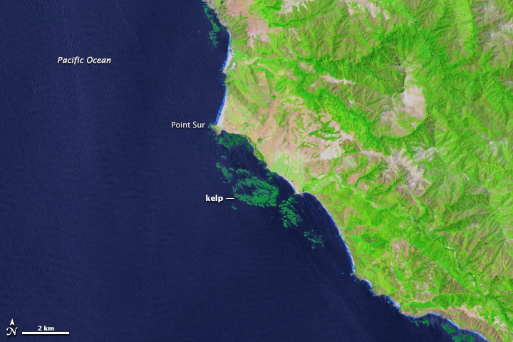
Satellite map view showing the Pacific Ocean coastline at Point Sur with darker green patches identified as kelp beds.
Satellite view of Point Sur and adjacent giant kelp forests along the Big Sur coast.

Monterey Bay National Marine Sanctuary history and protected-area timeline

The path to Monterey Bay National Marine Sanctuary began in the late 1960s, when a Marine Sanctuaries Study Bill was first proposed in 1967 with lobbying from the Sierra Club. The Marine Protection, Research, and Sanctuaries Act of 1972 authorized federal oversight of offshore dumping, and in 1975 the California Coastal Commission recommended the designation of a marine sanctuary in Monterey Bay. By 1976, Santa Cruz and Monterey counties had joined the lobbying effort for protection.

Federal interest shifted over the following years. In 1983, during the Reagan Administration, the area was dropped from sanctuary consideration. Momentum returned in 1988 when Congress re-authorized the Sanctuaries Act and proposed a Monterey Bay sanctuary. Public hearings, still shaped by memories of the 1969 Santa Barbara oil spill, produced strong demands for a larger protected area. A draft environmental impact statement followed in 1990, and a final management plan was released in June 1992.

On September 18, 1992, NOAA designated Monterey Bay National Marine Sanctuary, at the time the largest federal marine sanctuary in the continental United States. In 2008, a boundary change added the Davidson Seamount Management Zone, incorporating a pristine undersea mountain located some 80 miles southwest of Monterey. Early administrative oversight of the sanctuary's northern section was provided by staff from Greater Farallones National Marine Sanctuary, reflecting the cooperative management approach used along California's coast.

Monterey Bay National Marine Sanctuary landscape and geographic character

The physical setting of Monterey Bay National Marine Sanctuary is defined by the meeting of California's central coast with the cold, productive waters of the Pacific. The shoreline runs 276 miles along a varied coastline that includes the iconic cliffs and headlands of Big Sur, the crescent-shaped shore of Monterey Bay, the working harbors of Santa Cruz, and the beaches and estuaries of San Mateo and Marin counties. Inland, the coastal mountains and forested canyons of the Santa Cruz and Big Sur ranges drop steeply toward the sea, shaping both the visual character of the coast and the oceanographic conditions offshore.

The seafloor beneath and beyond these coastal mountains holds some of the sanctuary's most dramatic terrain. The Monterey Submarine Canyon, the largest submarine canyon on the West Coast, cuts a deeply incised gash through the continental shelf and slopes down to extreme depths in the sanctuary, deeper in places than the Grand Canyon. Further offshore, the Davidson Seamount rises thousands of feet from the seafloor as one of the largest and best-preserved seamounts in the region.

Above the water, the sanctuary's atmosphere is shaped by the persistent marine layer, cool ocean breezes, and seasonal fog that characterize the California Current system. Inland waters such as Elkhorn Slough add estuarine character to the coastal landscape, providing sheltered habitats at the inland edge of the protected area. Together, these features create a striking physical environment where rugged cliffs, kelp forests, sandy beaches, and deep submarine canyons all fall within the boundaries of a single protected marine landscape.
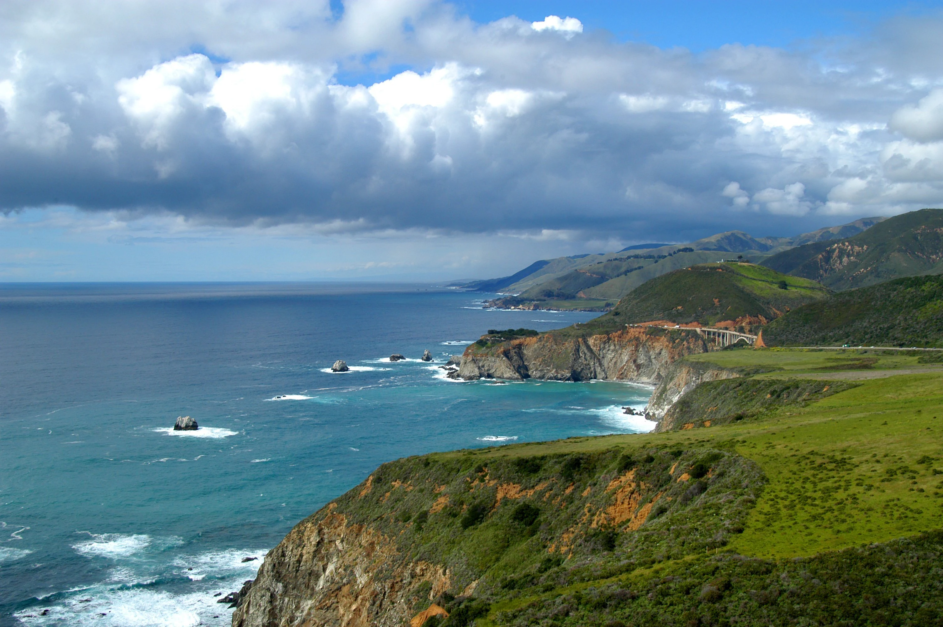
A wide angle view of the California coast, showing green grassy cliffs dropping into the blue Pacific Ocean with the Bixby Canyon Bridge visible in the distance under a partly cloudy sky.
The Big Sur coastline within the Monterey Bay National Marine Sanctuary, featuring the Bixby Canyon Bridge.

Monterey Bay National Marine Sanctuary ecosystems, habitats, and plant life

Monterey Bay National Marine Sanctuary is defined ecologically by the productivity of the California Current system and the diversity of habitats it sustains. Persistent coastal upwelling brings cold, nutrient-rich water to the surface along the central California coast, fueling phytoplankton blooms that anchor an exceptionally productive food web. This productivity is most visibly expressed in the giant kelp forests that grow along nearshore rocky reefs, providing three-dimensional habitat for fish, invertebrates, and marine mammals.

Beyond the kelp forests, the sanctuary includes sandy bottom habitats, rocky reefs, estuarine environments, and the deep pelagic and benthic zones of the Monterey Submarine Canyon and the Davidson Seamount. Each of these habitats supports distinct communities, from filter feeders and rockfish associated with shallow reefs to deep-sea corals and other organisms on the seamount. Estuarine areas such as Elkhorn Slough add brackish and freshwater influences that further expand the sanctuary's ecological range.

Vegetation within the sanctuary extends beyond marine algae to include coastal plant communities along the shoreline and in adjacent protected uplands, while marine vegetation such as kelp and phytoplankton perform the foundational role in the ocean ecosystem. The combination of varied substrates, strong seasonal productivity, and a long, uninterrupted stretch of protected coastline makes MBNMS one of the most ecologically complex marine environments on the Pacific coast of North America.
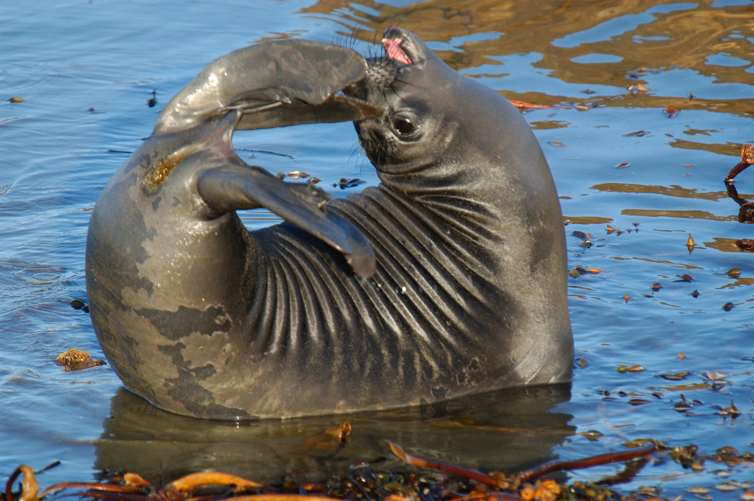
A close-up view of a dark grey Northern elephant seal pup with its body curved into a circle, scratching its head with its hind flipper while partially submerged in blue water containing floating kelp.
A young Northern elephant seal pup resting in the waters of Monterey Bay.

Monterey Bay National Marine Sanctuary wildlife and species highlights

The wildlife of Monterey Bay National Marine Sanctuary is one of the central reasons the area has attracted international scientific and public attention. Marine mammals are particularly conspicuous, with numerous species documented within the sanctuary, including gray whales, humpback whales, blue whales, harbor seals, elephant seals, California sea lions, and sea otters. These animals rely on the sanctuary for breeding, feeding, and migration, with some species drawing visitors along the coast for seasonal whale watching.

Seabirds form another major component of sanctuary wildlife, with dozens of species recorded along the productive shoreline. Pelicans, cormorants, gulls, terns, murres, and other seabirds forage in the upwelling-rich waters, while shorebirds use beaches, estuaries, and tidal flats for feeding and resting. The kelp forests and reefs further shelter a rich community of fishes, including rockfish and other commercially and ecologically important species, as well as invertebrates ranging from sea stars and anemones to market squid.

Sea turtles also occur in the sanctuary's waters, though in smaller numbers than other marine megafauna. Beneath the surface, the invertebrate fauna is extraordinarily diverse, spanning more than two dozen major phyla and reflecting the variety of habitats within MBNMS. Together, these groups make the sanctuary one of the most rewarding destinations in North America for marine wildlife observation and research.
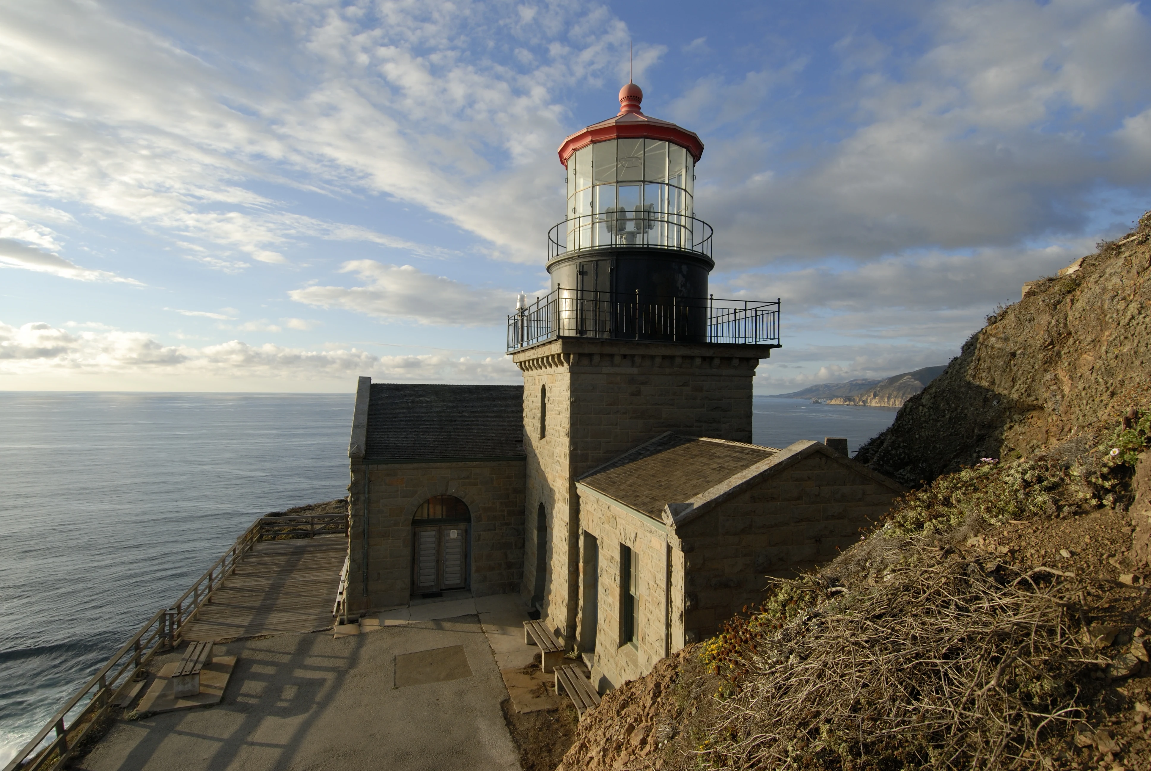
A stone lighthouse with a red-roofed lantern room sits on a cliffside overlooking the Pacific Ocean, with a paved walkway in the foreground and rugged slopes nearby.
The Point Sur Lighthouse perched on a rocky coastal cliff within the Monterey Bay National Marine Sanctuary.

Monterey Bay National Marine Sanctuary conservation status and protection priorities

Monterey Bay National Marine Sanctuary is a cornerstone of marine conservation on the Pacific coast of the United States. Designated in 1992 under federal authority, it is managed to protect marine ecosystems, cultural resources, and water quality over a vast coastal and offshore area. Its regulations prohibit offshore oil drilling and seabed mining, while tightly governing other activities that could affect habitat integrity.

The sanctuary's conservation value lies not only in its legal protections but in the ecological richness it sustains. The cold, upwelling-driven waters within its boundaries support a marine ecosystem of exceptional productivity and biodiversity, while habitats such as kelp forests and the Monterey Submarine Canyon provide refuge for species throughout the food web. Protecting these habitats in a continuous, large-scale area is widely regarded as critical for sustaining marine mammal populations, seabird colonies, fisheries such as Dungeness crab and market squid, and the broader ecological processes of the California Current.

Conservation within the sanctuary is approached collaboratively, involving NOAA staff, an advisory council with diverse local representation, and partnerships with research institutions, state agencies, and the U.S. Coast Guard. Monitoring programs coordinated through the Sanctuary Integrated Monitoring Network (SIMoN) track ecosystem conditions, while education initiatives such as B-WET build long-term public support for stewardship. Despite these protections, ongoing concerns such as elevated microplastic concentrations highlight the sanctuary's role as a working laboratory for understanding and addressing coastal ocean conservation challenges.

Monterey Bay National Marine Sanctuary cultural meaning and human context

Monterey Bay National Marine Sanctuary overlays a coastline of deep and layered cultural history. Long before federal protection, the area was home to indigenous peoples whose lives were closely tied to the rhythms of the Pacific, and the sanctuary's recorded cultural landscape includes hundreds of prehistoric coastal sites alongside more than a thousand reported shipwrecks.

During the era of European exploration, Spanish colonization, and later American settlement, this stretch of coast became a focal point for trade, whaling, fishing, and shipping. The Monterey Bay area was a center of the Pacific sardine fishery and the site of one of the most important fishing communities on the West Coast, experiences that shaped the working maritime identity of cities such as Monterey, Santa Cruz, and Half Moon Bay. The cannery district of Monterey and the wharves of Santa Cruz remain enduring expressions of that heritage.

In more recent decades, the sanctuary has become a setting for new forms of cultural engagement with the ocean, including ecotourism, marine science education, and citizen science programs such as Snapshot Day and Bay Net. These activities extend a long tradition of human interaction with this coast into a contemporary context of stewardship, research, and public learning, while events such as Ocean's Fair at the Coastal Discovery Center connect visitors with both marine science and the broader coastal cultural landscape.

Top sights and standout views in Monterey Bay National Marine Sanctuary

Monterey Bay National Marine Sanctuary stands out for combining extraordinary marine biodiversity with exceptional public accessibility on one of the most scenic stretches of coastline in North America. Its kelp forests, deep submarine canyon, and offshore seamount offer a remarkable cross-section of marine habitats within a single protected area.

The sanctuary is also notable for its integration of research, education, and conservation. Partnerships with major marine science institutions, an active Sanctuary Advisory Council, and visitor centers in San Simeon and Santa Cruz make it both a working scientific landscape and a place where the public can directly engage with the marine environment. Its combination of strict protection from oil drilling and seabed mining with permitted recreation and regulated fishing reflects a balanced model of marine sanctuary management.

Best time to visit Monterey Bay National Marine Sanctuary

The character of a visit to Monterey Bay National Marine Sanctuary shifts noticeably with the seasons. Spring and summer bring warmer, calmer conditions and longer days, making them popular times for coastal sightseeing, kayaking, diving, and visits to the sanctuary's visitor centers. These months are also a productive period for whale watching, with gray whales passing along the coast and humpback and blue whales feeding in the sanctuary's waters.

Fall and winter bring cooler temperatures, rougher seas, and the frequent arrival of the marine layer and Pacific storms that shape the central coast. While conditions can be less comfortable for casual recreation, the winter months are excellent for observing dramatic coastal scenery, storm-driven seas, migrating whales, and concentrations of seabirds. Wildlife viewing opportunities remain strong throughout the year, though specific species and conditions vary with the seasons.

Monthly climate preview

Long term temperature averages and precipitation measurements for Monterey Bay National Marine Sanctuary

Monterey Bay National Marine Sanctuary Climate Normals and Monthly Weather Patterns

Representative coordinate records show measured annual temperature ranges and monthly precipitation totals across Monterey Bay National Marine Sanctuary. Detailed month by month climate normals provide complete historical data for comprehensive environmental analysis.
Annual mean13 °C
12 °C15 °C
Jan12°
Feb12°
Mar12°
Apr12°
May12°
Jun13°
Jul14°
Aug15°
Sep15°
Oct15°
Nov13°
Dec12°
Warmest month
September

15.4 °C

Coolest month
January

11.8 °C

Wettest month
February

2.9 mm/day

Driest month
July

0.1 mm/day

Park location guide

Geography guide, regional context, and park location map for Monterey Bay National Marine Sanctuary

Monterey Bay National Marine Sanctuary park geography, regions, and map view in United States of America

Understand where Monterey Bay National Marine Sanctuary sits in United States of America through a broader geographic reading of the surrounding landscape, nearby location context, and its mapped position within the national park landscape.

How Monterey Bay National Marine Sanctuary fits into United States of America

The United States of America is a federal presidential republic and one of the world's largest countries by area and population. It consists of 50 states across a vast territory spanning multiple time zones, with its capital in Washington, D.C. and largest city in New York City. The nation has a diverse economy, influential political system, and significant cultural and military presence globally.

Wider geography shaping Monterey Bay National Marine Sanctuary in United States of America

The United States occupies a vast territory in North America, bordered by Canada to the north and Mexico to the south. The 48 contiguous states stretch from the Atlantic to the Pacific Ocean, while Alaska occupies the northwestern region and Hawaii is an archipelago in the Pacific. The country encompasses diverse terrain including the Rocky Mountains, Appalachian Mountains, Great Plains, and extensive river systems.

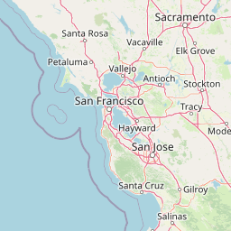
Map view of Monterey Bay National Marine Sanctuary

Use this park location map to pinpoint Monterey Bay National Marine Sanctuary in United States of America, understand its exact geographic position, and read its mapped placement within the surrounding landscape more clearly.

Pigeon | © OpenStreetMap contributors

Location context for Monterey Bay National Marine Sanctuary

California
Recorded earthquake history

View Historical Earthquake Records for Monterey Bay National Marine Sanctuary

Examine the historical record of seismic activity associated with the diverse marine landscapes of Monterey Bay National Marine Sanctuary. This catalogue provides direct access to event dates and magnitude data via MoriAtlas, helping you trace the regional seismic history of this protected area.

Monterey Bay National Marine Sanctuary Earthquake History

Catalogued events

2,801 events

Strongest magnitude

Magnitude 6.9

Most recent event

Aug 13, 2026

This history includes earthquakes recorded inside the park or within 50 km of its borders

Visual reference of coastal terrain, kelp forests, and marine wildlife habitats

Monterey Bay National Marine Sanctuary Photos, Landscapes, and Protected Area Scenery

Examine detailed Monterey Bay National Marine Sanctuary photos to understand the rugged cliffs, offshore canyons, and diverse marine environments defining the protected coastline. Visual records reveal the complex topography and rich habitats spanning from nearshore waters to deep submarine terrain.

Satellite map view showing the Pacific Ocean coastline at Point Sur with darker green patches identified as kelp beds.

A purple striped jellyfish with dark radial markings floating in deep turquoise ocean water, with a smaller jellyfish visible in the background.

A wide angle view of the California coast, showing green grassy cliffs dropping into the blue Pacific Ocean with the Bixby Canyon Bridge visible in the distance under a partly cloudy sky.

A close-up view of a dark grey Northern elephant seal pup with its body curved into a circle, scratching its head with its hind flipper while partially submerged in blue water containing floating kelp.

A stone lighthouse with a red-roofed lantern room sits on a cliffside overlooking the Pacific Ocean, with a paved walkway in the foreground and rugged slopes nearby.

A close up view of a vibrant orange sea anemone with numerous tentacles surrounding its central oral disc.

Park atlas

Compare adjacent coastal landscapes and regional marine reserves across the Pacific shoreline.

Parks Near Monterey Bay National Marine Sanctuary And Surrounding Protected Areas

Browse protected areas and coastal habitats situated near Monterey Bay National Marine Sanctuary to compare regional marine ecosystems. Expanding the geographic scope helps connect adjacent coastal terrain and marine conservation zones within a broader atlas view.
Marine protected areaCalifornia
Park boundaries overlap#1 closest

North

Greater Farallones National Marine Sanctuary: Protected Marine Geography and Atlas Data

Essential marine protected area off the coast of California.

Greater Farallones National Marine Sanctuary protects a vital network of oceanic habitats off California, including sandy beaches, tidal flats, subtidal reefs, and open ocean waters. This marine protected area serves as a critical link in the Pacific coast's network of conservation landscapes, offering a deep look at the geographic connectivity between coastal estuaries and offshore continental shelf environments.

Area
8,530 km²
Established
1981
Relief
Lowland
Climate
Mediterranean
Watercolor painting of a mountain landscape with forested foothills and a valley in the foreground.
Protected landscapeCalifornia
Park boundaries overlap#2 closest

Southeast

Los Padres National Forest: Geography and Protected Landscape Map of Central California

Extensive wilderness corridors and high mountain ridges

Spanning from the Big Sur coastline to the interior ranges of the Santa Lucia and San Rafael mountains, Los Padres National Forest represents a significant protected area in California. The region contains deep gorges, forest-covered canyons, and high-altitude pine ridges that provide essential habitat and support major river headwaters.

Area
7,700 km²
Established
1936
Relief
Mountain
Climate
Mediterranean
Watercolor illustration of a low lying marsh landscape with distant soft pink hills and green vegetation under a white background.
Nature reserveCalifornia
About 1.2 km away#3 closest

East

Elkhorn Slough National Estuarine Research Reserve: Protected Landscapes and Coastal Geography

Mapping the tidal ecosystems of Monterey Bay, California

Located near Watsonville, California, this nature reserve protects a vital estuarine ecosystem marked by tidal channels, mudflats, and oak woodlands. It functions as a key site for coastal research, providing a clear window into the ecology and protected terrain of one of the largest salt marshes remaining on the California coastline.

Area
6.9 km²
Relief
Lowland
Climate
Mediterranean
Access
Easy access
A horizontal watercolor painting showing a rolling landscape with a pond in the foreground, small hills in the background, and soft-colored wildflowers on the banks.
Protected landscapeCalifornia
About 4.9 km away#4 closest

North

Golden Gate National Recreation Area: A Mapped Protected Landscape in California

Coastal geography and historical park terrain overview

An expansive network of protected lands encompassing Pacific shorelines, Marin headlands, and urban forest ecosystems. This recreation area provides a detailed look at the geographic connectivity between coastal redwood groves, military fortifications, and restored wetland corridors within the California Bay Area region.

Area
332.31 km²
Established
1972
IUCN
V
Visitors
15M annual
Watercolor painting of soft, rolling green hills and landscape against a pale background.
Protected landscapeMarin County
7.1 km away#5 closest

North

Point Reyes National Seashore: Exploring the Protected Landscapes of Marin County

Geology, coastal estuaries, and Pacific wilderness boundaries

Point Reyes National Seashore offers a deep look into California coastal geography. The protected area features the dramatic San Andreas Fault, expansive Douglas-fir forests, and rich estuarine habitats, providing an essential study of maritime conservation landscapes and rare breeding grounds for elephant seals and tule elk.

Area
287.44 km²
Established
1962
IUCN
V
Visitors
2.3M annual
Marine protected areaCalifornia
38 km away#6 closest

Northwest

Cordell Bank National Marine Sanctuary: Geographic Atlas and Marine Protected Area Context

Submerged granite seamount and offshore California marine ecosystem

Cordell Bank National Marine Sanctuary is an expansive protected marine zone situated off the California coast. The sanctuary preserves a rare granite underwater mountain that acts as a biodiversity hotspot. Learn about the submerged terrain, continental shelf boundaries, and ecological importance of this significant North American marine conservation area.

Area
3,330 km²
Established
1989
Relief
Lowland
Climate
Mediterranean
A horizontal watercolor painting depicting a wide, winding river flowing through a coastal valley with rolling hills in the background and sparse green vegetation in the foreground.
Marine protected areaCalifornia
48 km away#7 closest

Southeast

Chumash Heritage National Marine Sanctuary: California Marine Protected Area Atlas

Mapping coastal transition zones and submarine seafloor features

Spanning over 4,500 square miles off the Central Coast of California, the Chumash Heritage National Marine Sanctuary represents a critical ecological intersection between northern and southern marine species. The sanctuary includes dramatic underwater terrain like Arguello Canyon, Rodriguez Seamount, and the Santa Lucia Bank, creating a complex habitat that sustains kelp forests and diverse maritime resources.

Area
11,770 km²
Established
2024
IUCN
V
Relief
Mixed relief
National parkCalifornia
51 km away#8 closest

East

Pinnacles National Park: California National Park Geographic Discovery and Map Context

Explore unique protected landscape and regional terrain.

Delve into the protected landscape of Pinnacles National Park, a significant natural area within California. This page offers an atlas-centered view of its unique geological formations and mapped terrain, providing essential context for understanding its geographic identity. Explore the park's specific landscape characteristics and its relation to the broader regional geography and protected areas.

Area
107.67 km²
Established
2013
IUCN
II
Visitors
275K annual

Common questions about visiting, size, designation, and location context for Monterey Bay National Marine Sanctuary

Monterey Bay National Marine Sanctuary FAQs for park facts, access, geography, and protected area context

Find quick answers about Monterey Bay National Marine Sanctuary, including protected-area facts, park geography, trail and visitor context, and how the park fits into its surrounding country and regional landscape.
MoriAtlas Explorer

Continue Your Protected Areas Search Across the Global Atlas

Deepen your exploration by continuing the structured search for national parks and protected areas worldwide. Utilize the comprehensive filtering capabilities to compare different conservation landscapes and refine your understanding of global park geography. Discover more about the distribution and characteristics of protected natural areas.

Global natural geography