Mori Atlas logo
Natural monumentMonumento natural Morros de Macaira

Understanding the karst geography and semi-deciduous forest mosaic of this Venezuelan protected area.

Monumento natural Morros de Macaira: A Geological Overview of Limestone Massifs and Protected Terrain

(Monumento Natural Morros de Macaira)

Monumento natural Morros de Macaira serves as a concentrated example of limestone geology within the interior of Guárico State. This protected area rises abruptly from the surrounding lowlands, with three primary massifs creating a network of vertical cliffs, caves, and seasonal watercourses. The site preserves an isolated patch of montane semi-deciduous forest that contrasts sharply with the nearby regional plains, marking a significant transition between geologic zones.

natural monumentprotected arealimestone geologykarst landscapecaves and cavernsmontane forest

Monumento natural Morros de Macaira

Natural monument

Park overview

Structured park overview, official facts, and landscape profile for Monumento Natural Morros de Macaira

Monumento Natural Morros de Macaira park facts, protected area profile, and essential visitor context

Review the core facts for Monumento Natural Morros de Macaira, including designation, size, terrain, visitor scale, habitats, and operating context in one park-focused overview.

About Monumento Natural Morros de Macaira

Monumento Natural Morros de Macaira occupies a modest footprint in central-northern Venezuela, but its compact geography packs in unusually rich geologic and ecological features. The monument is found in Guárico State, in the municipality of José Tadeo Monagas, where the surrounding countryside is largely shaped by agricultural use and lowland terrain; yet within 99 hectares, the protected landscape shifts abruptly to rugged limestone uplands, forested slopes, and deeply fissured cliffs.

Geology sits at the heart of the park's identity. Three limestone massifs form the structural backbone of the site, and within and around them the forces of water have carved out numerous caves, some of which channel small seasonal torrents. The exposed cliffs often rise as steep near-vertical walls, giving the monument a dramatic appearance that stands out from the broader central Venezuelan landscape and draws attention from researchers interested in karst processes and the area's paleontological record.

Ecologically, Morros de Macaira represents a transition between the dry lowland systems typical of the Guárico region and the moister montane environments associated with the Venezuelan Coastal Range, known locally as the Cordillera de la Costa. This positioning gives the vegetation a distinctive character, including semi-deciduous forest and semi-deciduous scrub that thrive on the slopes and around the rocky outcrops. The combination of unusual substrate, microclimatic variation, and habitat heterogeneity contributes to the monument's value for biodiversity and conservation within a relatively small geographic area.

Quick facts and research context for Monumento Natural Morros de Macaira

Monumento Natural Morros de Macaira is a protected geologic and ecological site in Guárico State, Venezuela, administered by the Instituto Nacional de Parques. It was formally established as a natural monument on 11 November 1978, covering an area of approximately 99 hectares.

Geologically, the monument centers on three limestone massifs that contain caves traversed by small streams, as well as pronounced vertical cliff faces. Ecologically, the vegetation reflects the montane forests of the Venezuelan Coastal Range, with semi-deciduous woodland and semi-deciduous scrub dominating the slopes. The site lies in the municipality of José Tadeo Monagas, near the towns of El Morrito and Altagracia de Orituco, and is bordered on its western edge by the road that connects Altagracia de Orituco with San Francisco de Macaira.

Protection and recognition

Documented terrestrial protection scope and official designation records

Monumento natural Morros de Macaira Protection Status and Recognition Data

Monumento natural Morros de Macaira maintains a documented terrestrial protection scope within the global conservation database. Official records outline the established designation framework and administrative management parameters.

Protection details

Protection scope
Terrestrial
Transboundary protection
No
Park context

Deeper park guide and search-rich context for Monumento Natural Morros de Macaira

Monumento Natural Morros de Macaira history, landscape, wildlife, and travel context

Explore Monumento Natural Morros de Macaira through its history, landscape character, ecosystems, wildlife, conservation priorities, cultural context, and seasonal travel timing in a structured park guide built for atlas discovery and search intent.

Why Monumento Natural Morros de Macaira stands out

Morros de Macaira is best known for its concentration of limestone formations, including three main karstic massifs, an extensive network of caves carved by intermittent torrents, and sharply vertical cliffs that rise abruptly from the surrounding terrain. Paleontological and paleoenvironmental interest in the limestone substrate adds another layer of scientific significance beyond the scenic value of the rock formations. The monument's importance also lies in its ecological role as an isolated patch of montane semi-deciduous forest within the otherwise low-lying interior landscape of central Venezuela. Together, the combination of karstic geology, cave systems, and montane vegetation defines the distinctive identity of this small protected area.
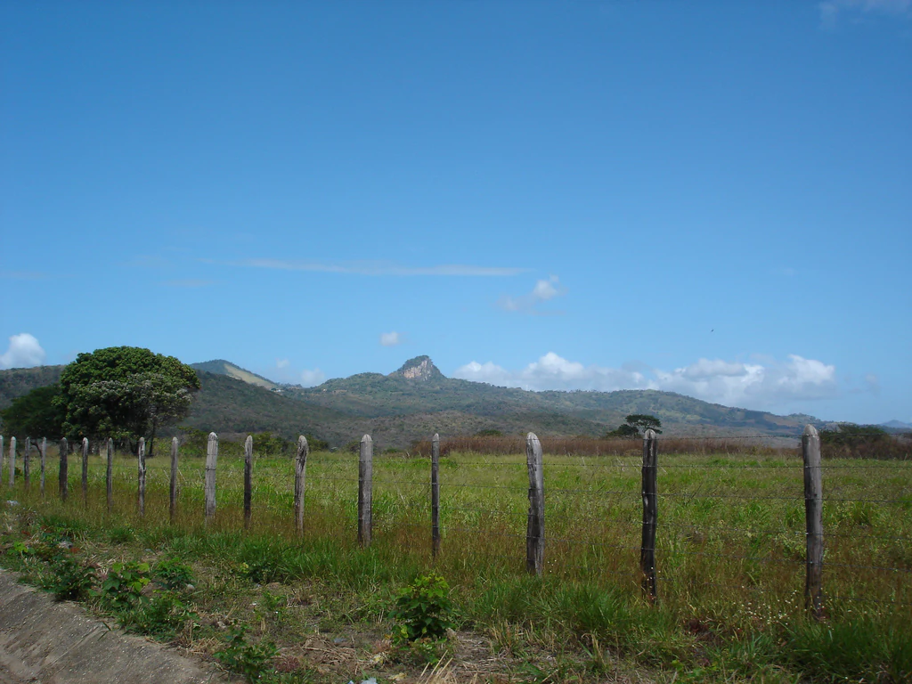
A wide view of a prominent limestone peak rising above rolling grassy hills and a wooden post fence in the foreground.
Limestone formations of the Morros de Macaira Natural Monument in Guarico, Venezuela.

Monumento Natural Morros de Macaira history and protected-area timeline

Monumento Natural Morros de Macaira was formally established as a natural monument under Venezuelan environmental law on 11 November 1978, with the record of its formal founding dates to that moment. The creation of the protected area came in recognition of the site's limestone geology, its cave systems, and the montane vegetation that occupies the slopes, all features considered worthy of long-term protection by the Instituto Nacional de Parques, the national park authority that administers it.

The monument's history reflects Venezuela's broader approach of identifying relatively small but ecologically and geologically significant sites and elevating them to the status of natural monuments, rather than as larger national parks. This designation frames the area as a protected landscape feature of national interest, ensuring that the limestone massifs, cliffs, and forested hills are formally shielded from activities that could disrupt their geological and ecological character. In more recent years, local authorities in Guárico have engaged in work related to mineral extraction around the monument, signaling ongoing tensions between resource use and protection that have shaped the modern management context of the site.

Monumento Natural Morros de Macaira landscape and geographic character

The landscape of Morros de Macaira is defined by the sudden transition from the surrounding lowlands of central Guárico to a cluster of rocky uplands. Three principal limestone massifs dominate the protected area, each contributing a different scale and orientation of outcrops. The rock faces rise in places as near-vertical cliffs, creating sheer walls that give the monument a visually arresting profile and help define its overall silhouette against the sky.

Karstic weathering has shaped much of what is visible on the ground. Small streams and seasonal torrents have exploited weaknesses in the limestone to produce networks of caves and fissures, while the surrounding terrain shows the typical irregular surfaces of eroded carbonate rock. At the margins of the massifs, the landscape softens into forested slopes and valleys that channel the intermittent water flows emerging from the rock.

The broader scenery reflects the meeting point between lowland plains and the foothills of the Venezuelan Coastal Range. This juxtaposition, with rocky uplands and cliffs set within a region otherwise characterized by gentler topography, makes the visual character of Morros de Macaira distinctive, even if its geographic footprint remains compact.

Monumento Natural Morros de Macaira ecosystems, habitats, and plant life

Ecologically, Morros de Macaira sits within the montane forest zone associated with the Venezuelan Coastal Range, or Cordillera de la Costa, despite being surrounded by a region that is generally lower and drier. The vegetation patterns on the site reflect this position: rather than the open savannas or dry forests typical of parts of Guárico, the slopes carry semi-deciduous forests and semi-deciduous scrub that retain their leaf cover for part of the dry season and shed it during the harsher months.

Because the limestone substrate influences water retention and soil chemistry, the microhabitats within the monument vary noticeably across short distances. Rocky outcrops, cave entrances, shaded ravines, and more exposed slopes support different plant communities, contributing to ecological diversity within a small area. The interweaving of montane vegetation with karstic landforms adds ecological value to a site whose primary importance might otherwise be considered purely geological.

This ecological setting is closely connected to the conservation value of the monument. By preserving a patch of montane semi-deciduous forest amid a landscape dominated by agricultural plains, the site supports habitat continuity and serves as a refuge for the species associated with the coastal montane environments.

Monumento Natural Morros de Macaira conservation status and protection priorities

The conservation value of Morros de Macaira rests on three intertwined pillars: the protection of its limestone geology, the preservation of karstic cave systems and their associated microhabitats, and the safeguarding of a patch of montane semi-deciduous forest within a predominantly lowland region. Each of these elements adds a different justification for the site's protected status.

As a natural monument, the site benefits from the formal recognition granted to it by the Venezuelan state and the Instituto Nacional de Parques, which provides a legal framework that constrains activities with the potential to damage the rock formations, caves, or vegetation. The concentrated nature of the protected features within a small area also means that focused management can have a proportionally large impact on the site's overall ecological and geological integrity.

At the same time, the documented involvement of local authorities in extractive activity around the monument highlights the ongoing challenges of balancing conservation with regional economic interests. This dynamic contextualizes the modern conservation profile of the site: a place recognized for geological and ecological importance, formally protected under Venezuelan law, and still actively contested in terms of land use around its margins.

Top sights and standout views in Monumento Natural Morros de Macaira

Morros de Macaira stands out for the visual impact of its three limestone massifs and their vertical cliffs, which create a compact but dramatic geologic landscape within the Guárico interior. The caves threaded by small torrents add an additional dimension, forming natural corridors that researchers and visitors can follow into the interior of the rock formations.

The site is also notable for the paleoenvironmental interest of its limestone substrate, which carries information about the geological history of the region. Combined with the presence of montane semi-deciduous forest, these features give the monument a layered identity that combines geology, biology, and conservation in a relatively small protected area.

Best time to visit Monumento Natural Morros de Macaira

The character of a visit to Morros de Macaira is closely tied to seasonal moisture in central Venezuela. During the wetter months, the small streams and torrents that flow through the caves are more active, enhancing the impression of movement and water within the karstic landscape and making the cave systems more dynamic. In drier months, water levels recede and the vegetation shifts toward a partially leafless state, exposing more of the rock structure.

For visitors interested in the forest and vegetation of the montane slopes, periods after the rainy season often provide a balance between lush greenery and safer access to the rocky terrain. Those focused on geology and paleontology may prefer drier conditions when outcrops and cave entrances are more easily observed and approached.

Monthly climate preview

Long-term temperature ranges and monthly precipitation patterns sampled at representative elevations

Monumento natural Morros de Macaira Climate Normals and Annual Weather Rhythm

Monumento natural Morros de Macaira exhibits a measured annual temperature and precipitation rhythm based on long-term climate normals from representative coordinates. Reviewing the complete twelve-month profile provides detailed monthly averages for temperature ranges and rainfall distribution across the protected landscape.
Annual mean25 °C
24 °C26 °C
Jan24°
Feb25°
Mar26°
Apr26°
May26°
Jun25°
Jul24°
Aug24°
Sep25°
Oct25°
Nov24°
Dec24°
Warmest month
April

26.4 °C

Coolest month
January

23.8 °C

Wettest month
August

5 mm/day

Driest month
March

0.4 mm/day

Park location guide

Geography guide, regional context, and park location map for Monumento Natural Morros de Macaira

Monumento Natural Morros de Macaira park geography, regions, and map view in Venezuela

Understand where Monumento Natural Morros de Macaira sits in Venezuela through a broader geographic reading of the surrounding landscape, nearby location context, and its mapped position within the national park landscape.

How Monumento Natural Morros de Macaira fits into Venezuela

Venezuela is a country in northern South America with coastline along the Caribbean Sea and Atlantic Ocean. It borders Colombia, Brazil, Guyana, and Trinidad and Tobago. The country has an area of approximately 916,445 km² and a population of about 31.8 million. Caracas is the capital and largest city. Venezuela consists of 23 states and the Capital District.

Wider geography shaping Monumento Natural Morros de Macaira in Venezuela

Venezuela is located on the northern coast of South America. The continental territory is bordered by the Caribbean Sea and Atlantic Ocean to the north, Colombia to the west, Brazil to the south, and Guyana to the east. Trinidad and Tobago lies to the northeast. The country includes various islands and islets in the Caribbean Sea known as the Federal Dependencies.

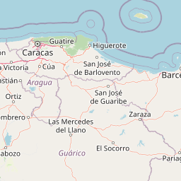
Map view of Monumento Natural Morros de Macaira

Use this park location map to pinpoint Monumento Natural Morros de Macaira in Venezuela, understand its exact geographic position, and read its mapped placement within the surrounding landscape more clearly.

Pigeon | © OpenStreetMap contributors

Location context for Monumento Natural Morros de Macaira

Guárico State

Visualizing the limestone massifs, vertical cliffs, and karstic terrain of the Guárico interior.

Monumento natural Morros de Macaira Photos and Landscape Scenery

Photographic records capture the striking vertical cliffs and prominent limestone massifs defining the topography of Monumento natural Morros de Macaira. Visual reference documentation reveals the rugged karstic terrain and isolated montane forest habitats within the surrounding lowlands.

A wide view of a prominent limestone peak rising above rolling grassy hills and a wooden post fence in the foreground.

Park atlas

Compare regional geology, karstic terrain, and adjacent protected areas across central Venezuela.

Exploring Parks Near Monumento natural Morros de Macaira and Surrounding Protected Landscapes

Continue browsing other parks near Monumento natural Morros de Macaira to compare distinctive limestone massifs with neighboring protected landscapes. Evaluating adjacent regional geography reveals broader patterns in regional conservation and terrain variation.
National parkMiranda
About 32 km away#1 closest

Northeast

Guatopo National Park: Venezuela's National Park Mapped Landscape Context

Discover Guatopo National Park's protected area geography.

Guatopo National Park represents a key protected natural landscape in Venezuela's Miranda region. This entry offers detailed geographic context, focusing on the park's mapped boundaries and its status as a national park. It is designed for users seeking structured information about protected areas, enabling a deeper understanding of natural landscapes and their regional distribution within an atlas framework. Explore the park's distinct protected-area identity and its place in the national geography.

Area
1,224.64 km²
Established
1958
IUCN
II
Relief
Mixed relief
Watercolor painting showing a winding river flowing through a landscape with rolling hills in the background
National parkVenezuela
About 67 km away#2 closest

North

El Ávila National Park: Venezuela's Premier Coastal Mountain National Park Exploration

Discover diverse terrain, mapped boundaries, and unique geographic context.

El Ávila National Park offers an exceptional gateway into Venezuela's mountainous protected landscapes. This national park features a dramatic rise from the Caribbean coast into varied terrain, including unique cloud forest and alpine zones. Its mapped geography showcases steep slopes, deep ravines, and remarkable elevation changes, providing a significant atlas-style study of coastal mountain environments. Exploring El Ávila National Park reveals a vital natural barrier and a rich ecosystem supporting diverse flora and fauna, making it a key destination for understanding regional protected areas.

Area
819 km²
Established
1958
IUCN
II
Relief
Mountain
National parkVenezuela
About 75 km away#3 closest

Northwest

Macarao National Park: Venezuela's National Park with Mapped Boundaries and Regional Atlas Context

Explore its protected landscape and geographic setting within South America.

Delve into Macarao National Park, a significant national park situated in Venezuela. This page offers an atlas-centric view of the park, detailing its mapped boundaries and highlighting its importance within the regional geography of northern South America. Understand how Macarao National Park contributes to the country's network of protected landscapes and provides foundational geographic context for explorers and researchers.

Area
150 km²
Established
1973
IUCN
II
Relief
Mountain
Natural monumentMiranda
About 78 km away#4 closest

Northeast

Monumento natural Cueva Alfredo Jahn: Exploring Protected Limestone Caves in Miranda

Geology, karst topography, and cave system mapping

Monumento natural Cueva Alfredo Jahn serves as a primary geological research site and protected natural area in the Serranía Litoral. The cave system, shaped by perennial waterways, features significant calcite formations and mineral rarity. Examine the mapped extent, elevations, and landscape context of this central Venezuelan cave complex.

Area
0.58 km²
Established
1978
IUCN
III
Visitors
3.5K annual
A horizontal watercolor illustration of gentle, rolling green hills and faint, distant mountains against a soft, pale background.
Natural monumentGuárico
About 84 km away#5 closest

West

Monumento Natural Arístides Rojas: Protected Limestone Landscapes in Guárico, Venezuela

Geological exploration of the iconic Los Morros limestone formation

Monumento Natural Arístides Rojas represents a significant protected area in central Venezuela, defined by its dramatic Paleocene limestone hills. This site serves as a vital geological monument, featuring karst caves, steep rocky ridges, and expansive views over San Juan de los Morros. Browse geographic terrain data and trace the boundaries of these sharp, tooth-like hills that characterize the regional landscape transition into the Venezuelan llanos.

Area
27.75 km²
Established
1949
Relief
Mountain
Water
Minor water
Watercolor painting of a lagoon surrounded by green vegetation and mountains in the background
National parkMiranda State
About 88 km away#6 closest

Northeast

Laguna de Tacarigua National Park: Protected Area and Miranda State Geography

Mapped natural landscape and park boundaries in Venezuela.

Laguna de Tacarigua National Park is a designated national park offering critical protected landscape features within Miranda State. This park provides essential context for understanding Venezuela's protected areas, with a focus on its mapped boundaries and regional geographic setting. Dive into the atlas-style details to comprehend its place in the natural landscape.

Area
391 km²
Established
1974
IUCN
II
Relief
Lowland
Natural monumentAragua
About 94 km away#7 closest

Northwest

Monumento Natural Pico Codazzi: Karst Landscapes and Mountain Corridors in Aragua

Exploring protected summit terrain and regional mountain connectivity

Spanning over 11,850 hectares, Monumento Natural Pico Codazzi preserves a complex mountain landscape defined by limestone massifs, vertical cliffs, and subterranean cave systems. Located in Aragua, this protected area functions as a biological bridge between major national parks, safeguarding a critical environment for migratory bird transit and high-altitude cloud forest stability across the Coastal Range.

Area
118.5 km²
Established
1991
Relief
Mountain
Climate
Tropical
National parkGuárico
About 100 km away#8 closest

South

Aguaro-Guariquito National Park: Protected Landscape and Geographic Mapping

Explore its Guárico regional setting and mapped park boundaries.

Aguaro-Guariquito National Park stands as a vital protected natural area within the Guárico region of Venezuela. This entry offers an atlas-centric view, focusing on the park's mapped boundaries and its role as a national park. Delve into its geographic identity and the context it provides for understanding protected landscapes in the area.

Area
5,857 km²
Established
1974
IUCN
II
Relief
Lowland

Common questions about visiting, size, designation, and location context for Monumento Natural Morros de Macaira

Monumento Natural Morros de Macaira FAQs for park facts, access, geography, and protected area context

Find quick answers about Monumento Natural Morros de Macaira, including protected-area facts, park geography, trail and visitor context, and how the park fits into its surrounding country and regional landscape.
MoriAtlas Explorer

Continue Your Protected Areas Search Across the Global Atlas

Deepen your exploration by continuing the structured search for national parks and protected areas worldwide. Utilize the comprehensive filtering capabilities to compare different conservation landscapes and refine your understanding of global park geography. Discover more about the distribution and characteristics of protected natural areas.

Global natural geography