Mori Atlas logo
National parkMoukalaba-Doudou National Park

Tracing the mapped boundaries and natural terrain of this essential Central African protected landscape

Moukalaba-Doudou National Park: Comprehensive Geographic Atlas and Protected Area Boundaries in Gabon

Moukalaba-Doudou National Park stands as a defining element of the Gabon protected area network; a sprawling wilderness preserve situated in the heart of Central Africa. This detailed geographic analysis reveals the park boundaries and regional landscape context, providing a clear understanding of its role within the dense tropical forest ecosystems of the country. Explore the terrain and structural geography that define this significant site in the national conservation framework.

protected areaCentral Africatropical forestGabonnational parkwildlife conservation

Moukalaba-Doudou National Park

National park

Park overview

Structured park overview, official facts, and landscape profile for Moukalaba-Doudou National Park

Moukalaba-Doudou National Park park facts, protected area profile, and essential visitor context

Review the core facts for Moukalaba-Doudou National Park, including designation, size, terrain, visitor scale, habitats, and operating context in one park-focused overview.

About Moukalaba-Doudou National Park

Moukalaba-Doudou National Park is a protected area located in Gabon, a Central African country renowned for its extensive forest coverage and biodiversity conservation efforts. The park forms part of Gabon's national network of protected areas, which are designed to preserve the country's exceptional tropical ecosystems, including lowland rainforest, wildlife habitats, and riparian zones. Gabon's protected area system is recognized as one of the most robust in Central Africa, with parks managed under the country's environmental protection framework. This particular park contributes to the broader conservation landscape of Gabon, which hosts significant populations of forest elephants, gorillas, and other endangered species across its protected territories.

Quick facts and research context for Moukalaba-Doudou National Park

Moukalaba-Doudou National Park is situated in Gabon, a nation in Central Africa known for its dense tropical rainforests and commitment to biodiversity preservation. The park is part of Gabon's national parks system, which covers substantial portions of the country's territory and is managed with support from national environmental agencies and international conservation partnerships.

Protection and recognition

Examine documented protection scope, management designation history, and recognition sources.

Moukalaba-Doudou National Park Protection Status and International Recognition

Moukalaba-Doudou National Park protection status details bring together documented designation history and management scope. Systematic conservation records outline official administrative frameworks and verified international recognition sources.

Protection details

Transboundary protection
No
Monthly climate preview

Long-term monthly precipitation patterns and temperature cycles across the park terrain

Moukalaba-Doudou National Park Climate Normals and Annual Temperature Rhythm

Representative coordinates record distinct seasonal shifts in monthly precipitation alongside steady annual temperatures across the protected landscape. Examining the full twelve-month climate profile reveals comprehensive statistical averages for regional analysis.
Annual mean25 °C
23 °C25 °C
Jan25°
Feb25°
Mar25°
Apr25°
May25°
Jun24°
Jul23°
Aug23°
Sep25°
Oct25°
Nov25°
Dec25°
Warmest month
March

25.5 °C

Coolest month
July

22.7 °C

Wettest month
November

11.9 mm/day

Driest month
July

0.1 mm/day

Park location guide

Geography guide, regional context, and park location map for Moukalaba-Doudou National Park

Moukalaba-Doudou National Park park geography, regions, and map view in Gabon

Understand where Moukalaba-Doudou National Park sits in Gabon through a broader geographic reading of the surrounding landscape, nearby location context, and its mapped position within the national park landscape.

How Moukalaba-Doudou National Park fits into Gabon

Gabon is a Central African country on the Atlantic coast, positioned on the equator. It gained independence from France in 1960 and is governed as a unitary presidential republic. The country has significant oil wealth and one of the highest Human Development Index rankings in Africa, though wealth distribution remains uneven.

Wider geography shaping Moukalaba-Doudou National Park in Gabon

Gabon is situated on the Atlantic coast of Central Africa, positioned along the equator. It borders Equatorial Guinea to the northwest, Cameroon to the north, and the Republic of the Congo to the east and south. The terrain includes coastal plains along the Atlantic, mountain ranges in the center (the Cristal Mountains and Chaillu Massif), and savanna zones in the east.

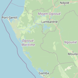
Map view of Moukalaba-Doudou National Park

Use this park location map to pinpoint Moukalaba-Doudou National Park in Gabon, understand its exact geographic position, and read its mapped placement within the surrounding landscape more clearly.

Pigeon | © OpenStreetMap contributors
Park atlas

Compare adjacent tropical forest reserves and regional conservation landscapes

Explore Protected Areas and Parks Near Moukalaba-Doudou National Park

Browsing other protected areas near Moukalaba-Doudou National Park reveals connected tropical ecosystems across the surrounding region. Extended park comparison highlights broader conservation networks and regional geographic patterns.
National parkGabon
Mapped park locations coincide#1 closest

Moukalaba-Doudou National Park: Protected Forest and Savanna Mosaic in Southeastern Gabon

Geographic overview of a key Central African protected area.

Moukalaba-Doudou National Park represents a significant protected area in southeastern Gabon, covering 4,500 square kilometers of diverse terrain. The park is defined by its unusual interaction between humid tropical rainforest and expansive savanna grasslands, marking it as a critical ecological transition zone in the Congo Basin region.

Area
4,500 km²
IUCN
II
Scope
Terrestrial
Water
Minor water
National parkGabon
About 73 km away#2 closest

West

Loango National Park: Gabon's Coastal Wilderness and Unique Protected Landscape

Explore savanna, forest, beach, and lagoon ecosystems in this vital national park.

Loango National Park in Gabon is a significant protected area recognized for its remarkable geographic diversity. This national park encompasses over 100 kilometers of pristine, uninhabited Atlantic coastline, rare mangrove systems, and expansive savanna plains transitioning into dense tropical forests. Its unique landscape, particularly the Iguéla Lagoon, offers rich opportunities for atlas-style exploration of coastal ecosystems and protected areas. Understanding the park's mapped boundaries and regional setting is key to appreciating its ecological importance.

Area
1,550 km²
Established
2002
IUCN
II
Relief
Lowland
Wildlife reserveOgooué-Maritime
About 92 km away#3 closest

West

Zone humide de Petit Loango Wildlife Reserve: Regional Atlas and Protected Area Context

Extensive coastal wetland complex in Ogooué-Maritime, Gabon

Examine the geographic boundaries and landscape composition of Zone humide de Petit Loango. This Ramsar-recognized site in Ogooué-Maritime encompasses the Petit Loango Fauna Reserve alongside associated hunting domains, creating a unique coastal environment defined by dense mangrove networks, river estuaries, and inland freshwater swamps.

Area
4,800 km²
Established
1986
Relief
Lowland
Scope
Mixed
National parkGabon
About 127 km away#4 closest

Northeast

Waka National Park: A Mapped Protected Landscape in Gabon's Geography

Explore the natural terrain and park boundaries of this national park.

Waka National Park in Gabon represents a vital protected landscape for geographic exploration. This dedicated detail page offers insight into the park's specific mapped area and its place within the country's broader natural terrain. Understand its context as a national park, contributing to the atlas of protected areas in Central Africa. Discover the geographic identity of this significant natural reserve.

Area
1,060 km²
Established
2002
IUCN
II
Relief
Mountain
National parkGabon
About 165 km away#5 closest

Southeast

Mayumba National Park: Gabon's Equatorial Protected Area and Geographic Atlas

Explore mapped park boundaries and regional landscape context.

Delve into the geographic identity of Mayumba National Park, a significant protected area situated in Gabon. This detail page provides atlas-style insights into the park's mapped boundaries, its position within the equatorial geography of Central Africa, and its role as a national park. Understand the protected landscape's environmental context and its atlas significance.

Area
870 km²
Established
2002
IUCN
II
Relief
Lowland
Watercolor painting of a landscape with grassy areas, a lake, and distant hills under a light sky
National parkGabon
About 187 km away#6 closest

Northeast

Lopé National Park: Gabon's Protected Landscape and National Park Geography

Explore mapped boundaries and natural terrain in Central Africa.

Delve into Lopé National Park, a designated national park situated in Gabon. This protected area serves as a crucial point for understanding the nation's geography and the distribution of its conservation landscapes. As an entry in the MoriAtlas, it offers a detailed view of its mapped territory and its contribution to the broader regional context of Central Africa, emphasizing its role in protected area atlas exploration.

Area
4,910 km²
Established
2002
IUCN
II
Relief
Mixed relief
Wildlife reserveEstuaire
About 200 km away#7 closest

Northwest

Réserve de Wonga Wongué: Atlantic Coastal Protected Landscape and Wildlife Map

Explore the geography of Gabon's expansive lowland coastal reserve

Examine the geographic boundaries and protected landscape of Réserve de Wonga Wongué, a crucial site in Gabon that features a blend of forest, hill, and plateau terrain. This reserve provides a comprehensive look at coastal river systems, marshes, and the habitats of central African megafauna along the Atlantic shore, highlighting its role as a Ramsar Wetland of International Importance and its evolving identity as a conservation area.

Area
4,281 km²
Established
1972
Watercolor painting showing a river with green hills and pink flowers in the foreground
National parkKouilou Department
About 201 km away#8 closest

Southeast

Conkouati-Douli National Park: Mapping Protected Landscape Boundaries and Regional Geography

Explore its national park status and geographic context.

Conkouati-Douli National Park is a protected area situated in the Kouilou Department, offering a focused point for geographic and landscape discovery. This detail provides an atlas-style perspective on its mapped boundaries and its contribution to the regional geography. Understand the park as a distinct natural landscape and a key component of conservation within its geographic setting.

Area
7,955 km²
Established
1999
IUCN
II
Relief
Lowland

Common questions about visiting, size, designation, and location context for Moukalaba-Doudou National Park

Moukalaba-Doudou National Park FAQs for park facts, access, geography, and protected area context

Find quick answers about Moukalaba-Doudou National Park, including protected-area facts, park geography, trail and visitor context, and how the park fits into its surrounding country and regional landscape.
MoriAtlas Explorer

Continue Your Protected Areas Search Across the Global Atlas

Deepen your exploration by continuing the structured search for national parks and protected areas worldwide. Utilize the comprehensive filtering capabilities to compare different conservation landscapes and refine your understanding of global park geography. Discover more about the distribution and characteristics of protected natural areas.

Global natural geography