Why Mount Richmond Forest Park stands out
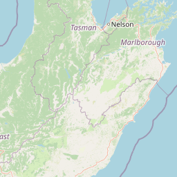
Mount Richmond Forest Park is best known for being one of the large, bush-dominated forest parks of New Zealand's northern South Island, with an extensive network of tramping tracks and backcountry huts. Its namesake summit, Mount Richmond, gives the park a defining high-country backdrop, while its position between Nelson and Marlborough makes it an important transitional landscape between two very different regional settings.
Mount Richmond Forest Park history and protected-area timeline
Mount Richmond Forest Park has a history shaped by both natural and human events. The forest park in its modern protected form was established in 1977, when the New Zealand government brought together a large tract of conservation land between Nelson and Marlborough under forest park status. This designation reflected the area's value as extensive native bush and rugged hill country, and placed the reserve under the management of what is now the Department of Conservation.
The surrounding landscape, however, has a longer and more tragic history. In May 1942, the upper slopes of Mount Richmond became the site of New Zealand's first deadly civilian aviation incident associated with regular passenger air service, when a plane en route from Wellington to Nelson was lost in the area. The subsequent search located a burnt-out aircraft on the mountain with no survivors, marking a sobering moment in the early history of New Zealand's domestic aviation and embedding the location into the country's wider transport history.
In the decades since, the park's history has been defined less by dramatic events and more by its role as a working conservation area and recreational landscape. Track development, hut construction, and the eventual inclusion of parts of the route in Te Araroa have helped turn the forest park into a well-used backcountry destination while preserving its forested, lightly developed character.
Mount Richmond Forest Park landscape and geographic character
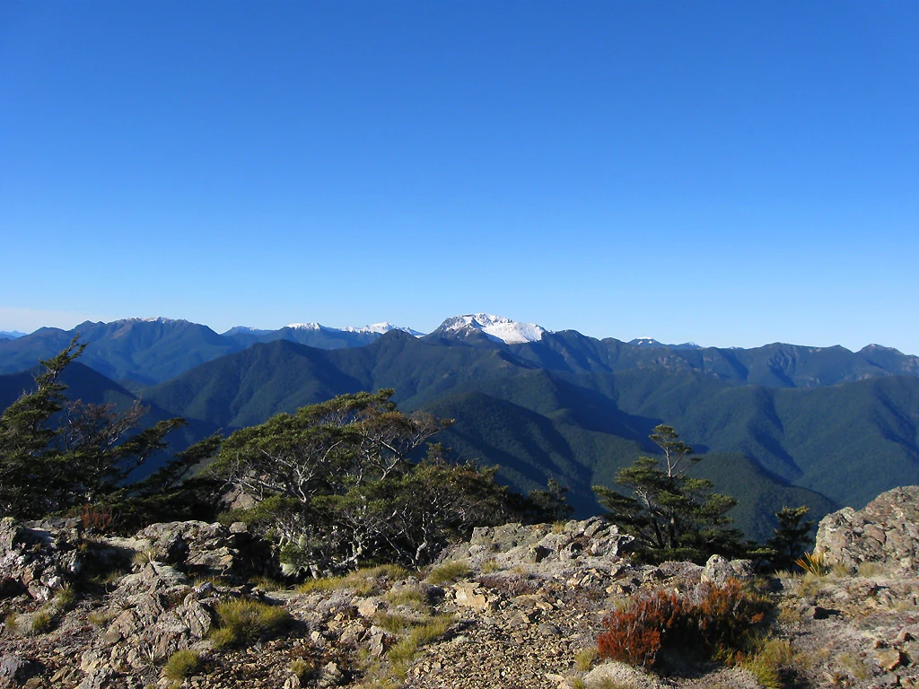
The landscape of Mount Richmond Forest Park is dominated by forested hill country transitioning into higher, more exposed mountain terrain. Across most of the park, native bush cloaks the slopes, producing a continuous green canopy broken only by rivers, clearings, and the occasional ridge or bluff. This dominant bush cover gives much of the park a deeply wooded, enclosed feel.
Above the bush line, the terrain shifts into a more open high country of ridges, peaks, and saddles. Mount Richmond itself, the park's highest point at over 1,750 metres, dominates the skyline and influences the surrounding topography. Nearby summits such as Mounts Rintoul, Fell, and Fishtail add to the dramatic skyline visible from higher vantage points, including tracks like Gibbs Spur. Together these peaks form a recognizable mountain cluster within the larger forest park.
The valleys between the peaks carry rivers and streams that have carved the underlying terrain, producing a varied pattern of broad basins and narrow gorges. Together with the bordering hills, the interplay of dense forest, ridgelines, and clear mountain summits defines the visual identity of the park from both within and from the air.
Mount Richmond Forest Park ecosystems, habitats, and plant life
Ecologically, Mount Richmond Forest Park is defined by its extensive native bush cover, which extends across roughly four-fifths of the protected area. This proportion of forest makes the park a major repository of native vegetation on the northern South Island, preserving extensive stands of indigenous trees and associated understorey rather than the patchwork of pasture and production forest seen in many other parts of the country.
The park spans an elevation range from valley floors up to subalpine peaks above 1,700 metres, allowing it to host several vegetation zones in a single continuous landscape. Lower slopes and valleys support broadleaved and mixed forest typical of the northern South Island, while higher elevations transition into thinner forest, scrub, and ultimately open rock and tussock around the summits. This vertical layering creates a clear ecological gradient within a relatively compact geographic range.
Because of its size and the continuity of its bush cover, the park also plays an important role as habitat for forest-dependent native species, providing extensive interior forest well away from roads and urban edges. The combination of large forested area and altitudinal diversity makes the park a key component of the regional conservation network between Nelson and Marlborough.
Mount Richmond Forest Park conservation status and protection priorities
Mount Richmond Forest Park is significant from a conservation perspective primarily because of the sheer scale of native bush it preserves in a continuous block. With approximately 80 percent of its land area under indigenous forest and the remainder comprising rugged hill and high-country terrain, the park protects a large working example of the northern South Island's native vegetation cover.
Administered by the Department of Conservation, the forest park forms part of New Zealand's broader conservation estate and provides interior habitat well away from the heavily modified lowlands that surround it. Its elevation range, from valley forests to peaks above 1,700 metres, allows it to conserve multiple vegetation zones within a single protected landscape.
The park's conservation role is also reinforced by its relatively light modification and large size, which together support ecological processes across an extensive area. This makes it an important counterweight to the more fragmented forest remnants and heavily logged or converted land found elsewhere in the surrounding regions.
Mount Richmond Forest Park cultural meaning and human context
The cultural context of Mount Richmond Forest Park is shaped mainly by its place in New Zealand's outdoor and transport history. The upper slopes of Mount Richmond hold a notable place in early New Zealand aviation history as the site of the country's first fatal civilian aviation accident linked to scheduled passenger air services, an event that has given the mountain an unanticipated historical layer beyond its natural role.
In more recent decades, the park has become culturally significant as a destination for backcountry recreation. It is increasingly tied to Te Araroa, New Zealand's long-distance trail, which routes through sections of the forest park and links the area into a national narrative of long walks and wilderness travel. Together, these threads give the park a cultural profile that is small but distinctive within the wider New Zealand outdoors.
Top sights and standout views in Mount Richmond Forest Park
Mount Richmond Forest Park's standout qualities include the sheer extent of its native bush cover, the prominence of its namesake summit above 1,700 metres, and the presence of an extensive network of tramping tracks and backcountry huts. The park's location between Nelson and Marlborough also gives it a transitional character, linking two of the South Island's distinctive regional identities.
Equally notable is the park's role as a quiet but historically significant landscape: the upper slopes of Mount Richmond remember one of New Zealand's earliest civil aviation tragedies, while the modern park serves as a working conservation area and a section of Te Araroa. The combination of forest, mountain scenery, recreational infrastructure, and understated historical weight makes the park a uniquely layered northern South Island reserve.
Best time to visit Mount Richmond Forest Park
Mount Richmond Forest Park is a temperate, mountainous reserve where seasonal conditions strongly shape the experience of visiting. Summer and the broader warm months are typically the most accessible period, when longer daylight, drier tracks, and snow-free higher elevations make the full network of tramping routes and huts available for visitors who want to reach the park's upper valleys and ridgelines.
In the cooler months, conditions become more demanding, with colder temperatures, shorter days, and snow on the higher peaks around Mount Richmond and its neighbouring summits. The bush at lower elevations remains a feature year-round, but winter travel in the park generally requires more preparation and experience.
Because seasonal conditions can change quickly in this part of the northern South Island, visitors benefit from planning around settled summer weather for the broadest access, or accepting more limited but quieter experiences in the shoulder seasons when bush, river valleys, and lower tracks remain rewarding even if higher routes are less accessible.