Mori Atlas logo
National parkMunchique National Natural Park

Geographic context and mapped boundaries for this protected area in Cauca Department.

Munchique National Natural Park: National Park with Protected Landscape Identity

(Parque Nacional Natural Munchique)

Munchique National Natural Park stands as a significant protected area within the Cauca Department of Colombia, designated as a National Park. This page serves as an entry point to understanding its precise geographic scope, mapped boundaries, and its role as a distinct natural landscape. Explore how this park contributes to the regional geography and offers a unique setting for atlas-based discovery.

Andean cloud forestsBiodiversity hotspotBirdwatching destinationEndemic species refugeCordillera OccidentalColombian national parks

Munchique National Natural Park

National park

Park overview

Structured park overview, official facts, and landscape profile for Munchique National Natural Park

Munchique National Natural Park park facts, protected area profile, and essential visitor context
Review the core facts for Munchique National Natural Park, including designation, size, terrain, visitor scale, habitats, and operating context in one park-focused overview.

About Munchique National Natural Park

Munchique National Natural Park occupies a critical position in Colombia's protected area network, preserving a representative sample of the Cordillera Occidental's western slope ecosystems. The park's territory encompasses the headwaters of several major tributaries to the San Juan de Micay River, which flows westward to the Pacific Ocean, making the protected area essential for watershed protection across a broad region. The diverse topography, ranging from steep Andean slopes to valley floors, creates numerous microhabitats that support the park's extraordinary biodiversity. Originally designated primarily for its ecological and watershed values, the park now faces challenges from illegal crop cultivation and other ecological threats that endanger its long-term conservation status. The proximity to populated municipalities including El Tambo, Lopez, Morales, and Cajibio creates both opportunities for local engagement in conservation and pressures from surrounding land use. The park remains one of the most biodiverse regions in Colombia, with species counts that place it among the country's premier protected areas for both flora and fauna.

Quick facts and research context for Munchique National Natural Park

Munchique National Natural Park spans 440 square kilometers along the western slopes of the Cordillera Occidental in Colombia's Cauca Department, approximately 61 kilometers from the city of Popayán. The protected area encompasses Munchique Mountain and features 30 streams and rivers with 40 waterfalls throughout its territory. The elevation gradient from 200 to 3,500 meters creates three distinct climate zones: warm at lower elevations, temperate in the middle ranges, and cold at higher altitudes. Average temperatures range from 24°C in the lowlands to 8°C at the highest points, while annual rainfall varies from 3,000 mm in the upper zones to 5,000 mm in the lower areas, with December being the wettest month and June through August the driest period. The park is governed by Colombia's National System of Protected Areas (SINAP).

Park context

Deeper park guide and search-rich context for Munchique National Natural Park

Munchique National Natural Park history, landscape, wildlife, and travel context
Explore Munchique National Natural Park through its history, landscape character, ecosystems, wildlife, conservation priorities, cultural context, and seasonal travel timing in a structured park guide built for atlas discovery and search intent.

Why Munchique National Natural Park stands out

Munchique National Natural Park is best known for its remarkable ornithological diversity, particularly its extraordinary hummingbird populations with 37 species recorded within its boundaries. The park serves as a refuge for several endemic and endangered bird species, including the long-wattled umbrellabird and the colorful puffleg, the latter found nowhere else on Earth. The presence of the Munchique wood-wren, a species discovered and named after the park in 2003, further underscores its global significance for avian conservation. Beyond birds, the park protects substantial populations of large mammals including jaguars, pumas, and spectacled bears, along with 182 mammal species in total. The combination of cloud forest, Andean forest, and paramo ecosystems across its elevation gradient creates one of Colombia's most biodiverse protected landscapes.

Munchique National Natural Park history and protected-area timeline

Munchique National Natural Park was established as a national park in May 1977, representing Colombia's commitment to preserving the exceptional biodiversity of its Andean regions. The creation of the park responded to growing recognition of the ecological significance of the Cordillera Occidental's western slopes, which had remained relatively undisturbed due to the region's rugged terrain and limited agricultural development. The park was named for Munchique Mountain, a prominent geological feature in the southeastern portion of the protected area that has become synonymous with the region's identity. Following its establishment, the park was integrated into Colombia's National System of Protected Areas (SINAP), the framework governing the nation's network of protected territories. The year 2003 marked a significant discovery in the park's biological heritage with the identification of the Munchique wood-wren, a new bird species named after the protected area, demonstrating that even well-studied parks continue to yield new scientific discoveries.

Munchique National Natural Park landscape and geographic character

The landscape of Munchique National Natural Park is defined by its position on the western flank of the Cordillera Occidental, where steep mountain slopes descend toward Colombia's Pacific coastal lowlands. The terrain is characterized by deep river valleys, cascading waterfalls, and ridgelines that rise to elevations exceeding 3,500 meters above sea level. Munchique Mountain itself forms a prominent backdrop in the southeastern sector of the park, its slopes cloaked in dense vegetation across multiple elevational zones. The drainage network within the park includes approximately 30 streams and rivers, many tumbling over precipices to form the 40 waterfalls that punctuate the landscape. These waterways ultimately converge as tributaries to the San Juan de Micay River, one of the major river systems draining the Colombian Pacific basin. The combination of high rainfall, steep topography, and elevation-driven climate variation creates a landscape of exceptional visual and ecological diversity.

Munchique National Natural Park ecosystems, habitats, and plant life

The ecological character of Munchique National Natural Park is defined by its exceptional biodiversity and the presence of multiple distinct habitat types arranged along the park's dramatic elevation gradient. At lower elevations below 1,000 meters, warm tropical conditions support tall canopy trees exceeding 40 meters in height, while the temperate zone between 1,000 and 2,000 meters features increasingly dense forest with abundant epiphytes, a sign of the cloud forest conditions that prevail in these middle elevations. Above 2,000 meters, the cold zone gives way to paramo vegetation characteristic of high-elevation Andean ecosystems. The park's biodiversity indices rank among the highest in Colombia, a result of the combination of minimal human disturbance, the diversity of thermal levels, and the park's position as a corridor connecting lowland Pacific ecosystems with Andean mountain environments. This ecological wealth is expressed in the impressive species counts: approximately 500 bird species, 182 mammal species, 71 amphibians, 70 bats, and 55 butterfly species have been documented within the park's boundaries.

Munchique National Natural Park wildlife and species highlights

The wildlife of Munchique National Natural Park represents one of the most diverse assemblages in Colombia, with particular significance for bird populations and large Neotropical mammals. The park's approximately 500 bird species include 37 hummingbird species, making it an exceptional destination for ornithological study and observation. The long-wattled umbrellabird and colorful puffleg rank among the most notable avian residents, with the latter being endemic to the region. The 2003 discovery of the Munchique wood-wren, named after the park, represents one of the more recent additions to the known avifauna. Mammalian residents include significant populations of large cats, with jaguars, pumas, and three species of ocelot present in the park. The spectacled bear, South American coati, northern pudú, and porcupine represent additional mammalian diversity, while the scaly-footed small-eared shrew adds to the park's complement of smaller mammals. The Western Andes toad is known only from this protected area, underscoring the park's global significance for amphibian conservation.

Munchique National Natural Park conservation status and protection priorities

Munchique National Natural Park holds significant conservation importance as one of Colombia's most biodiverse protected areas, harboring species found nowhere else on Earth. The park protects critical habitat for endemic species including the colorful puffleg bird and the Western Andes toad, both of which are known only from this region. The presence of large predators including jaguars and pumas indicates the existence of intact ecological communities and functional food webs. However, the park faces serious threats from illegal crop cultivation and other ecological pressures that endanger its long-term ecological integrity. Conservation efforts must balance the protection of this biodiversity hotspot with the needs of surrounding communities while addressing the specific threats that challenge the park's ecological health. The designation as a national park and its integration into Colombia's protected area network provides a framework for ongoing conservation management.

Munchique National Natural Park cultural meaning and human context

The Munchique National Natural Park is situated within a region inhabited by indigenous communities whose traditional relationship with the land predates the park's establishment. The municipalities surrounding the park, including El Tambo, Lopez, Morales, and Cajibio, maintain cultural connections to the mountainous landscape that the protected area now preserves. Local communities have historically utilized the park's water resources and forest products, though the designation of the area as a national park has influenced land use patterns and access rights. The park's name derives from Munchique Mountain, a geographic feature that carries cultural significance for regional residents. The tension between conservation objectives and traditional land use practices reflects broader challenges facing protected areas throughout Colombia's Andean regions.

Top sights and standout views in Munchique National Natural Park

Munchique National Natural Park offers exceptional biodiversity across a compressed elevation gradient that creates remarkable habitat diversity within a relatively limited area. The park's 40 waterfalls and 30 streams provide scenic focal points while supporting the aquatic ecosystems that characterize the region. Bird enthusiasts find particular value in the park's 37 hummingbird species and the presence of endemic birds like the colorful puffleg. The discovery of the Munchique wood-wren in 2003 demonstrates that significant biological discoveries continue to emerge from this protected landscape. Large mammals including jaguars, pumas, and spectacled bears maintain populations in the park's forests, offering opportunities for wildlife observation. The cloud forest environments of the middle elevations, draped in epiphytes and animated by the calls of diverse bird species, represent some of the most visually striking ecosystems within the park.

Best time to visit Munchique National Natural Park

The optimal time to visit Munchique National Natural Park depends on the specific experiences sought, though the climate patterns of the region offer distinct advantages throughout the year. December brings the heaviest rainfall, creating dramatic waterfall flows but potentially complicating trail access, while the drier months from June through August offer more comfortable conditions for hiking and wildlife observation, though precipitation remains significant throughout the year. The high relative humidity of 87 percent characterizes the park regardless of season, creating persistent cloud forest conditions in the middle and upper elevations. Visitors interested in bird observation may find the transitional periods between wet and dry seasons particularly rewarding, as increased activity at flowering plants attracts diverse hummingbird populations. The temperature variation across the park's elevation gradient means that visitors can experience dramatically different conditions simply by moving between elevations, from warm tropical conditions in the lowlands to cold paramo environments at the highest points.
Park location guide

Geography guide, regional context, and park location map for Munchique National Natural Park

Munchique National Natural Park park geography, regions, and map view in Colombia
Understand where Munchique National Natural Park sits in Colombia through a broader geographic reading of the surrounding landscape, nearby location context, and its mapped position within the national park landscape.

How Munchique National Natural Park fits into Colombia

Colombia is a presidential republic located in the northern part of South America. It spans approximately 1.14 million km² and has a population of around 52 million. The country features the Andes mountain range, extensive Amazon rainforest, and coastal regions on both the Caribbean and Pacific. Spanish is the official language, and Bogotá serves as the capital and largest city.

Wider geography shaping Munchique National Natural Park in Colombia

Colombia is located in the northwestern part of South America, bordering the Caribbean Sea to the north and the Pacific Ocean to the west. Its mainland neighbors are Venezuela to the east, Brazil to the southeast, Peru and Ecuador to the south and southwest, and Panama to the northwest. The terrain is diverse, featuring the Andes mountain range in the west, Amazon rainforest in the south and east, and coastal plains along both oceans.

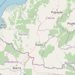
Map view of Munchique National Natural Park

Use this park location map to pinpoint Munchique National Natural Park in Colombia, understand its exact geographic position, and read its mapped placement within the surrounding landscape more clearly.

Pigeon | © OpenStreetMap contributors

Location context for Munchique National Natural Park

Cauca Department
Park atlas

Compare regional protected landscapes across Colombia's Andean Cordillera Occidental and Pacific drainage basin.

Explore Other National Parks and Protected Areas Near Munchique National Natural Park
After exploring Munchique National Natural Park, browse nearby national parks and other protected areas across the Cauca Department and Colombia's southwestern Andean region. Compare diverse cloud forest, paramo, and mountain ecosystems to trace broader conservation landscapes and regional park geography.
National parkCauca Department

Puracé National Natural Park: National Park Discovery and Geographic Context in Cauca Department

Explore its mapped protected landscape and regional natural geography.

Puracé National Natural Park offers a rich opportunity for geographic discovery within Colombia's Cauca Department. As a designated national park, its protected landscape serves as a key point of reference for understanding regional natural geography. This atlas-focused entry provides insight into the park's mapped boundaries and its significance as a protected area, facilitating a deeper comprehension of Colombia's conservation territories and natural terrain.

Area
830 km²
Established
1961
IUCN
II
Relief
Mountain
Watercolor painting of green hills, trees, and distant mountains under a light sky
National parkValle del Cauca Department

Farallones de Cali National Park: Protected Landscape and Geographic Atlas

Explore mapped boundaries and regional context.

Farallones de Cali National Park offers a distinct protected landscape within Valle del Cauca Department. This page provides atlas-level detail on its geographic scope and mapped features, crucial for understanding its regional context. Dive into the protected-area specifics to grasp the natural terrain and conservation landscape that defines this significant Colombian national park.

Area
1,500 km²
Established
1968
IUCN
II
Relief
Mountain
National parkNariño Department

Doña Juana-Cascabel Volcanic Complex National Natural Park: National Park with Mapped Protected Landscape

Explore its volcanic terrain and geographic context in Nariño Department.

Doña Juana-Cascabel Volcanic Complex National Natural Park is a designated National Park offering rich opportunities for geographic exploration. Situated within Nariño Department, this protected landscape provides a unique lens through which to study regional natural features and mapped conservation boundaries. Its presence within Colombia's protected areas network makes it a key point of reference for understanding national park geography and landscape context.

Area
0.267 km²
Established
2007
IUCN
II
Relief
Mountain
National parkValle del Cauca Department

Uramba Bahía Málaga National Natural Park: National Park Protected Landscape and Geography

Explore mapped natural terrain and protected boundaries.

Gain a detailed atlas understanding of Uramba Bahía Málaga National Natural Park, a designated national park in Colombia's Valle del Cauca Department. This page details its protected landscape features and geographic setting, offering insights into its mapped boundaries and regional context for dedicated geographic exploration.

Area
471 km²
Established
2010
IUCN
II
Climate
Tropical
Watercolor illustration of a mountain range with a lake in the foreground, green fields, and a colorful sky
Protected areaColombia

Galeras Protected Area: Exploring Colombia's Mapped Natural Landscapes

Discover the geography and protected terrain of Galeras.

The Galeras protected area in Colombia offers a distinct opportunity for geographic exploration, focusing on its defined boundaries and the natural landscape it encompasses. This resource details the park's setting within the Colombian geography, providing a map-centric view of its protected status. Understanding Galeras contributes to a broader appreciation of protected lands across South America and their unique terrain.

Relief
Mountain
Climate
Alpine
Access
Highly restricted
National parkColombia

Serranía de Los Churumbelos Auka-Wasi National Natural Park: Colombia's Protected Landscape Atlas

Mapped national park boundaries and regional geography.

Understand Serranía de Los Churumbelos Auka-Wasi National Natural Park through its geographic context and protected landscape features. This atlas view highlights the park's mapped boundaries and its significance within Colombia's natural geography, offering detailed insights into its protected status and regional terrain.

Area
562 km²
Established
2007
IUCN
II
Relief
Mountain
Watercolor painting of a lake with green hills and trees in the background
Protected areaNariño

La Corota Island Flora Sanctuary: A Unique Protected Area within Colombia's Nariño Region

Explore its Andean cloud forest landscape and mapped island geography.

La Corota Island Flora Sanctuary is a critical protected area in Nariño, Colombia, celebrated for its distinctive status as the country's only lake island ecosystem supporting old-growth Andean cloud forest. This compact sanctuary provides a unique landscape context, safeguarding endemic plant species and diverse birdlife within its mapped boundaries. Its presence within Laguna de la Cocha highlights a special convergence of wetland and forest geography, offering insights for atlas exploration of protected lands.

Area
0.152 km²
Established
1977
IUCN
II
Visitors
28K annual
National parkColombia

Tatamá National Natural Park: Colombia's Protected Natural Landscape Explorer

Mapped boundaries and regional geography of a Colombian national park.

Tatamá National Natural Park is a protected natural area situated within the Republic of Colombia. As a designated national park, it contributes significantly to the nation's protected lands. This entry provides essential geographic context, focusing on the park's mapped outlines and its role within the broader atlas of Colombian geography. Understanding Tatamá National Natural Park involves appreciating its specific landscape features and its contribution to the country's network of protected natural areas, offering a foundation for regional geographic study.

Area
519 km²
Established
1987
IUCN
II
Relief
Mountain

Common questions about visiting, size, designation, and location context for Munchique National Natural Park

Munchique National Natural Park FAQs for park facts, access, geography, and protected area context
Find quick answers about Munchique National Natural Park, including protected-area facts, park geography, trail and visitor context, and how the park fits into its surrounding country and regional landscape.
MoriAtlas Explorer

Continue Your Protected Areas Search Across the Global Atlas

Deepen your exploration by continuing the structured search for national parks and protected areas worldwide. Utilize the comprehensive filtering capabilities to compare different conservation landscapes and refine your understanding of global park geography. Discover more about the distribution and characteristics of protected natural areas.

Global natural geography