Mori Atlas logo
National parkÑacunday National Park

Trace the mapped boundaries and natural terrain of this protected national park entity.

Ñacunday National Park National Park: Discover Protected Landscape and Geographic Context in Paraguay

Ñacunday National Park stands as a significant protected landscape within Paraguay, designated as a national park. This page provides a focused atlas-style view of Ñacunday National Park, detailing its geographic setting and protected-area identity. Users can explore its mapped boundaries and understand its place within the regional geography of Paraguay, offering foundational discovery for landscape context and atlas exploration.

WaterfallAtlantic ForestSubtropical ForestProtected AreaNational ParkParaná River Basin

Ñacunday National Park

National park

Park overview

Structured park overview, official facts, and landscape profile for Ñacunday National Park

Ñacunday National Park park facts, protected area profile, and essential visitor context
Review the core facts for Ñacunday National Park, including designation, size, terrain, visitor scale, habitats, and operating context in one park-focused overview.

About Ñacunday National Park

Ñacunday National Park occupies a strategic position in eastern Paraguay's Alto Paraná department, protecting a significant remnant of the Atlantic forest that once covered vast stretches of the La Plata Basin region. The park's centerpiece, Salto Ñacunday, is a powerful waterfall where the Ñacunday River cascades over a rocky ledge roughly 900 meters before its confluence with the Paraná River. The waterfall's impressive dimensions, standing approximately 40 meters tall and 110 meters wide, make it Paraguay's most important waterfall and a symbol of the country's natural heritage. The protected area was originally established as the Ñacunday Protector Forest in 1975 through Decree No. 17,071, covering an initial area of 10 square kilometers that included the waterfall. The protection status was expanded and redesignated as Ñacunday National Park in 1993 under Decree No. 16,146, increasing the protected area to its current 20 square kilometers and incorporating the former Yacuy Protector Forest. This expansion reflected growing recognition of the area's ecological significance and the need to protect the watershed and forest ecosystems that sustain both wildlife and local communities.

Quick facts and research context for Ñacunday National Park

Located in the district of Ñacunday, Alto Paraná department, in eastern Paraguay between approximately 26°03' latitude and 54°42' longitude. The park covers 20 square kilometers and centers on the spectacular Salto Ñacunday waterfall. The climate is subtropical with well-distributed annual precipitation averaging 1,500 to 1,700 millimeters and a mean temperature of 21.5°C. The vegetation is primarily Alto Paraná Atlantic forest with two distinct forest layers, and the park protects a stretch of the Ñacunday River as well as multiple streams and water sources.

Park context

Deeper park guide and search-rich context for Ñacunday National Park

Ñacunday National Park history, landscape, wildlife, and travel context
Explore Ñacunday National Park through its history, landscape character, ecosystems, wildlife, conservation priorities, cultural context, and seasonal travel timing in a structured park guide built for atlas discovery and search intent.

Why Ñacunday National Park stands out

Ñacunday National Park is best known for Salto Ñacunday, the most significant waterfall in Paraguay following the historical loss of Salto del Guairá. The waterfall drops approximately 35 to 40 meters in height and stretches 110 meters in width, creating a dramatic natural landmark that attracts both domestic and international visitors. Beyond the waterfall, the park is notable for preserving a remnant of the Alto Paraná Atlantic forest, a critically endangered ecosystem that has been largely cleared for agriculture and logging across its historic range.

Ñacunday National Park history and protected-area timeline

The formal protection of Ñacunday began in 1975 when the Paraguayan government established the Ñacunday Protector Forest through Decree No. 17,071 on August 20 of that year. The initial protected area covered 10 square kilometers and was specifically created to preserve the Salto Ñacunday waterfall and its surrounding forest. At the time, Paraguay was beginning to develop a more systematic approach to protected area management, recognizing the ecological importance of its remaining forest cover. In 1993, the protection status was elevated and expanded through Decree No. 16,146, which redesignated the area as Ñacunday National Park and increased its total area to 20 square kilometers. This expansion also incorporated the neighboring Yacuy Protector Forest, creating a more comprehensive conservation unit. The legal changes reflected both increased understanding of the region's biodiversity value and growing public interest in preserving Paraguay's natural landmarks.

Ñacunday National Park landscape and geographic character

The park encompasses a varied landscape dominated by the Alto Paraná Atlantic forest, characterized by a layered canopy structure with emergent trees reaching 15 to 20 meters in the primary forest layer, while some species in the taller secondary forest can reach 35 meters. The terrain is shaped by the Ñacunday River, which has carved a path through the forest, creating the dramatic waterfall that serves as the park's focal point. Below the waterfall, an island has formed over time from accumulated woody debris cascading over the precipice. The landscape includes riparian zones along the river and numerous streams that feed the Ñacunday system, providing water to the surrounding area. The forest grows on soils typical of the Atlantic forest region, supporting dense vegetation across the park's terrain.

Ñacunday National Park ecosystems, habitats, and plant life

The vegetation of Ñacunday National Park represents the Alto Paraná Atlantic forests, one of the most threatened forest types in South America. The park contains two primary forest formations: a lower-stature forest dominated by species from the Meliaceae family including Argentine cedar (Cedrela fissilis) and catigua (Trichilla catigua), palmito palm (Euterpe edulis) from the Arecaceae family, and various Myrtaceae species such as ñangapiry (Eugenia enflora) and yvaporaity (Myrciaria rivularis). The taller forest layer features species from the Fabaceae family including yvyrá pytâ (Peltophorum dubium) and yvyrá ro (Pterogyne nitens), along with boraginaceous species like petereby (Cordia dichotoma) and Moraceae species including tatajyva (Chorolophora tinctoria) and amba'y (Cecropia pachystachya). The park also contains riparian forest along watercourses with smaller-statured species, as well as notable diversity of ferns and orchids. The climate supports this forest type through its subtropical character with abundant, well-distributed rainfall totaling 1,500 to 1,700 millimeters annually.

Ñacunday National Park wildlife and species highlights

The park supports diverse wildlife populations across multiple taxa including mammals, birds, rodents, and reptiles that inhabit the forest and surrounding areas. The Ñacunday River and its tributary streams provide habitat for a rich variety of fish species, particularly in the area where the river flows into the Paraná River. The river system itself forms an important aquatic corridor supporting species adapted to flowing water environments. While specific species counts are not detailed in available sources, the Atlantic forest ecosystem is known to support high biodiversity, and the protected area serves as a refuge for forest-dependent species in a region where much of the original habitat has been converted to agricultural use.

Ñacunday National Park conservation status and protection priorities

Ñacunday National Park plays a crucial role in preserving what remains of the Alto Paraná Atlantic forest, an ecoregion that has been dramatically reduced by deforestation across Paraguay, Brazil, and Argentina. The park protects a watershed that feeds the Ñacunday River, providing clean water to both wildlife and the Mbya Guaraní communities who live in the surrounding area. By protecting the waterfall and its forest surroundings, the park preserves a significant natural landmark while maintaining ecological connectivity in a heavily agricultural landscape. The national park status provides formal protection against logging, mining, and other extractive activities that have depleted the region's forest cover. The park also contributes to regional biodiversity conservation by maintaining habitat for species that depend on the Atlantic forest ecosystem.

Ñacunday National Park cultural meaning and human context

The Mbya Guaraní people have a deep connection to the Ñacunday area, with communities living both within and adjacent to the park boundaries. These indigenous peoples traditionally use the forest and river for essential activities including collecting firewood, harvesting honey, gathering fruits, and obtaining medicinal plants. The area serves as a natural environment for traditional Guaraní ceremonies, connecting the communities to their ancestral lands and spiritual practices. The Ñacunday River provides water for daily activities and is used for fishing and recreation. The surrounding landscape supports agricultural use by local communities, with some cattle ranching in the broader region. This living cultural context gives the park significance beyond its ecological value, representing a place where indigenous traditions continue to be practiced in relationship with the forest and waterfall.

Top sights and standout views in Ñacunday National Park

The centerpiece of Ñacunday National Park is the spectacular Salto Ñacunday waterfall, standing approximately 40 meters tall and 110 meters wide, the most important waterfall in Paraguay. The park protects a rare remnant of the Alto Paraná Atlantic forest, one of South America's most threatened forest ecosystems. The dramatic landscape combines forest-covered slopes with the powerful river cascade, creating a scenic environment that draws visitors seeking to experience Paraguay's natural heritage. The park also preserves important cultural connections through the presence of Mbya Guaraní communities who maintain traditional practices in the area.

Best time to visit Ñacunday National Park

The park can be visited year-round, though the subtropical climate means conditions vary across seasons. The summer months typically bring increased visitation, coinciding with the holiday period when Paraguayan tourists particularly favor the waterfall. The climate receives abundant rainfall throughout the year, with precipitation fairly evenly distributed, so visitors should be prepared for possible rain regardless of when they travel. The waterfall's flow is influenced by rainfall patterns in the upstream watershed, so visiting after periods of adequate rainfall will ensure the most impressive display. The warm climate with average temperatures around 21.5°C makes outdoor exploration comfortable for much of the year.
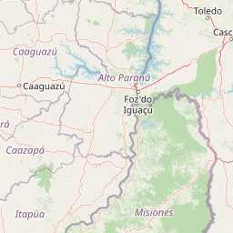

Park location guide

Geography guide, regional context, and park location map for Ñacunday National Park

Ñacunday National Park park geography, regions, and map view in Paraguay
Understand where Ñacunday National Park sits in Paraguay through a broader geographic reading of the surrounding landscape, nearby location context, and its mapped position within the national park landscape.

How Ñacunday National Park fits into Paraguay

Paraguay is a landlocked presidential republic in central South America with a population of approximately 6.4 million. Originally inhabited by the Guaraní people, it was colonized by Spain in the 16th century and gained independence in 1811. The country is notable for its strong Guarani cultural influence, economic growth driven by soybean and beef exports, and significant hydroelectric power generation. Asunción is both the capital and largest city.

Wider geography shaping Ñacunday National Park in Paraguay

Paraguay is located in the central region of South America, completely landlocked but with Atlantic Ocean access via the Paraná-Paraguay Waterway. It borders Bolivia to the northwest and north, Brazil to the northeast and east, and Argentina to the southeast, south, and west. The terrain consists mostly of rolling plains and lowlands, with the Paraguay River dividing the country into eastern and western regions.

Map view of Ñacunday National Park

Use this park location map to pinpoint Ñacunday National Park in Paraguay, understand its exact geographic position, and read its mapped placement within the surrounding landscape more clearly.

Pigeon | © OpenStreetMap contributors

Location context for Ñacunday National Park

Alto ParanáÑacunday
Park atlas

Compare diverse protected landscapes and their geographic spread across eastern Paraguay and the wider Atlantic forest ecoregion.

Explore National Parks and Protected Areas Near Ñacunday, Paraguay, and the Alto Paraná Region
Browse a curated list of national parks and other protected areas found throughout eastern Paraguay, offering further geographic context beyond Ñacunday National Park. Compare their unique conservation landscapes, trace regional ecological connections, and map the spread of protected zones in the Alto Paraná basin.
National parkMisiones Province

Iguazú National Park: Argentina's Misiones Province Protected Landscape Atlas

Explore mapped boundaries and regional geography.

Iguazú National Park serves as a key protected natural area situated within Misiones Province. This MoriAtlas entry details its mapped geographic boundaries, contributing essential context for understanding its landscape identity. Users can explore how this national park fits into the regional geography, providing a factual basis for detailed atlas-based study of protected lands and their unique terrain.

Area
677 km²
Established
1934
IUCN
II
Relief
Lowland
National parkItapúa Department

San Rafael National Park: National Park Protected Landscape & Geographic Overview

Discover the mapped boundaries and regional setting in Itapúa.

San Rafael National Park is a significant protected area designated as a national park in Paraguay's Itapúa Department. This page serves as an atlas-centric entry point, offering a detailed view of its geographic scope, mapped park boundaries, and its role as a conservation landscape. Users can explore the park's terrain and its place within the regional geography for a structured understanding of its protected status.

Area
693.04 km²
Established
1992
IUCN
II
Relief
Upland
National parkParaguay

Ypoá National Park: Paraguay's Protected Wetland Landscape and Lake Ecosystem

Explore mapped boundaries and significant bird habitats in the Ñeembucú region.

Ypoá National Park is a critical protected area in Paraguay, renowned for its extensive wetland ecosystems dominated by Lake Ypoá. This national park encompasses a rich mosaic of marshlands, riparian forests, and aquatic vegetation, making it a significant habitat for numerous bird species, including several rare and endemic types. Its designation as a Ramsar Wetland underscores its ecological importance, offering a unique lens for understanding landscape context and protected-area geography within South America.

Area
1,000 km²
Established
1992
IUCN
II
Relief
Lowland
National parkCorrientes Province

Iberá National Park: National Park Atlas Exploration in Corrientes Province

Mapped protected area context and regional geography.

Delve into the atlas view of Iberá National Park, a designated national park situated in Corrientes Province, Argentina. This detailed entry clarifies the park's protected landscape identity and its contribution to the regional geography of northeastern Argentina. Understand its mapped boundaries and explore its significance as a conservation area within the Mesopotamia region.

Area
1,835 km²
Established
2018
IUCN
II
Relief
Lowland
National parkFormosa Province

Río Pilcomayo National Park: Protected Humid Chaco Wetland Landscape & Geography

Explore mapped boundaries and unique floodplain terrain in Formosa Province.

Río Pilcomayo National Park represents a significant protected natural area within Argentina's Formosa Province, characterized by the unique ecosystems of the Humid Chaco. The park's landscape is defined by extensive floodplains, marshes, lakes, and forests, all influenced by the Pilcomayo River's dynamic hydrological cycle. As a Ramsar site, it safeguards crucial habitats, including those for the endangered jaguar, and showcases iconic Caranday palm savannas. This detailed atlas entry provides insights into its mapped geography and the vital protected landscape it preserves.

Area
518.89 km²
Established
1951
IUCN
II
Relief
Lowland
National parkCorrientes Province

Mburucuyá National Park: National Park in Corrientes Province, Argentina

Iconic yatay palm savannas and diverse wetland ecosystems.

As a key national park within Argentina's Corrientes Province, Mburucuyá National Park offers a unique atlas-scale view of ecological convergence. It preserves expansive yatay palm savannas, critical wetland habitats within the Iberá Wetlands, and lush subtropical forests. The park's boundaries define an area where the Humid Chaco, Espinal, and Selva Paranaense biomes meet, creating a landscape of exceptional biodiversity and geographic significance for regional conservation and mapped exploration.

Area
176.82 km²
Established
2001
IUCN
II
Relief
Lowland
National parkChaco Province

Chaco National Park: Protected Landscape and Regional Geography Atlas

Explore mapped boundaries within the Eastern Chaco's unique ecosystem.

Chaco National Park is an important protected area in Chaco Province, Argentina, dedicated to preserving the unique Eastern Chaco ecosystem. Covering 150 square kilometers, its landscape comprises warm lowland terrain with scrubland, savanna, swamp areas, and scattered lakes. This national park is recognized for its efforts to conserve the distinctive quebracho forests and supports a rich array of wildlife, making it a key site for understanding regional protected-area geography and landscape context.

Area
150 km²
Established
1954
IUCN
II
Relief
Lowland
National parkArgentina

El Impenetrable National Park: A Protected National Park within Argentina's Geography

Explore its mapped boundaries and regional landscape context.

Delve into El Impenetrable National Park, a designated national park situated in Argentina. This entry provides critical geographic context, detailing its mapped protected area boundaries and its role within the national landscape. Understand its unique regional setting and explore its significance as a protected natural space for atlas-based discovery.

Area
1,289 km²
Established
2014
Relief
Lowland
Climate
Subtropical

Common questions about visiting, size, designation, and location context for Ñacunday National Park

Ñacunday National Park FAQs for park facts, access, geography, and protected area context
Find quick answers about Ñacunday National Park, including protected-area facts, park geography, trail and visitor context, and how the park fits into its surrounding country and regional landscape.
MoriAtlas Explorer

Continue Your Protected Areas Search Across the Global Atlas

Deepen your exploration by continuing the structured search for national parks and protected areas worldwide. Utilize the comprehensive filtering capabilities to compare different conservation landscapes and refine your understanding of global park geography. Discover more about the distribution and characteristics of protected natural areas.

Global natural geography