

Mori Atlas logo
Nature reserveNadgee Nature Reserve

A vast protected area defined by eucalyptus forests, saltwater wetlands, and remote coastal terrain.

Nadgee Nature Reserve: Mapping the Coastal Wilderness and Protected Landscapes of New South Wales

Nadgee Nature Reserve occupies a remote coastal stretch in southeastern New South Wales, bordering Victoria at the Black-Allan Line. This protected area encompasses over 20,000 hectares of declared wilderness, featuring a transition from dry eucalyptus forests to sweeping coastal heathlands and tidal saltwater wetlands. The reserve serves as a vital ecological link within the Nadgee to Mallacoota Inlet Important Bird Area, providing essential habitat for species like the eastern bristlebird and pilotbird.

wilderness areacoastal reserveheathlandeucalyptus forestsaltwater wetlandsbirdlife

Nadgee Nature Reserve

Nature reserve

Park overview

Structured park overview, official facts, and landscape profile for Nadgee Nature Reserve

Nadgee Nature Reserve park facts, protected area profile, and essential visitor context

Review the core facts for Nadgee Nature Reserve, including designation, size, terrain, visitor scale, habitats, and operating context in one park-focused overview.

About Nadgee Nature Reserve

Nadgee Nature Reserve is a substantial protected area on the far south coast of New South Wales, defined by its wilderness-scale footprint, coastal ecosystems, and ecological linkage to Victorian parks just across the border. Covering roughly 20,671 hectares, the reserve is administered by the NSW National Parks and Wildlife Service and is classified internationally as a Category Ib wilderness area, indicating a high level of naturalness and minimal infrastructure. About 18,800 hectares of the reserve are formally declared wilderness, giving it one of the larger undeveloped coastal footprints in the region.

Geographically, the reserve adjoins Beowa National Park to the north and continues seamlessly into Croajingolong National Park in Victoria along the Black-Allan Line, the straight-line border between the two states. This positioning places Nadgee at the heart of a cross-border conservation landscape, allowing wildlife and ecological processes to function across jurisdictional boundaries.

The reserve is visited for activities such as bushwalking, cycling, swimming, fishing, and sea kayaking, reflecting its range of beach, forest, and estuarine settings. Its varied habitats, including dry eucalyptus forest, coastal heathland, and saltwater wetlands, support a broad range of mammal and bird species. Cultural significance is equally important, with shell middens, burial sites, and rock art along Wonboyn Beach attesting to long Aboriginal use of the coast by the Bidawal people. Together, these features make Nadgee a distinctive blend of wilderness, biodiversity, and cultural heritage on Australia's southeastern coastline.

Quick facts and research context for Nadgee Nature Reserve

Nadgee Nature Reserve covers about 20,671 hectares on the far south coast of New South Wales, near the town of Eden. It is classified as an IUCN Category Ib wilderness area and is managed by the NSW National Parks and Wildlife Service. Roughly 18,800 hectares of the reserve are declared wilderness.

The reserve lies directly south of Beowa National Park and abuts Croajingolong National Park in Victoria along the Black-Allan Line. Its vegetation combines dry eucalyptus forest, heathland, and saltwater wetlands, and includes Aboriginal cultural sites such as shell middens and burial areas along Wonboyn Beach.

Protection and recognition

Documented terrestrial protection scope and international recognition facts

Nadgee Nature Reserve Protection Status and Official Designation Records

Nadgee Nature Reserve holds a documented terrestrial protection scope within the official protected area registry. Structured records outline the baseline conservation designation parameters and available international recognition frameworks.

Protection details

Protection scope
Terrestrial
Park context

Deeper park guide and search-rich context for Nadgee Nature Reserve

Nadgee Nature Reserve history, landscape, wildlife, and travel context

Explore Nadgee Nature Reserve through its history, landscape character, ecosystems, wildlife, conservation priorities, cultural context, and seasonal travel timing in a structured park guide built for atlas discovery and search intent.

Why Nadgee Nature Reserve stands out

Nadgee Nature Reserve is best known for its large declared wilderness area on the New South Wales far south coast and its role as a habitat stronghold for heath-dependent and coastal bird species. It is part of the Nadgee to Mallacoota Inlet Important Bird Area, recognized by BirdLife International for supporting populations of eastern bristlebirds and pilotbirds, as well as other significant fauna. It is also known for its Aboriginal heritage, particularly along Wonboyn Beach where shell middens, art sites, and burial locations reflect long Bidawal presence. Combined with eucalyptus forest, heath, and saltwater wetland habitats, these qualities give the reserve a distinctive mix of cultural depth and ecological character that complements neighboring protected areas across the state border.

Nadgee Nature Reserve history and protected-area timeline

The area now protected as Nadgee Nature Reserve has a long human history stretching back to the Bidawal Aboriginal people, who inhabited the landscape around what is today the far south coast of New South Wales. Their presence is still visible in the reserve through shell middens distributed along the coastline, as well as art and burial sites located at Wonboyn Beach. These sites reflect sustained use of marine and coastal resources over many generations.

European contact with the area is unusually well documented. Survivors of the shipwreck Sydney Cove passed through the region in 1797 and encountered members of the Bidawal tribe on 29 March 1797 while making their way back to Sydney. After this early encounter, European impact on the landscape remained relatively limited for well over a century. Only two farms, with their surrounding acreage, were cultivated within the broader area, leaving large portions of the coast and forest in a largely undisturbed state.

In 1954, Allen Strom, Allan Fox, and Charles Witheford proposed the gazetting of a reserved area to formal recognition of the site's natural values. The New South Wales Government responded in 1957 by declaring the land as the Nadgee Faunal Reserve, establishing the protected status that continues today. The reserve grew during the 1970s with the addition of the upper catchment of the Nadgee River, an area that had recently been logged, extending protection across an important inland watershed and reinforcing the reserve's ecological coherence.

Nadgee Nature Reserve landscape and geographic character

Nadgee Nature Reserve occupies a coastal position on the far south coast of New South Wales, with a landscape shaped by the meeting of forest, heath, and sea. The reserve's terrain includes dry eucalyptus forest on the better-drained inland soils, sweeping expanses of low coastal heathland, and saltwater wetlands associated with estuaries and tidal flats. Together, these environments give the reserve a varied visual character, from dense woodland stretches to open heath ridges and quiet coastal waterbodies.

The reserve's coastline is a defining feature, with Wonboyn Beach as a notable landmark within the protected area. Nearby estuarine systems and saltwater wetlands create a transitional zone between the forested interior and the ocean, adding to the diversity of habitats present. Much of this landscape was reshaped by significant bushfires, beginning with a lightning strike in 1972 and a logging burn-off in 1980, which altered vegetation structure and set the stage for the regrowth that defines much of the reserve today.

To the south, the Black-Allan Line forms a near-straight boundary that runs across the landscape and links Nadgee visually and ecologically with Croajingolong National Park in Victoria. This gives the reserve a transboundary quality, where the coastal scenery continues across state lines and reinforces the impression of an unbroken natural coastline at the southeastern edge of the Australian continent.

Nadgee Nature Reserve ecosystems, habitats, and plant life

The ecological character of Nadgee Nature Reserve is built on three principal habitat types: dry eucalyptus forest, low coastal heathland, and saltwater wetlands. These habitats form a mosaic across the reserve's roughly 20,671 hectares, with each supporting distinct plant and animal communities. Fire has played a major role in shaping the present-day condition of the vegetation, with major bushfires in 1972 and 1980 resetting substantial areas and driving subsequent regeneration.

The dry eucalyptus forest provides a wooded matrix across much of the inland reserve, while the heathland areas contribute species-rich shrub communities typical of the far south coast. Saltwater wetlands along estuarine margins add another ecological dimension, supporting species adapted to brackish conditions and offering feeding habitat for waterbirds and other fauna. The combination of fire ecology, vegetation diversity, and habitat transitions gives the reserve a dynamic ecological profile.

Recognition of the reserve's ecological importance extends beyond state borders. The reserve lies within the Nadgee to Mallacoota Inlet Important Bird Area, identified by BirdLife International for its significant populations of heathland and forest bird species. This designation positions the reserve as part of a broader cross-border ecological network, alongside nearby Victorian parks.

Nadgee Nature Reserve wildlife and species highlights

Wildlife at Nadgee Nature Reserve reflects the diversity of its forest, heath, and wetland habitats. Mammals present in the reserve include swamp wallabies, eastern grey kangaroos, common wombats, agile antechinus, dusky antechinus, and sugar gliders, spanning ground-dwelling grazers, burrowers, and small arboreal marsupials. This range of mammal groups indicates a functional predator-prey and habitat mosaic spanning woodland and heath.

Birdlife is a standout feature of the reserve, with 34 species already recorded within the heathland areas alone. Notable species include the sooty owl, eastern ground parrot, little tern, and the endangered eastern bristlebird, alongside pilotbirds and other significant fauna. The presence of eastern bristlebirds, in particular, has driven international recognition of the area through its inclusion in the Nadgee to Mallacoota Inlet Important Bird Area.

The reserve's mixed habitats support a layered bird community, from ground-dwelling heathland specialists to canopy and nocturnal forest species. This bird assemblage contributes substantially to the reserve's conservation profile and supports its role as a key biodiversity area on the New South Wales far south coast.

Nadgee Nature Reserve conservation status and protection priorities

Nadgee Nature Reserve holds significant conservation value, recognized formally by its IUCN Category Ib wilderness area designation, reflecting a high degree of naturalness and minimal human infrastructure across most of its area. With about 18,800 hectares of declared wilderness, the reserve ranks among the more strictly protected coastal landscapes in New South Wales and provides a refuge for species that depend on large, undisturbed habitat blocks.

Its inclusion in the Nadgee to Mallacoota Inlet Important Bird Area underscores its role in safeguarding populations of eastern bristlebirds, pilotbirds, and other significant fauna. The reserve's heathland habitats, in particular, support a rich bird community, and protection of these areas is central to maintaining viable populations of species of conservation concern along the far south coast.

The reserve also forms a critical link in a cross-border conservation landscape, adjoining Beowa National Park to the north in New South Wales and Croajingolong National Park to the south in Victoria, with the Black-Allan Line as the shared boundary. This connectivity enhances ecological resilience, supports wildlife movement, and strengthens the long-term conservation outlook for species whose ranges span state borders.

Nadgee Nature Reserve cultural meaning and human context

Nadgee Nature Reserve forms part of the traditional country of the Bidawal Aboriginal people, who inhabited the area long before formal European contact. Their sustained presence is recorded through numerous shell middens distributed along the reserve's coastline, reflecting long-term reliance on marine and estuarine resources. Additional cultural elements include art sites and burial locations associated with Wonboyn Beach, which remain significant places within the reserve.

European contact with the Bidawal in this region is unusually well documented in Australian history. Survivors of the 1797 Sydney Cove shipwreck encountered members of the Bidawal tribe as they made their way northward to Sydney, recording an early and detailed cross-cultural encounter on what is now the reserve's coastline. This event gives the area a distinctive place in the early contact history of southeastern Australia.

Following that encounter, the broader region experienced comparatively little European modification, with only two farms and adjoining acreage cultivated within the wider area. This limited historical land use contributed to the survival of both Aboriginal cultural sites and the natural landscapes that underpin the reserve's present-day ecological and cultural values.

Top sights and standout views in Nadgee Nature Reserve

Nadgee Nature Reserve's strongest features include its declared wilderness status across most of its area, its position within the Nadgee to Mallacoota Inlet Important Bird Area, and the adjoining cross-border continuity with Croajingolong National Park in Victoria. The reserve's combination of eucalyptus forest, coastal heath, and saltwater wetland habitats supports a notably rich mammal and bird community, including the endangered eastern bristlebird and the pilotbird.

Equally distinctive are the reserve's cultural features, with shell middens, burial sites, and rock art along Wonboyn Beach linking the protected area directly to the long Aboriginal heritage of the Bidawal people. Together with early European contact history from the Sydney Cove survivors in 1797, these cultural layers add a depth of context that complements the reserve's natural values.

Best time to visit Nadgee Nature Reserve

The character of a visit to Nadgee Nature Reserve varies with season in ways typical of the far south coast of New South Wales. The cooler months generally bring calmer conditions and clearer, crisper days that suit longer bushwalking and birdwatching along the heathland and forest tracks. This period can also be rewarding for spotting heath-dependent birds, including the eastern bristlebird and pilotbird, when cool, settled weather keeps activity high in the open habitats.

Warmer months bring softer atmospheric conditions, wildflowers in the heath communities, and a more active beach and estuary environment for swimming, fishing, and sea kayaking. Because much of the reserve was shaped by significant past bushfires, regenerating vegetation continues to evolve through the seasons, lending different aspects to the landscape depending on the time of year. Visitors should be mindful of local conditions, especially during periods of elevated fire risk on the south coast.
Monthly climate preview

Long-term monthly temperature averages and precipitation records for Nadgee Nature Reserve

Nadgee Nature Reserve Climate Normals and Annual Temperature Patterns

Historical climate data for Nadgee Nature Reserve records monthly average temperatures spanning from 12.21 degrees Celsius to 20.10 degrees Celsius alongside measured daily precipitation rates. Examining the full twelve-month profile reveals detailed baseline climate rhythms sampled across representative park coordinates.
Annual mean16 °C
12 °C20 °C
Jan20°
Feb20°
Mar19°
Apr17°
May15°
Jun13°
Jul12°
Aug12°
Sep14°
Oct15°
Nov16°
Dec18°
Warmest month
February

20.1 °C

Coolest month
July

12.2 °C

Wettest month
November

3 mm/day

Driest month
August

1.8 mm/day

Park location guide

Geography guide, regional context, and park location map for Nadgee Nature Reserve

Nadgee Nature Reserve park geography, regions, and map view in Australia

Understand where Nadgee Nature Reserve sits in Australia through a broader geographic reading of the surrounding landscape, nearby location context, and its mapped position within the national park landscape.

How Nadgee Nature Reserve fits into Australia

Australia is a constitutional monarchy and federal parliamentary democracy comprising six states and ten territories. With a population of nearly 28 million, it is one of the world's most urbanised countries, with most people concentrated on the eastern seaboard. The country has a high Human Development Index and is known for its cultural diversity, ancient Aboriginal heritage, and unique wildlife.

Wider geography shaping Nadgee Nature Reserve in Australia

Australia occupies the entire Australian continent, the island of Tasmania, and numerous smaller islands. It is the world's flattest and driest inhabited continent, featuring vast deserts in the interior (the Outback), tropical rainforests along the eastern coast, and a coastline bordering the Indian and Pacific Oceans.

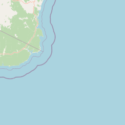
Map view of Nadgee Nature Reserve

Use this park location map to pinpoint Nadgee Nature Reserve in Australia, understand its exact geographic position, and read its mapped placement within the surrounding landscape more clearly.

Pigeon | © OpenStreetMap contributors

Location context for Nadgee Nature Reserve

New South Wales
Park atlas

Compare surrounding coastal landscapes and regional conservation areas

Other Parks and Protected Areas Near Nadgee Nature Reserve

Browse nearby national parks and protected areas sharing the coastal terrain of Nadgee Nature Reserve. Comparing adjacent regional reserves helps trace continuous wildlife corridors and forest habitats across state borders.
National parkNew South Wales
About 6.7 km away#1 closest

North

Beowa National Park: Protected Landscape and Coastal Geography in New South Wales

Mapped terrain and unique erosion sites within this national park.

Delve into the protected landscape of Beowa National Park, situated in the coastal region of New South Wales. This national park showcases a varied terrain, from heathland headlands to eucalypt woodlands, with the visually dramatic Pinnacles erosion gully as a key highlight. Its geographic setting within Twofold Bay provides a compelling focus for atlas exploration of Australia's protected natural areas.

Area
104.86 km²
Established
1971
IUCN
II
Relief
Lowland
National parkAustralia
About 19 km away#2 closest

South

Croajingolong National Park: A UNESCO World Biosphere Reserve with Dramatic Coastal Geography

Explore Victoria's protected wilderness, mapped coastlines, and diverse ecosystems.

Croajingolong National Park is a key protected area in Victoria, Australia, recognized globally as a UNESCO World Biosphere Reserve. This vast national park offers a detailed look at coastal wilderness, characterized by its extensive sandy beaches, rugged rocky headlands, dynamic dunes, and rich heathland ecosystems. Its position along the Tasman Sea coastline provides significant geographic context, forming a vital part of southeastern Australia's protected landscapes and offering unique opportunities for atlas-driven exploration of its mapped terrain and biodiversity.

Area
883.55 km²
Established
1979
IUCN
II
Relief
Mixed relief
National parkNew South Wales
About 20 km away#3 closest

Northwest

Mount Imlay National Park: Protected Land Geography and Mapped Boundaries in New South Wales

Explore the geographic context of this Australian national park.

Mount Imlay National Park serves as a significant protected area within New South Wales, providing a focal point for understanding regional geography and mapped natural landscapes. As a national park, its boundaries and terrain offer valuable insights for atlas-based discovery, highlighting Australia's commitment to conserving diverse geographic entities and showcasing its role in the broader national landscape context.

Area
48 km²
Established
1972
IUCN
II
Relief
Mountain
Marine protected areaAustralia
About 23 km away#4 closest

South

Cape Howe Marine National Park: Victoria's Southeastern Marine Protected Landscape

Rugged coast, Southern Ocean influence, and marine conservation.

Cape Howe Marine National Park offers a protected marine environment at the remote eastern edge of Victoria, Australia. Defined by its dramatic coastal geography, the park features rocky headlands, exposed cliffs, and waters influenced by the powerful Southern Ocean. Established in 2002, this marine protected area contributes to a significant continuum of protected lands, adjacent to terrestrial national parks. Its landscape is shaped by powerful surf and coastal wilderness, providing a unique example of marine conservation where the Australian continent meets the open ocean.

Area
40.5 km²
Established
2002
IUCN
II
Climate
Temperate
National parkNew South Wales
About 23 km away#5 closest

Northwest

South East Forests National Park: New South Wales National Park Atlas Entry

Mapped landscape and protected area geography.

This canonical MoriAtlas entry for South East Forests National Park provides essential geographic context and details about its status as a national park. Understand the mapped boundaries of this protected landscape within New South Wales, supporting discovery through its regional setting and natural terrain. The focus remains on atlas-style exploration of its geographic identity and conservation significance, devoid of visitor logistics or travel advice.

Area
1,151.77 km²
Established
1997
IUCN
II
Relief
Highland
Nature reserveNew South Wales
About 25 km away#6 closest

North

Eagles Claw Nature Reserve: Mapping Coastal Protected Landscapes in New South Wales

Coastal terrain, sea gutters, and penguin nesting habitat

Eagles Claw Nature Reserve is a distinctive protected area on the NSW far south coast, known for its rugged shoreline of sea gutters and low cliffs. The site features dense coastal scrub dominated by bracelet honey myrtle, providing essential nesting shelter for little penguins. This atlas overview details the reserve's topography and its function as a vital coastal sanctuary.

Area
0.01 km²
Established
1986
IUCN
IV
Relief
Lowland
National parkAustralia
About 40 km away#7 closest

West

Coopracambra National Park: Remote Mountainous Protected Landscape in Victoria

Explore its transboundary wilderness role and tall forest terrain.

Coopracambra National Park stands as a significant protected landscape in Victoria, Australia, renowned for its rugged mountainous terrain and extensive tall eucalypt forests. This remote national park serves as the crucial Victorian component of a vast transboundary wilderness corridor, linking protected areas across the state border into New South Wales. Its geographic identity is shaped by prominent peaks such as Mount Coopracambra and the unique Black-Allan Line boundary, offering users a detailed atlas view of its conservation significance and natural features within south-eastern Australia.

Area
388 km²
Established
1988
IUCN
II
Relief
Mountain
Watercolor illustration showing a coastal landscape with green hills, blue water, and distant mountains
National parkNew South Wales
About 51 km away#8 closest

North

Bournda National Park: A Protected National Park in New South Wales

Explore mapped boundaries and regional geographic context.

Bournda National Park represents a key protected area within the state of New South Wales, Australia. This page offers focused discovery of its protected landscape identity, situated within the broader geographic framework of the region. Examine the park's mapped boundaries and understand its significance as a component of Australia's network of natural landscapes.

Area
26.55 km²
Established
1947
IUCN
II
Relief
Lowland

Common questions about visiting, size, designation, and location context for Nadgee Nature Reserve

Nadgee Nature Reserve FAQs for park facts, access, geography, and protected area context

Find quick answers about Nadgee Nature Reserve, including protected-area facts, park geography, trail and visitor context, and how the park fits into its surrounding country and regional landscape.
MoriAtlas Explorer

Continue Your Protected Areas Search Across the Global Atlas

Deepen your exploration by continuing the structured search for national parks and protected areas worldwide. Utilize the comprehensive filtering capabilities to compare different conservation landscapes and refine your understanding of global park geography. Discover more about the distribution and characteristics of protected natural areas.

Global natural geography