Mori Atlas logo
Protected areaNam Kading National Protected Area

A detailed atlas of river corridors, forested mountain ranges, and protected terrain in Bolikhamsai Province

Nam Kading National Protected Area: Mapping the Rugged Mountain Landscapes of Central Laos

Nam Kading National Protected Area represents a significant wilderness spanning over 1,600 square kilometres of central Laos. The landscape is defined by the deep-carved valleys of the Nam Kading river and its major tributaries, including the Nam Muan, Nam Sat, and Nam Tek. Ranging from lowland river floors at 140 metres to the 1,514-metre peak of Phou Pa Paek, this rugged terrain serves as a vital forest corridor within the Bolikhamsai Province.

national protected areaBolikhamsai Provincecentral Laosriver corridorNam Kading riverMekong tributary

Nam Kading National Protected Area

Protected area

Park overview

Structured park overview, official facts, and landscape profile for Nam Kading National Protected Area

Nam Kading National Protected Area park facts, protected area profile, and essential visitor context

Review the core facts for Nam Kading National Protected Area, including designation, size, terrain, visitor scale, habitats, and operating context in one park-focused overview.

About Nam Kading National Protected Area

Nam Kading National Protected Area is a large, mountainous, forest-dominated protected landscape in central Laos. Established in 1993, it preserves a tract of rugged terrain through which the Nam Kading, a significant tributary of the Mekong, runs from south to north. The park's administrative footprint stretches across several districts of Bolikhamsai Province, and the area is among the more substantial national protected areas in the country.

The defining character of Nam Kading is its wildness. Its steep ridges, deeply incised river valleys, and limited road access have allowed native forests to remain dominant across roughly 84 percent of the park. Evergreen forest and dry mixed deciduous forest form the principal vegetation types, and surveys have documented more than 250 plant species, including rare taxa such as Lagerstroemia balansae and Justicia gendarussa. Elevations vary dramatically, from low valley floors around 140 metres to the high ridge of Phou Pa Paek at more than 1,500 metres, producing a layered mosaic of habitats.

Ecologically, Nam Kading is a refuge for many of the signature large mammals and birds of mainland Southeast Asia. Both the northern and southern white-cheeked gibbon are present, alongside sun bear, gaur, tiger, Asian elephant, and the elusive giant muntjac. The area also supports impressive hornbills, including great hornbill, rufous-necked hornbill, and wreathed hornbill, as well as green peafowl and the Vietnamese crested argus. Among its birdlife, the pale-capped pigeon is of particular interest, as within Laos it appears to occur nowhere else.

The protected area's position at the intersection of rich biodiversity and major regional hydropower planning gives it a distinctive story. While the Nam Theun 2 Dam lies just to the south, in Khammouane Province, the Theun-Hinboun and the proposed Nam Theun 1 projects have had, or would have, direct consequences for the river flows, habitats, and accessibility of the park. These pressures, combined with ongoing hunting pressure from local communities, frame Nam Kading as both a high-value conservation area and a working example of the trade-offs facing protected areas in Laos.

Quick facts and research context for Nam Kading National Protected Area

Nam Kading National Protected Area lies in Bolikhamsai Province in central Laos, roughly 40 kilometres east of the town of Paksan and adjacent to the settlement of Pakkading. It was designated in October 1993 as a National Biodiversity Conservation Area and is currently managed under IUCN category VI, recognizing both its conservation value and the sustainable use of its natural resources.

The protected area covers approximately 1,600 square kilometres of forested mountain terrain, with native forest occupying the great majority of its surface. The landscape is dominated by the Nam Kading river basin and ranges in elevation from around 140 metres in the valleys to over 1,500 metres at Phou Pa Paek. Surveys have catalogued at least 43 mammal species and over 230 bird species, including several globally threatened species and one bird known in Laos only from Nam Kading.

Protection and recognition

Examine the documented terrestrial protection scope and conservation management context.

Nam Kading National Protected Area Protection Status and International Recognition

Nam Kading National Protected Area holds a terrestrial protection scope within the regional conservation network. Review the structured administrative records and official designation details associated with this protected landscape.

Protection details

Protection scope
Terrestrial
Park context

Deeper park guide and search-rich context for Nam Kading National Protected Area

Nam Kading National Protected Area history, landscape, wildlife, and travel context

Explore Nam Kading National Protected Area through its history, landscape character, ecosystems, wildlife, conservation priorities, cultural context, and seasonal travel timing in a structured park guide built for atlas discovery and search intent.

Why Nam Kading National Protected Area stands out

Nam Kading is best known for its combination of rugged, largely roadless terrain and an unusually intact forest ecosystem along the Nam Kading river corridor. The protected area stands out for its populations of white-cheeked gibbons, large hornbills, and other threatened species of mainland Southeast Asia, and for the rare pale-capped pigeon, which in Laos is recorded only here. It is also notable as one of the clearest examples in Laos of how a protected landscape with great biodiversity value can sit directly within a major hydropower development corridor, with the Nam Theun 2, Theun-Hinboun, and proposed Nam Theun 1 projects all shaping its environmental future.

Nam Kading National Protected Area history and protected-area timeline

The origins of Nam Kading National Protected Area lie in a series of biological surveys that began in 1989. Air and ground surveys were used to assess the region's forest cover, wildlife, and overall conservation value, and by 29 October 1993 the area was formally decreed as a National Biodiversity Conservation Area under the national protected area system of Laos.

Following designation, additional survey work began in 1995 to evaluate the potential impact of two hydropower proposals, the Theun-Hinboun project and the larger Nam Theun 1 project, on the protected area's ecosystems. These assessments helped document the park's flora and fauna and shaped early understanding of how energy infrastructure along the Nam Kading river could interact with conservation management. Since then, the park has remained an IUCN category VI protected area, reflecting both its biodiversity importance and the role of natural resource use within and around its boundaries.

Nam Kading National Protected Area landscape and geographic character

The landscape of Nam Kading is shaped first and foremost by rivers and the mountains they have carved. The Nam Kading flows from south to north through the centre of the park, gathering tributaries along the way and finally joining the Mekong beyond the protected area's northern edge. Together with the Nam Muan, Nam Sat, and Nam Tek rivers, the Nam Kading has eroded deep valleys that divide the park into four clearly defined mountain ranges.

The topography is highly variable. Lowland valley floors around 140 metres give way, often abruptly, to forested ridges and steep slopes. The highest point in the park is Phou Pa Paek, reaching roughly 1,514 metres. The result is a rugged, often inaccessible interior with limited road infrastructure, dramatic relief, and a strong vertical structuring of habitats. Karst-like ridges, dense forest cover, and the persistent presence of the Nam Kading and its tributaries define the visual and physical character of the area, distinguishing it from many of the lower-lying protected landscapes elsewhere in Laos.

Nam Kading National Protected Area ecosystems, habitats, and plant life

Nam Kading's natural wealth rests on its extensive native forests, which cover about 84 percent of the park. The two principal forest types are evergreen forest and dry mixed deciduous forest, with vegetation patterns shaped largely by elevation, soils, and the proximity to the Nam Kading and its tributaries. Botanical surveys linked to hydropower impact studies recorded more than 250 plant species, including rare species such as Lagerstroemia balansae and Justicia gendarussa.

Ecologically, the park functions as a connected forest block at the heart of central Laos, linking upland habitats with lowland riverine environments along the Nam Kading. Its extensive forest cover, combined with limited human settlement, has supported a relatively intact community of large mammals and forest-interior birds. The elevation gradient across the park also creates layers of habitat, from riverbank and lowland forest through mid-elevation deciduous stands to higher ridge and montane forest near Phou Pa Paek, allowing a broader range of species to coexist within a single protected area.

Nam Kading National Protected Area wildlife and species highlights

The wildlife of Nam Kading is among its most distinctive features. Surveys have catalogued at least 43 mammal species and 234 bird species. Mammal highlights include both northern and southern white-cheeked gibbons, sun bear, gaur, tiger, Asian elephant, and the giant muntjac, a smaller deer found in parts of Southeast Asia's forests. These species together reflect the park's role as a refuge for many of the region's most threatened large mammals.

Birdlife is particularly rich in hornbills and forest-dependent species. Endangered and notable birds include the great hornbill, rufous-necked hornbill, green peafowl, and Vietnamese crested argus, while more widely distributed species such as wreathed hornbill, wire-tailed swallow, river lapwing, sooty babbler, and rufous-throated fulvetta are also present. Of special biogeographical interest is the pale-capped pigeon, which within Laos has been recorded only at Nam Kading, giving the park a unique share of regional bird diversity.

Nam Kading National Protected Area conservation status and protection priorities

Nam Kading's conservation significance lies in its combination of large size, high forest cover, and the presence of multiple globally threatened species in a still largely undisturbed setting. The park's IUCN category VI status recognizes both its natural values and the continued role of resource use within and around its boundaries, but its long-term integrity depends heavily on managing external pressures.

The chief conservation concerns are tied to hydropower development and hunting. The Theun-Hinboun project has already altered flows on the Nam Kading, while further proposed projects have raised concerns about habitat fragmentation, biodiversity loss, flooding of forested areas, and increased human access to the park interior. At the same time, wildlife hunting by local communities represents an ongoing threat that could intensify as new roads or boat routes open up previously difficult terrain. Together these pressures frame Nam Kading as a high-priority area where conservation planning, energy policy, and local livelihoods intersect.

Nam Kading National Protected Area cultural meaning and human context

The cultural context of Nam Kading is closely tied to the rural communities of Bolikhamsai Province and the broader traditions of central Laos. Because the interior of the park is rugged and largely inaccessible, it has historically supported very limited permanent settlement, and the surrounding districts of Paksan, Pakkading, Borikhane, and Khamkeut have remained more closely tied to lowland river and farming landscapes along the Nam Kading and the Mekong.

Local communities have a meaningful relationship with the park through hunting, gathering, fishing, and other forms of natural resource use, which is reflected in the area's IUCN category VI designation. This ongoing human presence, alongside the park's ecological value, shapes the broader conversation about how protection, traditional livelihoods, and energy infrastructure can coexist in central Laos.

Top sights and standout views in Nam Kading National Protected Area

Nam Kading stands out for the unusual combination of large size, intact forest cover, and rugged terrain along one of Laos's most important river tributaries. Its populations of white-cheeked gibbons, large hornbills, tiger, elephant, and gaur place it among the most biologically rich protected areas in central Laos, while the pale-capped pigeon gives it a unique biogeographical signature.

Equally significant is the park's role at the intersection of conservation and hydropower development on the Nam Kading river system. The interplay between the existing Theun-Hinboun project, the upstream Nam Theun 2 Dam, and the proposed Nam Theun 1 project makes Nam Kading a defining case study in how a high-value protected area can be managed within a region shaped by large-scale water infrastructure.

Best time to visit Nam Kading National Protected Area

The character of a visit to Nam Kading is strongly shaped by the seasonal rhythm of central Laos. The dry season, generally spanning the cooler months from roughly November through February, brings lower river levels, more stable weather, and clearer forest conditions that are well suited to river-based travel along the Nam Kading and to birdwatching, when many species are easier to observe in the more open deciduous forest.

The warmer months leading into the wet season, around March to May, bring rising temperatures and increasingly humid conditions, while the monsoon period from roughly May or June through October fills the Nam Kading and its tributaries, raises river levels dramatically, and makes the rugged interior even more difficult to access. Travelers interested in lush forest, waterfalls, and high water scenery often favor this period, though remote areas of the park become harder to reach.

Monthly climate preview

Long term temperature and precipitation normals recorded across twelve representative months

Nam Kading National Protected Area Climate And Weather By Month

Representative coordinate records show measured variations in monthly mean temperatures and daily precipitation totals throughout the year at Nam Kading National Protected Area. Reviewing complete monthly climate normals helps analyze long term weather patterns and regional meteorological conditions in greater detail.
Annual mean22 °C
16 °C25 °C
Jan16°
Feb19°
Mar23°
Apr25°
May25°
Jun25°
Jul24°
Aug24°
Sep24°
Oct22°
Nov19°
Dec16°
Warmest month
May

25.3 °C

Coolest month
December

16 °C

Wettest month
August

10.1 mm/day

Driest month
January

0.5 mm/day

Park location guide

Geography guide, regional context, and park location map for Nam Kading National Protected Area

Nam Kading National Protected Area park geography, regions, and map view in Laos

Understand where Nam Kading National Protected Area sits in Laos through a broader geographic reading of the surrounding landscape, nearby location context, and its mapped position within the national park landscape.

How Nam Kading National Protected Area fits into Laos

Laos, officially the Lao People's Democratic Republic, is a unitary communist state in mainland Southeast Asia. As the only landlocked country in the region, it shares borders with Myanmar, China, Vietnam, Cambodia, and Thailand. The country has a population of over 7 million and is known for its mountainous terrain, Buddhist heritage, and three UNESCO World Heritage Sites: Luang Prabang, Vat Phou, and the Plain of Jars. The Boten, Vientiane railway completed in 2021 connects Laos to China.

Wider geography shaping Nam Kading National Protected Area in Laos

Laos is located in mainland Southeast Asia, occupying a mountainous and forested landscape. It is bordered by Myanmar and China to the northwest, Vietnam to the east, Cambodia to the southeast, and Thailand to the west and southwest. As the only landlocked country in Southeast Asia, it has no coastline. The country lies at approximately 17.967°N latitude and 102.6°E longitude.

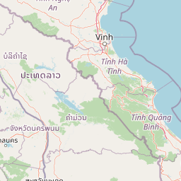
Map view of Nam Kading National Protected Area

Use this park location map to pinpoint Nam Kading National Protected Area in Laos, understand its exact geographic position, and read its mapped placement within the surrounding landscape more clearly.

Pigeon | © OpenStreetMap contributors

Location context for Nam Kading National Protected Area

Bolikhamsai Province
Park atlas

Compare adjacent river corridors, rugged forest terrain, and connected central regional habitats

Parks Near Nam Kading National Protected Area and Surrounding Regional Protected Landscapes

Browsing other protected areas near Nam Kading National Protected Area reveals broader regional patterns in remote forest conservation and river basin geography. Comparing adjacent mountain ecosystems helps place rugged central landscapes and watershed reserves into a wider geographical perspective.
National parkNghệ An Province
About 78 km away#1 closest

Northeast

Pù Mát National Park: National Park Protected Landscape and Geographic Mapping

Explore Nghệ An Province's protected area context.

Pù Mát National Park is a key protected area situated in Nghệ An Province, Vietnam. This entry focuses on its role as a national park, detailing its mapped boundaries and geographic features. It serves as a vital point for understanding the distribution of protected lands and the natural landscape context within the broader regional atlas. Discover the specific geographic identity and atlas significance of Pù Mát National Park.

Area
911.13 km²
Established
2001
IUCN
II
Relief
Mountain
Wildlife reserveKhammouane Province
About 89 km away#2 closest

Southeast

Phou Hin Poun National Biodiversity Conservation Area: Khammouane Province Landscapes

Tower karst geology and Annamite Range biodiversity

Delve into the geography of Phou Hin Poun National Biodiversity Conservation Area, where dramatic stone ridges and dense forest patches define a unique karst ecosystem. Located in Khammouane Province, this wildlife reserve stands as a major center for scientific discovery and protected habitat monitoring in central Laos.

Area
1,801.49 km²
Established
1993
IUCN
VI
Relief
Mountain
National parkHà Tĩnh Province
About 124 km away#3 closest

East

Vũ Quang National Park: Protected Landscape Identity and Geographic Context in Hà Tĩnh

National Park Discovery and Mapped Terrain Exploration

Investigate Vũ Quang National Park, a key protected area situated in Hà Tĩnh Province. This page provides detailed insight into the park's designation as a national park, focusing on its mapped boundaries, surrounding natural landscapes, and contribution to the regional geography. It serves as a vital resource for understanding the park's protected landscape characteristics and its place within Vietnam's atlas of conservation areas.

Area
550.28 km²
Established
2002
IUCN
II
Relief
Mountain
National parkSakon Nakhon Province
About 152 km away#4 closest

South

Phu Phan National Park: Thailand's Protected Mountain Landscape and Natural Atlas Entry

Explore dry dipterocarp forest and unique terrain in Sakon Nakhon.

Phu Phan National Park offers a detailed look into Thailand's northeastern geography, characterized by its mountainous terrain and extensive dry dipterocarp forests. As a national park, it represents a vital protected landscape within Sakon Nakhon Province, showcasing unique geological formations and providing a rich context for atlas-based exploration. Discover the park's mapped boundaries, its ecological significance, and the distinct natural features that define this prominent Isan region protected area.

Area
665 km²
Established
1972
IUCN
II
Visitors
4.9K annual
National parkSakon Nakhon Province
About 159 km away#5 closest

South

Phu Pha Yon National Park: Protected Landscape and Regional Geography in Sakon Nakhon Province

Explore the mapped boundaries and natural terrain of this Thai national park.

Phu Pha Yon National Park, situated in Sakon Nakhon Province, is a protected national park offering a focused point for geographic exploration. This park entity serves as a component of Thailand's broader protected area network, with its mapped boundaries and natural landscape providing essential context for regional geography studies. Understanding Phu Pha Yon National Park through its geographic setting and protected status enhances atlas-based discovery and appreciation of its place within the Khorat Plateau.

Area
829 km²
Established
1988
IUCN
II
Visitors
5K annual
National parkThanh Hóa Province
About 177 km away#6 closest

Northeast

Ben En National Park: Vietnam National Park Geography and Mapped Landscape Context

Explore protected area boundaries and regional terrain.

Ben En National Park represents a key protected natural area within Thanh Hóa Province, Vietnam. This detail page facilitates a structured discovery of its geographic features, mapped extent, and its significance as a national park. Dive into the atlas context to understand the park's landscape and its regional setting, offering a factual foundation for geographic exploration.

Area
147.35 km²
Established
1992
IUCN
II
Visitors
6.6K annual
Watercolor illustration of a river flowing through a valley with green forests and distant mountains
National parkVietnam
About 181 km away#7 closest

Southeast

Phong Nha, Kẻ Bàng National Park: Vietnam's Karst Terrain and Subterranean World

Explore protected landscapes, cave systems, and geological wonders.

Phong Nha, Kẻ Bàng National Park in Vietnam is a globally significant protected landscape, recognized by UNESCO for its exceptional karst topography and extensive cave networks. This national park features dramatic limestone mountains, deep river gorges, and some of the world's most impressive subterranean formations, offering a rich atlas of natural history and geological wonders to explore.

Area
857.54 km²
Established
2001
IUCN
II
Visitors
740K annual
National parkMukdahan Province
About 225 km away#8 closest

South

Phu Pha Thoep National Park: Mukdahan Province Protected National Park Geography

Explore its mapped protected landscape and regional context.

Phu Pha Thoep National Park is a designated national park in Thailand's Mukdahan Province, offering a distinct focus for geographic exploration. This resource provides detailed insights into its protected landscape, outlining mapped park boundaries and its integration within the regional geography. Understand the park's specific natural terrain and its value for structured atlas-style discovery, moving beyond simple location data to grasp its protected area significance.

Area
48 km²
IUCN
II
Visitors
47.6K annual
Relief
Upland

Common questions about visiting, size, designation, and location context for Nam Kading National Protected Area

Nam Kading National Protected Area FAQs for park facts, access, geography, and protected area context

Find quick answers about Nam Kading National Protected Area, including protected-area facts, park geography, trail and visitor context, and how the park fits into its surrounding country and regional landscape.
MoriAtlas Explorer

Continue Your Protected Areas Search Across the Global Atlas

Deepen your exploration by continuing the structured search for national parks and protected areas worldwide. Utilize the comprehensive filtering capabilities to compare different conservation landscapes and refine your understanding of global park geography. Discover more about the distribution and characteristics of protected natural areas.

Global natural geography