

Mori Atlas logo
Wildlife reserveNanda Lake

Examine the freshwater geography, protected wetland boundaries, and landscape context of this Western Ghats site

Nanda Lake Wildlife Reserve: A Mapped Analysis of Goa's Significant Ramsar Wetland Habitat

Nanda Lake represents a critical freshwater wetland habitat within the laterite landscape of Goa. As the state's designated Ramsar site, this compact protected area serves as a vital refuge for diverse waterbirds and freshwater species. Mapping the shoreline and surrounding watershed reveals the ecological importance of this unique wetland fringe located in the foothills of the Western Ghats.

Ramsar wetlandfreshwater lakebirdwatchingwetland conservationwaterbirdsWestern Ghats fringe

Nanda Lake

Wildlife reserve

Park overview

Structured park overview, official facts, and landscape profile for Nanda Lake

Nanda Lake park facts, protected area profile, and essential visitor context

Review the core facts for Nanda Lake, including designation, size, terrain, visitor scale, habitats, and operating context in one park-focused overview.

About Nanda Lake

Nanda Lake is a small but ecologically significant freshwater wetland situated near the town of Curchorem in the southern-central part of Goa, along India's western coast. Though modest in size, it stands out as Goa's only Ramsar site, placing it within an international network of wetlands recognized for their ecological, hydrological, and biodiversity value.

The lake occupies a characteristic position in the Goan landscape, where laterite plateaus, forested hills, and river valleys create a mosaic of seasonal and perennial water bodies. Despite heavy pressure on Goa's lowland habitats from rapid urbanization, tourism infrastructure, mining legacy issues, and agricultural expansion, Nanda Lake retains natural freshwater conditions that support a wide range of species.

The wetland's ecological importance extends beyond its boundaries. It contributes to groundwater recharge, helps regulate local hydrology, and provides habitat continuity for species that move between the Western Ghats and the coastal plains. Its Ramsar recognition has positioned Nanda Lake as a flagship example of how small wetlands in densely populated regions can carry significant conservation weight, and it now serves as a reference point for wetland stewardship in Goa and the wider Konkan coast.

Quick facts and research context for Nanda Lake

Nanda Lake is a freshwater wetland of approximately 0.42 square kilometres, located near Curchorem in Goa, India. It was officially notified as a wetland by the Government of India in 2021 under the Wetland (Conservation and Management) Rules, 2017. On 8 June 2022 it was designated as Goa's first and only Ramsar wetland site, assigned reference number 2471 under the Ramsar Convention. The wetland is principally known for its birdlife, including waders, waterfowl, herons, and kingfishers typical of the Western coastal plain.

Protection and recognition

Documented Ramsar site designations and official conservation source records

Nanda Lake Protection Status and International Recognition Records

Nanda Lake holds official Ramsar site recognition within international protected area inventories and wetland databases. Systematic conservation records trace the documented designation history and administrative protection status associated with the wetland.
Park context

Deeper park guide and search-rich context for Nanda Lake

Nanda Lake history, landscape, wildlife, and travel context

Explore Nanda Lake through its history, landscape character, ecosystems, wildlife, conservation priorities, cultural context, and seasonal travel timing in a structured park guide built for atlas discovery and search intent.

Why Nanda Lake stands out

Nanda Lake is best known as Goa's only internationally recognized Ramsar wetland, a status that highlights its importance despite its very small size. The lake is especially recognized for its bird diversity, supporting a mix of resident waterbirds such as red-wattled lapwing, black-headed ibis, bronze-winged jacana, brahminy kite, common kingfisher, wire-tailed swallow, intermediate egret, little cormorant, and lesser whistling duck. Beyond birds, the wetland is also valued for its broader freshwater biodiversity, including dragonflies, butterflies, fish such as Lepidocephalichthys thermalis, and mammals such as the smooth-coated otter, which together reflect the richness of even small lowland wetlands in the Western Ghats region.

Nanda Lake history and protected-area timeline

Nanda Lake's modern conservation history is relatively recent, reflecting both its ecological condition and the evolving policy framework for wetland protection in India.

The lake was officially notified as a wetland by the Government of India in 2021 under the Wetland (Conservation and Management) Rules, 2017, marking the first step toward formal recognition of its habitat values. Following this notification, it was designated as a Ramsar wetland site during the 2022 cycle of the Ramsar Convention, with the formal declaration recorded on 8 June 2022 and assigned reference number 2471.

The Ramsar designation made Nanda Lake the first and, to date, the only Ramsar site in Goa, drawing attention to the importance of protecting small freshwater systems within India's coastal states. Its recognition also aligns with India's broader effort to expand its network of internationally catalogued wetlands, moving beyond large, well-known sites to include ecologically meaningful smaller habitats scattered across the country.

Nanda Lake landscape and geographic character

Nanda Lake is set within a typical Goan landscape of laterite hills, low plateaus, and narrow river valleys that descend from the Western Ghats toward the Arabian Sea. The terrain around the lake is shaped by intense monsoon rainfall, which feeds both permanent water bodies and seasonal streams during the wet season.

The lake itself is a small, still freshwater body surrounded by vegetation that transitions between aquatic, semi-aquatic, and dry-land communities characteristic of the Konkan coast. Open water margins, marshy fringes, and adjacent scrubland create a layered habitat structure, while the broader watershed includes forested patches and agricultural land typical of inland Goa.

Because of its location in a region heavily modified by human activity, Nanda Lake's surviving natural landforms and shoreline vegetation have heightened ecological significance, offering one of the few intact freshwater wetland landscapes in its part of Goa.

Nanda Lake ecosystems, habitats, and plant life

As a freshwater wetland in coastal western India, Nanda Lake supports a varied ecological community across aquatic, semi-aquatic, and shoreline zones. The habitat structure includes open water, emergent vegetation, marshy edges, and surrounding wooded and scrubby margins, which together create transitional environments favored by a wide range of species.

The wetland reflects the broader ecological traits of lowland Goan freshwater systems, where biodiversity depends heavily on the interface between water and land during and after the monsoon season. The lake functions as a refuge for organisms that rely on standing freshwater in an otherwise heavily altered coastal landscape.

Dragonflies and damselflies are particularly well represented around Nanda Lake, with species such as Brachythemis contaminata, Bradinopyga geminata, Ceriagrion cerinorubellum, Crocothemis servilia, Libellula needhami, Neurothemis fulvia, Neurothemis tullia, Pseudagrion microcephalum, and Rhyothemis variegata recorded here. Butterflies, fish, amphibians, and aquatic invertebrates add further ecological complexity.

Nanda Lake wildlife and species highlights

Nanda Lake is most noted for its birdlife, which includes a mix of resident and visiting waterbirds, raptors, and woodland species associated with the wetland's fringe habitats. Among the regularly noted species are red-wattled lapwing, black-headed ibis, bronze-winged jacana, brahminy kite, common kingfisher, wire-tailed swallow, intermediate egret, little cormorant, and lesser whistling duck.

Additional bird records reflect the diversity of habitats around the lake and include purple heron, cinnamon bittern, black-crowned night heron, glossy ibis, black-headed ibis, Indian pond heron, little egret, common snipe, small pratincole, river tern, yellow wagtail, white-browed wagtail, striated heron, common kingfisher, white-throated kingfisher, blue-tailed bee-eater, green bee-eater, Indian golden oriole, black drongo, rufous-tailed fantail, ashy prinia, jungle prinia, common tailorbird, red-whiskered bulbul, red-vented bulbul, white-browed bulbul, plain prinia, clamorous reed warbler, common myna, jungle myna, Indian robin, oriental magpie-robin, and spotted dove.

The mammal smooth-coated otter has been recorded at the site, indicating the wetland's ecological completeness as a freshwater system. Fish such as Lepidocephalichthys thermalis contribute to the aquatic food web. Together, the recorded species highlight the lake's importance as a compact biodiversity hotspot within a densely populated coastal state.

Nanda Lake conservation status and protection priorities

Nanda Lake's principal conservation significance lies in being Goa's only Ramsar site, placing it within a global framework for wetland protection and management. The Ramsar designation, with reference number 2471, recognizes the lake's value for waterbird habitat, biodiversity, hydrological function, and ecological character.

The lake was notified as a wetland by the Government of India in 2021 under the Wetland (Conservation and Management) Rules, 2017, giving it formal national-level protection status. This regulatory framework requires conservation and management planning, monitoring, and restriction of activities that could degrade the wetland.

Conservation interest in Nanda Lake also extends to its role as a demonstration of the value of small freshwater wetlands in India's coastal states. In a region where most natural wetlands have been lost or degraded, Nanda Lake represents a surviving reference ecosystem, supporting fish, invertebrates, amphibians, birds, and mammals and contributing to groundwater recharge and local climate moderation.

Top sights and standout views in Nanda Lake

Nanda Lake is Goa's sole Ramsar wetland site, recognized internationally under the Ramsar Convention in 2022 and notified nationally under India's 2017 wetland rules.

It stands out for combining a very small physical footprint with strong ecological output, supporting a recorded avifauna that includes red-wattled lapwing, black-headed ibis, bronze-winged jacana, brahminy kite, common kingfisher, wire-tailed swallow, intermediate egret, little cormorant, and lesser whistling duck.

The wetland also harbors smooth-coated otter and a notable assemblage of dragonflies, butterflies, and freshwater fish, reinforcing its profile as a compact biodiversity habitat within the Western coastal landscape of Goa.

Best time to visit Nanda Lake

Nanda Lake's character shifts significantly with the monsoon cycle that defines western India. The wet season, driven by the southwest monsoon, brings heavy rainfall that swells the lake and surrounding water bodies, intensifies vegetation growth, and increases activity among amphibians, dragonflies, and waterbirds.

The cooler and drier months that follow the monsoon are typically the most comfortable for observation, when water levels stabilize and bird activity remains high, with both resident and wintering species being present. This period is often considered favorable for viewing shorebirds, waders, and waterfowl on the lake's margins.
Monthly climate preview

Long-term representative records of monthly temperature and precipitation for Nanda Lake

Nanda Lake Climate Normals and Measured Monthly Temperature Rhythms

Representative baseline coordinates record long-term monthly temperature and precipitation fluctuations across Nanda Lake, detailing historical thermal swings and rainfall rates from 1991 to 2020. Examining the complete twelve-month climate profile reveals broader variations across specific seasonal intervals and multi-year meteorological trends.
Annual mean25 °C
22 °C29 °C
Jan23°
Feb25°
Mar27°
Apr29°
May28°
Jun26°
Jul25°
Aug24°
Sep25°
Oct25°
Nov23°
Dec22°
Warmest month
April

28.7 °C

Coolest month
December

22.3 °C

Wettest month
July

20.4 mm/day

Driest month
January

0 mm/day

Park location guide

Geography guide, regional context, and park location map for Nanda Lake

Nanda Lake park geography, regions, and map view in India

Understand where Nanda Lake sits in India through a broader geographic reading of the surrounding landscape, nearby location context, and its mapped position within the national park landscape.

How Nanda Lake fits into India

India is a South Asian country bordered by the Indian Ocean, Arabian Sea, and Bay of Bengal. It shares land borders with Pakistan, China, Nepal, Bhutan, Bangladesh, and Myanmar. The country has a population of over 1.4 billion people and operates as a federal parliamentary republic with its capital in New Delhi.

Wider geography shaping Nanda Lake in India

India occupies the Indian subcontinent in South Asia, bordered by the Arabian Sea to the southwest, the Bay of Bengal to the southeast, and the Indian Ocean to the south. It shares land borders with Pakistan to the west, China, Nepal, and Bhutan to the north, and Bangladesh and Myanmar to the east. The territory also includes the Andaman and Nicobar Islands in the Indian Ocean.

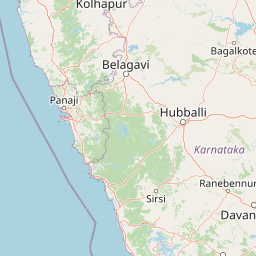
Map view of Nanda Lake

Use this park location map to pinpoint Nanda Lake in India, understand its exact geographic position, and read its mapped placement within the surrounding landscape more clearly.

Pigeon | © OpenStreetMap contributors

Location context for Nanda Lake

Goa
Park atlas

Compare nearby wetland reserves and regional conservation landscapes

Explore Parks Near Nanda Lake and Surrounding Western Ghats Protected Areas

Browse protected areas adjacent to Nanda Lake to examine regional freshwater habitats and coastal ecosystems. Comparing surrounding wildlife reserves reveals broader ecological patterns across the Western Ghats foothills.
National parkIndia
About 22 km away#1 closest

Northeast

Mollem National Park National Park: Geographic Context and Protected Landscape Exploration in India

Discover mapped terrain and biodiversity within the Western Ghats.

Delve into the specifics of Mollem National Park, a protected area renowned for its spectacular Dudhsagar Falls and the historic Tambdi Surla Mahadev Temple. This page provides detailed geographic context, showcasing the park's steep, forested slopes and its significance as part of the Western Ghats biodiversity hotspot. Understand the park's unique landscape, from its role as a critical watershed to its function as a habitat for diverse flora and fauna, offering rich material for atlas exploration and geographic appreciation of this Indian natural landmark.

IUCN
II
National parkIndia
About 38 km away#2 closest

Southeast

Anshi National Park in India: Mapped Protected Area and Regional Geography

Understanding India's protected landscapes and natural terrain.

Anshi National Park stands as a significant protected area within India, contributing to the nation's network of conservation landscapes. This park offers valuable data for understanding its mapped boundaries, terrain characteristics, and overall geographic position within the Indian subcontinent. Its designation as a national park underscores its importance for regional geography and structured landscape discovery.

Established
1987
Relief
Highland
Climate
Tropical
Access
Moderate access
Nature reserveKarnataka
About 150 km away#3 closest

East

Magadi Bird Sanctuary: A Key Wetland Nature Reserve in Karnataka, India

Mapped inland wetland and migratory bird sanctuary

Magadi Bird Sanctuary is a significant protected wetland nature reserve situated within the agricultural terrain of Karnataka. Known for the Magadi tank, this site provides a vital refuge for migratory waterbirds in the dry interior region, balancing active rural land use with essential biodiversity conservation across its catchment area.

Area
0.543 km²
Relief
Lowland
Access
Access unknown
Scope
Terrestrial
National parkIndia
About 219 km away#4 closest

North

Chandoli National Park: A National Park within India's Protected Lands Atlas

Mapped boundaries and regional landscape context for this protected area.

Chandoli National Park represents a distinct protected area within India, offering specific insights into national park landscapes and their geographic distribution. This entry focuses on its identity as a national park, detailing its mapped boundaries and regional context. It serves as a critical point for understanding the park's landscape within the atlas, providing factual geographic information for exploration and comparative study.

Area
317.67 km²
Established
2004
IUCN
II
Relief
Mountain
Watercolor painting showing a landscape with rolling hills, forests, and distant mountains
National parkKarnataka
221 km away#5 closest

Southeast

Kudremukh National Park: Karnataka's Protected Landscape and River Origin

Explore the geography of shola forests and grasslands.

Kudremukh National Park is a pivotal protected landscape in Karnataka, India, recognized for its distinctive montane grasslands and shola forests. This national park is a critical source for three major rivers: the Tunga, Bhadra, and Nethravathi, highlighting its ecological and geographic significance within the Western Ghats. The park's terrain features rolling hills and steep western slopes, contributing to its unique biodiversity and landscape character for atlas-based discovery.

Area
600.57 km²
Established
1987
IUCN
II
Relief
Mountain
National parkKarnataka
About 415 km away#6 closest

Southeast

Nagarahole National Park: National Park within Karnataka's Protected Geography

Explore mapped boundaries and regional landscape context.

Nagarahole National Park stands as a distinct national park entity within the state of Karnataka, India. This section focuses on its specific geographic footprint and the protected landscape it encompasses, offering valuable data for users engaged in atlas-based discovery of India's conservation areas and natural terrains. Understand its mapped geography and regional significance.

Area
847.98 km²
Established
1983
IUCN
II
Relief
Upland
National parkKarnataka
432 km away#7 closest

Southeast

Bandipur National Park: Karnataka's Protected Landscape and National Park Atlas Entry

Discover mapped terrain and diverse forest ecosystems in South India.

Bandipur National Park, a prominent national park within Karnataka, serves as a vital hub for understanding protected area geography and landscape diversity. Its ecological significance is amplified by its location at the intersection of the Deccan Plateau and the Western Ghats, supporting a unique blend of forest types and rich biodiversity. This entry provides essential context for atlas-based discovery, detailing the park's mapped terrain, its role as a tiger reserve, and its contribution to the Nilgiri Biosphere Reserve's conservation landscape.

Area
1,456.3 km²
Established
1973
IUCN
II
Relief
Mixed relief
National parkMaharashtra
450 km away#8 closest

North

Sanjay Gandhi National Park: Protected Forest Landscape and Ancient Buddhist Archaeology

Explore the mapped terrain and natural geography within Maharashtra.

Sanjay Gandhi National Park offers a unique blend of natural and historical discovery. This national park preserves vital tropical forest ecosystems characteristic of the Western Ghats region, providing a crucial urban wilderness habitat. Its most prominent feature is the Kanheri Caves, an extensive network of ancient rock-cut Buddhist structures showcasing over 2,400 years of continuous religious and cultural history. The park's protected boundaries encompass diverse terrain, supporting leopard populations and a rich variety of bird and insect life, all within the metropolitan limits of Mumbai, making it a significant site for geographic and conservation exploration.

Area
87 km²
Established
1996
IUCN
II
Visitors
2M annual

Common questions about visiting, size, designation, and location context for Nanda Lake

Nanda Lake FAQs for park facts, access, geography, and protected area context

Find quick answers about Nanda Lake, including protected-area facts, park geography, trail and visitor context, and how the park fits into its surrounding country and regional landscape.
MoriAtlas Explorer

Continue Your Protected Areas Search Across the Global Atlas

Deepen your exploration by continuing the structured search for national parks and protected areas worldwide. Utilize the comprehensive filtering capabilities to compare different conservation landscapes and refine your understanding of global park geography. Discover more about the distribution and characteristics of protected natural areas.

Global natural geography