

Mori Atlas logo
Wildlife reserveNargana Wilderness Area

Mapping the altitudinal gradient from Caribbean coastal rainforests to San Blas mountain cloud forests

Nargana Wilderness Area: A Detailed Geography and Protected Landscape Analysis

(Área Silvestre de Narganá)

The Nargana Wilderness Area serves as a critical protected landscape within Panama, spanning an expansive vertical range from the Caribbean shoreline to the crest of the Cordillera de San Blas. This wildlife reserve features an intact ecological transect that captures lowland Chocó-Darién rain forest, submontane forests, and cloud-drenched mountain ridges along the Continental Divide. Managed by the indigenous Guna people, the reserve functions as a vital forest link adjacent to Chagres National Park. Visitors and geographers alike analyze this terrain for its concentrated biodiversity, layered vegetation zones, and its role as a stable, community-governed wilderness corridor in the Guna Yala region.

tropical rainforestChocó-Darién forestsCaribbean coastcloud forestsubmontane forestindigenous governance

Nargana Wilderness Area

Wildlife reserve

Park overview

Structured park overview, official facts, and landscape profile for Narganá Wilderness Area

Narganá Wilderness Area park facts, protected area profile, and essential visitor context

Review the core facts for Narganá Wilderness Area, including designation, size, terrain, visitor scale, habitats, and operating context in one park-focused overview.

About Narganá Wilderness Area

The Narganá Wilderness Area sits on the Caribbean side of Panama within the Guna Yala indigenous region, where much of the land and sea is administered by the Guna people. Far from being a small enclave, it is one of the larger wilderness reserves in the country, spanning roughly 954 square kilometres and incorporating both coastal and mountain environments. This breadth allows the reserve to function as a single ecological corridor that links the shoreline of the Caribbean Sea with the high ridges of the Cordillera de San Blas.

The Cordillera de San Blas is a northern extension of Panama's eastern mountain system and forms part of the Continental Divide of the Americas, the great topographic line separating waters that flow toward the Pacific from those that drain into the Caribbean. Because the reserve reaches all the way to the spine of this range, it contains headwater forest that feeds rivers descending toward the Atlantic. At its western edge, the park borders Chagres National Park, an important watershed reserve that protects water for the Panama Canal, meaning the Narganá Wilderness Area participates in a chain of forested protected landscapes along the central Caribbean slope.

Eco-tourists, naturalists, and researchers visit Narganá in part because the proximity of the coast to the mountains produces a high concentration of habitats within a short horizontal distance. The reserve's altitudinal layering, going from coastal rainforest to cloud forest within roughly a thousand metres of vertical change, helps sustain both widespread lowland species and more range-restricted montane and cloud forest birds. The Guna people's strong tradition of territorial stewardship adds a cultural and governance dimension that distinguishes this area from many conventional national parks in the region.

Quick facts and research context for Narganá Wilderness Area

The Narganá Wilderness Area is located in the indigenous Guna Yala region along Panama's Caribbean coast and in the adjoining San Blas mountain range. Designated in 1994, it is administratively governed by the Guna people, with oversight from Panama's Ministerio de Ambiente.

The reserve covers approximately 954 square kilometres, extending from the Caribbean shoreline to the crest of the Cordillera de San Blas along the Continental Divide of the Americas. Its altitudinal range produces a layered forest system: lowland Chocó-Darién evergreen rain forest along the coast, submontane evergreen forest above 500 metres, and cloud forest on the uppermost ridges. The area is recognized for its birdwatching value and for species such as the black-crowned antpitta and red-throated caracara.

Protection and recognition

Documented terrestrial protection scope and international recognition records

Nargana Wilderness Area Protection Status and Official Designation History

Nargana Wilderness Area preserves a terrestrial protection scope established in 1994, reflecting structured conservation history without international recognition sources. Official designation records summarize the documented administrative framework and management parameters associated with the protected landscape.

Protection details

Protection scope
Terrestrial
Designated year
1994
Transboundary protection
No
Park context

Deeper park guide and search-rich context for Narganá Wilderness Area

Narganá Wilderness Area history, landscape, wildlife, and travel context

Explore Narganá Wilderness Area through its history, landscape character, ecosystems, wildlife, conservation priorities, cultural context, and seasonal travel timing in a structured park guide built for atlas discovery and search intent.

Why Narganá Wilderness Area stands out

The Narganá Wilderness Area is best known for its continuous transect of Caribbean-facing rainforest, running from sea-level coastal forest all the way up to cloud forest on the San Blas ridge. Because the reserve spans such a wide altitudinal gradient within a relatively compact area, it captures a layered sequence of tropical ecosystems that is uncommon along the Central American Caribbean slope. It is also recognized for its birdwatching appeal, especially the chance to see forest-specialist species such as the black-crowned antpitta and the red-throated caracara in contiguous tracts of mature rainforest. At the same time, the reserve is distinctive as one of Panama's larger indigenous-governed protected areas, with the Guna people serving as the governing body rather than functioning solely as a nationally administered national park.

Narganá Wilderness Area history and protected-area timeline

The Narganá Wilderness Area was formally designated as a protected area in 1994, during a period when Panama was expanding its system of conservation lands and when indigenous communities in Guna Yala were actively consolidating autonomous territorial control over their traditional lands.

The reserve has been governed since its designation by the indigenous peoples of the region, with the Guna people acting as the recognized governing body. Administrative oversight involves Panama's Ministerio de Ambiente, but the day-to-day stewardship decisions are rooted in the Guna community-based conservation and territorial framework that characterizes much of Guna Yala. Its position adjacent to Chagres National Park is also historically meaningful, as it places the Narganá Wilderness Area within the broader arc of protected forest landscape that has been assembled along Panama's Caribbean slope since the late twentieth century.

Narganá Wilderness Area landscape and geographic character

The landscape of the Narganá Wilderness Area is defined by its dramatic transition from sea to mountain. Along the Caribbean shoreline, the reserve includes coastal lowlands, beach environments, and the mouths of rivers that descend from the Cordillera de San Blas. This is one of the wettest and most biodiverse stretches of Panama, sheltered by the mountains that intercept trade winds carrying moisture off the Atlantic.

Moving inland and upward, the terrain climbs into the foothills and ridgelines of the Cordillera de San Blas, a relatively steep and rugged range that forms part of the Continental Divide of the Americas. The watershed here feeds rivers flowing both eastward into the Caribbean and westward toward Panama's interior basin. The ruggedness, combined with high rainfall and persistent cloud immersion on the upper slopes, helps sustain a layered forest system that changes character over relatively short horizontal distances.

Narganá Wilderness Area ecosystems, habitats, and plant life

The ecological identity of the Narganá Wilderness Area rests on its full altitudinal forest gradient along the Caribbean slope. In the coastal lowlands, the forest is classified as Chocó-Darién moist forest, a classic Neotropical evergreen rainforest ecosystem that is exceptionally species-rich and stretches from western Colombia through Panama. The canopy is dense, multi-layered, and typically tall, with a continuous closed cover that supports epiphytes, palms, and a high diversity of trees.

Above approximately 500 metres in elevation, the forest shifts into submontane evergreen forest, where trees become somewhat shorter and the understory structure changes in response to cooler temperatures and altered rainfall patterns. On the highest ridges, conditions become humid enough to sustain cloud forest, where persistent fog and moisture support a profusion of mosses, epiphytes, and orchids. This stacked forest mosaic provides habitat for both lowland and montane forest species within the boundaries of a single reserve, and it is fundamental to the area's biodiversity value.

Narganá Wilderness Area wildlife and species highlights

Wildlife in the Narganá Wilderness Area is shaped by the reserve's range of forest types and its relative remoteness along the San Blas range. The continuous tracts of undisturbed lowland and montane rainforest support healthy populations of forest-interior birds, mammals, and herpetofauna typical of the Chocó-Darién region.

The reserve has become particularly well known among birdwatchers, in part because its various forest strata host species that require intact and undisturbed forest. Notable records include the black-crowned antpitta, the speckled antshrike, and the red-throated caracara. The presence of birds spanning lowland and montane habitats within one area adds to the reserve's appeal for ornithological visitors, while larger mammals typical of Central American rainforest are supported by the contiguous canopy cover.

Narganá Wilderness Area conservation status and protection priorities

From a conservation perspective, the Narganá Wilderness Area matters because it preserves a substantial block of Chocó-Darién rainforest, one of the most threatened bioregions in the Neotropics, while also protecting critical watershed forest on the Caribbean slope. Its elevation gradient means that climate-sensitive habitats, such as cloud forest, are also contained within its boundaries, giving the reserve relevance for understanding how tropical forests may respond as climate patterns shift.

The reserve's governance by the indigenous Guna people adds a significant conservation dimension, because community-led management in Guna Yala has historically been associated with strong enforcement against hunting, logging, and land conversion. Its position adjacent to Chagres National Park enhances landscape connectivity, helping to maintain biological corridors along the Panama portion of the Continental Divide and supporting watershed integrity on a regional scale.

Narganá Wilderness Area cultural meaning and human context

The Narganá Wilderness Area is intimately connected to the cultural landscape of the Guna people, one of Panama's most prominent indigenous groups, who have long inhabited the islands, coast, and forested mountains of what is now known as the Guna Yala region. The reserve is formally governed by indigenous peoples, reflecting the Guna tradition of organizing land use through communal governance and customary law.

This blend of rainforest conservation with indigenous stewardship distinguishes the reserve from many state-administered national parks in Panama and Central America. Traditional Guna land-use systems, including controlled exploitation of forest resources and protection of culturally important sites, interact with the formal reserve designation, contributing to a layered cultural and ecological landscape that has been actively maintained by the Guna community over generations.

Top sights and standout views in Narganá Wilderness Area

The standout features of the Narganá Wilderness Area include its rare sea-to-summit transect of Caribbean rainforest, its status as one of Panama's larger protected areas along the Continental Divide, and its recognition as a destination for forest bird watching. The reserve's layered forest mosaic, ranging from Chocó-Darién lowland rainforest through submontane forest to cloud forest, gives it unusually concentrated ecological diversity for its size.

Equally notable is its indigenous-led model of conservation, with the Guna people serving as the governing body, and its landscape-level role as a neighbour to Chagres National Park. Together, these qualities make the reserve a meaningful example of community-based tropical forest protection in Central America.

Best time to visit Narganá Wilderness Area

Because the Narganá Wilderness Area spans both Caribbean coastal forest and montane cloud forest, weather and access conditions across the reserve vary, with the coastal zone generally experiencing a distinct wet and dry seasonal rhythm and the upper elevations remaining humid year-round. Birdwatching and general forest viewing are reasonably productive across much of the year, since the wetter conditions support active forest bird behaviour and fruiting cycles that sustain wildlife.

Visitors interested in clearer coastal conditions and easier movement along the shoreline tend to find drier windows more comfortable, while those prioritising sightings of cloud forest and montane species will find that mist and rain on the upper ridges are persistent features of the landscape at any time of year. As always, conditions in tropical Panamanian reserves can shift quickly, and flexibility around weather is often part of the experience.
Monthly climate preview

Measured monthly precipitation patterns and average temperature trends across the protected area

Nargana Wilderness Area Climate Normals and Long Term Temperature Records

Representative coordinate records show sustained mean monthly temperatures alongside distinct precipitation shifts throughout the year. Reviewing the comprehensive monthly climate profile reveals precise variations across every seasonal period.
Annual mean27 °C
26 °C27 °C
Jan26°
Feb26°
Mar26°
Apr27°
May27°
Jun27°
Jul27°
Aug27°
Sep27°
Oct27°
Nov27°
Dec27°
Warmest month
June

27.3 °C

Coolest month
February

26.1 °C

Wettest month
June

10.8 mm/day

Driest month
February

0.9 mm/day

Park location guide

Geography guide, regional context, and park location map for Narganá Wilderness Area

Narganá Wilderness Area park geography, regions, and map view in Panama

Understand where Narganá Wilderness Area sits in Panama through a broader geographic reading of the surrounding landscape, nearby location context, and its mapped position within the national park landscape.

How Narganá Wilderness Area fits into Panama

Panama is a presidential republic located at the southern end of Central America in North America. It gained independence from Spain in 1821 and from Colombia in 1903, the latter enabling the construction of the Panama Canal under U.S. supervision between 1904 and 1914. The canal was transferred to Panamanian control in 1999 following the Torrijos-Carter Treaties. With a population of approximately 4.3 million and an area of about 75,400 km², Panama has a high-income economy driven primarily by canal tolls, banking, commerce, and tourism.

Wider geography shaping Narganá Wilderness Area in Panama

Panama is located at the southern end of the Central American isthmus, stretching from the Caribbean coast in the north to the Pacific coast in the south. The country shares land borders with Costa Rica to the west and Colombia to the southeast. The terrain consists of coastal plains, mountain ranges including the Cordillera Central and Cordillera de Talamanca, and river valleys. The Panama Canal bisects the country, connecting the Atlantic and Pacific Oceans.

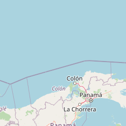
Map view of Narganá Wilderness Area

Use this park location map to pinpoint Narganá Wilderness Area in Panama, understand its exact geographic position, and read its mapped placement within the surrounding landscape more clearly.

Pigeon | © OpenStreetMap contributors

Location context for Narganá Wilderness Area

Guna Yala
Park atlas

Compare adjacent tropical forest reserves and regional conservation networks along the Caribbean slope

Other Parks Near Nargana Wilderness Area and Connected Protected Landscapes

Browse nearby national parks and protected areas sharing the rugged terrain of the Cordillera de San Blas and surrounding forested watersheds. Expanding the regional view reveals how Nargana Wilderness Area connects to a broader network of protected ecosystems across Panama.
National parkPanamá Province
About 78 km away#1 closest

West

Chagres National Park: National Park Protected Landscape Atlas

Discover geographic boundaries and natural terrain context.

Chagres National Park is a crucial protected area situated in Panamá Province, Panama. This page serves as an atlas-style gateway to understanding its specific geographic identity, mapped boundaries, and the surrounding natural terrain. It is designed for users seeking detailed insights into the park's protected landscape and its contribution to regional geography and conservation mapping efforts.

Area
1,290 km²
Established
1985
IUCN
II
Relief
Upland
National parkPanama
About 94 km away#2 closest

Southwest

Metropolitan Natural Park: Urban Protected Area and Forest Geography in Panama

Tracing the boundaries of a rare city-based wildlife refuge

Metropolitan Natural Park offers a significant study of urban conservation in Panama, protecting 265 hectares of Pacific tropical dry forest. Situated along the Panama Canal watershed, the terrain provides essential forest connectivity and diverse microhabitats, serving as a critical sanctuary within the dense metropolitan fabric of Panama City.

Area
2.65 km²
Established
1985
IUCN
II
Relief
Upland
A watercolor painting showing a stylized, panoramic view of soft green hills and distant pink-toned mountains against a white background.
Wildlife reservePanama City
About 94 km away#3 closest

Southwest

Metropolitan Natural Park: Protected Tropical Forest in Panama City

Mapping the Pacific watershed and urban wildlife corridors

Metropolitan Natural Park stands as a rare wildlife refuge, protecting a dense secondary tropical dry forest ecosystem inside the capital. The park boundary encompasses forested slopes and ridgelines that look out over the Panama Canal, providing a unique intersection of intact biodiversity and urban geography.

Area
2.65 km²
Established
1985
Relief
Lowland
Climate
Tropical
National parkColón Province
About 102 km away#4 closest

West

Soberanía National Park: Panama National Park Atlas, Geography, and Protected Landscape Details

Explore the mapped boundaries and regional geography of this national park.

Investigate Soberanía National Park, a designated national park situated in Panama's Colón Province. This entry offers detailed geographic context, focusing on its mapped protected area, landscape character, and role within regional conservation. Understand the spatial distribution and atlas significance of this protected land, essential for a structured geographic discovery of Panama's natural heritage.

Area
220 km²
Established
1980
IUCN
II
Relief
Lowland
National parkPanamá Oeste Province
About 148 km away#5 closest

Southwest

Altos de Campana National Park: National Park Protected Landscape and Geographic Context

Mapped boundaries and regional geography in Panamá Oeste Province.

Gain a structured understanding of Altos de Campana National Park, a designated national park located in Panamá Oeste Province. This page details its identity as a protected landscape, offering insights into its geographic placement and mapped boundaries for comprehensive atlas-style exploration. Understand its regional context and its contribution to Panama's network of protected areas.

Area
48.16 km²
Established
1966
IUCN
II
Relief
Mountain
National parkDarién Province
About 148 km away#6 closest

Southeast

Darién National Park: Darién Province National Park Geographic and Map Exploration

Discover its protected landscape and regional geographic context.

Darién National Park serves as a key protected area within Darién Province, offering an essential focus for geographic and atlas-based discovery. This dedicated park detail page provides insights into its mapped boundaries and its significance as a national park. Users can explore the park's specific geographic footprint and its place within the regional landscape, facilitating a structured understanding of protected natural areas. Dive into the mapped terrain and conservation landscape context that defines Darién National Park for comprehensive atlas exploration.

Area
5,790 km²
Established
1980
IUCN
II
Relief
Mountain
Wildlife reserveColombia
About 198 km away#7 closest

Southeast

Playona Acandí Fauna and Flora Sanctuary: Colombia's Wildlife Reserve Atlas and Protected Landscape

Explore protected area boundaries and natural terrain.

Delve into the geographic identity of Playona Acandí Fauna and Flora Sanctuary, a protected wildlife reserve in Colombia. This destination offers detailed mapping of its protected landscape, providing context for its natural terrain and its significance within the national atlas of conservation areas. Understand the specific geographic features that define this important wildlife sanctuary.

Area
262.32 km²
Relief
Lowland
Climate
Tropical
Scope
Mixed
National parkPanama
About 216 km away#8 closest

Southwest

Omar Torrijos "El Cope" National Park: Mapped Boundaries and Protected Landscape in Panama

Explore the geographic setting and natural terrain of this Panamanian national park.

Omar Torrijos "El Cope" National Park is a designated protected area offering rich opportunities for geographic discovery. Users can explore its mapped boundaries, understand its place within Panama's natural landscapes, and gain insight into the park's regional geographic context. This page provides a structured atlas-style view, highlighting the park's identity as a significant protected landform within Central America.

IUCN
II
Scope
Terrestrial

Common questions about visiting, size, designation, and location context for Narganá Wilderness Area

Narganá Wilderness Area FAQs for park facts, access, geography, and protected area context

Find quick answers about Narganá Wilderness Area, including protected-area facts, park geography, trail and visitor context, and how the park fits into its surrounding country and regional landscape.
MoriAtlas Explorer

Continue Your Protected Areas Search Across the Global Atlas

Deepen your exploration by continuing the structured search for national parks and protected areas worldwide. Utilize the comprehensive filtering capabilities to compare different conservation landscapes and refine your understanding of global park geography. Discover more about the distribution and characteristics of protected natural areas.

Global natural geography
