
Mori Atlas logo
Nature reserveNeuhofener Woog

Mapping the protected swamp forests, reed beds, and former river meanders of the Upper Rhine Plain.

Neuhofener Woog Nature Reserve: A Detailed Atlas of Rhine Floodplain Geography and Terrain

(Naturschutzgebiet Neuhofener Woog)

Neuhofener Woog occupies a significant position in the Rheinland-Pfalz landscape as a formally designated nature reserve. This 100-hectare protected area represents a former meander loop of the River Rhine, evolved into a complex mosaic of alder swamp forests, wet meadows, and near-natural water bodies. The terrain provides a critical refuge for floodplain ecosystems, showcasing the geomorphological remnants of historic river shifts within the Upper Rhine Plain.

wetlandfloodplainoxbow lakenature reserveRhineland-Palatinateswamp forest
A flat vector art style illustration of a pond in a forest with a waterfall cascading down a cliff face in the background.

Neuhofener Woog

Nature reserve

Park overview

Structured park overview, official facts, and landscape profile for Neuhofener Woog

Neuhofener Woog park facts, protected area profile, and essential visitor context

Review the core facts for Neuhofener Woog, including designation, size, terrain, visitor scale, habitats, and operating context in one park-focused overview.

About Neuhofener Woog

Neuhofener Woog is one of many nature reserves scattered across the Rhein-Pfalz-Kreis, the district that surrounds the city of Ludwigshafen in the Upper Rhine Plain. Covering roughly 100 hectares, it sits south of the village of Neuhofen an der Weinstraße, immediately east of the busy B 9 federal road and bordered to the south by the L 533. Despite its proximity to traffic corridors, the reserve functions as a quiet ecological enclave in an intensively used agricultural and urban landscape.

Geologically and ecologically, the reserve originates from a historic shift of the Rhine. As the great river straightened and shortened its course through natural processes and later through human regulation, an old meander was cut off and left to evolve independently. This former channel became the foundation for the wetlands that dominate Neuhofener Woog today. The terrain reflects classic floodplain morphology, with shallow basins, seasonally inundated flats, and gently elevated terraces that support different vegetation types.

The habitat mosaic is one of the area's defining qualities. Black alder swamp forest, ash and alder swamp woodland, wet and moist grassland, sedge beds, and reed stands all occur within the reserve's boundaries. Near-natural still waters, such as oxbow pools and ponds, are complemented by gently flowing channels that maintain the wetland hydrology. Scattered trees and hedgerows typical of floodplain environments add structural diversity to the site. Together, these features make Neuhofener Woog a representative and ecologically valuable remnant of Rhine floodplain nature.

Quick facts and research context for Neuhofener Woog

Neuhofener Woog is a protected wetland area of about 100 hectares in the Rhein-Pfalz-Kreis in Rhineland-Palatinate, Germany, situated south of Neuhofen. It was placed under formal nature protection by legal ordinance on 4 March 1999. The reserve occupies a former river loop of the Rhine and contains alder swamp forest, wet meadows, reed beds, and natural standing and flowing waters. It is part of the broader network of nature reserves in the Rhein-Pfalz-Kreis that safeguard remnant floodplain habitats.

Protection and recognition

Examine the documented conservation background and protected area data.

Neuhofener Woog Protection Status and International Recognition Record

Conservation metrics for Neuhofener Woog assemble official administrative records and international recognition tracking. Protected area data indexes framework details for geographic analysis and environmental research.

Protection details

WDPA ID
318850
Park context

Deeper park guide and search-rich context for Neuhofener Woog

Neuhofener Woog history, landscape, wildlife, and travel context

Explore Neuhofener Woog through its history, landscape character, ecosystems, wildlife, conservation priorities, cultural context, and seasonal travel timing in a structured park guide built for atlas discovery and search intent.

Why Neuhofener Woog stands out

Neuhofener Woog is best known for being a preserved former meander of the Rhine that has developed into a diverse wetland landscape. Its mix of black alder swamp forest, ash-alder swamp woodland, wet and moist meadows, sedge and reed communities, and near-natural water bodies makes it an ecologically rich floodplain refuge in an otherwise heavily modified Rhine lowland region.
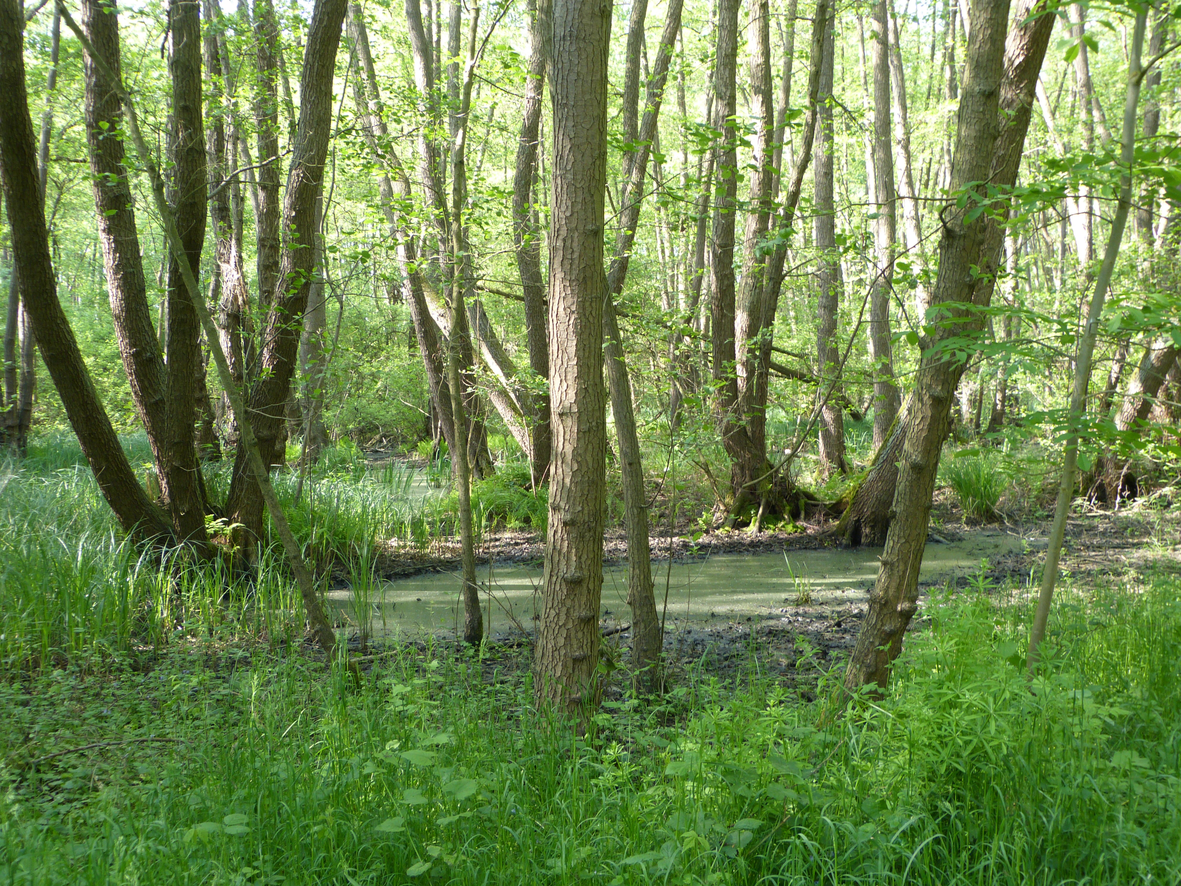
A view of a swamp forest with slender trees and standing water covered in duckweed.
A swamp forest section within the Neuhofener Woog nature reserve.

Neuhofener Woog history and protected-area timeline

Neuhofener Woog originated as part of the historic floodplain of the Upper Rhine. Over centuries, the active course of the Rhine shifted through natural processes and, increasingly, through river engineering works. An old meander was left as a detached loop, gradually losing its direct connection with the main river. As the abandoned channel aged, wetland vegetation colonized the shallow water and the surrounding silty soils, allowing a floodplain ecosystem to develop without further disturbance from large-scale river flows.

The area's status changed decisively in 1999. On 4 March of that year, the regional authorities issued a legal ordinance placing roughly 100 hectares around the former meander under formal nature protection (Naturschutzgebiet). This designation aimed to safeguard the wetland's hydrology, vegetation, and fauna against further drainage, conversion, or development. The reserve fits within a broader tradition of floodplain protection in Rhineland-Palatinate, where many similar oxbows and old river channels have been protected as compensation for centuries of Rhine straightening and floodplain loss.

Neuhofener Woog landscape and geographic character

The landscape of Neuhofener Woog is shaped by its origin as a former Rhine meander. The terrain consists of low-lying floodplain basins, wet depressions, and slightly higher terraces that mark the edges of the historic river loop. Shallow standing waters occupy the deepest parts of the former channel, while surrounding flats transition into damp meadows and reed beds. The relief is subtle, expressed through variations in soil moisture and vegetation rather than dramatic topography.

The wider setting is characteristic of the Upper Rhine Plain: an extensively leveled, agriculturally used landscape punctuated by residual floodplain features and woodland patches. Within this context, Neuhofener Woog stands out as a sharply defined natural area, marked by water-dominated ground, dense riparian woodland, and seasonal grassland. Roads border the reserve to the west and south, but the interior retains a distinctly wild and watery character compared with the surrounding farmland.

Neuhofener Woog ecosystems, habitats, and plant life

The nature of Neuhofener Woog centers on a closely interlinked system of woodland, wetland, and open water. Black alder forms the backbone of the swamp forest that occupies the wettest depressions, often growing alongside ash in productive but periodically waterlogged conditions. This alder-ash swamp woodland represents a classic floodplain forest community that has largely disappeared from much of the regulated Rhine plain.

Surrounding the forested core, wet and moist meadows provide open habitats that are kept moist by the high water table of the floodplain soils. Sedge beds and tall reed stands fringe pools, channels, and the edges of the meadows, creating transitional zones between open water, marsh, and dry ground. Near-natural still waters, such as abandoned channel pools, are accompanied by small flowing streams that recharge the wetland and maintain the hydrological conditions on which the surrounding communities depend. Individual characteristic trees and hedgerows further enrich the habitat mosaic.

Neuhofener Woog wildlife and species highlights

The wildlife value of Neuhofener Woog arises from its dense concentration of wetland and floodplain habitats within a heavily altered agricultural region. The combination of swamp forest, moist meadows, reed beds, and open water supports a rich community of invertebrates, amphibians, and wetland birds that depend on undisturbed, water-rich floodplain conditions. Amphibians in particular benefit from the network of shallow still waters and damp forest floor habitats.

Birdlife is one of the prominent features of the reserve. Reed beds and wet meadows provide nesting and foraging habitat for a range of species associated with floodplain wetlands, while the swamp forest interior offers cover and feeding areas for woodland species. Although the surrounding road network and farmland create a fragmented setting, the reserve's size and continuity of habitat make it an important local refuge for floodplain-dependent fauna within the Upper Rhine Plain.

Neuhofener Woog conservation status and protection priorities

Neuhofener Woog was designated as a protected area in 1999 to preserve a representative floodplain landscape that had been spared the worst effects of Rhine regulation and drainage. Its conservation value lies in the intact combination of near-natural forest communities, wet meadows, reed and sedge habitats, and natural waters within an otherwise intensively used region of Rhineland-Palatinate.

The reserve functions as a refugium for plant and animal communities that have declined across the broader Upper Rhine Plain due to channelization, groundwater lowering, and agricultural intensification. Maintaining the hydrology of the former meander is central to the reserve's management, as the swamp forest and marsh communities depend on consistently high water levels. In the wider context of nature conservation in the Rhein-Pfalz-Kreis, Neuhofener Woog is one of a chain of protected wet sites that together preserve elements of the Rhine floodplain that have been lost elsewhere.

Neuhofener Woog cultural meaning and human context

The name Woog is a regional term historically used along the Upper Rhine for backwaters, oxbows, and fish ponds cut off from the main river. The cultural context of Neuhofener Woog is tied to this long Rhine tradition of using and managing former river loops. Before modern river regulation, such oxbows were important local resources for fishing, water supply, and small-scale agriculture, and they remained visible landscape features even after they lost their direct connection to the Rhine.

Today, the reserve is embedded in a still strongly agricultural rural setting near Neuhofen, where villages and vineyards have long coexisted with the floodplain. The decision to protect the area in 1999 reflects a broader regional shift toward recognizing the ecological and cultural value of former river landscapes, treating them not just as relics of the Rhine's ancient course but as living landscapes worthy of preservation for future generations.

Top sights and standout views in Neuhofener Woog

Neuhofener Woog combines the relatively unusual combination of a preserved Rhine oxbow, classic floodplain forest types, and an intact hydrological system within an intensively used region of the Upper Rhine Plain. Its 100 hectares of swamp forest, wet meadows, reed beds, and natural waters provide a coherent example of how a former river loop can develop into ecologically valuable habitat when left undisturbed.

The reserve's accessibility, proximity to Neuhofen, and integration into a network of floodplain nature reserves across the Rhein-Pfalz-Kreis also give it regional importance beyond its local ecological role.

Best time to visit Neuhofener Woog

Neuhofener Woog is at its most atmospheric in spring and early summer, when rising temperatures and high water tables bring the wet meadows and reed beds into full growth. Late spring is typically a good period for observing wetland birds and amphibians, while early summer highlights the dense vegetation of the swamp forest and marshland.

Late summer and early autumn offer drier walking conditions, though water levels can drop and some of the meadows may appear more parched. Winter brings quiet, bare landscapes in the swamp forest and a different set of waterfowl and winter visitors along the still waters, making the reserve worth visiting even in colder months for those interested in floodplain landscapes in a more subdued seasonal mood.

Monthly climate preview

Long-term representative temperature and precipitation patterns for Neuhofener Woog

Neuhofener Woog Climate Normals and Measured Annual Weather by Month

Representative coordinate records show measured monthly temperature and precipitation fluctuations across the landscape. Reviewing these multi-year climate normals provides structured insight into the long-term annual rhythm.
Annual mean10 °C
0 °C20 °C
Jan
Feb
Mar
Apr
May14°
Jun18°
Jul20°
Aug20°
Sep15°
Oct10°
Nov
Dec
Warmest month
July

20.4 °C

Coolest month
January

0.3 °C

Wettest month
July

2.2 mm/day

Driest month
April

1.4 mm/day

Park location guide

Geography guide, regional context, and park location map for Neuhofener Woog

Neuhofener Woog park geography, regions, and map view in Germany

Understand where Neuhofener Woog sits in Germany through a broader geographic reading of the surrounding landscape, nearby location context, and its mapped position within the national park landscape.

How Neuhofener Woog fits into Germany

Germany is a federal republic in Western and Central Europe with a population of over 83 million across sixteen constituent states. It is Europe's largest economy by nominal GDP and a major global exporter and importer. The capital is Berlin, and the country borders Denmark, Poland, Czech Republic, Austria, Switzerland, France, Luxembourg, Belgium, and the Netherlands.

Wider geography shaping Neuhofener Woog in Germany

Germany is located in Western and Central Europe, spanning 357,022 km². It borders Denmark to the north, Poland and the Czech Republic to the east, Austria and Switzerland to the south, and France, Luxembourg, Belgium, and the Netherlands to the west. The country has coastlines on the Baltic Sea and North Sea to the north, with the Alps located in the southern region.

Map view of Neuhofener Woog

Use this park location map to pinpoint Neuhofener Woog in Germany, understand its exact geographic position, and read its mapped placement within the surrounding landscape more clearly.

Pigeon | © OpenStreetMap contributors

Location context for Neuhofener Woog

Rheinland-Pfalz

Visual exploration of wetland habitats, floodplain terrain, and oxbow waters

Neuhofener Woog Photos and Landscape Scenery in Rhineland-Palatinate

Photographic records document the diverse wetland habitats, swamp forests, and open water channels defining the protected landscape of Neuhofener Woog. Visual analysis of terrain variations and riparian vegetation reveals the ecological character of this preserved Rhine meander within the Upper Rhine Plain.

A view of a swamp forest with slender trees and standing water covered in duckweed.

Park atlas

Compare nearby wetland reserves and regional floodplain landscapes in Rhineland-Palatinate

Explore Parks Near Neuhofener Woog And Surrounding Protected Areas

Continue geographic discovery by browsing protected areas and wetland reserves located near Neuhofener Woog. Compare regional floodplain terrain, oxbow habitats, and riparian ecosystems across the Upper Rhine Plain.
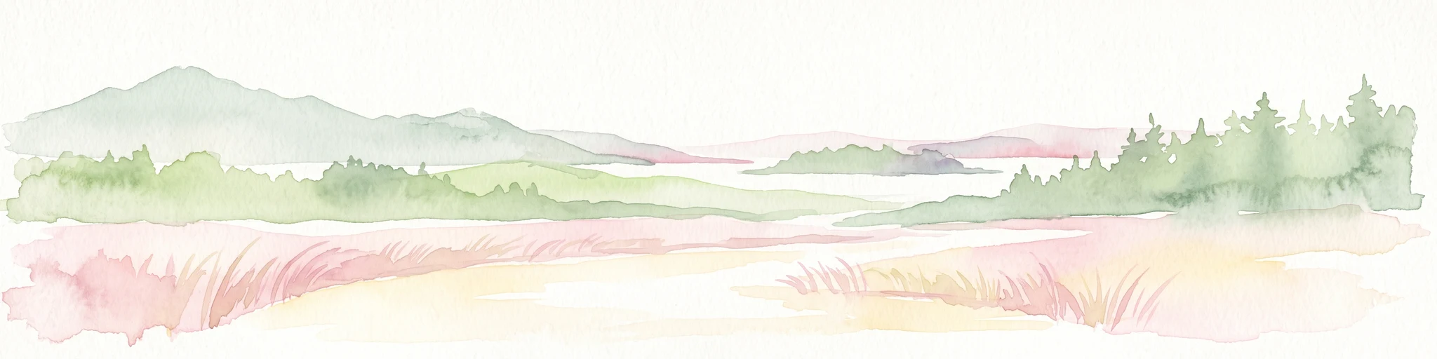
A pale, soft watercolor painting showing a flat, grassy landscape with distant rolling hills and patches of trees.
Nature reserveRhineland-Palatinate
About 3.9 km away#1 closest

North

Pfälzische Rheinauen Nature Reserve: Protected Alluvial Landscapes in Rhineland-Palatinate

Regional floodplain geography and protected area map context

The Pfälzische Rheinauen is a major landscape protection area encompassing a mosaic of habitats along the Upper Rhine. From the Haardt mountains eastward, this region features rare alluvial forests, reclaimed gravel pit lakes, and complex river systems. It remains a focal point for understanding the integration of floodplain biodiversity with long-standing human activity in Western Germany.

Area
208.33 km²
Established
1971
Relief
Lowland
Climate
Temperate
A horizontal watercolor painting showing a stylized, soft-focus forest landscape with green trees against a pale, warm-toned ground.
Protected areaRhineland-Palatinate
About 5.1 km away#2 closest

Southwest

Speyerer Wald: Protected Alluvial Forest and Inland Sand Dune Landscape

Regional geography and protected area context in Rhineland-Palatinate.

Speyerer Wald offers a look into the formation of Rhine Plain alluvial fans and the survival of forest ecosystems on poor, sandy soils. This protected expanse showcases the intersection of inland dunes, dry sand grasslands, and riparian stream corridors. It serves as a key case study in regional landscape evolution, highlighting how ice age deposits continue to dictate current habitat distribution and nature conservation priorities.

Established
1981
Relief
Lowland
Climate
Temperate
Access
Easy access
A soft watercolor painting depicting a winding river landscape with lush green vegetation, grassy banks, and a treeline in the distance, set against a plain white background.
Nature reserveRheinland-Pfalz
About 5.8 km away#3 closest

East

Horreninsel Nature Reserve: Detailed Rhine Floodplain Geography and Protected Land Map

A preserved riparian zone in Rheinland-Pfalz, Germany.

Horreninsel represents a significant protected floodplain along the Upper Rhine, featuring a narrow, elongated strip of habitat between the river and its western dike. This reserve hosts diverse terrain, from old river channels and lush Auwald forests to unique Stromtalhalbtrockenrasen dry grasslands, offering a deep look into regional fluvial ecosystems.

Area
0.55 km²
Established
1978
Relief
Lowland
Climate
Temperate
Protected landscapeBaden-Württemberg
About 5.9 km away#4 closest

Northeast

Waldpark Mannheim: Protected Floodplain Landscape and Riparian Geography

Natural fluvial terrain along the Rhine in Baden-Württemberg

Waldpark Mannheim encompasses 150 hectares of protected floodplain forest, meadows, and old Rhine river channels. This landscape serves as a crucial ecological zone, defined by shifting water levels and a lack of artificial flood defenses, illustrating the natural rhythm of riparian habitats in southwestern Germany.

Area
1.496 km²
Established
1975
IUCN
V
Relief
Lowland
A minimalist watercolor illustration of a wetland scene with soft green hills in the distance, a central water body, and faint pink and green vegetation in the foreground against a white background.
Protected areaRhineland-Palatinate
About 7.3 km away#5 closest

Northwest

Maudacher Bruch: Protected Wetland and Historical Meander in Rhineland-Palatinate

Mapping the urban marshes and meadows of Ludwigshafen

Maudacher Bruch is a significant protected area in Rhineland-Palatinate, defined by its origin as an ancient silted-up meander of the River Rhine. This horseshoe-shaped landscape sustains diverse wetland habitats and serves as a natural counterpoint to the surrounding industrial city. Explore its complex geography, from the central marshland meadows and ponds to the elevated views across the Upper Rhine Plain.

Area
5.23 km²
Relief
Lowland
Climate
Temperate
Access
Easy access
Watercolor painting showing a calm river shoreline with soft green trees and light pinkish ground accents.
Protected areaRhineland-Palatinate
About 7.8 km away#6 closest

Southeast

Angelhofer Altrhein: Protected Riparian Environment in Rhineland-Palatinate

Historic river oxbow, floodplain forests, and Natura 2000 habitats

Located in the heart of the Upper Rhine plain, the Angelhofer Altrhein constitutes an essential protected area known for its distinct floodplain meadow and forest ecosystems. This backwater environment, once a main channel of the Rhine, provides critical habitat for diverse species and serves as a natural contrast to the surrounding industrial and recreational landscapes of the region.

Relief
Lowland
Climate
Temperate
Access
Easy access
Scope
Terrestrial
A soft, light watercolor painting of a rolling rural landscape featuring rows of vineyards in the foreground and tree-covered hills in the distance.
Nature reserveRheinland-Pfalz
About 12 km away#7 closest

West

Haardtrand Nature Reserve: Geographic Overview and Protected Landscape Mapping

Bird protection area within the Rheinland-Pfalz region.

Spanning roughly 14,700 hectares, Haardtrand serves as a critical link between the Palatinate Forest and the Rhine valley. This nature reserve is composed of a distinctive mosaic of habitat types, including mature broadleaf woodlands, traditional orchard meadows, and sandy terraces, which together create a highly structured environment for diverse raptors and forest-dwelling bird species.

Area
147.28 km²
Established
2004
A watercolor painting showing a winding river flowing through a green valley with rolling hills in the background, executed in a soft, impressionistic style with light greens, purples, and pinks.
Protected landscapeRhein-Neckar-Kreis
About 14 km away#8 closest

Northeast

Neckartal I-Kleiner Odenwald: Protected Landscape and Regional Geography in Rhein-Neckar-Kreis

Mapping the sandstone ridges and river valley systems of southwestern Germany.

The Neckartal I-Kleiner Odenwald protected landscape serves as a prime example of a transitional natural region where the Neckar river cuts through the Odenwald highlands. This record provides a detailed look at the area's physical geography, including its signature abandoned river bends, block-strewn slopes, and the dense forest canopy that characterizes this significant protected land in the Rhein-Neckar-Kreis district.

Area
63.159 km²
Established
2002
IUCN
V
Relief
Mountain

Common questions about visiting, size, designation, and location context for Neuhofener Woog

Neuhofener Woog FAQs for park facts, access, geography, and protected area context

Find quick answers about Neuhofener Woog, including protected-area facts, park geography, trail and visitor context, and how the park fits into its surrounding country and regional landscape.
MoriAtlas Explorer

Continue Your Protected Areas Search Across the Global Atlas

Deepen your exploration by continuing the structured search for national parks and protected areas worldwide. Utilize the comprehensive filtering capabilities to compare different conservation landscapes and refine your understanding of global park geography. Discover more about the distribution and characteristics of protected natural areas.

Global natural geography