Mori Atlas logo
Wildlife reserveNewhaven Wildlife Sanctuary

Mapping the desert dunes, salt lakes, and conservation terrain of central Australia

Newhaven Wildlife Sanctuary: A Comprehensive Atlas of Arid Desert Protected Landscapes

Newhaven Wildlife Sanctuary represents an expansive protected reserve spanning over 2,600 square kilometres within the Northern Territory. This atlas entry details the geographic mosaic of the sanctuary, featuring complex parallel dune systems, arid salt lakes, and rocky outcrops that define this central Australian landscape. By tracing these boundaries and landforms, observers gain insight into the scale of predator-free conservation and the unique environmental features found where the Tanami and Great Sandy deserts meet.

desert sanctuaryarid zoneGreat Sandy DesertTanami Desertthreatened species recoverypredator-free enclosure

Newhaven Wildlife Sanctuary

Wildlife reserve

Park overview

Structured park overview, official facts, and landscape profile for Newhaven Wildlife Sanctuary

Newhaven Wildlife Sanctuary park facts, protected area profile, and essential visitor context

Review the core facts for Newhaven Wildlife Sanctuary, including designation, size, terrain, visitor scale, habitats, and operating context in one park-focused overview.

About Newhaven Wildlife Sanctuary

Newhaven Wildlife Sanctuary occupies a vast expanse of the arid interior of the Northern Territory, lying several hundred kilometres north-west of Alice Springs in the Great Sandy Desert bioregion. Stretching across more than 2,600 square kilometres, the reserve encompasses a classic central Australian desert landscape: parallel sand dunes, broad claypans, salt lakes, and low rocky hills, all set against open plains that give the property its remarkable sense of openness and scale.

Although the land had long been associated with Aboriginal peoples, particularly the Warlpiri, Luritja, and Anmatyerre, the property's modern history began when Alex Coppock assumed the pastoral lease known as Newhaven Station in the mid-twentieth century. The Coppocks ran the property as a low-intensity cattle station, a light form of pastoral management that, combined with permanent water sources for their horses, inadvertently preserved habitat for rare desert species. When the station was acquired by conservation interests in 2000, much of that ecological value was secured for the long term, and the property was progressively de-stocked and managed as a wildlife sanctuary.

Today Newhaven is recognised as one of the most ecologically significant private conservation reserves in arid Australia. Its protected environment covers grasslands, shrublands, and woodlands that support over 600 plant species and an unusually rich complement of desert fauna. The sanctuary is particularly valued for populations of threatened birds and mammals that have experienced serious declines elsewhere on the continent. Its combination of Aboriginal land connections, modern conservation science, and large-scale infrastructure, including a continent-leading predator-proof fence, places Newhaven at the intersection of ecological restoration, cultural stewardship, and landscape conservation in the Australian outback.

Quick facts and research context for Newhaven Wildlife Sanctuary

Newhaven Wildlife Sanctuary is a 2,615 square kilometre nature reserve in the Lake Mackay region of the Northern Territory, situated in the Great Sandy Desert bioregion. It is approximately 80 kilometres from the Aboriginal community of Yuendumu and is jointly owned and managed by the Australian Wildlife Conservancy and Birds Australia.

The sanctuary protects ten distinct vegetation communities and over 600 plant species across dunes, salt lakes, claypans, and rocky hills. It is a stronghold for threatened desert fauna including the night parrot, greater bilby, brush-tailed mulgara, great desert skink, and black-flanked rock-wallaby. A predator-proof fence completed in 2018 encloses a 9,390 hectare area to support rewilding initiatives.

Protection and recognition

Documented terrestrial protection framework and formal designation records

Newhaven Wildlife Sanctuary Protection Status and Management Scope

Newhaven Wildlife Sanctuary maintains a documented terrestrial protection status within the regional conservation framework. Official records outline the established management scope and international recognition data for this protected area.

Protection details

Protection scope
Terrestrial
Transboundary protection
No
Park context

Deeper park guide and search-rich context for Newhaven Wildlife Sanctuary

Newhaven Wildlife Sanctuary history, landscape, wildlife, and travel context

Explore Newhaven Wildlife Sanctuary through its history, landscape character, ecosystems, wildlife, conservation priorities, cultural context, and seasonal travel timing in a structured park guide built for atlas discovery and search intent.

Why Newhaven Wildlife Sanctuary stands out

Newhaven is best known for being one of the most important refuges in arid central Australia for rare and threatened desert wildlife, particularly birds such as the night parrot, princess parrot, grey falcon, and grey honeyeater. Its sheer size, more than 2,600 square kilometres of largely intact desert habitat, makes it a critical stronghold for mammals like the greater bilby that have been lost across much of their former range. The sanctuary is also distinguished by the construction of what has been described as the world's longest cat-proof fence, which shelters a substantial predator-free area dedicated to re-establishing vulnerable native species. Translocation programs involving golden bandicoots and, more recently, brushtail possums have put Newhaven at the forefront of large-scale desert rewilding in Australia.
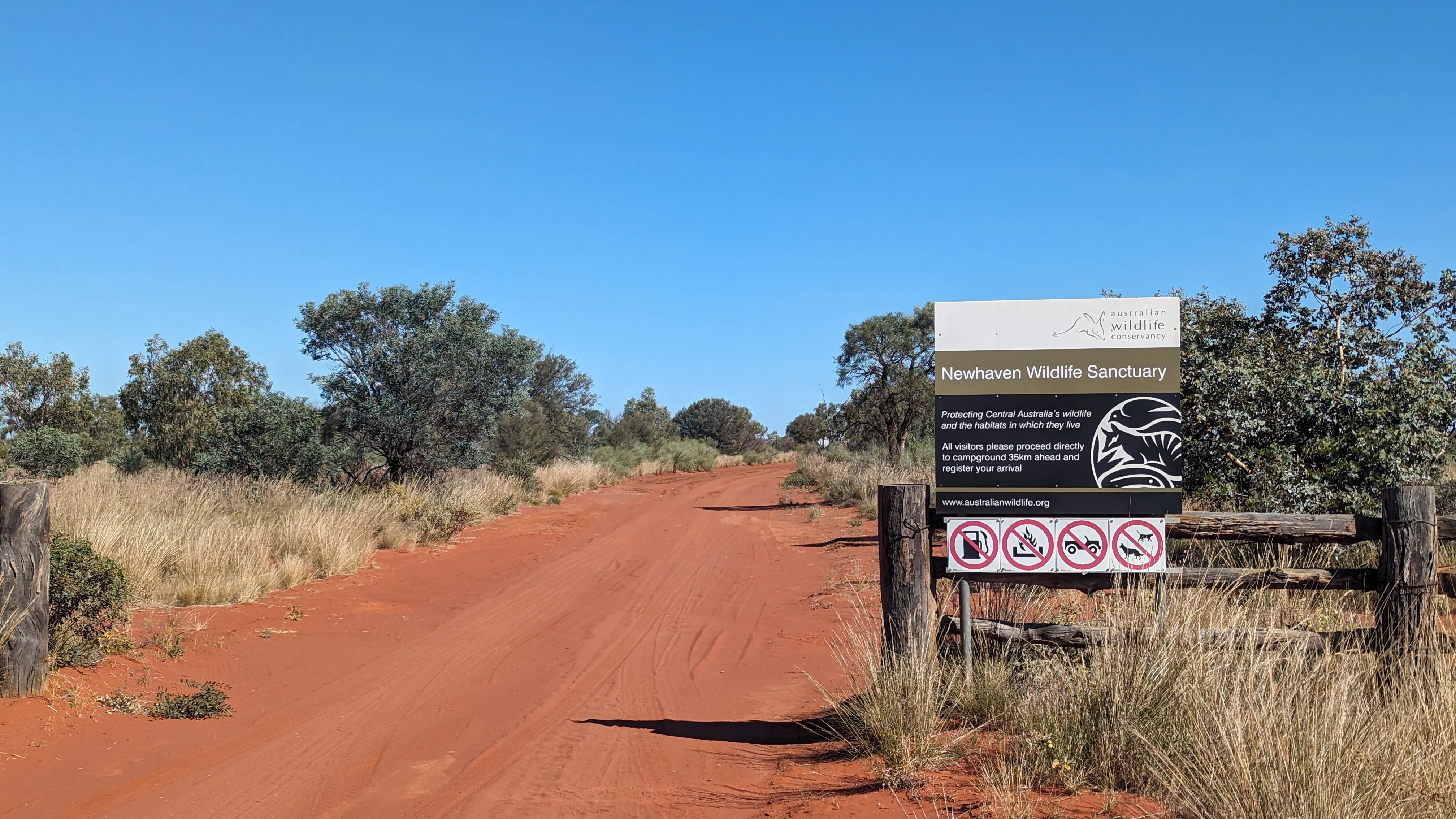
A sign for Newhaven Wildlife Sanctuary mounted on a wooden fence next to a red dirt road surrounded by arid shrubs.
The entrance sign for Newhaven Wildlife Sanctuary in the Northern Territory.

Newhaven Wildlife Sanctuary history and protected-area timeline

The land that now forms Newhaven Wildlife Sanctuary is traditionally associated with the Warlpiri, Luritja, and Anmatyerre peoples, and Aboriginal sacred sites, including Yunkanjini at Lake Bennett, have been identified within the property. Native title over the surrounding country was formally recognised in 2010 when it was granted to the Ngalia-Warlpiri and Luritja peoples, reinforcing the deep and continuing cultural relationship between Indigenous communities and this desert landscape.

The station itself was established as a pastoral lease in the Tanami Desert during the twentieth century. In 1959, Alex Coppock took over the lease, and with his wife gave it the name Newhaven. Rather than running heavy commercial stocking, the Coppocks maintained only a subsistence herd, a practice later credited with helping protect a surprising variety of rare desert flora and fauna on the property. Waler horses brought from the Stuart Highway region added to the property's pastoral character, and the water infrastructure for these animals attracted and supported native wildlife as well.

In December 2000, Birds Australia acquired Newhaven Station, with support from the Australian Government's National Reserve System, and began the process of converting the property into a dedicated conservation reserve. By 2006 the Australian Wildlife Conservancy had joined as a managing partner, and from 2007 the area was included in the locality of Lake Mackay. A landmark moment came in April 2018, when construction was completed on a very long cat-proof fence enclosing a 9,390 hectare predator-free area, opening a new chapter in the sanctuary's role as a site for threatened species recovery. Since then, Newhaven has hosted significant translocation efforts, including the reintroduction of golden bandicoots in 2023 and brushtail possums in 2024 through partnerships that blend Western science with Indigenous ranger knowledge.

Newhaven Wildlife Sanctuary landscape and geographic character

Newhaven sits deep within the Great Sandy Desert bioregion, where ancient landforms meet the wide-open character typical of the central Australian outback. The most prominent physical features are long parallel sand dunes that sweep across the property, giving the terrain a rippled, almost rhythmic quality from above. Between these dunes lie broad claypans and salt lakes, including culturally significant features such as Lake Bennett, which fill and recede with rare rainfall events and create occasional mosaics of wetland habitat in an otherwise arid setting.

Rocky hills and outcrops punctuate the plains, providing elevated ground and sheltered micro-habitats that contrast with the surrounding sandy country. The combination of dunes, claypans, salt lakes, flats, and hill country gives Newhaven a complex and varied topography that is unusually rich for a desert reserve of its kind.

Vegetation responds directly to this underlying landform pattern. Sand dunes support shrubland and open woodland, while heavier soils around the claypans and drainage lines carry denser grasslands, and rocky areas host their own specialised plant communities. Together these elements produce a mosaic of desert vegetation that shifts subtly across the property and reinforces the sense of travelling through an enormous, continuous landscape of contrasting textures and colours.

Newhaven Wildlife Sanctuary ecosystems, habitats, and plant life

Ecologically, Newhaven represents one of the best-preserved examples of central Australian desert habitat, encompassing a complete spectrum of arid-zone vegetation communities. The sanctuary contains ten distinct vegetation types, ranging from spinifex-dominated grasslands and open shrublands through to eucalypt woodlands on favourable soils. More than 600 plant species have been recorded on the property, making it a significant botanical archive as well as a wildlife reserve.

The mosaic of dunes, claypans, salt lakes, and rocky hills creates a wide variety of microhabitats within a relatively continuous landscape, and this variety is reflected in the diversity of life the sanctuary supports. Seasonal rains, when they come, transform the claypans and depressions into temporary wetlands that briefly support waterbirds and inundate-dependent species, while the surrounding dunes and shrublands maintain populations of arid-adapted animals even during extended dry periods.

Because the property was never heavily developed, the ecological processes that shape this landscape, including fire, flooding, and predator-prey dynamics, are able to operate across a very large area. This gives Newhaven particular value as a reference site for understanding how central Australian ecosystems function at landscape scale, and as a reservoir of genetic diversity that has been lost in more fragmented parts of the region.

Newhaven Wildlife Sanctuary wildlife and species highlights

Newhaven's wildlife profile is dominated by species that have become rare or threatened elsewhere in arid Australia, which is one reason the sanctuary is considered so important. It supports iconic desert mammals such as the greater bilby, brush-tailed mulgara, black-flanked rock-wallaby, and the elusive marsupial mole, all of which have undergone serious declines across much of their former range.

The sanctuary is perhaps most celebrated for its birdlife. Threatened and range-restricted species recorded on the property include the night parrot, one of the rarest birds in Australia; the grey falcon, a wide-ranging arid-zone predator; the princess parrot, known for its dependence on mature desert woodlands; the striated grasswren; and the grey honeyeater, a species with a highly restricted global range. The great desert skink and other reptiles add to the reptile diversity that characterises central Australian sand-ridge country.

Active species recovery work has become a defining feature of Newhaven. The 9,390 hectare predator-free enclosure has enabled reintroduction trials for mammals that have disappeared from the surrounding region. In 2023, golden bandicoots were translocated to the property from Western Australia, followed in 2024 by brushtail possums reintroduced from Kangaroo Island with the support of Indigenous ranger teams, marking some of the most significant recent rewilding efforts in Australia's interior.

Newhaven Wildlife Sanctuary conservation status and protection priorities

Newhaven represents a major achievement in private conservation in Australia. By purchasing what had been a pastoral station in 2000, conservation organisations secured a vast tract of intact desert habitat that would otherwise have remained vulnerable to grazing pressure, invasive predators, and habitat degradation. The sanctuary's IUCN Category II designation, the same classification used for national parks, reflects its status as a high-level protected area.

The most prominent conservation initiative at Newhaven is the construction of a very long cat-proof fence, completed in 2018, which encloses a 9,390 hectare area kept free of invasive predators. By removing feral cats, foxes, and other introduced threats from a defined area, the fence creates conditions under which vulnerable native species can again establish self-sustaining populations. This predator-free zone supports the sanctuary's role as a refuge and source population for animals that have been lost from the surrounding region.

Beyond infrastructure, Newhaven functions as a conservation hub for collaborative science and Indigenous land management. Programs bringing together AWC ecologists, Birds Australia researchers, and Indigenous ranger teams have enabled surveys, translocations, and monitoring work that would be difficult to undertake elsewhere. The recognition of native title in 2010, the partnership approach to species recovery, and major translocations of golden bandicoots and brushtail possums all underline the sanctuary's role as a working model for ecological restoration in Australia's arid centre.

Newhaven Wildlife Sanctuary cultural meaning and human context

Newhaven sits within a landscape that carries deep Aboriginal heritage, with traditional associations linking the Warlpiri, Luritja, and Anmatyerre peoples to the area across generations. Sacred sites on the property, including Yunkanjini at Lake Bennett, reflect the long and ongoing connection between Indigenous communities and this desert country. The granting of native title to the Ngalia-Warlpiri and Luritja peoples in 2010 formalised this relationship in modern legal terms.

Cultural engagement at the sanctuary is increasingly central to its conservation work. Indigenous ranger teams have taken part in species translocations, including the 2024 reintroduction of brushtail possums, which were welcomed at the Anmatyerr community of Laramba with a traditional Possum Dreaming ceremony. These practices, which integrate ecological restoration with cultural protocols, illustrate how Newhaven functions as a meeting place between Western conservation science and Aboriginal stewardship traditions.

The property's pastoral history also forms part of its wider cultural context. Decades of light grazing under the Coppock family helped preserve ecological values that later became the foundation of the sanctuary, and the personal involvement of the original station owners in guiding early scientific work reflects the often personal connections between outback pastoralists and the land they managed.

Top sights and standout views in Newhaven Wildlife Sanctuary

Newhaven Wildlife Sanctuary stands out for the sheer scale of its protected desert landscape, its importance for threatened arid-zone wildlife, and its pioneering role in predator-free conservation in central Australia. The sanctuary's night parrot, greater bilby, and princess parrot records underline its status as a refuge for species that have vanished elsewhere on the continent.

Equally distinctive is Newhaven's combination of high-technology infrastructure, in the form of the long cat-proof fence, with deeply rooted Aboriginal cultural engagement. Reintroduction projects for golden bandicoots and brushtail possums, supported by Indigenous ranger teams, have turned the sanctuary into one of the most visible laboratories for landscape-scale rewilding in the Australian outback.

Best time to visit Newhaven Wildlife Sanctuary

Newhaven lies deep in arid central Australia, where climate strongly influences what visitors experience on the ground. The cooler months, roughly from late autumn through early spring, typically bring more comfortable temperatures for outdoor activity and are widely considered the most practical time to explore the region. During this period the air is usually clear, daytime warmth is moderated, and the desert landscape is at its most accessible.

Summer in the region can bring intense heat and unpredictable storms, conditions that make travel in the remote interior more demanding. While the warmer season sometimes delivers spectacular wildflower responses and dramatic skies after rainfall, it also produces extremes that limit visitor comfort and access. Wildlife observation can be rewarding at any time of year, but cooler months tend to favour active movement of fauna during daylight hours, particularly birds and mammals associated with the sanctuary's open country.
Monthly climate preview

Long-term representative measurements of temperature and precipitation rhythms

Newhaven Wildlife Sanctuary Climate Normals and Annual Temperature Patterns

Representative coordinates record distinct annual temperature swings and monthly precipitation patterns across Newhaven Wildlife Sanctuary. Detailed twelve-month climate normals provide a complete comparative baseline for analyzing regional weather rhythms.
Annual mean24 °C
14 °C31 °C
Jan31°
Feb30°
Mar28°
Apr24°
May18°
Jun14°
Jul14°
Aug17°
Sep22°
Oct26°
Nov29°
Dec31°
Warmest month
January

31.4 °C

Coolest month
July

14.3 °C

Wettest month
February

1.8 mm/day

Driest month
August

0.1 mm/day

Park location guide

Geography guide, regional context, and park location map for Newhaven Wildlife Sanctuary

Newhaven Wildlife Sanctuary park geography, regions, and map view in Australia

Understand where Newhaven Wildlife Sanctuary sits in Australia through a broader geographic reading of the surrounding landscape, nearby location context, and its mapped position within the national park landscape.

How Newhaven Wildlife Sanctuary fits into Australia

Australia is a constitutional monarchy and federal parliamentary democracy comprising six states and ten territories. With a population of nearly 28 million, it is one of the world's most urbanised countries, with most people concentrated on the eastern seaboard. The country has a high Human Development Index and is known for its cultural diversity, ancient Aboriginal heritage, and unique wildlife.

Wider geography shaping Newhaven Wildlife Sanctuary in Australia

Australia occupies the entire Australian continent, the island of Tasmania, and numerous smaller islands. It is the world's flattest and driest inhabited continent, featuring vast deserts in the interior (the Outback), tropical rainforests along the eastern coast, and a coastline bordering the Indian and Pacific Oceans.

Map view of Newhaven Wildlife Sanctuary

Use this park location map to pinpoint Newhaven Wildlife Sanctuary in Australia, understand its exact geographic position, and read its mapped placement within the surrounding landscape more clearly.

Pigeon | © OpenStreetMap contributors

Location context for Newhaven Wildlife Sanctuary

Northern Territory

Visual exploration of desert dunes, arid terrain, and protected habitats

Newhaven Wildlife Sanctuary Photos and Landscape Scenery

Visual records capture the sweeping sand dunes, salt lakes, and diverse arid habitats defining Newhaven Wildlife Sanctuary. Examining these protected landscapes reveals the rugged terrain and natural sanctuary environment supporting central Australian wildlife.

A sign for Newhaven Wildlife Sanctuary mounted on a wooden fence next to a red dirt road surrounded by arid shrubs.

Park atlas

Compare regional conservation landscapes and surrounding desert terrain

Explore Protected Areas and Parks Near Newhaven Wildlife Sanctuary

Browse other protected areas and national parks situated within the wider central Australian desert bioregion. Continuing the geographic comparison reveals broader patterns in arid terrain and regional conservation reserves.
National parkNorthern Territory
About 143 km away#1 closest

Southeast

Tjoritja / West MacDonnell National Park: National Park Atlas and Protected Landscape

Explore the dramatic MacDonnell Ranges terrain and geography.

Delve into the protected geography of Tjoritja / West MacDonnell National Park, a significant national park in Australia's Northern Territory. This landscape features striking mountain formations, deep gorges like Standley Chasm and Glen Helen, and is intrinsically linked to the famous Larapinta Trail and the Arrernte people's cultural heritage. Understanding its mapped boundaries and regional context provides essential insight into this iconic Central Australian protected area.

Area
2,568.61 km²
Established
1992
IUCN
II
Relief
Mountain
National parkNorthern Territory
About 147 km away#2 closest

South

Watarrka National Park: Central Australian National Park with Iconic Canyon Landscapes

Explore its mapped terrain and protected area geography.

Watarrka National Park, located in the Northern Territory, is distinguished by the dramatic sandstone formations of Kings Canyon. This protected area showcases a unique arid zone biodiversity, including rare plant species and ancient cycad forests. Its geological significance and Aboriginal heritage make it a compelling point of study for understanding Central Australia's natural and cultural landscapes through structured atlas exploration.

Area
1,051.85 km²
Established
1989
IUCN
II
Visitors
176.1K annual
A watercolor illustration of a wide, rolling landscape with distant hills, sparse trees, and soft, warm tones.
Protected areaNorthern Territory
About 148 km away#3 closest

North

Northern Tanami Indigenous Protected Area: A Vast Desert Wilderness and Protected Landscape

Central Australia, Northern Territory mapping and ecological overview

Located in the heart of the Tanami Desert, this 40,050 square kilometer protected area stands as one of the largest Aboriginal-managed conservation sites in Australia. The region is defined by continuous hummock grasslands, wide horizons, and arid drainage systems. It provides critical habitat for threatened desert species while demonstrating the integration of traditional ecological knowledge with contemporary land management practices.

Area
40,050 km²
Established
2007
Relief
Lowland
Climate
Subtropical
Watercolor painting of a wide, flat desert horizon with layered green plains and distant purple hills under a pale sky.
Protected areaNorthern Territory
About 148 km away#4 closest

North

Southern Tanami Indigenous Protected Area: Geographic Overview of Australia's Largest Conservation Estate

A vast desert wilderness in the Northern Territory

Spanning over 100,000 square kilometres, the Southern Tanami Indigenous Protected Area forms a critical block of arid habitat within the Australian desert. This protected area features a diverse terrain of salt pans, long dune corridors, and rocky ranges that support threatened species. The site demonstrates the intersection of Aboriginal land governance and large-scale ecological management within the Northern Territory.

Area
101,600 km²
Established
2012
Relief
Mixed relief
Climate
Arid
Nature reserveNorthern Territory
About 164 km away#5 closest

Southeast

Tnorala Conservation Reserve: Geological Wonders and Protected Landscapes of the Northern Territory

An iconic circular impact crater preserved as a cultural and natural sanctuary

Tnorala Conservation Reserve stands as a sentinel in the Northern Territory, defined by its striking five-kilometre-wide ring of hills. This protected area offers a look at a massive, ancient impact crater remnant that rises sharply from the surrounding desert plains, serving as a critical point of geological interest and a deeply revered sacred site for the Western Arrernte people.

Relief
Mountain
Climate
Arid
Access
Access unknown
Scope
Terrestrial
Watercolor painting of a landscape with green valleys, pink and yellow mountain peaks, and distant hills
National parkNorthern Territory
About 203 km away#6 closest

Southeast

Finke Gorge National Park: Explore Its Protected Landscape and Geographic Identity

Mapped boundaries and natural terrain within Northern Territory.

Finke Gorge National Park represents a significant protected area within the Northern Territory, Australia. This national park offers valuable insights into the region's geography, mapped landscapes, and natural terrain. Detailed information helps users understand the park's protected boundaries and its role in the broader context of Australian conservation lands, ideal for focused atlas exploration.

Area
452.85 km²
Established
1966
IUCN
V
Visitors
18K annual
Nature reserveNorthern Territory
About 210 km away#7 closest

East

Anna's Reservoir Conservation Reserve: Protected Landscapes and Geography in the Northern Territory

Natural rock-hole terrain and arid catchment heritage

Located north of Alice Springs on Aileron Station, Anna's Reservoir Conservation Reserve is a protected area centered on a critical natural water source. The site offers a window into the intersection of Indigenous custodianship and inland exploration, protecting 85 hectares of arid environment characteristic of the central Australian interior.

Area
0.85 km²
Established
1971
Scope
Terrestrial
National parkAustralia
About 227 km away#8 closest

Southeast

West MacDonnell National Park: Australia's Outback Mountain Landscape and Protected Area

Explore mapped gorges, waterholes, and regional geography in the Red Centre.

West MacDonnell National Park serves as a key protected area within Australia's arid interior, delineating the dramatic western MacDonnell Ranges. This national park offers a unique opportunity to study its mapped landscape, characterized by ancient sandstone ridges, deep gorges, and permanent water sources that support endemic biodiversity. Its profound connection to Aboriginal cultural heritage and its status as a conservation reserve make it essential for understanding the geography and protected lands of central Australia's Red Centre.

Area
2,048 km²
Established
1992
IUCN
II
Relief
Mountain

Common questions about visiting, size, designation, and location context for Newhaven Wildlife Sanctuary

Newhaven Wildlife Sanctuary FAQs for park facts, access, geography, and protected area context

Find quick answers about Newhaven Wildlife Sanctuary, including protected-area facts, park geography, trail and visitor context, and how the park fits into its surrounding country and regional landscape.
MoriAtlas Explorer

Continue Your Protected Areas Search Across the Global Atlas

Deepen your exploration by continuing the structured search for national parks and protected areas worldwide. Utilize the comprehensive filtering capabilities to compare different conservation landscapes and refine your understanding of global park geography. Discover more about the distribution and characteristics of protected natural areas.

Global natural geography