Why Nimule National Park stands out
Nimule National Park is best known as South Sudan's inaugural national park and one of the few protected areas in the country with a long-established protected status. It is recognized for its position along the Ugandan border, creating a transboundary conservation link with neighboring protected landscapes. The park protects a segment of East African savanna ecosystem that, while smaller than many of Africa's famous parks, represents an important ecological island in a region where habitat pressure has reduced wild spaces.
Nimule National Park history and protected-area timeline
Nimule National Park was established in 1954 during the colonial period when the territory was part of Anglo-Egyptian Sudan. Its creation reflected the growing global recognition of the need to designate and protect natural areas, a movement that had gained significant momentum by the mid-20th century. The park was designated at a time when wildlife populations across East Africa remained largely intact and the concept of national parks as严格的自然保护区 was being implemented across the continent. Over the decades since its establishment, the park has persisted through significant political changes in South Sudan, including the country's independence from Sudan in 2011 and subsequent internal conflicts. Maintaining protected area status through these transitions demonstrates the enduring value placed on this landscape. The park's classification as IUCN Category II confirms its national park designation with protection of natural ecosystems as a primary management objective.
Nimule National Park landscape and geographic character
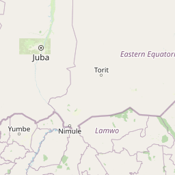
The landscape of Nimule National Park reflects the broader topographical character of the South Sudan-Uganda border region, which sits within the East African plateau system. The terrain consists primarily of savanna grasslands and woodland ecosystems typical of the Nile basin. The area lies at relatively low elevation compared to mountainous regions to the east, placing it within a warm tropical environment. The landscape likely includes seasonal watercourses and riparian corridors that follow the drainage patterns flowing toward the Nile system. The vegetation structure probably consists of a mosaic of open grassland areas interspersed with denser woodland thickets, a pattern common across this portion of East Africa. The park's relatively flat to gently rolling terrain distinguishes it from the more mountainous protected areas found in neighboring countries, while its position along an international border gives it a distinctive geographical framing.
Nimule National Park ecosystems, habitats, and plant life
The ecosystems within Nimule National Park represent the savanna biome that covers much of South Sudan and extends across the broader East African region. The park likely supports a mix of grassland habitats, woodland areas, and potentially riparian zones along watercourses that traverse the protected area. These habitat types together support a diversity of species adapted to the seasonal patterns and environmental conditions of this part of Africa. The ecological importance of the park extends beyond its boundaries through its role in maintaining connectivity with Ugandan landscapes, allowing for wildlife movements that help maintain genetic exchange between populations. The savanna environment experiences distinct wet and dry seasons that shape vegetation patterns and influence wildlife distribution throughout the year.
Nimule National Park wildlife and species highlights
While specific wildlife details are limited in the source material, the park's location within the East African savanna ecosystem suggests it supports populations of large mammals typical of this habitat type. The broader South Sudan region is known for its wildlife populations including various antelope species, buffalo, and smaller mammals. The park's proximity to Uganda indicates potential for species movements between the two countries, maintaining wildlife populations that might otherwise be isolated by international boundaries. Birdlife in the region is likely diverse given the varied habitats present, though specific species documentation would require more detailed survey data.
Nimule National Park conservation status and protection priorities
Nimule National Park represents South Sudan's longest-standing commitment to formal wildlife protection, established decades before many of the country's current conservation challenges emerged. Its IUCN Category II designation places it within the international framework of national parks that prioritize ecosystem protection. The park's transboundary position along the Uganda border gives it additional conservation significance, as it forms part of a potential regional network of protected areas that allow wildlife movements and maintain ecological continuity across national boundaries. Conservation of this area faces challenges common to protected areas in regions that have experienced conflict and political instability, but the persistence of its protected status since 1954 demonstrates the enduring value of this landscape.
Nimule National Park cultural meaning and human context
The South Sudan-Uganda border region has been inhabited by various communities whose livelihoods have historically intersected with the landscapes that now fall within protected areas. While specific indigenous or local community information is not provided in the source material, the broader region is home to communities with traditional connections to the land. The park's location along an international boundary also gives it cultural significance as a zone of interaction between neighboring nations.
Top sights and standout views in Nimule National Park
Nimule National Park stands as South Sudan's oldest national park, representing over seven decades of continuous protection since 1954. The park's 410-square-kilometer extent protects a segment of East African savanna ecosystem along the Ugandan border, creating important transboundary conservation connections. Its classification as IUCN Category II confirms its status as a premier protected area within South Sudan's conservation system. The park provides an important ecological anchor in a region where habitat loss and human pressure have reduced natural spaces.
Best time to visit Nimule National Park
The optimal time to visit Nimule National Park would generally align with the dry season months when wildlife viewing opportunities are typically best across East African savanna parks. The dry season, typically spanning from roughly November through March, tends to concentrate animals around remaining water sources and reduce vegetation density, making wildlife easier to observe. The wet season, from approximately April through October, transforms the landscape with fresh vegetation but can make some areas more difficult to access and wildlife more dispersed. Visitors to the park should check current travel advisories given the broader security considerations that affect travel to parts of South Sudan.