

Mori Atlas logo
National parkKibale National Park

Discover the mapped boundaries and regional context of this vital East African protected area.

Kibale National Park: Uganda's Protected Landscape and National Park Geography

Kibale National Park stands as a significant protected area within Uganda, representing a crucial component of the nation's natural landscapes. As a designated national park, its boundaries encompass a specific geographic scope within East Africa, offering a distinct focus for atlas-based exploration and understanding of protected land distribution. This page delves into the park's identity as a protected landscape, providing essential context for its mapped geography and its place within the broader regional terrain.

Rainforest National ParkPrimate ConservationChimpanzee HabitatEast African ForestWildlife CorridorUganda Parks

Kibale National Park

National park

Park overview

Structured park overview, official facts, and landscape profile for Kibale National Park

Kibale National Park park facts, protected area profile, and essential visitor context
Review the core facts for Kibale National Park, including designation, size, terrain, visitor scale, habitats, and operating context in one park-focused overview.

About Kibale National Park

Kibale National Park occupies a distinctive position in Uganda's protected area network as one of the most ecologically significant forest reserves in East Africa. The park's location in western Uganda, just east of the Rwenzori Mountains, places it within a transition zone that supports remarkable ecological diversity. The park protects the easternmost extent of the Congo Basin forest ecosystem and represents a critical biodiversity corridor that connects the montane forests of the Rwenzori to the savanna ecosystems of Queen Elizabeth National Park. The landscape varies considerably across the park's elevation gradient, with lower elevations supporting more lowland forest character while higher areas display montane forest qualities. This topographical variation creates diverse microhabitats that support the extraordinary species richness for which Kibale is renowned. The park's importance extends beyond biodiversity conservation to scientific research, as the Makerere University Biological Field Station has facilitated decades of primatological studies that have contributed significantly to understanding chimpanzee behavior, ecology, and social dynamics. The forest also plays a critical role in watershed protection for surrounding communities, with numerous streams and rivers originating within the park boundaries.

Quick facts and research context for Kibale National Park

Kibale National Park covers approximately 766 square kilometres in western Uganda near the town of Fort Portal. The park protects moist evergreen rainforest at elevations between 1,100 and 1,600 metres above sea level. It contains one of the highest concentrations of primates in Africa, with 13 documented species including habituated chimpanzees, endangered red colobus, and vulnerable L'Hoest's monkey. The park also supports 325 bird species and approximately 229 tree species. Kibale was gazetted as a forest reserve in 1932 and formally established as a national park in 1993, now managed by the Ugandan Wildlife Authority.

Park context

Deeper park guide and search-rich context for Kibale National Park

Kibale National Park history, landscape, wildlife, and travel context
Explore Kibale National Park through its history, landscape character, ecosystems, wildlife, conservation priorities, cultural context, and seasonal travel timing in a structured park guide built for atlas discovery and search intent.

Why Kibale National Park stands out

Kibale is best known for its population of habituated common chimpanzees, which have been the focus of extensive research and make the park one of Africa's premier chimpanzee tracking destinations. The park contains 13 primate species, the highest diversity of primates in East Africa, and is particularly famous for the endangered Ugandan red colobus and the rare L'Hoest's monkey. The park also protects the last significant expanse of pre-montane forest in eastern Africa and contains well-studied chimpanzee communities that have been observed for decades at the Makerere University Biological Field Station.

Kibale National Park history and protected-area timeline

Kibale National Park traces its formal protection history to 1932 when the area was gazetted as a forest reserve under British colonial administration. The original forest reserve designation reflected the colonial government's interest in managing the valuable timber resources of the region while also acknowledging the ecological significance of the forest. For decades, the reserve operated under a management regime that permitted selective logging while maintaining the overall forest structure. In 1993, following decades of evolving conservation thinking and recognition of the forest's exceptional biodiversity value, the reserve was formally elevated to national park status, granting it the highest level of protection under Ugandan law. This transition reflected a shift from resource extraction priorities to biodiversity conservation as the primary management objective. The establishment of the Makerere University Biological Field Station within the park provided crucial scientific infrastructure that has supported ongoing research and helped inform management decisions. More recently, the park has become a focal point for community-based conservation initiatives that seek to balance the needs of local populations with conservation objectives.

Kibale National Park landscape and geographic character

Kibale National Park presents a landscape defined by its position within the Albertine Rift region, characterized by gentle undulating terrain that rises from approximately 1,100 metres at its lowest points to around 1,600 metres along its higher ridgelines. The forest canopy dominates the visual character of the park, with emergent trees reaching above the general canopy layer. The terrain is dissected by numerous streams and valleys that create a subtly complex topography, with permanent watercourses providing important habitat diversity. Within the forest, there are periodic grassy clearings and swampy areas that break the continuous forest cover, providing important habitat for different species. The forest structure varies with elevation, with lower areas displaying characteristics of lowland evergreen forest while higher elevations show increasing representation of montane forest species. The park lies just east of the massive Rwenzori Mountains, whose presence influences the local climate and creates the moisture conditions that sustain this extensive forest block.

Kibale National Park ecosystems, habitats, and plant life

The ecological character of Kibale National Park is defined by its moist evergreen rainforest, which represents one of the most species-rich forest types in Africa. The park contains approximately 229 tree species, including several endangered timber species such as Cordia millenii, Entandrophragma angolense, and Lovoa swynnertonii. The forest understory is characterized by shade-tolerant shrubs and herbs, with species like Palisota schweinfurthii and Pollia condensata common beneath the canopy, along with ferns and broadleaf grasses. The park is exceptional for containing both lowland and montane forest types within a single protected area, a characteristic that creates extraordinary habitat diversity and supports the remarkable species concentrations found here. The forest represents the easternmost extent of the Congo Basin ecosystem and contains the last significant expanse of pre-montane forest in eastern Africa. This pre-montane character places Kibale in a transitional zone between lowland equatorial forests and true montane formations, creating unique ecological conditions that support species assemblages found nowhere else in the region.

Kibale National Park wildlife and species highlights

Kibale National Park supports one of the highest diversity and concentration of primates in Africa, with 13 documented species making it a globally significant area for primate conservation. The park's flagship species is the common chimpanzee, which exists in well-studied habituated communities that have been the subject of long-term research. The endangered Ugandan red colobus is another primate of particular conservation concern, while the vulnerable L'Hoest's monkey represents a rare species found in relatively few locations. Other primates include the Uganda mangabey, mantled guereza, and blue monkey. Beyond primates, the park supports a diverse mammal community including African elephants that travel between Kibale and Queen Elizabeth National Park, various antelope species such as red and blue duikers, bushbucks, sitatungas, bushpigs, giant forest hogs, common warthogs, and African buffalo. Predators present include leopards, African golden cats, and servals, while smaller carnivores include several mongoose species and two otter species. The avifauna is equally impressive, with 325 bird species recorded including the endemic Kibale ground thrush, olive long-tailed cuckoo, western tinkerbird, African and green-breasted pittas, and grey parrot.

Kibale National Park conservation status and protection priorities

Kibale National Park represents one of the most important conservation areas in East Africa, protecting the last significant expanse of pre-montane forest in the region. The park's establishment created a critical wildlife corridor connecting Kibale to Queen Elizabeth National Park, forming a 180-kilometer passage that enables elephant populations and other wildlife to move between protected areas. The park's primate communities, particularly the habituated chimpanzees, have become flagship species for conservation in Uganda, generating significant ecotourism revenue that supports local communities and provides incentives for protection. Research conducted through the Makerere University Biological Field Station has provided crucial data on forest ecology, primate behavior, and conservation biology that informs management decisions. However, the park faces significant conservation challenges, including population pressure from surrounding communities that have increased sevenfold over the past century, leading to habitat conversion and increased demand for forest resources. Conservation efforts include fire management to enable natural forest regeneration and community-based initiatives that provide alternatives to forest exploitation.

Kibale National Park cultural meaning and human context

The area surrounding Kibale National Park is inhabited primarily by two major ethnic groups: the Batooro and the Bakiga. These communities have historically maintained close relationships with the forest, utilizing its resources for food, fuel, and other subsistence needs under agreements with the Uganda Wildlife Authority. The dramatic population increase around the park over the past century has created significant pressures on the forest boundary, as agricultural expansion and development have encroached on previously forested land. The tourism industry associated with the park has created economic opportunities for local communities, providing jobs and income that have contributed to the population growth by making the area economically attractive. Traditional land use practices, including collection of forest products and small-scale agriculture, continue to shape the relationship between local communities and the protected area.

Top sights and standout views in Kibale National Park

Kibale National Park offers exceptional chimpanzee tracking experiences with habituated communities that tolerate human observation, providing intimate encounters with our closest living relatives. The park contains the highest primate diversity in East Africa, with 13 species including the endangered red colobus and the rare L'Hoest's monkey. The forest protects the last significant pre-montane forest in eastern Africa and creates a vital 180-kilometer wildlife corridor connecting to Queen Elizabeth National Park. The Makerere University Biological Field Station enables ongoing scientific research, making Kibale one of the most studied forest ecosystems on the continent. Bird enthusiasts can observe 325 species, including the Kibale ground thrush found nowhere else on Earth.

Best time to visit Kibale National Park

Kibale National Park can be visited throughout the year, though certain seasons offer distinct advantages for different activities. The dry seasons from December to February and June to August typically provide easier walking conditions on forest trails and increased visibility for wildlife viewing. Chimpanzee tracking is available year-round, though the dry months often make it easier to follow primates as they congregate at water sources. The wet seasons bring lush forest conditions and excellent birdwatching, with migratory species present from November to March. The park's elevation provides relatively moderate temperatures year-round, though morning and evening hours can be cool. Regardless of season, visitors should be prepared for forest conditions and the possibility of rain, as the park's moist evergreen character means precipitation can occur at any time.
Park location guide

Geography guide, regional context, and park location map for Kibale National Park

Kibale National Park park geography, regions, and map view in Uganda
Understand where Kibale National Park sits in Uganda through a broader geographic reading of the surrounding landscape, nearby location context, and its mapped position within the national park landscape.

How Kibale National Park fits into Uganda

Uganda is a landlocked East African nation spanning approximately 241,000 km². It borders five countries and contains part of Lake Victoria, the world's second-largest freshwater lake. The country operates as a presidential republic with Kampala as its capital and largest city.

Wider geography shaping Kibale National Park in Uganda

Uganda is situated in East Africa, bordered by Kenya to the east, South Sudan to the north, the Democratic Republic of the Congo to the west, Rwanda to the southwest, and Tanzania to the south. The southern portion includes a substantial part of Lake Victoria. The terrain features volcanic hills, mountains, and lakes.

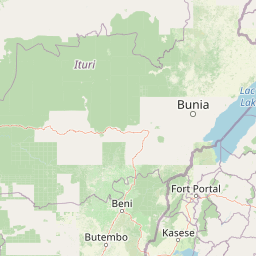
Map view of Kibale National Park

Use this park location map to pinpoint Kibale National Park in Uganda, understand its exact geographic position, and read its mapped placement within the surrounding landscape more clearly.

Pigeon | © OpenStreetMap contributors
Park atlas

Trace the regional geography of East African forests and compare protected areas across the Albertine Rift.

Explore Nearby National Parks and Protected Landscapes Around Kibale National Park, Uganda
Browse additional national parks and protected areas geographically connected to Kibale National Park, tracing the distinct forest ecosystems and diverse primate habitats across Uganda's Albertine Rift region. Comparing these regional conservation landscapes helps identify significant wildlife corridors and uncover the unique natural heritage preserved within East Africa's protected territories.
National parkBundibugyo District

Semuliki National Park: Discover Uganda's Protected Landscape and Regional Geography

Explore mapped boundaries and protected area context.

Semuliki National Park serves as a vital protected area within Uganda, located in the Bundibugyo District. This entry focuses on its identity as a mapped landscape, detailing its protected boundaries and regional geographic significance for users interested in structured atlas exploration and understanding the distribution of conservation lands.

Area
219 km²
Established
1993
IUCN
II
Relief
Lowland
National parkUganda

Rwenzori Mountains National Park: Uganda's Distinctive Glacial National Park Landscape

Mapped terrain and Afro-alpine ecosystems of this East African protected area.

Rwenzori Mountains National Park represents a unique protected landscape in Uganda, known for its iconic glacial peaks and endemic Afro-alpine vegetation. As a UNESCO World Heritage Site, it showcases dramatic terrain ranging from montane forests to permanent glaciers, with Margherita Peak standing as the crown jewel. This park offers a rich geographic context for understanding East African mountain ecosystems and the mapped boundaries of significant conservation areas, providing valuable data for atlas-style exploration.

Area
996 km²
Established
1991
IUCN
VI
Relief
Mountain
National parkUganda

Queen Elizabeth National Park: Mapped Protected Landscape in Uganda's Geography

Explore Uganda's National Park map and terrain.

Queen Elizabeth National Park represents a significant protected landscape within Uganda, offering a rich context for geographic exploration. As a national park, its mapped boundaries define a unique area for understanding the region's natural terrain and landscape character. This destination provides structured data essential for atlas-based discovery, allowing users to analyze its geographic positioning and its role within Uganda's conservation areas.

Area
1,978 km²
Established
1952
IUCN
II
Relief
Mixed relief
National parkKagera Region

Ibanda-Kyerwa National Park: Tanzania's Tri-Border Protected Landscape and Geographic Atlas

Savanna, riparian habitats, and vital regional geography exploration.

Delve into Ibanda-Kyerwa National Park, a recently established national park in Tanzania's Kagera Region. This protected area is distinguished by its critical location at the tri-border with Uganda and Rwanda, with the Kagera River system defining its unique savanna and riparian landscapes. Understanding its mapped boundaries and ecological context provides essential insight into protected land discovery in northwestern Tanzania and its role within the wider regional atlas.

Area
200 km²
Established
2019
IUCN
II
Relief
Highland
National parkKagera Region

Rumanyika-Karagwe National Park: Protected Landscape and Geographic Context in Kagera Region

Explore the mapped boundaries and regional setting of this national park.

Rumanyika-Karagwe National Park serves as a vital protected landscape within the Kagera Region of Tanzania. This entry facilitates a geographic discovery of the park, highlighting its mapped outlines and its role as a national park. Users can gain an understanding of its regional landscape context, providing a solid foundation for atlas-based exploration and appreciating the park's protected area status.

Area
247 km²
Established
2019
IUCN
II
Climate
Tropical
Watercolor illustration of rolling hills, mountains, and a river or lake
National parkDemocratic Republic of the Congo

Virunga National Park: Democratic Republic of the Congo's Premier Protected Landscape

Mapped boundaries and diverse Albertine Rift endemic geography.

Virunga National Park represents a pivotal protected area within the Democratic Republic of the Congo, characterized by an exceptional range of geographic features and vital ecosystems. Its protected landscape includes active volcanoes like Nyiragongo with its lava lake, the towering Rwenzori Mountains, and diverse lowland savannas. This atlas-focused entry highlights the park's unique position in the Albertine Rift, crucial for numerous endemic species and offering significant insight into regional geography and protected land context.

Area
7,800 km²
Established
1925
IUCN
II
Relief
Mountain
National parkRwanda

Volcanoes National Park: Rwanda's Protected Volcanic Landscape and Regional Geography

Mapped park boundaries and East African geographic context.

Delve into Volcanoes National Park, a crucial protected area within Rwanda's northwest. This page offers detailed insight into its geography, highlighting the volcanic terrain and mapped boundaries that define this important national park. Understand its placement within the Virunga Mountains and its contribution to the natural landscape of East Africa, providing a foundation for atlas-based exploration of protected lands.

Area
160 km²
Established
1925
IUCN
II
Relief
Mountain
National parkEastern Province

Akagera National Park National Park: Protected Landscape Geography and Atlas Exploration

Understand the mapped terrain and regional context of Akagera National Park.

Akagera National Park, designated as a national park, represents a vital protected landscape within Rwanda's Eastern Province. This atlas-focused entry provides essential geographic context, highlighting the park's mapped boundaries and natural terrain. Explore Akagera National Park as a key element in regional geography and a focal point for understanding protected land distribution.

Area
1,122 km²
Established
1934
Visitors
34K annual
Relief
Mixed relief

Common questions about visiting, size, designation, and location context for Kibale National Park

Kibale National Park FAQs for park facts, access, geography, and protected area context
Find quick answers about Kibale National Park, including protected-area facts, park geography, trail and visitor context, and how the park fits into its surrounding country and regional landscape.
MoriAtlas Explorer

Continue Your Protected Areas Search Across the Global Atlas

Deepen your exploration by continuing the structured search for national parks and protected areas worldwide. Utilize the comprehensive filtering capabilities to compare different conservation landscapes and refine your understanding of global park geography. Discover more about the distribution and characteristics of protected natural areas.

Global natural geography

