

Mori Atlas logo
Wildlife reserveNkhotakota Wildlife Reserve

A vast sanctuary of miombo woodlands, dambo wetlands, and rugged Great Rift Valley escarpments.

Nkhotakota Wildlife Reserve: Mapping the Protected Landscapes and Geography of Malawi

Nkhotakota Wildlife Reserve stands as the oldest and largest protected wildlife area in Malawi, stretching across 1,800 square kilometres of dramatic Rift Valley terrain. This rugged landscape descends from high escarpments to a narrow lakeside plain, defined by a mosaic of Brachystegia miombo woodlands, seasonal dambo wetlands, and riverine forests. As a focal point for large-scale conservation restoration, the reserve provides critical habitat for recovering mammal populations and over 280 recorded bird species.

miombo woodlanddambo wetlandsGreat Rift ValleyLake Malawiwildlife reserveelephant translocation
A stylized digital illustration of a forested trail winding toward a prominent rocky cliff in a hilly landscape.

Nkhotakota Wildlife Reserve

Wildlife reserve

Park overview

Structured park overview, official facts, and landscape profile for Nkhotakota Wildlife Reserve

Nkhotakota Wildlife Reserve park facts, protected area profile, and essential visitor context

Review the core facts for Nkhotakota Wildlife Reserve, including designation, size, terrain, visitor scale, habitats, and operating context in one park-focused overview.

About Nkhotakota Wildlife Reserve

Nkhotakota Wildlife Reserve is one of the defining protected landscapes of central Malawi. Stretching across roughly 1,800 square kilometres in the Central Region of the country, it sits at the interface between the African Great Rift Valley and the shores of Lake Malawi, and it represents the country's largest and oldest formally designated wildlife reserve. The closest significant town on the lakeshore is Nkhotakota itself, and the reserve's eastern edge looks out over Lake Malawi, while its western boundary rises against forested highland country.

The reserve's landscape is shaped by the geology of the Rift Valley. From the edge of the escarpment at around 1,638 metres above sea level, the land falls steeply eastward through dissected ridges and gorges to a relatively narrow lakeside plain at roughly 500 to 600 metres. Three major rivers, including the Bua, drain this terrain and flow down toward Lake Malawi, creating the mosaic of dry woodland slopes and seasonally wet valley bottoms that defines the park's vegetation pattern.

Ecologically, Nkhotakota belongs firmly to the miombo biome of southern and eastern Africa, with extensive Brachystegia-dominated miombo woodland, open dambo grasslands, riverine forest strips along the larger watercourses, and a small 44-hectare patch of mid-altitude rainforest on Chipata Mountain. This habitat mosaic supports one of the more diverse bird communities in Malawi and historically supported important populations of elephants, hippos, and other large mammals.

In modern times, the reserve has gained recognition less for its size than for what has happened inside it. Heavy poaching, charcoal production, and unsustainable logging hollowed out the wildlife populations through the early 2010s, with the resident elephant herd collapsing to fewer than 100 animals. Since 2015, when the nonprofit African Parks assumed long-term management of the reserve in partnership with the Government of Malawi, the park has been the focus of a continent-wide rewilding effort, including the relocation of more than 500 elephants and over 2,000 other large mammals from Liwonde and Majete, a major follow-up translocation in 2022, and a major investment in ranger-based law enforcement.

Nkhotakota today functions both as a working example of large-scale African reserve restoration and as a scenic wildlife destination in its own right, with growing populations of elephants, hippos, sable, kudu, zebra, and other species, and a bird list that continues to draw ornithologists interested in miombo endemics and Rift Valley escarpment species.

Quick facts and research context for Nkhotakota Wildlife Reserve

Nkhotakota Wildlife Reserve is an approximately 1,800 square kilometre protected area in central Malawi, located near the lakeside town of Nkhotakota along the western shoulder of the Great Rift Valley above Lake Malawi. It is classified as an IUCN Category IV habitat and species management area and is the oldest and largest wildlife reserve in Malawi.

The terrain drops from the Rift Valley escarpment at roughly 1,638 metres down to a narrow lakeside plain at between 500 and 600 metres, carved by three major rivers flowing toward Lake Malawi. Vegetation is dominated by miombo woodland on the dry uplands and dambo wetlands in the valleys, with small patches of riverine forest and mid-altitude rainforest on Chipata Mountain.

Protection and recognition

Documented terrestrial protection scope, management framework, and official recognition records

Nkhotakota Wildlife Reserve Protection Status and International Recognition Facts

Nkhotakota Wildlife Reserve maintains a documented terrestrial protection scope within its designated conservation boundaries. Structured records outline the official protection status and management framework associated with the protected landscape.

Protection details

Protection scope
Terrestrial
Transboundary protection
No
Park context

Deeper park guide and search-rich context for Nkhotakota Wildlife Reserve

Nkhotakota Wildlife Reserve history, landscape, wildlife, and travel context

Explore Nkhotakota Wildlife Reserve through its history, landscape character, ecosystems, wildlife, conservation priorities, cultural context, and seasonal travel timing in a structured park guide built for atlas discovery and search intent.

Why Nkhotakota Wildlife Reserve stands out

Nkhotakota is best known for being Malawi's flagship miombo woodland reserve and for one of the most ambitious elephant and wildlife translocation projects ever carried out in central Africa. After elephant numbers collapsed due to poaching in the early 2010s, African Parks partnered with the Government of Malawi to rebuild the reserve's wildlife base by moving more than 1,300 animals from Liwonde and Majete between 2016 and 2022. The reserve is equally recognized for its rugged Rift Valley escarpment scenery and for its bird diversity, which includes around 280 recorded species, among them several miombo specialists and rare visitors such as the Taita falcon along the escarpment. It is also notable as the only place in Malawi where the rufous trident bat has been recorded.
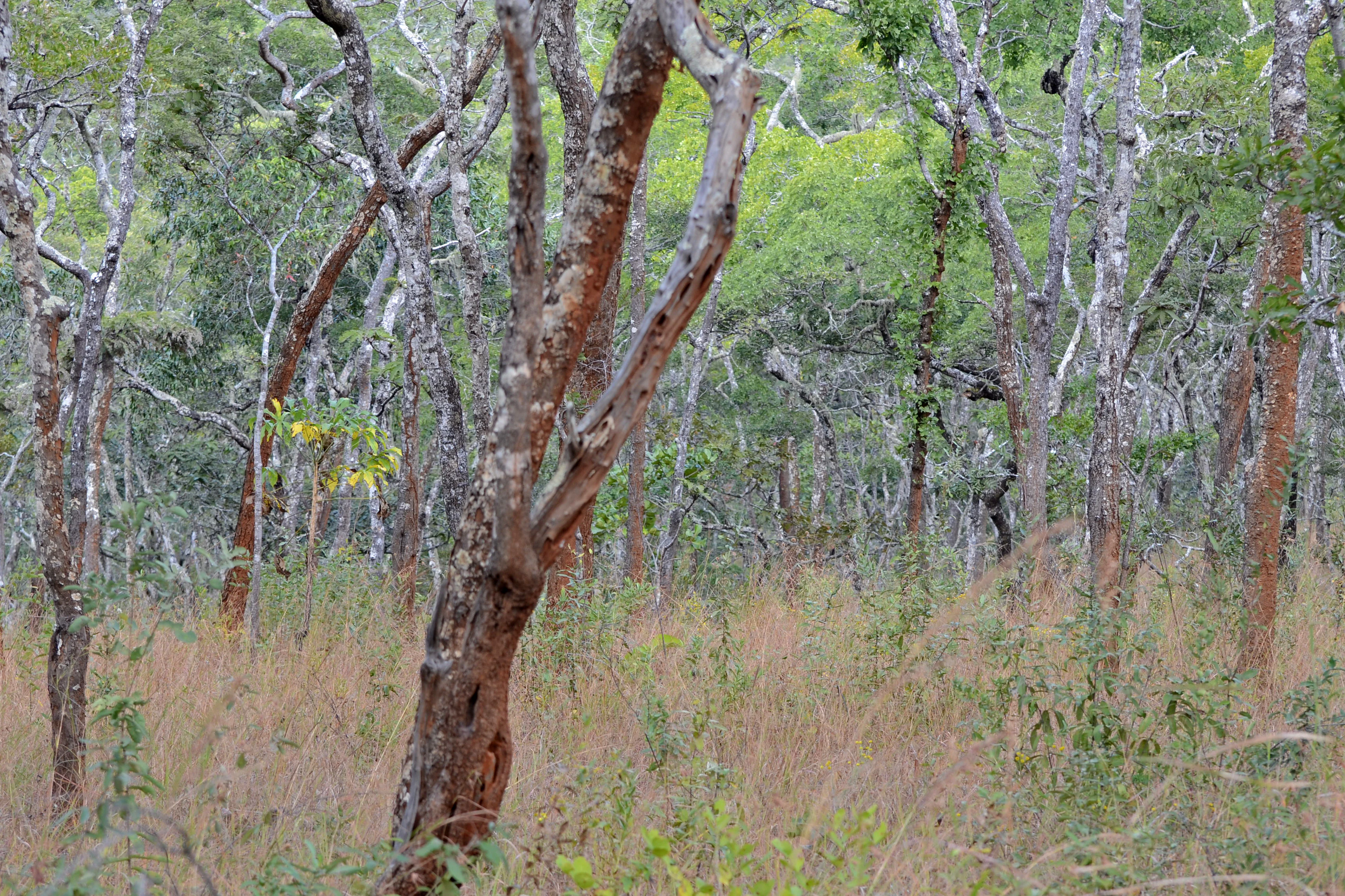
A dense stand of trees with thin, reddish-brown trunks and green canopies rising above dry, tan-colored tall grasses.
Miombo woodland terrain within Nkhotakota Wildlife Reserve.

Nkhotakota Wildlife Reserve history and protected-area timeline

Nkhotakota Wildlife Reserve has been a formally protected area in Malawi for decades, making it the oldest wildlife reserve in the country, but for most of its modern history it has been defined less by long-term management success than by pressure from poaching, charcoal production, and unsustainable logging. These pressures steadily eroded its wildlife populations through the late twentieth and early twenty-first centuries.

In 2012, the Global Environment Facility invested $850,000 through its Effective Management of the Nkhotakota Wildlife Reserve project, focused in particular on the Bua watershed area, to support improved management of the reserve. This marked an early step toward organized conservation investment, but the decisive change came in 2015, when the nonprofit African Parks signed a twenty-year management agreement with the Government of Malawi, administered through the Department of National Parks and Wildlife and the Public Private Partnership Commission, to manage and restore the reserve.

African Parks quickly overhauled law enforcement and anti-poaching operations, hiring and training rangers and rebuilding roads and infrastructure within the reserve. Between July 2016 and August 2017, roughly 500 elephants were relocated from Liwonde National Park and Majete Wildlife Reserve to Nkhotakota in a $1.6 million project funded by Nationale Postcode Loterij, the Wyss Foundation, and other donors, alongside buffalo, eland, impala, kudu, sable antelope, warthog, waterbuck, and zebra. In 2017, the Wyss Foundation committed $65 million to support management of Nkhotakota together with Liwonde, Majete, and Rwanda's Akagera National Park.

A second large translocation in 2022 moved a further 813 animals into the reserve, including 15 hippos, the first time African Parks had relocated hippopotamus as part of a translocation programme. Since 2005, the area has been recognized as a Lion Conservation Unit, and although lions are not yet permanently resident, conservation planners have identified Nkhotakota as having potential to support black rhinoceros, cheetah, lion, and African wild dog in the future. Camera trap surveys in 2019 also confirmed the presence of roan antelope and honey badger, both previously thought to have disappeared locally.

Nkhotakota Wildlife Reserve landscape and geographic character

Nkhotakota sits at the western edge of the East African Rift, where the Great Rift Valley escarpment drops down toward Lake Malawi. The reserve's topography spans an unusually wide vertical range, running from the escarpment crest at around 1,638 metres above sea level down through a rugged belt of dissected slopes to a narrow lakeside plain at roughly 500 to 600 metres elevation.

The terrain is wild and steep, with rough ridges and long slopes cut by rivers and gorges flowing eastward toward Lake Malawi. Three major rivers dominate the drainage, shaping the valleys that produce the reserve's characteristic alternation of dry upland woodland and wet valley-bottom vegetation. From the escarpment, the land falls broadly from west to east, opening out toward the lake and creating broad views over the Rift Valley.

Along the eastern boundary, the reserve meets the shores of Lake Malawi, giving it a small but distinctive lakeside interface. Inland, the topography continues in steep wooded hills and ridges, with occasional more sheltered pockets where denser forest has survived along rivers and on elevated sites such as Chipata Mountain, which still supports a small patch of mid-altitude rainforest.
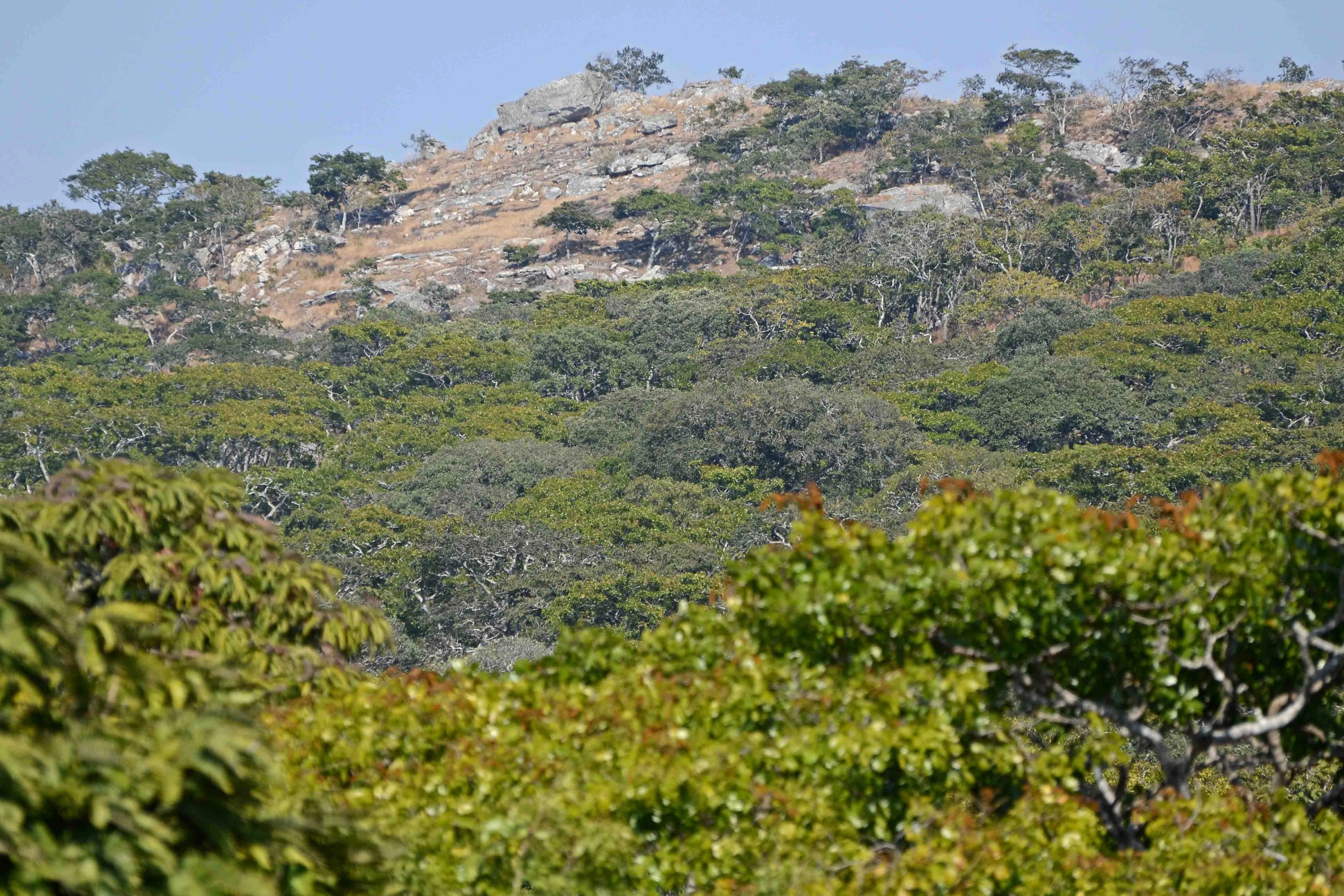
A sunny hillside in Nkhotakota Wildlife Reserve featuring rocky outcrops and patches of dense green woodland under a clear sky.
The hilly, forested terrain of Nkhotakota Wildlife Reserve, characterized by dense miombo woodland.

Nkhotakota Wildlife Reserve ecosystems, habitats, and plant life

Nkhotakota is fundamentally a miombo reserve. The dominant vegetation across most of its 1,800 square kilometres is miombo woodland, characterized by Brachystegia and related tree species and accompanied by long grasslands. This dry woodland environment gives the reserve its characteristic seasonal rhythm, producing broad open vistas under a relatively open canopy in the wet season and a more stark, deciduous character in the dry months.

Intersecting the miombo is a network of dambos, seasonally inundated grassy valleys that act as both ecological corridors and key grazing areas for herbivores. Along the larger rivers, narrow strips of riverine forest create denser, evergreen habitat, and on Chipata Mountain a small patch of around 44 hectares of mid-altitude rainforest survives, providing a distinct ecological island within the broader miombo landscape.

Together, these habitat types give Nkhotakota an unusually layered ecological structure. The miombo uplands support specialist bird and invertebrate communities, while the dambos and riverine corridors sustain higher densities of mammals, and the rainforest patch offers a refuge for moisture-loving species that would otherwise be absent from an otherwise dry-country reserve.

Nkhotakota Wildlife Reserve wildlife and species highlights

Nkhotakota's wildlife story is one of collapse and recovery. Historical records point to a reserve that once supported around 1,500 elephants, large numbers of hippos, and healthy populations of antelope and other herbivores, but consecutive decades of poaching reduced these numbers sharply. By the time African Parks assumed management in 2015, the resident elephant population had fallen to fewer than 100 animals, and other large mammals, including common eland, waterbuck, southern reedbuck, and hippopotamus, had also declined substantially.

Between 2016 and 2022, African Parks relocated more than 520 elephants and over 2,800 other animals from Liwonde National Park and Majete Wildlife Reserve to Nkhotakota, in what is one of the largest concentrated large-mammal restoration efforts attempted in southern Africa. The 2016 to 2017 phase brought in roughly 500 elephants along with buffalo, eland, impala, kudu, sable antelope, warthog, waterbuck, and zebra, while a 2022 translocation added a further 813 animals, including 15 hippos relocated for the first time by African Parks.

The reserve currently supports growing populations of elephants, hippos, buffalo, and a variety of antelope, alongside baboons, leopards, and warthogs. Camera traps in 2019 confirmed that roan antelope and honey badgers, both previously thought locally extinct, are still present, and the reserve has been recognized as a Lion Conservation Unit since 2005, with potential future roles for black rhinoceros, cheetah, lion, and African wild dog.

Nkhotakota is the only location in Malawi where the rufous trident bat has been recorded, adding a distinctive zoological signature to the park's biodiversity profile.

Nkhotakota Wildlife Reserve conservation status and protection priorities

Nkhotakota has emerged as one of the major conservation turnaround stories of recent years in southern Africa. Its significance today is shaped less by its size, impressive as that is, and more by the scale of the ecological recovery that has unfolded since 2015, when African Parks assumed long-term management of the reserve under a twenty-year partnership with the Government of Malawi.

A central part of that recovery has been the translocations from Liwonde National Park and Majete Wildlife Reserve. Between 2016 and 2022, more than 1,300 large mammals were moved into Nkhotakota, including over 520 elephants and several thousand other animals. These translocations were carefully engineered to re-establish breeding populations of elephants, hippos, buffalo, eland, impala, kudu, sable antelope, warthog, waterbuck, and zebra, and they were paired with a parallel investment in law enforcement, ranger training, fencing, and the construction of an internal sanctuary within the reserve.

The reserve's conservation profile is reinforced by its international recognition as a Lion Conservation Unit since 2005, its importance for the only known Malawian population of the rufous trident bat, and its role as a refuge for species such as roan antelope and honey badger that were believed to have disappeared locally. The park also falls within the Bua watershed area, which received targeted Global Environment Facility support beginning in 2012, recognizing the link between wildlife protection and broader landscape and water management.

Conservation planners have identified Nkhotakota as having genuine potential to restore locally extinct black rhinoceros, cheetah, lion, and African wild dog populations, although these reintroductions have not yet been undertaken. As a result, the reserve is now viewed not only as a site for protecting existing biodiversity but as a key node for rebuilding the wildlife communities of central Malawi.

Nkhotakota Wildlife Reserve cultural meaning and human context

Nkhotakota Wildlife Reserve sits within a region of long-standing human settlement along the lakeshore and the surrounding hills, and its modern revival has been closely tied to community-focused conservation and tourism initiatives. The Tongole Wilderness Lodge, opened in May 2011 by British philanthropists working with a Malawian partner, established a charitable arm, the Tongole Foundation, that supports nearby communities and schools, and as of 2012 was working with Malawi's Department of National Parks and Wildlife to address poaching and rebuild populations of buffalo, kudu, sable, and other species.

On the eastern side of the reserve, the Bua River Lodge, opened in 2010 by British expatriate and soil conservationist John Dickinson, combines modest tented accommodation with day trips including visits to Chipata Mountain and its small campsite. Tourism operations such as these have become closely entwined with the reserve's conservation and community engagement efforts, framing Nkhotakota not only as a wildlife refuge but as a working landscape where local livelihoods, charitable investment, and ecological recovery are connected.

Top sights and standout views in Nkhotakota Wildlife Reserve

Nkhotakota's standout qualities include its position as Malawi's largest and oldest wildlife reserve, its dramatic Great Rift Valley escarpment setting above Lake Malawi, and its extensive Brachystegia miombo woodland patchwork with dambo wetlands and a small patch of mid-altitude rainforest on Chipata Mountain. The reserve is also distinguished by the recovery of its elephant population from fewer than 100 animals to more than 600 through major translocations from Liwonde and Majete, and by supporting Malawi's only known population of the rufous trident bat.

Its combination of recovering large-mammal populations, miombo woodland bird diversity of around 280 recorded species, and active rewilding partnerships makes it one of the most ambitious conservation restorat... [truncated]

Best time to visit Nkhotakota Wildlife Reserve

As in much of central Malawi, Nkhotakota experiences a distinct wet season and dry season that strongly shape both access and wildlife viewing. The dry season, broadly running from about May through October, is generally considered the most rewarding period for visiting the reserve: vegetation is thinner, water sources become more predictable, and large mammals, including elephants and other antelope, are easier to observe as they concentrate around remaining water.

The wet season, broadly from November through April, brings heavier rains that can make some of the reserve's rough internal roads difficult to navigate and is also the period when miombo woodland is in leaf and bird activity is at its peak. Birdwatchers visiting for miombo endemics and escarpment species such as the Taita falcon may find this season particularly rewarding, while visitors focused on large mammals generally prefer the drier months when animals are more visible.
Monthly climate preview

Long-term temperature and precipitation averages across the representative coordinate

Nkhotakota Wildlife Reserve Climate Normals and Monthly Weather Patterns

Nkhotakota Wildlife Reserve exhibits a measured annual rhythm of shifting temperatures and precipitation totals based on long-term climate monitoring records. Examining the complete twelve-month profile reveals detailed monthly fluctuations in temperature ranges and rainfall distribution across the reserve.
Annual mean20 °C
15 °C23 °C
Jan21°
Feb21°
Mar21°
Apr20°
May18°
Jun16°
Jul15°
Aug17°
Sep20°
Oct22°
Nov23°
Dec22°
Warmest month
November

23.2 °C

Coolest month
July

15.4 °C

Wettest month
January

9.3 mm/day

Driest month
August

0.1 mm/day

Park location guide

Geography guide, regional context, and park location map for Nkhotakota Wildlife Reserve

Nkhotakota Wildlife Reserve park geography, regions, and map view in Malawi

Understand where Nkhotakota Wildlife Reserve sits in Malawi through a broader geographic reading of the surrounding landscape, nearby location context, and its mapped position within the national park landscape.

How Nkhotakota Wildlife Reserve fits into Malawi

Malawi is a landlocked country in Southeastern Africa. Formerly known as Nyasaland under British colonial rule, it gained independence in 1964 and became a multi-party democracy in 1994. The country is known for Lake Malawi, which comprises about one-fifth of its territory, and is governed as a unitary presidential republic with Lilongwe as its capital.

Wider geography shaping Nkhotakota Wildlife Reserve in Malawi

Malawi is located in Southeastern Africa within the Great Rift Valley. It is bordered by Zambia to the west, Tanzania to the north and northeast, and Mozambique to the east, south, and southwest. The country features highlands and plateaus in the northern and central areas, with the Great Rift Valley system running through the territory.

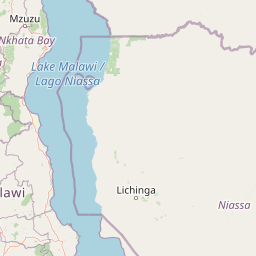
Map view of Nkhotakota Wildlife Reserve

Use this park location map to pinpoint Nkhotakota Wildlife Reserve in Malawi, understand its exact geographic position, and read its mapped placement within the surrounding landscape more clearly.

Pigeon | © OpenStreetMap contributors

Explore protected area imagery, rugged escarpment terrain, and miombo woodland habitats.

Nkhotakota Wildlife Reserve Photos and Scenery: Visualizing Rift Valley Landscapes

Visual records capture the steep Rift Valley escarpment terrain and extensive miombo woodland habitats defining Nkhotakota Wildlife Reserve. Examining field photographs reveals the distinctive topography and protected landscape character spanning Malawi.

A dense stand of trees with thin, reddish-brown trunks and green canopies rising above dry, tan-colored tall grasses.

A park ranger in a green uniform and hat, seen from behind, walking on a reddish dirt path through a forest toward two small, round, thatched-roof huts.

A sunny hillside in Nkhotakota Wildlife Reserve featuring rocky outcrops and patches of dense green woodland under a clear sky.

Park atlas

Compare surrounding regional terrain, wildlife habitats, and connected conservation areas.

Other Parks Near Nkhotakota Wildlife Reserve and Regional Protected Landscapes

Browsing other parks near Nkhotakota Wildlife Reserve allows visitors to examine related conservation initiatives across the Great Rift Valley. Comparing regional protected areas provides broader geographic context into miombo woodland ecosystems and wildlife translocations.
Watercolor painting of a tranquil scene featuring soft-hued trees, rolling hills, and a water's edge, characterized by a light and airy artistic style.
Wildlife reserveNorthern Region
About 27 km away#1 closest

Northwest

Chikangawa Forest Reserve: Mapping Malawi's Viphya Mountains Protected Wildlife Landscape

Explore montane forest ecosystems and exotic pine plantations

Chikangawa Forest Reserve stands as a major protected block within Malawi's Northern Region. The area covers extensive mountain ridges where native montane vegetation interweaves with significant man-made pine plantations. This geographic atlas entry provides insight into the reserve's role as a watershed protector and its unique position across the Viphya Plateau.

Area
1,147.8 km²
Established
1948
Relief
Mountain
Climate
Tropical
Wildlife reserveMalawi
About 109 km away#2 closest

North

Vwaza Marsh Wildlife Reserve: Geographic Atlas and Protected Landscape Overview

A lowland wilderness reserve in northern Malawi

Spanning roughly 1,000 square kilometers, Vwaza Marsh Wildlife Reserve provides a unique contrast to the surrounding highlands through its flat topography, seasonal wetlands, and dense mopane forests. This destination serves as a vital corridor for large mammals moving across the border, offering a window into the complex interplay of water-focused ecology and savanna-woodland habitats in Southeastern Africa.

Area
1,000 km²
IUCN
IV
National parkMalawi
About 118 km away#3 closest

North

Nyika National Park: Malawi National Park Atlas Exploration and Protected Landscape

Discover geographic context and mapped boundaries of this protected area.

Nyika National Park serves as a core entry for understanding Malawi's protected areas and natural landscapes through an atlas lens. Explore the park's designation as a national park, its geographic positioning within Malawi, and the mapped context that defines its protected status. This detail page provides a foundational view for appreciating the park's landscape and its contribution to the regional protected lands overview.

Area
3,134 km²
Established
1966
IUCN
II
Relief
Highland
National parkZambia
About 142 km away#4 closest

Southwest

Lukusuzi National Park: Zambia's Protected National Park Geographic Context

Mapped protected area and regional landscape identity for Lukusuzi.

Gain detailed insights into Lukusuzi National Park, a key protected area in Zambia, through its geographic setting and mapped boundaries. This page provides essential context for understanding the park's landscape character and its significance within the national park atlas. Explore the fundamental protected-area geography of this distinct Zambian natural landscape.

IUCN
II
Access
Access unknown
Scope
Terrestrial
National parkMalawi
About 143 km away#5 closest

Southwest

Kasungu National Park: Protected Landscape and Geographic Atlas of Central Malawi

Explore Miombo woodlands and dambo grasslands across its mapped terrain.

Kasungu National Park is a key protected area in Malawi, offering insights into the geography of Central Malawi's savanna landscapes. This national park, covering over 2,300 square kilometres, is defined by its characteristic Miombo woodland interspersed with dambo grasslands and riverine habitats. Its location near the Zambian border provides a critical conservation corridor, making it an important entity for understanding regional protected land distribution and landscape ecology within the atlas.

Area
2,316 km²
Established
1970
IUCN
II
Relief
Mixed relief
Nature reserveCentral Region
About 150 km away#6 closest

South

Ntchisi Mountain Forest Reserve: Geographic Overview and Protected Landscape Analysis

Nature reserve featuring isolated montane rainforest and high-elevation grassland in Malawi

Ntchisi Mountain Forest Reserve stands as a compact highland landmark within Malawi's Central Region, hosting a rare enclave of montane rainforest. This protected area offers an essential study in landscape zonation, where rift-influenced moisture supports diverse forest patches amidst a broader expanse of miombo woodland and montane grasses.

Area
97.12 km²
Established
1924
Relief
Mountain
Climate
Tropical
National parkZambia
About 153 km away#7 closest

North

Nyika National Park: A Zambian National Park for Mapped Landscape Discovery

Explore its protected area boundaries and regional geographic context.

Nyika National Park in Zambia is a critical protected landscape offering valuable insights for geographic exploration. As a national park, its mapped terrain and regional context provide a distinct point of study within the country's atlas. Users can investigate the park's specific geographic features and its contribution to Zambia's conservation landscapes, enriching their understanding of protected areas.

Relief
Highland
Climate
Subtropical
Access
Moderate access
Scope
Terrestrial
National parkMuchinga Province
About 157 km away#8 closest

West

North Luangwa National Park: National Park Protected Landscape and Regional Geography

Mapped boundaries and geographic context within Muchinga Province.

North Luangwa National Park is a designated national park offering critical insights into Zambia's protected landscapes. This page provides an atlas-driven view of its geographic scope, emphasizing its mapped boundaries and its position within Muchinga Province. Explore the fundamental geography and protected area context that defines North Luangwa National Park for structured landscape discovery.

Area
4,636 km²
Established
1972
IUCN
II
Relief
Mixed relief

Common questions about visiting, size, designation, and location context for Nkhotakota Wildlife Reserve

Nkhotakota Wildlife Reserve FAQs for park facts, access, geography, and protected area context

Find quick answers about Nkhotakota Wildlife Reserve, including protected-area facts, park geography, trail and visitor context, and how the park fits into its surrounding country and regional landscape.
MoriAtlas Explorer

Continue Your Protected Areas Search Across the Global Atlas

Deepen your exploration by continuing the structured search for national parks and protected areas worldwide. Utilize the comprehensive filtering capabilities to compare different conservation landscapes and refine your understanding of global park geography. Discover more about the distribution and characteristics of protected natural areas.

Global natural geography
