Mori Atlas logo
National parkNortheast Greenland National Park

Explore the vast geographic scope and mapped boundaries of the world's largest national park.

Northeast Greenland National Park: Unrivaled Arctic Wilderness and Protected Landscape

Discover Northeast Greenland National Park, an immense protected landscape covering over 972,000 square kilometers of pristine Arctic wilderness. This national park offers an unparalleled look at ice-sheet interiors, rugged coastal fjords, and the northernmost landmasses on Earth. It serves as a critical sanctuary for iconic Arctic wildlife, representing one of the planet's most remote and ecologically significant protected areas, ideal for atlas-driven geographic exploration.

world's largest national parkArctic wildernesspolar desertGreenlandmusk oxen habitatice sheet
Illustrated iceberg with green and white tones floating in water, with mountains and a pastel sky in the background.

Northeast Greenland National Park

National park

Park overview

Structured park overview, official facts, and landscape profile for Northeast Greenland National Park

Northeast Greenland National Park park facts, protected area profile, and essential visitor context
Review the core facts for Northeast Greenland National Park, including designation, size, terrain, visitor scale, habitats, and operating context in one park-focused overview.

About Northeast Greenland National Park

Northeast Greenland National Park represents a landmark in global conservation — not only as the world's largest national park but as one of the most significant protected wilderness areas remaining on Earth. The park occupies the entire northeastern portion of Greenland, spanning from the ice-capped interior to a dramatic coastline etched with deep fjords and scattered islands. This vast territory encompasses geographic regions including King Frederick VIII Land and King Christian X Land, protecting a landscape that remains among the most sparsely populated and least visited on the planet. The park shares borders with the Sermersooq municipality in the south and the Avannaata municipality in the west, with the boundary along the ice cap following the 45th meridian west. What makes this park extraordinary is not merely its size but the completeness of the Arctic ecosystem it preserves — from the continental ice sheet to coastal marine environments, from polar desert terrain to the habitats that support some of the largest remaining populations of Arctic megafauna. The park is the second-largest second-level subdivision of any country in the world, surpassed only by the Qikiqtaaluk Region in Nunavut, Canada.

Quick facts and research context for Northeast Greenland National Park

The park covers 972,000 km² (375,000 mi²), making it larger than Tanzania and exceeding the area of 166 of the world's 195 countries. It is the northernmost national park globally and the first national park created in the Kingdom of Denmark. The interior consists primarily of the Greenland Ice Sheet, while the coast features extensive ice-free areas including Peary Land in the far north, King Frederick VIII Land, and King Christian X Land. No permanent residents exist within the park boundaries, though a handful of seasonal research stations are maintained along the coast and on the ice sheet.

Park context

Deeper park guide and search-rich context for Northeast Greenland National Park

Northeast Greenland National Park history, landscape, wildlife, and travel context
Explore Northeast Greenland National Park through its history, landscape character, ecosystems, wildlife, conservation priorities, cultural context, and seasonal travel timing in a structured park guide built for atlas discovery and search intent.

Why Northeast Greenland National Park stands out

Northeast Greenland National Park is renowned for its extraordinary size and its status as one of Earth's last great wilderness areas. The park protects what is estimated to be 40% of the world's musk oxen population, between 5,000 and 15,000 individuals, making it globally significant for this iconic Arctic species. Its coastal waters support significant populations of polar bears and walrus, while the ice-free terrain provides critical habitat for Arctic wildlife. The park encompasses the Franz Josef Fjord system and extends to the northernmost land reaches of Greenland, offering a landscape of dramatic glacier-carved fjords, polar desert environments, and the northernmost terrestrial ecosystems on the planet.

Large rectangular iceberg floating in calm water with reflection, under partly cloudy sky with distant landmasses visible
Iceberg in Fohn Fjord within Northeast Greenland National Park

Northeast Greenland National Park history and protected-area timeline

The park was originally established on May 22, 1974, carved from the northern, practically uninhabited portion of the former Ittoqqortoormiit Municipality in East Greenland. In 1988, the park underwent a significant expansion, adding 272,000 square kilometers to its territory when the northeastern section of the former Avannaa county (North Greenland) was incorporated, bringing the park to its present size. In January 1977, the park received designation as an international biosphere reserve, recognition of its exceptional ecological value. The park remains under oversight of the Greenland Department of Environment and Nature, with the Sirius Patrol serving as the park's policing agency based at Daneborg. Historical research camps on the ice sheet — Eismitte and North Ice — famous from early 20th-century Greenland expeditions — fall within the boundaries of the present-day park.

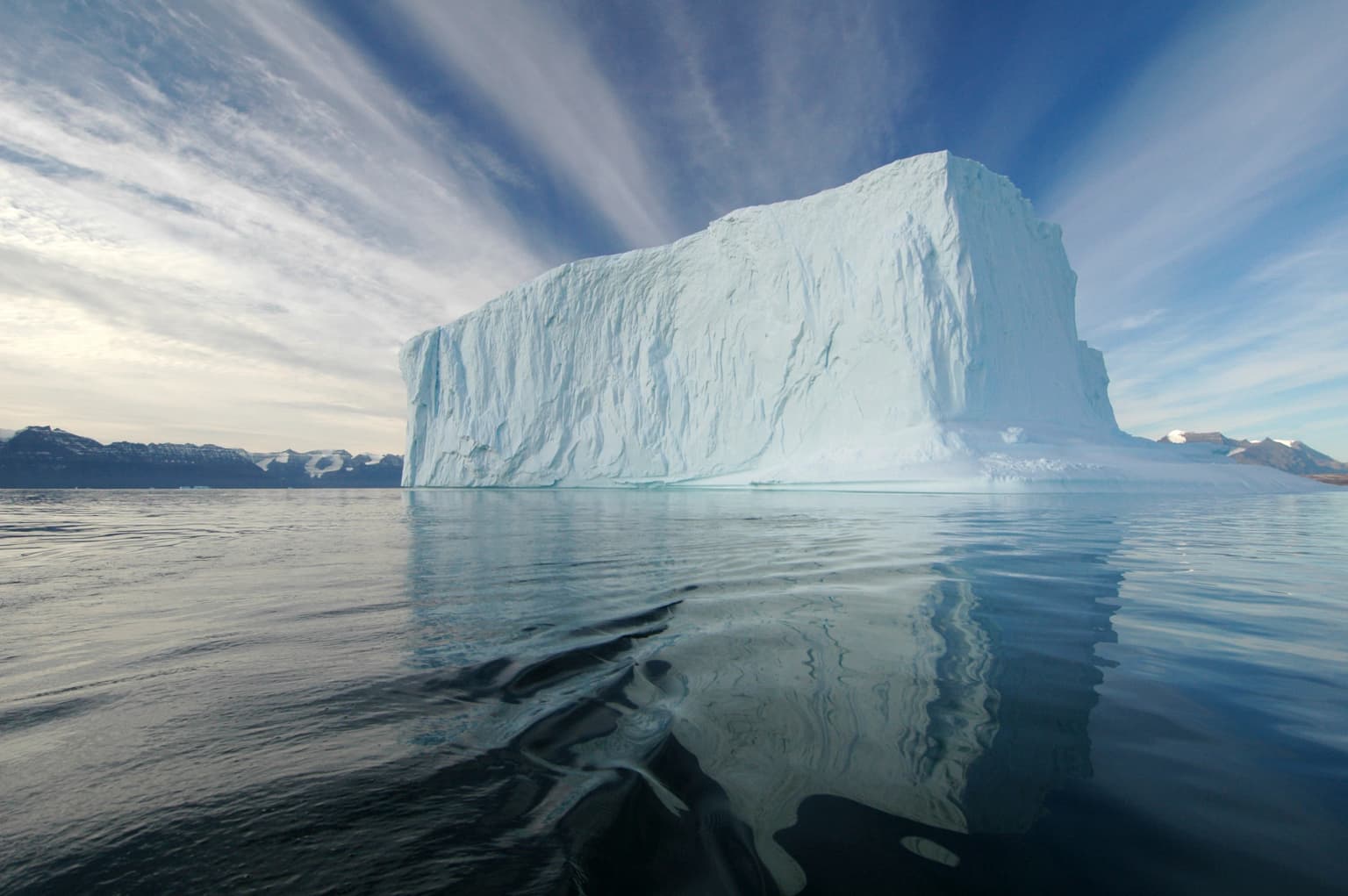
Northeast Greenland National Park landscape and geographic character

The park's geography presents a striking contrast between its ice-covered interior and its rugged coastal terrain. The vast interior is dominated by the Greenland Ice Sheet, one of Earth's two major ice caps, but the coastal regions and northern areas feature extensive ice-free terrain. Peary Land in the far north represents one of the most northerly land areas on the planet. The coastline is characterized by dramatic fjords, including the renowned Franz Josef Fjord, where glacier-carved walls rise sharply from the sea, often tinted orange by reflected sunlight. The landscape includes polar desert environments, mountain ranges, coastal lowlands, and numerous islands along the southeastern coast such as Ymer Island. The terrain reflects the powerful erosive action of ancient glaciers, creating a landscape of steep cliffs, U-shaped valleys, and scattered islands that dot the maritime approach to this remote coast.

Northeast Greenland National Park ecosystems, habitats, and plant life

This Arctic park protects some of the most significant wildlife populations in the high Arctic. The park supports an estimated 5,000 to 15,000 musk oxen — approximately 40% of the global population — making it critically important for the survival of this species. The coastal regions provide essential habitat for substantial populations of polar bears and walrus, while the marine environment supports ringed seal, bearded seal, harp seal, and hooded seal, as well as narwhal and beluga whale. The terrestrial ecosystem includes Arctic fox, stoat, collared lemming, Arctic hare, and a small but significant population of Greenland wolf. The park's designation as an international biosphere reserve reflects recognition of these ecological values and the need to preserve this Arctic ecosystem in its entirety.

Northeast Greenland National Park wildlife and species highlights

The park's wildlife represents one of its most remarkable attributes, with populations of Arctic megafauna that are globally significant. Musk oxen thrive in the ice-free coastal areas and northern terrain, representing one of the largest remaining herds on Earth. Polar bears den along the coastlines and hunt among the pack ice, while walrus congregate on coastal haul-outs in significant numbers. Marine mammals including several seal species, narwhal, and beluga whale inhabit the surrounding waters. The bird population is diverse and includes great northern diver, barnacle goose, pink-footed goose, common eider, king eider, gyrfalcon, snowy owl, sanderling, rock ptarmigan, and raven — species adapted to the harsh Arctic conditions and dependent on the coastal and terrestrial habitats the park protects.

Northeast Greenland National Park conservation status and protection priorities

As the world's largest national park and the first created in the Kingdom of Denmark, Northeast Greenland National Park represents a commitment to protecting one of Earth's last great wilderness areas. Its designation as an international biosphere reserve in 1977 reflects recognition of its outstanding ecological significance. The park protects habitat essential for species that are globally threatened elsewhere, particularly musk oxen, polar bears, and Arctic marine mammals. The park's strict protection status (IUCN Category II) ensures preservation of this vast Arctic ecosystem in its natural state for future generations. The extremely low visitor numbers — exceeding only 500 yearly — mean that the park remains among the most undisturbed protected areas on Earth.

Northeast Greenland National Park cultural meaning and human context

The park has no permanent human population, though historical research camps including Eismitte and North Ice — famous from early 20th-century Greenland expeditions — fall within its boundaries. A small number of seasonal research stations are maintained, including Daneborg (headquarters of the Sirius Patrol), Danmarkshavn weather station, Station Nord military base, Mestersvig military outpost with its gravel runway, Zackenberg research station, and Summit Camp on the ice sheet. These installations represent the only human presence in this vast wilderness, with the Sirius Patrol responsible for park enforcement and monitoring.

Top sights and standout views in Northeast Greenland National Park

The park's extraordinary scale offers an Arctic wilderness experience unmatched anywhere else on the planet. Its protection of approximately 40% of the world's musk oxen population represents one of the most significant conservation achievements for this species. The dramatic glacial landscapes of Franz Josef Fjord and other coastal fjords provide visual drama of exceptional quality. As the northernmost national park in the world, it offers access to ecosystems found nowhere else. The park's status as an international biosphere reserve and its extremely limited human footprint ensure that these Arctic landscapes remain among the most pristine on Earth.

Best time to visit Northeast Greenland National Park

The brief Arctic summer from June to August offers the most accessible visiting window, when temperatures rise enough for limited outdoor activity and wildlife is most active. During this period, the midnight sun provides continuous daylight, allowing extended exploration of the landscape. The winter months from November to February bring extreme cold and complete darkness, while shoulder seasons offer opportunities for aurora borealis viewing. The park's extreme remoteness and limited access mean visits require substantial planning and are typically conducted through organized scientific expeditions or specialized adventure tourism operators.

Park location guide

Geography guide, regional context, and park location map for Northeast Greenland National Park

Northeast Greenland National Park park geography, regions, and map view in Greenland
Understand where Northeast Greenland National Park sits in Greenland through a broader geographic reading of the surrounding landscape, nearby location context, and its mapped position within the national park landscape.

How Northeast Greenland National Park fits into Greenland

Greenland is the world's largest island and an autonomous territory within the Kingdom of Denmark, located between the Arctic and Atlantic oceans. The territory has a small land border with Canada on Hans Island and is characterized by extensive ice coverage, Arctic climate, and a population concentrated in coastal settlements.

Wider geography shaping Northeast Greenland National Park in Greenland

Greenland is situated between the Arctic Ocean to the north and the Atlantic Ocean to the south, lying east of the Canadian Arctic Archipelago. The territory shares a 1.2-kilometer border with Canada on Hans Island in the Nares Strait. The landscape is dominated by the Greenland Ice Sheet, which covers approximately 80% of the island's surface. The highest point reaches 3,700 meters elevation.

Map view of Northeast Greenland National Park

Use this park location map to pinpoint Northeast Greenland National Park in Greenland, understand its exact geographic position, and read its mapped placement within the surrounding landscape more clearly.

Pigeon | © OpenStreetMap contributors

Location context for Northeast Greenland National Park

AvannaataSermersooq

Explore the dramatic Arctic scenery, pristine wilderness habitats, and expansive protected landscapes of Greenland's colossal national park.

Northeast Greenland National Park Photos: Iconic Arctic Landscapes, Glacial Fjords, and Remote Scenery
Browse a rich collection of Northeast Greenland National Park photos to understand its unique visual identity and remote Arctic environments. These images provide essential context for appreciating the vast glacial fjords, ice-free terrain, and critical wildlife habitats within the world's largest national park.

Large rectangular iceberg floating in calm water with reflection, under partly cloudy sky with distant landmasses visible

A glacier in Franz Josef Fjord surrounded by snow-capped mountains and orange-tinted ice reflecting light

Park atlas

Trace the geographic spread of Arctic protected landscapes and compare other remote wilderness areas.

Explore Nearby National Parks and Protected Areas in the Arctic Region, Beyond Northeast Greenland National Park
From Northeast Greenland National Park, explore additional national parks and protected areas within the broader Arctic region, tracing diverse polar desert and coastal fjord landscapes. Compare the unique geographic context and conservation efforts of various remote Arctic wildernesses, enhancing your understanding of global protected-area distribution.
National parkSvalbard

Forlandet National Park: High Arctic Protected Landscape and Global Wildlife Limits

Explore mapped geography and protected ecosystem boundaries in Svalbard.

Forlandet National Park stands as a crucial element in the Arctic atlas, safeguarding the island of Prins Karls Forland and its surrounding marine territories. As the world's most northerly national park, it showcases a unique High Arctic landscape defined by stark coastal cliffs and vital waters supporting specialized wildlife. This protected area is recognized for harboring the most extreme northern populations of seals and common guillemots, making it a significant site for understanding polar ecosystems and conservation efforts within the Svalbard region.

Area
4,647 km²
Established
1973
IUCN
II
Relief
Lowland
National parkSvalbard

Nordvest-Spitsbergen National Park: Protected Arctic Landscape and Geographic Atlas

Explore unique hot springs, glacial terrain, and polar expedition history.

Nordvest-Spitsbergen National Park, a protected national park in Norway's Svalbard archipelago, showcases dramatic Arctic geography. This page details its mapped landscapes, from volcanic terrains and glacial valleys to its famed northernmost hot springs. Discover the park's protected area status, its role in regional geography, and its historical significance for polar exploration, providing a rich context for atlas-based exploration.

Area
9,914 km²
Established
1973
IUCN
II
Relief
Mixed relief
Watercolor illustration of a fjord with mountains, trees, and water bodies
National parkSpitsbergen

Nordre Isfjorden National Park: Arctic Coastal Protected Landscape

Discover Spitsbergen's mapped fjord geography and wildlife.

Nordre Isfjorden National Park on Spitsbergen offers a compelling view into a pristine Arctic environment. This protected national park encompasses dramatic coastal cliffs, tundra terrain, and the biologically rich waters of Isfjorden. It is renowned for supporting immense seabird colonies that rely on the nutrient-dense fjord, making it a significant site for understanding high Arctic ecosystems and marine protected areas.

Area
2,954 km²
Established
2003
IUCN
II
Relief
Lowland
National park

Indre Wijdefjorden National Park: Arctic Steppe and Fjord Protected Landscape Exploration

Mapped protected boundaries and unique terrain in Svalbard.

Discover the unique High Arctic steppe and dramatic fjord landscape of Indre Wijdefjorden National Park, a protected area in Svalbard, Norway. This park safeguards a rare ecosystem with endemic plant species, offering exceptional insights into Arctic geography and protected land conservation. Explore its mapped boundaries and distinct terrain, a key destination for atlas-based landscape discovery.

Area
1,127 km²
Established
2005
IUCN
II
Relief
Mountain
National parkSvalbard

Sassen, Bünsow Land National Park: A Mapped Arctic Glacial Landscape in Svalbard

Explore protected boundaries and polar terrain.

Sassen, Bünsow Land National Park, located in the heart of Spitsbergen, Norway, showcases a quintessential Arctic wilderness defined by its expansive glacial features and deeply incised valleys. This protected area, part of the Svalbard archipelago, offers rich geographic context through its mapped terrain, highlighting glacial processes that have shaped the landscape. Discover the unique polar environment and the significance of this national park within the broader Norwegian Arctic atlas.

Area
1,230 km²
Established
2003
IUCN
II
Relief
Mountain
National park

Sør-Spitsbergen National Park: Mapping Norway's Pristine Arctic Protected Landscape

Explore glacial terrain, tundra ecosystems, and significant seabird colonies.

Delve into Sør-Spitsbergen National Park, a cornerstone of Arctic protected areas within Norway's Svalbard archipelago. This extensive national park showcases raw glacial terrain, expansive ice caps, and sparse tundra valleys, offering a unique geographic context. It is globally recognized for its vast seabird colonies, particularly the dense nesting sites of thick-billed guillemots, and Ramsar-protected wetlands. Understanding Sør-Spitsbergen National Park through its mapped boundaries and landscape features provides critical insight into Arctic conservation and natural processes.

Area
8,504 km²
Established
1973
IUCN
II
Relief
Mixed relief
National park

Jökulsárgljúfur National Park: Explore Iceland's Volcanic Canyon and Glacial River Protected Landscape

Mapped geography and terrain of a key northern Iceland protected area.

Jökulsárgljúfur National Park, located in northern Iceland, is celebrated for its striking volcanic canyon landscape carved by the powerful Jökulsá á Fjöllum glacial river. This protected area showcases a terrain shaped by ancient glacial outburst floods and volcanic forces, featuring notable geological formations like the Hljóðaklettar echo rocks and iron-colored hills. Understanding Jökulsárgljúfur National Park provides crucial insight into the unique regional geography and the atlas-driven exploration of Iceland's preserved natural heritage.

Relief
Mountain
Access
Remote access
Scope
Terrestrial
Water
Minor water
National park

Snæfellsjökull National Park: Mapped Volcanic Terrain and Protected Landscape Identity

Discover the geographic context of Iceland's glacier volcano.

Snæfellsjökull National Park on the Snæfellsnes Peninsula is a prime example of Iceland's protected lands, defined by the iconic Snæfellsjökull glacier volcano. This page details the park's volcanic terrain, from expansive lava fields to dramatic sea cliffs, offering an atlas-driven exploration of its unique geographic features. Understand its significance as a protected area and its place within the broader landscape of western Iceland through detailed mapping and geographic data.

Established
2001

Common questions about visiting, size, designation, and location context for Northeast Greenland National Park

Northeast Greenland National Park FAQs for park facts, access, geography, and protected area context
Find quick answers about Northeast Greenland National Park, including protected-area facts, park geography, trail and visitor context, and how the park fits into its surrounding country and regional landscape.
MoriAtlas Explorer

Continue Your Protected Areas Search Across the Global Atlas

Deepen your exploration by continuing the structured search for national parks and protected areas worldwide. Utilize the comprehensive filtering capabilities to compare different conservation landscapes and refine your understanding of global park geography. Discover more about the distribution and characteristics of protected natural areas.

Global natural geography