

Mori Atlas logo
National parkNyanga National Park

Mapping the protected area boundaries and natural terrain of this national park.

Nyanga National Park: Protected Landscape and Geographic Context in Zimbabwe

Nyanga National Park stands as a significant protected area within Zimbabwe, offering a gateway to understanding the country's natural landscapes. This park's defined boundaries and geographic setting in Southeast Africa are crucial for exploring its unique terrain. Through its designation as a national park, Nyanga National Park provides a focal point for atlas-driven discovery, allowing for detailed examination of its mapped context and regional landscape features. Discover the geographical essence of this protected land.

Eastern HighlandsMontane ecosystemsMountain parksEndemic speciesWetlands and riversAfromontane forest

Nyanga National Park

National park

Park overview

Structured park overview, official facts, and landscape profile for Nyanga National Park

Nyanga National Park park facts, protected area profile, and essential visitor context

Review the core facts for Nyanga National Park, including designation, size, terrain, visitor scale, habitats, and operating context in one park-focused overview.

About Nyanga National Park

Nyanga National Park lies in the north of Zimbabwe's Eastern Highlands, a mountainous region that forms a natural boundary with Mozambique. The park's high elevation and proximity to the Indian Ocean moisture belt create a distinctive montane environment quite different from the rest of Zimbabwe. Rolling downland covered in grassland and scattered woodland dominates most of the terrain, while the eastern slopes support dense Afromontane rainforest. The park serves as a critical watershed, with rivers flowing north to the Zambezi Basin and south through the Pungwe River system. Visitors encounter a landscape of green hills, perennial rivers, granite outcrops, and dramatic waterfalls. The area's relative remoteness and high elevation have helped preserve both natural ecosystems and cultural heritage sites. The park's expansion over decades, particularly the late 1990s acquisitions that nearly doubled its size, has protected important montane forest and headwater regions that are ecologically significant for the broader region.

Quick facts and research context for Nyanga National Park

Nyanga National Park occupies the highest terrain in Zimbabwe within the Eastern Highlands region. The park was established in 1926 through Cecil Rhodes' bequest and remains one of the country's oldest protected areas. Mount Nyangani rises to 2,593 metres as Zimbabwe's highest peak, while Mutarazi Falls at 762 metres is the nation's tallest waterfall. The park features Afromontane forest on eastern slopes, montane grasslands, and pockets of rare Mulanje cypress. Five dams provide recreational opportunities, and the area contains significant archaeological sites from the 15th to 17th century Ziwa culture.

Protection and recognition

Mapping the historical boundaries, terrestrial scope, and designation records since 1926.

Documented Protection Status and Terrestrial Designation of Nyanga National Park

Researchers and conservation explorers can review the official terrestrial protection status and established historical records of Nyanga National Park. Examining the 1926 designation timeline and registered conservation metrics helps clarify the regional land management framework in Zimbabwe.

Protection details

Protection scope
Terrestrial
Designated year
1926
Transboundary protection
No
Park context

Deeper park guide and search-rich context for Nyanga National Park

Nyanga National Park history, landscape, wildlife, and travel context

Explore Nyanga National Park through its history, landscape character, ecosystems, wildlife, conservation priorities, cultural context, and seasonal travel timing in a structured park guide built for atlas discovery and search intent.

Why Nyanga National Park stands out

Nyanga National Park is best known for containing Zimbabwe's highest mountain and tallest waterfall, making it a unique high-altitude protected area in the region. The park protects critical populations of two endemic species, the blue duiker and Samango monkey, found nowhere else in the world outside the Eastern Highlands. Its montane rainforest ecosystems support unusual flora including tree ferns and the endemic Nyanga aloe. The park also preserves significant archaeological sites of the Ziwa people, including stone-walled forts and pit structures dating from the 15th to 17th centuries.

Nyanga National Park history and protected-area timeline

Nyanga National Park traces its origins to the late colonial period when Cecil Rhodes acquired the core area as a private estate with ambitions of growing apples and raising sheep. After his death, the land was bequeathed to the nation, establishing Rhodes Inyanga National Park in 1926 as one of Zimbabwe's first protected areas. The original park borders extended further north than today, though portions were sold in the 1970s before some land was recovered in the early 1980s. The park underwent major expansion in the late 1990s through purchases of the Inyanga Block and Kwaraguza farms, adding important montane rainforest areas and the source regions of the Kairezi River and Nyama Falls to the north and east of Mount Nyangani. In 2014, Nyazengu farm was incorporated, completing formal protection of Mount Nyangani and the Pungwe River headwaters. The park was renamed Nyanga to reflect the correct local pronunciation, dropping the colonial-era Inyanga designation.

Nyanga National Park landscape and geographic character

The park is dominated by Mount Nyangani, a prominent granite and dolerite mountain that rises 2,593 metres above sea level as Zimbabwe's highest peak. The surrounding terrain consists of rolling downland, often lightly wooded, interspersed with valleys, streams, and dramatic rock formations. Dolerite sills and sandstone outcrops form cliffs and ridges, particularly on the higher peaks, while the granite-dolerite contact zones frequently create waterfalls. The landscape includes five recreational dams: Rhodes Dam, Mare Dam, Lake Gulliver, Purdon Dam, and Udu Dam, all stocked with trout. The southern area features the Pungwe Gorge, a densely wooded ravine where the Pungwe River drops 240 metres, and the nearby Mutarazi Falls plunge 762 metres into the Honde River valley. The Troutbeck Plateau and Ziwa hills add additional topographical variation to this mountainous terrain.

Nyanga National Park ecosystems, habitats, and plant life

Nyanga's vegetation belongs to the Eastern Zimbabwe montane forest-grassland mosaic, an ecoregion of montane grasslands and shrublands. The Afromontane rainforest occurs primarily on eastern leeward slopes and in steeper valleys on west-facing aspects, dominated by Syzygium species. Westward-facing slopes support woodlands of dwarf msasa, while copses of Mulanje cypress survive in fire-protected areas. Tree ferns are particularly notable, with the common tree fern on moorlands and the forest tree fern in rainforests. The Nyanga aloe occurs on higher ground. However, the park faces significant invasive species pressure; black wattle and pine have spread extensively since introduction, with an estimated 40% of the park invaded by 1988. Park authorities maintain an ongoing eradication programme against these alien species.

Nyanga National Park wildlife and species highlights

The park supports a remarkable diversity of mammals, including species that occasionally range in from the Mozambique lowlands such as buffalo and lion. More commonly observed are kudu, reedbuck, klipspringer, and various other antelope species. Predators present include leopard and hyaena. The park holds particular conservation significance for two endemic species: the blue duiker and Samango monkey, neither found outside the Eastern Highlands region. The African clawless otter is common in the upper Kairezi River. The Inyangani river frog, an endangered amphibian, inhabits rocky fast-flowing streams in montane grassland. The park's dams and streams support populations of rainbow trout, brown trout, and brook trout, originally stocked from departmental hatcheries.

Nyanga National Park conservation status and protection priorities

Nyanga National Park protects critical montane ecosystems that are unique within Zimbabwe. The Afromontane forests and grasslands represent a biodiversity hotspot with several endemic species, most notably the blue duiker and Samango monkey which occur nowhere else in the world. The park protects vital watersheds, with rivers flowing to both the Zambezi Basin and the Pungwe system, serving downstream agricultural communities in Mozambique. The protection of Mount Nyangani and river headwaters, completed through the 2014 incorporation of Nyazengu farm, ensures the integrity of these hydrological systems. Conservation challenges include invasive species management, with black wattle and pine requiring ongoing eradication efforts across significant portions of the park.

Nyanga National Park cultural meaning and human context

The park contains significant archaeological sites from the 15th to 17th century, representing the culture of the Ziwa people who inhabited the uplands. Ruins include homesteads centred on pit structures, likely used as cattle-pens, and larger hill-top settlements known as Forts. Three sites are accessible to tourists: Chawomera Fort above the Nyyangombe River, Nyangwe Fort near Mare Dam (the most extensive and best-preserved), and a reconstructed pit structure near park headquarters with an associated site museum. Associated features include extensive agricultural terracing and irrigation furrows, along with evidence of iron extraction supporting the agricultural technology. The core areas were once Cecil Rhodes' private estate, where he spent his final years; his homestead now houses the Rhodes Museum and Rhodes Nyanga Hotel.

Top sights and standout views in Nyanga National Park

Nyanga National Park combines high-altitude mountain scenery with unique ecological assets and cultural heritage. The summit climb of Mount Nyangani offers panoramic views across the park and into Mozambique. Mutarazi Falls, Zimbabwe's highest waterfall, drops dramatically from the escarpment. The endemic blue duiker and Samango monkey populations draw conservation interest. Historical sites include Ziwa-era forts and reconstructed pit structures. The five stocked dams provide fly-fishing opportunities, while rivers free of bilharzia allow safe swimming. Hiking trails lead to waterfalls, ruins, and mountain viewpoints throughout the park.

Best time to visit Nyanga National Park

The Eastern Highlands experiences a subtropical highland climate with distinct wet and dry seasons. The dry season from April to October typically offers clearer skies and more stable conditions for hiking and outdoor activities, though mountain weather can change rapidly year-round. The wet season from November to March brings heavier rainfall, particularly on eastern slopes, but also lusher green landscapes and fuller waterfalls. Temperature decreases significantly with elevation; conditions on Mount Nyangani can be markedly cooler than the park entrance areas. Visitors planning summit hikes should be prepared for variable mountain weather regardless of season.

Monthly climate preview

Long-term precipitation patterns and temperature ranges across the highland terrain

Nyanga National Park Climate Profile and Long-Term Weather by Month

Climatological records at the representative highland elevation reveal a distinct seasonal rhythm, showing peak precipitation around December and cool, dry trends during June and July. Exploring the complete twelve-month climate profile provides detailed average temperatures and daily precipitation rates across the annual cycle.
Annual mean17 °C
12 °C21 °C
Jan20°
Feb19°
Mar19°
Apr17°
May14°
Jun12°
Jul12°
Aug14°
Sep17°
Oct20°
Nov21°
Dec20°
Warmest month
November

20.5 °C

Coolest month
July

11.9 °C

Wettest month
January

9 mm/day

Driest month
August

0.4 mm/day

Park location guide

Geography guide, regional context, and park location map for Nyanga National Park

Nyanga National Park park geography, regions, and map view in Zimbabwe

Understand where Nyanga National Park sits in Zimbabwe through a broader geographic reading of the surrounding landscape, nearby location context, and its mapped position within the national park landscape.

How Nyanga National Park fits into Zimbabwe

Zimbabwe is a landlocked nation in Southeast Africa located between the Zambezi and Limpopo rivers. The country has a population of roughly 17 million people and uses English, Shona, and Ndebele as its primary languages. Once the site of the ancient Kingdom of Zimbabwe and the city of Great Zimbabwe, it gained independence from the United Kingdom in 1980.

Wider geography shaping Nyanga National Park in Zimbabwe

Zimbabwe is located in Southeast Africa between the Zambezi River to the north and the Limpopo River to the south. It is landlocked, bordered by South Africa, Botswana, Zambia, and Mozambique. The terrain includes highlands, savanna, and the Zambezi valley.

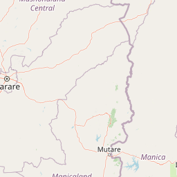
Map view of Nyanga National Park

Use this park location map to pinpoint Nyanga National Park in Zimbabwe, understand its exact geographic position, and read its mapped placement within the surrounding landscape more clearly.

Pigeon | © OpenStreetMap contributors

Location context for Nyanga National Park

Nyanga District
Park atlas

Compare surrounding park geography and protected landscapes in Zimbabwe's Eastern Highlands.

Other National Parks and Protected Areas Near Nyanga National Park

Continue your exploration from Nyanga National Park to discover other national parks and protected areas across Zimbabwe's Eastern Highlands. Compare their unique montane ecosystems, waterfall landscapes, and conservation focuses to understand the regional spread of protected natural areas.
National parkMozambique
146 km away#1 closest

East

Gorongosa National Park: Mozambique National Park with Diverse Rift Valley Ecosystems

Mapped protected area, savanna, and montane rainforest landscapes.

Gorongosa National Park is a premier protected area situated in Mozambique's Great African Rift Valley. This vast national park showcases an extraordinary range of natural landscapes, including extensive floodplains, acacia savannas, and rare montane rainforests within dramatic limestone gorges. Its geographic diversity is matched by its compelling narrative of ecological restoration, making it a significant site for understanding protected land dynamics and regional geography.

Area
3,770 km²
Established
1960
IUCN
II
Relief
Mixed relief
National parkManica Province
About 154 km away#2 closest

South

Chimanimani National Park: Geographic Atlas of Mozambique's Highland Protected Landscapes

Mountain wilderness and transfrontier conservation in Manica Province

Investigate the complex topography of Chimanimani National Park, where the rugged Chimanimani Mountains create a unique highland ecosystem. This data-driven overview highlights the park's role as a major protected territory in eastern Mozambique, documenting its mountain ridges, expansive buffer zones, and role in cross-border conservation geography.

Area
656 km²
Established
2020
IUCN
II
Relief
Mountain
National parkZimbabwe
About 162 km away#3 closest

South

Chimanimani National Park: Geographic Context and Mapped Protected Landscapes of Zimbabwe

A study of montane mountain terrain and transfrontier conservation geography.

Chimanimani National Park encompasses one of southern Africa's most distinctive mountain environments, where sharp ridges and deep valleys support exceptional plant endemism. The protected area forms a significant mountainous corridor within the Eastern Highlands, offering a structured look at how elevation influences local Afromontane ecology and broader landscape connectivity.

Area
155 km²
Established
1949
Relief
Mountain
Climate
Subtropical
National parkTete Province
About 261 km away#4 closest

North

Magoe National Park: A National Park in Tete Province for Geographic and Landscape Exploration

Discover the mapped boundaries and regional geography of this protected area.

Magoe National Park serves as a crucial national park within Tete Province, providing a defined space for exploring regional geography and landscape features. This entry focuses on understanding the park's protected status and its mapped territories, offering valuable context for atlas and geographic research. Examine its location and boundaries to appreciate its role as a protected natural landscape within Mozambique.

Area
3,559 km²
Established
2013
Scope
Terrestrial
Water
Major water bodies
Wildlife reserveNsanje District
About 284 km away#5 closest

Northeast

Mwabvi Wildlife Reserve: Mapping the Protected Landscapes of the Nsanje District

Geography, woodland terrain, and regional biodiversity.

Located in the southernmost Nsanje District of Malawi, Mwabvi Wildlife Reserve encompasses a unique convergence of dry Brachystegia woodland, sandstone hills, and open savanna grasslands. This protected area offers a deep look into the varied topographies of the Lower Shire region, providing a comprehensive understanding of the reserve's historic ecological importance and its current role in regional conservation.

Area
135 km²
Established
1953
IUCN
IV
Relief
Upland
National parkMalawi
About 296 km away#6 closest

Northeast

Lengwe National Park: Malawi's Protected Landscape Atlas and Geographic Context

Mapped natural terrain and protected area boundaries in Malawi.

Lengwe National Park offers a focused look into Malawi's protected natural areas. As a designated national park, its geographic significance is highlighted through mapped boundaries and an understanding of the surrounding regional terrain. This entry provides essential context for exploring its identity as a protected landscape within southeastern Africa, contributing to a broader atlas of conservation areas.

Area
887 km²
Established
1970
IUCN
II
Climate
Tropical
Wildlife reserveMalawi
About 321 km away#7 closest

Northeast

Majete Wildlife Reserve: Geographic Atlas and Protected Area Map of Southern Malawi

Savanna landscapes and Shire River valley ecology

Majete Wildlife Reserve represents a premier example of habitat restoration in the Shire River valley. Spanning 700 square kilometers of varied terrain, the reserve protects a mosaic of riparian forest and savanna that has been carefully managed to sustain Big Five wildlife. Gain insight into the regional geography, protected landscape boundaries, and conservation history of this essential Malawian wildlife sanctuary.

Area
700 km²
Established
1955
IUCN
IV
Visitors
7K annual
National parkMozambique
About 357 km away#8 closest

South

Zinave National Park: A Mozambique National Park with Diverse Woodland and Savanna Landscapes

Explore its mapped terrain, riverine forests, and savanna ecosystems.

Zinave National Park in Mozambique is a significant protected area spanning 4,000 square kilometers. Its landscape comprises a rich variety of ecosystems, including miombo woodlands, mopane-dominated areas, acacia savannas, and distinct riverine forests along the Save River. This national park is strategically positioned within the Greater Limpopo Transfrontier Park, highlighting its importance for regional wildlife corridors and conservation geography. The terrain offers a unique insight into the transitional ecological zones of southern Africa, showcasing diverse natural habitats and mapping potential for its protected boundaries.

Area
4,000 km²
Established
1973
IUCN
II
Relief
Lowland

Common questions about visiting, size, designation, and location context for Nyanga National Park

Nyanga National Park FAQs for park facts, access, geography, and protected area context

Find quick answers about Nyanga National Park, including protected-area facts, park geography, trail and visitor context, and how the park fits into its surrounding country and regional landscape.
MoriAtlas Explorer

Continue Your Protected Areas Search Across the Global Atlas

Deepen your exploration by continuing the structured search for national parks and protected areas worldwide. Utilize the comprehensive filtering capabilities to compare different conservation landscapes and refine your understanding of global park geography. Discover more about the distribution and characteristics of protected natural areas.

Global natural geography
