
Rivers
Park geography
Analyzing the protected landscape boundaries, regional distribution, and natural features.
Comprehensive Geographic Profile and Mapped Terrain of Nyerere National Park in Tanzania
Examine the detailed geographic structure of Nyerere National Park, covering an area of 30,893 square kilometers across the Morogoro and Lindi regions of Tanzania. This profile maps the integrated wetland, riverine, and forest habitats along with major water features such as the Rufiji and Great Ruaha rivers.
Related tags
national parkwildlife sanctuarysavanna ecosystemriver deltabig five
Tanzania's vast wilderness sanctuary named after the nation's founding father
Nyerere National Park
Nyerere National Park is Tanzania's largest national park and one of the world's largest wildlife sanctuaries, spanning approximately 30,893 square kilometers in southeastern Tanzania. The park occupies portions of Liwale District in Lindi Region, southwestern Pwani Region, northeastern Ruvuma Region, and southeastern Morogoro Region. This vast protected area, roughly the size of Belgium, remains largely in a wild state with minimal human alteration. The park is carved from the northern portion of the historic Selous Game Reserve and was officially established as a national park in 2019, named in honor of Mwalimu Julius Kambarage Nyerere, Tanzania's first President. The park is managed by the Tanzania National Parks Authority and features the Rufiji River, Tanzania's largest river system, which supports extensive mangrove forests at its delta and provides critical habitat for hippos and crocodiles.
- Location
- Tanzania
- Park type
- National park
- Established
- 2019
- Area
- 30,893 km²
Location overview
Regional administrative footprint and coastal classification in Tanzania
Nyerere National Park Geographic Location and Regional Setting
Nyerere National Park is situated in Tanzania, spanning parts of the Morogoro Region and Lindi Region. The protected wilderness carries a coastal park designation among its official geographic attributes.
- Countries
- Tanzania
- Regions
- Lindi Region, Morogoro Region
- Primary location
- Tanzania
- Geographic setting
- Coastal
Boundary and coordinates
Interactive boundary geometry, land area, and spatial coordinate limits
Nyerere National Park Boundary Map and Geographic Extent Explorer
Mapped park boundaries provide precise spatial context for exploring territorial outline and spatial configuration. Accompanying geographical measurements outline total land area, coordinate limits, and regional span.
- Boundary area
- 29,314.7 km²
- Boundary perimeter
- 1,486 km
- Northernmost point
- 7.2921° S
- Southernmost point
- 10.442° S
- Easternmost point
- 38.5249° E
- Westernmost point
- 36.0892° E
- Geographic centre
- 9.0387° S, 37.1287° E
- North–south span
- 348.4 km
- East–west span
- 267.9 km
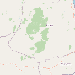
Terrain and natural features
Explore recorded rivers, lakes, and mixed relief classifications across the protected landscape
Nyerere National Park Terrain and Named Natural Features
Nyerere National Park contains mixed relief classifications alongside multiple recorded rivers, lakes, and reservoirs within its boundaries. Linked feature cards supply specific names, types, and spatial relationships for each recorded natural feature.
Selected named natural features
Lakes
Lake Manze
Ponds
Hippo Pool
Rivers
Ulanga River
Rivers
Great Ruaha River
Lakes
Lake Mzizima
Environmental setting
Stored tropical climate zones, mixed relief, and dominant water features
Nyerere National Park Environmental Classifications and Physical Settings
Recorded landscape features, habitat types, and forest cover classifications serve as complementary frameworks for reading the physical setting of Nyerere National Park. Connected atlas destinations link these broad environmental categories directly to related protected areas.
- Relief
- Mixed relief
- Climate
- Tropical
- Water
- Water-dominated
- Forest cover
- Mostly forested
- Seasonality
- Year-round
Landscape features
Forest · Grassland · Rivers · Wetland · Coast
Habitat types
Wetland · Riverine habitat · Tropical forest · Savanna · Coastal habitat
Park atlas
Map surrounding protected areas and compare their geography, extending outward from Nyerere National Park.
Explore Related National Parks and Protected Areas Near Nyerere National Park, Tanzania
Continue your exploration of Tanzania's protected areas after Nyerere National Park, browsing a curated list of nearby national parks and significant protected landscapes. A geographic lens helps compare diverse terrains, river systems, and savanna ecosystems, highlighting the regional spread of conservation efforts.
National parkKilolo District
About 37 km away#1 closest
Northwest

Udzungwa Mountains National Park: Kilolo District Protected Area & Landscape Atlas
Explore mapped boundaries and regional geography for this Tanzanian national park.
Udzungwa Mountains National Park serves as a vital protected area within Kilolo District, offering a specific point of geographic focus for atlas exploration. Users can investigate its mapped boundaries and understand its role within the regional landscape context. This detailed entry provides essential data for comprehending the park's protected status and its contribution to Tanzania's network of natural areas.
- Area
- 1,990 km²
- Established
- 2012
- IUCN
- II
- Relief
- Mountain
National parkMorogoro Region
About 62 km away#2 closest
North
Mikumi National Park: East African Savannah Protected Landscape in Morogoro Region
Mapped boundaries and regional geography for a key Tanzanian national park.
Mikumi National Park, a vital protected area in Tanzania's Morogoro Region, offers a classic savannah experience with iconic baobab trees and diverse wildlife populations. This national park is distinguished by its extensive alluvial plains, shaped by the Mkata River basin, and its significant role as a wilderness corridor connecting with the larger Selous Game Reserve. The park's terrain includes Malundwe Mountain and views of the Uluguru Mountains, providing a rich geographic backdrop for understanding East African protected lands and their atlas-style distribution.
- Area
- 3,230 km²
- Established
- 1964
- IUCN
- II
- Visitors
- 41.7K annual
Nature reserveMozambique
99 km away#3 closest
South

Niassa Reserve Nature Reserve: Mozambique's Expansive Protected Wilderness
Mapping the vast miombo woodlands and endemic species.
Niassa Reserve, a sprawling nature reserve in northern Mozambique, represents one of the largest miombo woodland ecosystems on Earth. Its diverse terrain encompasses dense forests, open savannahs, and riparian zones, making it a vital habitat for unique wildlife and a significant landmark in regional geography. The reserve's protected status and immense scale offer unparalleled opportunities for atlas-style exploration of its landscape and conservation importance.
- Area
- 42,000 km²
- Established
- 1954
- IUCN
- IV
- Relief
- Mixed relief
National parkTanga Region
About 155 km away#4 closest
Northeast
Saadani National Park: Protected Landscape and Geographic Context in Tanga Region
Explore the mapped boundaries and regional geography of this Tanzanian national park.
Saadani National Park represents a distinct protected landscape within the northern Tanzanian coast, specifically situated in the Tanga Region. This entry offers a focused exploration of the park's geographic features, its mapped protected area boundaries, and its intrinsic connection to the regional natural terrain. Delve into the atlas-level details that define Saadani National Park, providing crucial context for understanding its ecological and geographic significance.
- Area
- 1,062 km²
- Established
- 2005
- IUCN
- II
- Visitors
- 15.4K annual
National parkSouth Zanzibar Region
About 165 km away#5 closest
Northeast
Jozani Chwaka Bay National Park: A Protected Landscape within the South Zanzibar Region
National Park geography and mapped protected area.
Delve into Jozani Chwaka Bay National Park, a key protected area situated in Tanzania's South Zanzibar Region. This canonical page offers a structured view of the park's geography, its mapped boundaries, and its role as a national park. Understand its landscape context and its significance for detailed geographic discovery and atlas-based exploration.
- Area
- 50 km²
- Established
- 2004
- IUCN
- II
- Climate
- Tropical
National parkTanzania
186 km away#6 closest
Northwest
Ruaha National Park: Tanzania National Park, Protected Landscape and Geographic Atlas
Mapped boundaries and regional landscape context for Ruaha National Park.
Explore the protected landscape of Ruaha National Park in Tanzania. This page provides detailed mapping of its boundaries and offers insights into its geographic setting. Understand its significance as a national park within the atlas of protected areas, focusing on its natural terrain and regional context without travel logistics.
- Area
- 20,226 km²
- Established
- 1964
- IUCN
- II
- Visitors
- 21.3K annual
National parkMalawi
230 km away#7 closest
Southwest

Nyika National Park: Malawi National Park Atlas Exploration and Protected Landscape
Discover geographic context and mapped boundaries of this protected area.
Nyika National Park serves as a core entry for understanding Malawi's protected areas and natural landscapes through an atlas lens. Explore the park's designation as a national park, its geographic positioning within Malawi, and the mapped context that defines its protected status. This detail page provides a foundational view for appreciating the park's landscape and its contribution to the regional protected lands overview.
- Area
- 3,134 km²
- Established
- 1966
- IUCN
- II
- Relief
- Highland
National parkNjombe Region
About 245 km away#8 closest
West
Kitulo National Park: National Park within Njombe Region's Geographic Atlas
Mapped protected area boundaries and regional landscape context.
Kitulo National Park represents a distinct national park within the geographic atlas of Tanzania's Njombe Region. This page offers a focused exploration of its protected landscape identity, highlighting its mapped boundaries and contributing to a broader understanding of regional geography. It is designed for users seeking detailed, atlas-centric information about Kitulo National Park's specific natural landscape and its position within the surrounding terrain.
- Area
- 413 km²
- Established
- 2005
- IUCN
- II
- Visitors
- 409 annual
MoriAtlas Explorer
Continue Exploring Nyerere National Park's Extensive Protected Landscape and River Systems
Delve deeper into the geographic significance and protected area context of Nyerere National Park. Understand its place within Tanzania's broader landscape, tracing the mapped boundaries and diverse ecosystems that define this immense conservation territory and its ecological importance for regional geography.
Browse next
Global natural geography
Explore related park routes
Explore MoriAtlas Global ParksBrowse All MoriAtlas ParksGlobal Park Map DiscoveryMoriAtlas: Browse All CountriesBrowse All MoriAtlas ContinentsNational Park Environment AtlasGrand Canyon National Park AtlasYellowstone National Park AtlasYosemite National Park Atlas and GeographySerengeti National Park AtlasGalápagos National Park Protected LandscapeBanff National Park Geography and AtlasKruger National Park Atlas EntryUluṟu-Kata Tjuṯa National Park AtlasExplore Uluru-Kata Tjuta National Park GeographyPlitvice Lakes National Park AtlasFiordland National Park Protected LandscapeGreat Smoky Mountains National Park AtlasAfghanistan National Parks and Protected AreasAlbania National Parks and Protected AreasAlgeria National Parks and Protected AreasAmerican Samoa National Parks and Protected AreasAndorra National Parks and Protected AreasAngola National Parks and Protected AreasAntarctica National Parks and Protected AreasAntigua and Barbuda Park List