

Mori Atlas logo
Protected landscapePaisaje protegido Laguna de Castillos

Examining the coastal lagoon topography, native ombú woodlands, and wetland ecological boundaries

Paisaje protegido Laguna de Castillos: A Comprehensive Atlas of Protected Rocha Landscapes

The Paisaje protegido Laguna de Castillos represents a critical protected landscape within the Rocha department of eastern Uruguay. This expansive coastal ecosystem comprises 8,264 hectares of open water, freshwater marshes, and rare native woodlands. The site provides a unique opportunity to map the interaction between the Laguna de Castillos, the Valizas Creek hydrological system, and the extensive stands of native ombú trees found across the coastal plains.

protected landscapecoastal lagoonombú forestnative woodlandwetlandbirdwatching

Paisaje protegido Laguna de Castillos

Protected landscape

Park overview

Structured park overview, official facts, and landscape profile for Paisaje protegido Laguna de Castillos

Paisaje protegido Laguna de Castillos park facts, protected area profile, and essential visitor context

Review the core facts for Paisaje protegido Laguna de Castillos, including designation, size, terrain, visitor scale, habitats, and operating context in one park-focused overview.

About Paisaje protegido Laguna de Castillos

The Paisaje protegido Laguna de Castillos occupies a prominent place among Uruguay's recently formalized protected areas. Covering about 8,264 hectares around the Laguna de Castillos in Rocha department, the area combines a large coastal lagoon, marshlands, and one of the country's most ecologically significant native woodlands. The site stretches roughly 20 kilometers along the eastern margin of the lagoon, where ombú trees form the dominant landscape feature along with surrounding native species.

Ecologically, the protected landscape represents a rare convergence of freshwater lagoon, coastal wetland, and dryland forest systems. The Valizas Creek connects the lagoon to the broader coastal landscape of Rocha, supporting a diverse aquatic and palustrine environment. This hydrological connection shapes both the wildlife patterns and the vegetation structure of the area, allowing amphibian, fish, and bird communities to thrive in tandem with terrestrial forest species.

The site's cultural and conservation history is long-standing. Long before its formal inclusion in the National System of Protected Areas in 2020, the lagoon region had been recognized as a fauna refuge in 1966. That earlier designation drew attention to the importance of preserving both the ombú forest and the lagoon ecosystems, particularly as surrounding agricultural and coastal development pressures grew in eastern Uruguay. The current protected landscape designation reflects a broader understanding of the area as an integrated system of forest, water, and wildlife rather than a narrowly defined reserve.

Beyond its ecological value, the protected landscape has become a focal point for environmental education and conservation in the region. Visitors, rangers, and researchers continue to explore the relationships between native vegetation, waterbird populations, and the rare freshwater species that depend on the lagoon's seasonal cycles. As one of Uruguay's most recently formalized coastal protected areas, it now serves as both a conservation asset and a window into the natural heritage of the Rocha coast.

Quick facts and research context for Paisaje protegido Laguna de Castillos

Paisaje protegido Laguna de Castillos is a protected landscape designation covering approximately 8,264 hectares around the Laguna de Castillos, in the department of Rocha, Uruguay. The area has been part of Uruguay's National System of Protected Areas since 2020, established through executive decree. Historically, the site was designated as a fauna refuge in 1966, reflecting its long-recognized ecological value.

Administratively, the protected landscape falls under Uruguay's environmental and natural resource authorities and centers on the lagoon, its fringing woodlands, and associated wetlands. The area is closely linked to the Valizas Creek, which connects it to the broader coastal system of Rocha.

Protection and recognition

Examine documented terrestrial protection scope and management parameters.

Paisaje protegido Laguna de Castillos Protection Status and Framework

Paisaje protegido Laguna de Castillos holds a documented terrestrial protection scope within regional conservation records. Structured administrative parameters and management criteria define the official designation framework for the protected area.

Protection details

Protection scope
Terrestrial
Transboundary protection
No
Park context

Deeper park guide and search-rich context for Paisaje protegido Laguna de Castillos

Paisaje protegido Laguna de Castillos history, landscape, wildlife, and travel context

Explore Paisaje protegido Laguna de Castillos through its history, landscape character, ecosystems, wildlife, conservation priorities, cultural context, and seasonal travel timing in a structured park guide built for atlas discovery and search intent.

Why Paisaje protegido Laguna de Castillos stands out

The protected landscape is best known for sheltering Uruguay's largest continuous grouping of ombú trees, a 20-kilometer-long stand along the eastern shore of the Laguna de Castillos. These ombúes form a distinctive ecosystem alongside native coronilla, tala, espinillo, ceibo, and arrayán species. It is equally recognized as a stronghold of birdlife, with more than 250 recorded species and seasonal gatherings of black-necked swans, as well as an increasing presence of Chilean flamingos. The combination of coastal lagoon, wetlands, and native forest gives the area a particularly rich ecological identity within Uruguay's protected-area network.
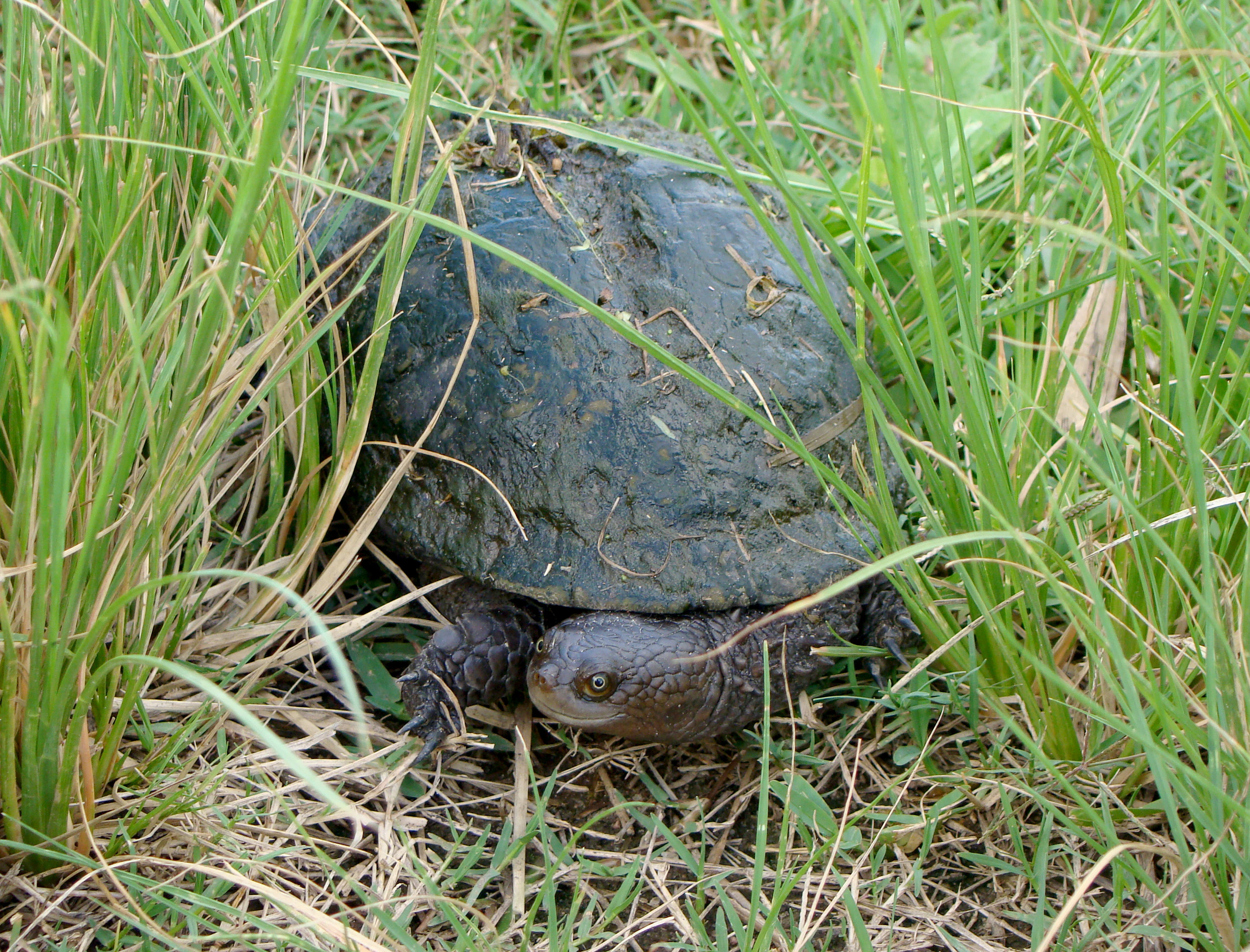
Acanthochelys spixii
Spix's side-necked turtle, also known as the Canaleta turtle

Paisaje protegido Laguna de Castillos history and protected-area timeline

The history of conservation at Laguna de Castillos stretches back more than half a century. In 1966, through Decree No. 266, the Uruguayan government designated the area as a fauna refuge, reflecting early recognition of its importance for native wildlife and native vegetation. That same decree also elevated Cabo Polonio and its dunes to the status of national monument, underlining the broader effort to protect the natural landmarks of Rocha department.

After decades of informal protection and growing ecological awareness, the lagoon and its surrounding woodlands were formally integrated into Uruguay's National System of Protected Areas in 2020. Executive Decree No. 59/020 established the official category of protected landscape for the area, recognizing both its scenic and ecological value. The current designation encompasses the entire lagoon basin and the fringing forest systems, expanding the protective framework beyond the earlier fauna-refuge concept.

This progression from fauna refuge to nationally recognized protected landscape reflects a broader evolution in Uruguayan conservation thinking: away from narrowly defined species protection toward integrated landscape conservation that emphasizes ecosystems, habitat continuity, and ecological function.

Paisaje protegido Laguna de Castillos landscape and geographic character

The physical setting of the Paisaje protegido Laguna de Castillos is shaped by a large coastal lagoon flanked by native woodlands and sandy coastal terrain. The Laguna de Castillos itself is the dominant landscape element, covering around 8,000 hectares and forming a wide sheet of shallow water bordered by marshy edges and forested shorelines.

Stretching for about 20 kilometers along the eastern shore, the ombú forest creates a visually striking stand of large, broad-canopied trees that give the area its distinctive silhouette. The ombúes share this habitat with other native tree species such as coronilla, tala, espinillo, ceibo, and arrayán, producing a varied mosaic of woodland and wetland.

The Valizas Creek (Arroyo Valizas) acts as a hydrological link between the lagoon and the coastal environment beyond, influencing sediment patterns and water levels while shaping access routes into the reserve. The interplay of lagoon, creek, forest, and sandy coastal plain produces a layered coastal landscape unique to eastern Uruguay.
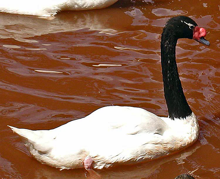
Black-necked swan
A Black-necked swan, Cygnus melanocorypha, in its natural habitat.

Paisaje protegido Laguna de Castillos ecosystems, habitats, and plant life

Ecologically, the protected landscape fuses freshwater, wetland, and dryland forest systems within a relatively compact area. The lagoon waters support submerged and emergent vegetation characteristic of coastal lagoons, while the fringing forest provides nesting cover, food resources, and shelter for waterbirds and terrestrial fauna alike.

The ombú-dominated woodland is a defining ecological feature. Ombúes are accompanied by coronilla, arrayán, ceibo, tala, and espinillo, along with lower-stature plants such as envira, which holds traditional cultural significance. Together these species form a mixed native forest that retains characteristics of Uruguay's pre-agricultural vegetation cover.

Seasonal flooding and lagoon dynamics shape the wetland habitat cycles, supporting amphibian breeding and regulating the availability of aquatic resources for fish and waterbirds. This blend of forest and wetland gives the area a unique ecological signature within Rocha's coastal protected-area network.
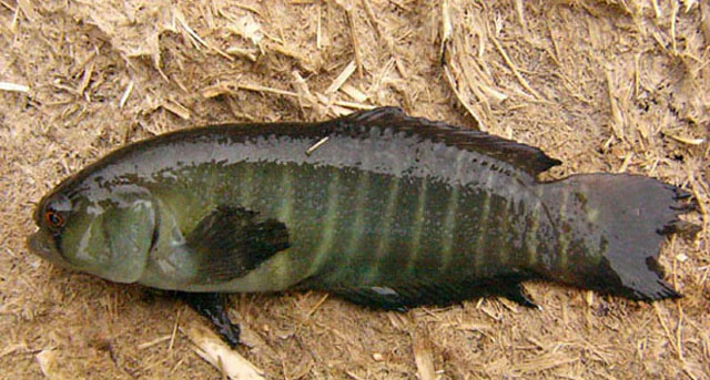
Austrolebias cheradophilus
A species of annual killifish found in the Laguna de Castillos region.

Paisaje protegido Laguna de Castillos wildlife and species highlights

The wildlife profile of Laguna de Castillos is dominated by exceptional avian diversity, with more than 250 recorded bird species. Several of these have global conservation significance, including the dragón (a regionally threatened species) and the viudita blanca. The lagoon is especially important for waterbirds, with seasonal concentrations of black-necked swans and year-round presence of coscoroba swans in flocks of approximately 500 individuals.

Other notable waterbirds include the pato cuchara and pato gargantilla, while the Chilean flamingo has become increasingly common in recent years, adding a striking presence to the lagoon's birdlife. Together, these species reflect the lagoon's role as a key coastal site for migratory and resident bird populations along Uruguay's Atlantic coast.

Beyond birds, the protected landscape supports distinctive freshwater fauna, including the Sapito de Darwin, three species of annual fish of the Austrolebias genus, and a population of the dark-backed apereá, a cavy species endemic to a small number of localities in southern Brazil and Uruguay. The canaleta turtle is also common in the small streams and livestock watering points that feed the lagoon.

Paisaje protegido Laguna de Castillos conservation status and protection priorities

The Paisaje protegido Laguna de Castillos holds substantial conservation significance as one of the few formally protected coastal lagoon systems in Uruguay. Its inclusion in the National System of Protected Areas in 2020 strengthened protections first established in 1966, when the area was recognized as a fauna refuge. The current management focuses on preserving the integrity of the lagoon, its fringing ombú forest, and the supporting wetlands as a connected ecosystem.

The area plays a key role in protecting threatened and endemic species, including rare annual fish, regionally restricted cavies, and waterbird species of global conservation concern. By maintaining habitat continuity between freshwater, wetland, and dryland forest environments, the protected landscape contributes to ecosystem resilience in a region otherwise affected by agricultural development and coastal change.

Ongoing ranger presence and conservation outreach reinforce the protected status of the site, with the area also serving as a focal point for environmental awareness within the Rocha department. Its formal recognition as a pais protegido underscores its value not only as wildlife habitat but also as part of Uruguay's broader natural heritage.

Paisaje protegido Laguna de Castillos cultural meaning and human context

The ombú forest at Laguna de Castillos holds cultural as well as ecological resonance. Local tradition notes that the ombúes were introduced from Paraguay and Misiones, while native plants like envira carry indigenous knowledge, having historically been used by local communities to make ligatures in emergencies such as venomous snakebites. These threads of indigenous and rural land-use history are quietly embedded in the landscape.

The site also has a notable place in Uruguayan conservation history, associated with Juan Carlos Gambarotta, recognized as the country's first park ranger. His legacy connects the lagoon to the broader development of professional conservation work in Uruguay, giving the site a foundational role in the country's environmental heritage.

Top sights and standout views in Paisaje protegido Laguna de Castillos

One of the standout features of the Paisaje protegido Laguna de Castillos is its 20-kilometer ombú forest, the largest continuous grouping of ombú trees in Uruguay. Combined with the 8,000-hectare coastal lagoon, the area offers an unusually complete example of how forest, wetland, and open water can coexist in a single protected landscape.

Equally distinctive is the area's birdlife diversity, with more than 250 recorded species and seasonal gatherings of black-necked and coscoroba swans. The presence of rare annual fish, endemic cavies, and the increasing occurrence of Chilean flamingos further elevate the site's ecological profile, while its dual conservation history as both a 1966 fauna refuge and a 2020 protected landscape marks it as a milestone in Uruguayan conservation policy.

Best time to visit Paisaje protegido Laguna de Castillos

Seasonal timing strongly shapes the experience of the protected landscape. Summer brings the highest concentrations of black-necked swans, transforming the lagoon's open water into a dense gathering of waterfowl, and increases the chances of observing wide-ranging bird activity. Warmer months also tend to provide the most comfortable conditions for exploring the ombú forest and the surrounding coastal terrain.

In cooler seasons, the lagoon continues to support year-round populations of coscoroba swans and a wide variety of resident and migratory birds, though some waterbird concentrations may diminish. The shifting dynamics between wet and dry periods also influence the lagoon's water levels and accessibility, making timing an important factor for visitors interested in observing specific wildlife or landscape conditions.
Monthly climate preview

Long-term temperature ranges and monthly precipitation averages across the coordinate sample

Climate Normals and Annual Weather Patterns for Paisaje protegido Laguna de Castillos

Representative baseline coordinates for Paisaje protegido Laguna de Castillos record mean monthly temperatures spanning from eleven to twenty-two degrees Celsius alongside steady daily precipitation rates. Examining the full twelve-month profile reveals complete variations in thermal ranges and long-term climate normals across the protected area.
Annual mean17 °C
11 °C22 °C
Jan22°
Feb22°
Mar21°
Apr19°
May16°
Jun13°
Jul11°
Aug12°
Sep13°
Oct15°
Nov18°
Dec20°
Warmest month
February

22.1 °C

Coolest month
July

11.1 °C

Wettest month
April

4.5 mm/day

Driest month
December

3 mm/day

Park location guide

Geography guide, regional context, and park location map for Paisaje protegido Laguna de Castillos

Paisaje protegido Laguna de Castillos park geography, regions, and map view in Uruguay

Understand where Paisaje protegido Laguna de Castillos sits in Uruguay through a broader geographic reading of the surrounding landscape, nearby location context, and its mapped position within the national park landscape.

How Paisaje protegido Laguna de Castillos fits into Uruguay

Uruguay is a unitary presidential republic located in southeastern South America. It covers approximately 176,215 km² and has a population of nearly 3.5 million people. The capital and largest city is Montevideo, where roughly 2 million people live in the metropolitan area. Uruguay gained independence between 1825 and 1828 following territorial disputes involving Portugal, Spain, Brazil, and the United Provinces of the Río de la Plata.

Wider geography shaping Paisaje protegido Laguna de Castillos in Uruguay

Uruguay is situated in the southeastern part of South America, bordering Argentina to its west and southwest, Brazil to its north and northeast, the Río de la Plata estuary to the south, and the Atlantic Ocean to the southeast. The terrain consists primarily of rolling plains and low hills, with the highest point being Cerro Catedral at approximately 514 meters. The country has several rivers including the Uruguay River, Paraná River, and Negro River.

Map view of Paisaje protegido Laguna de Castillos

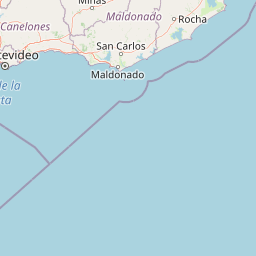
Use this park location map to pinpoint Paisaje protegido Laguna de Castillos in Uruguay, understand its exact geographic position, and read its mapped placement within the surrounding landscape more clearly.

Pigeon | © OpenStreetMap contributors

Location context for Paisaje protegido Laguna de Castillos

Rocha

Visualizing coastal lagoons, ombú forests, and protected wetland habitats

Paisaje Protegido Laguna de Castillos Photos and Landscape Scenery

Photographic collections reveal the distinctive terrain and native woodlands defining Paisaje protegido Laguna de Castillos. Visual research into coastal wetlands and forest canopies clarifies the ecological character of this protected landscape.

Acanthochelys spixii

Chilean Flamingo

Black-necked swan

Austrolebias cheradophilus

Park atlas

Compare surrounding coastal landscapes and neighboring protected zones in eastern Uruguay.

Parks Near Paisaje Protegido Laguna De Castillos And Regional Protected Areas

Explore other parks and protected areas near Paisaje Protegido Laguna De Castillos to examine regional wetland geography and coastal woodland habitats. Broader park comparison reveals ecological patterns across the surrounding Rocha department and wider coastal terrain.
National parkRocha
About 7.2 km away#1 closest

Southeast

Parque nacional Cabo Polonio: Coastal Geography and Marine Protected Area Atlas

Examining dune systems, coastal lagoons, and marine habitats

Analyze the geography of Parque nacional Cabo Polonio, a protected area in Uruguay's Rocha region. This atlas entry details the mosaic of transverse dunes, interdunal wetlands, rocky outcrops, and oceanic islands that define this significant coastal-marine protected landscape.

Area
258.2 km²
Established
2009
Relief
Lowland
Climate
Subtropical
Protected landscapeRocha Department
About 41 km away#2 closest

Southwest

Laguna de Rocha Protected Landscape: Mapping Coastal Uruguay and its Dynamic Wetland Geography

Explore the unique barrier lagoon system and diverse coastal habitats of Rocha Department.

Laguna de Rocha functions as a vital coastal lagoon and wetland complex in southeastern Uruguay. Characterized by its shallow water and temporary sandbar breaches, the area supports a distinct mosaic of habitats, including dunes, reedbeds, and mudflats. Its status as a biosphere reserve and Important Bird Area underscores the ecological importance of this regional geography in providing a sanctuary for migratory waterbirds along the Atlantic coast.

Area
220 km²
Established
2010
Relief
Lowland
Climate
Temperate
National parkRocha Department
About 45 km away#3 closest

Northeast

Santa Teresa National Park: Mapped Coastal Forest and Beach Protected Landscape

Explore Rocha Department's unique protected Atlantic coast geography.

Santa Teresa National Park, a designated national park in Uruguay's Rocha Department, offers a compelling example of a protected coastal environment. Its landscape is characterized by a distinctive blend of dense forests that reach down to the sandy shores of the Atlantic Ocean, a rare feature in the region's protected areas. This page provides detailed geographic context and map-based exploration for understanding this unique seaside national park and its place within Uruguay's conservation atlas.

IUCN
II
Relief
Lowland
Climate
Subtropical
Access
Easy access
National parkRocha Department
About 49 km away#4 closest

Northeast

Parque Nacional Laguna Negra: Geographic Map and Protected Area Overview

Wetland and Savanna Landscapes in Rocha Department

Parque Nacional Laguna Negra protects a compressed mosaic of coastal environments in eastern Uruguay. The area integrates dense marshlands with native grasslands and patches of indigenous forest, providing a essential habitat corridor along the Atlantic coast. Use this atlas resource to understand its terrain and internal environmental distribution.

Area
7.15 km²
Established
2025
Relief
Lowland
Climate
Temperate
Wildlife reserveDepartamento de Rocha
About 57 km away#5 closest

Northeast

Área de manejo de hábitats y/o especies Cerro Verde e Islas de la Coronilla Protected Landscape

Coastal and marine wildlife reserve in Departamento de Rocha

Spanning both land and sea, this reserve protects a rare combination of granite coastal hills, relict forests, and oceanic islands along the Uruguayan Atlantic. Learn about its integrated role within the Banos del Este biosphere and its importance as a habitat for endangered green sea turtles and migrating southern right whales.

Area
16.88 km²
Established
2011
Relief
Lowland
Climate
Temperate
National parkDepartamento de Rocha
About 73 km away#6 closest

Northeast

Parque nacional San Miguel: Mapped Protected Landscapes of Departamento de Rocha

Volcanic hills, native woodlands, and seasonal wetlands

Parque nacional San Miguel serves as a vital protected area, showcasing the distinctive topography of the Sierra de San Miguel. The terrain transitions from rocky volcanic slopes to expansive low-lying wetlands, creating a layered environment of native forests and open prairies that define this essential segment of the regional geography in Departamento de Rocha.

Area
15.42 km²
Established
1937
Relief
Upland
Climate
Temperate
Wildlife reserveMaldonado
About 78 km away#7 closest

Southwest

Area de manejo de habitats y/o especies Laguna Garzon: Wildlife Reserve and Coastal Atlas

Mapped wetlands and Atlantic coastal landscapes in Maldonado, Uruguay.

The Area de manejo de habitats y/o especies Laguna Garzon protected area features a unique mosaic of interconnected lagoons and dune-backed shorelines. This coastal wildlife reserve offers a significant geographic study of wetland habitats and their interaction with the Atlantic maritime zone, providing essential context for understanding Uruguay's southeastern coastal terrain.

Established
2014
Water
Water-dominated
Biosphere reserveUruguay
About 95 km away#8 closest

North

Reserva de biosfera Bañados del Este: Geographic Overview of Uruguay Wetlands

Mapping protected lagoons, sierras, and palm savannas

Reserva de biosfera Bañados del Este represents one of South America's most significant wetland systems. This overview highlights the ecological and physical geography of a protected area that stretches from rolling crystalline sierras down to the Atlantic coastal lagoons, examining the interplay of marshlands, grasslands, and forest remnants that shape this vital Uruguayan region.

Area
12,500 km²
Established
1976
IUCN
IV
Relief
Mixed relief

Common questions about visiting, size, designation, and location context for Paisaje protegido Laguna de Castillos

Paisaje protegido Laguna de Castillos FAQs for park facts, access, geography, and protected area context

Find quick answers about Paisaje protegido Laguna de Castillos, including protected-area facts, park geography, trail and visitor context, and how the park fits into its surrounding country and regional landscape.
MoriAtlas Explorer

Continue Your Protected Areas Search Across the Global Atlas

Deepen your exploration by continuing the structured search for national parks and protected areas worldwide. Utilize the comprehensive filtering capabilities to compare different conservation landscapes and refine your understanding of global park geography. Discover more about the distribution and characteristics of protected natural areas.

Global natural geography