

Mori Atlas logo
Wildlife reservePandam Wildlife Park

Tracing the boundaries of wetlands, savanna mosaics, and riverine forest systems within the Bauchi Plateau

Pandam Wildlife Park: A Comprehensive Geographic Profile of a Nigerian Wildlife Reserve

(Pandam and Wase Lakes Wildlife Park)

Pandam Wildlife Park represents a vital protected landscape in central Nigeria, situated along the southern edge of the Bauchi Plateau. This reserve encompasses a dynamic mosaic of Sudan and Guinea savanna, defined by the seasonal hydrology of Pandam Lake and the adjacent Dep River floodplains. Through our mapping of this area, users can examine the interplay between ribbon-like gallery forests and expansive wetland habitats that support regionally significant mammal and avian populations.

wetland reserveRamsar sitesavannaGuinea savannaSudan savannagallery forest

Pandam Wildlife Park

Wildlife reserve

Park overview

Structured park overview, official facts, and landscape profile for Pandam Wildlife Park

Pandam Wildlife Park park facts, protected area profile, and essential visitor context

Review the core facts for Pandam Wildlife Park, including designation, size, terrain, visitor scale, habitats, and operating context in one park-focused overview.

About Pandam Wildlife Park

Pandam Wildlife Park lies in central Nigeria, within Nasarawa and Plateau States, occupying the southern flank of the Bauchi Plateau. The protected area sits in a shallow basin that slopes gently southward, framed by the Dep River and its upper Ankwe tributaries in the north and west, and bordered by the settlements of Pandam, Namu, Kayarda, and Aningo. At around 197 km², it is medium-sized by Nigerian standards but ecologically dense, combining several distinct habitats within a relatively compact landscape.

The defining feature of the park is Pandam Lake, a narrow waterbody roughly 150 meters wide and about three kilometers long, fed by the Kurmi, Dogon, and Zurzurfar streams. In the dry season the lake is essentially endorheic, losing its connection to the river system, while during the rains it expands into the broad floodplains of the Dep River. This seasonal hydrology shapes both the wetland character of the reserve and its importance for waterbirds, fish populations, and aquatic mammals.

Beyond the lake, the park extends across a mosaic of Sudan savanna in the north and Guinea savanna toward the south, interspersed with stands of broadleaved trees and gallery forests along the river valleys. This combination of woodland, savanna, seasonal wetlands, and gallery forest gives Pandam Wildlife Park its strong habitat diversity and underlies its value as both a Ramsar wetland and a savanna wildlife refuge.

Quick facts and research context for Pandam Wildlife Park

Pandam Wildlife Park is a Nigerian wildlife reserve of about 197 km² located on the southern Bauchi Plateau, spanning Nasarawa and Plateau States. Originally gazetted in 1972 as the Dep River Forest Reserve, it was renamed and internationally recognized when, in 2008, it was added to the Ramsar list of wetlands of international importance as the Pandam and Wase Lakes Wildlife Park.

Its terrain is a southward-sloping basin between roughly 175 and 310 meters in elevation, shaped by the Dep River (the upper course of the Ankwe) and centered on the seasonally flooded Pandam Lake. The area combines Sudan and Guinea savanna with gallery forests along watercourses, supporting both resident African wildlife and Palearctic wintering birds.

Protection and recognition

Review documented terrestrial protection scope and established designation records for Pandam Wildlife Park

Pandam Wildlife Park Protection Status and Designated Conservation History

Pandam Wildlife Park maintains a terrestrial protection scope established through official designation records dating from 2008. Structured conservation metrics outline the recorded management framework and recognized administrative status for this protected area.

Protection details

Protection scope
Terrestrial
Designated year
2008
Transboundary protection
No
Park context

Deeper park guide and search-rich context for Pandam Wildlife Park

Pandam Wildlife Park history, landscape, wildlife, and travel context

Explore Pandam Wildlife Park through its history, landscape character, ecosystems, wildlife, conservation priorities, cultural context, and seasonal travel timing in a structured park guide built for atlas discovery and search intent.

Why Pandam Wildlife Park stands out

Pandam Wildlife Park is best known for its central wetland system centered on Pandam Lake, a seasonal lake connected to the Dep River only during the rainy season, and for its international recognition as a Ramsar site of outstanding ecological value. The park protects a mosaic of Sudan and Guinea savanna, gallery forests, and seasonal floodplains, and is notable for combining savanna mammals such as roan antelope and African buffalo with aquatic species including hippopotamus, Nile crocodile, and the African manatee. The reserve is also recognized for its unusually rich birdlife, with more than 200 recorded species, many of which are Palearctic migrants that use the park as a wintering area. Together, these qualities make it one of Nigeria's flagship wetland-biodiversity protected areas.
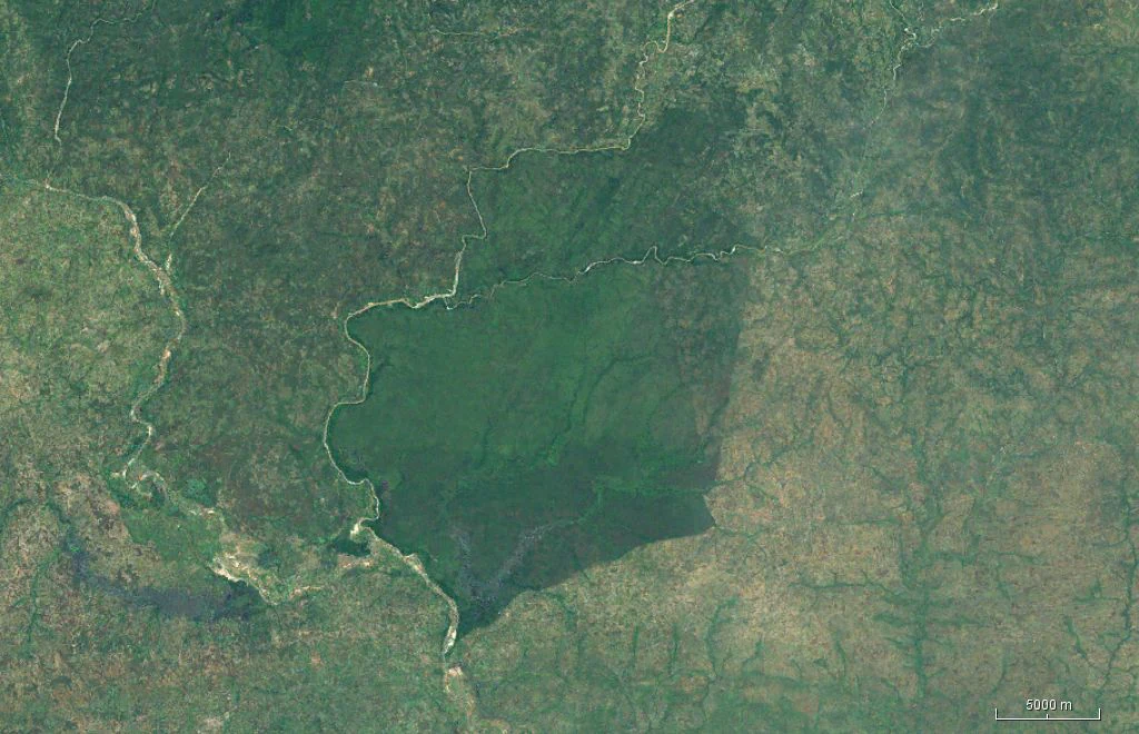
Satellite imagery showing a large, densely forested area in Pandam Wildlife Park bordered by a winding river.
Satellite view of the Pandam Wildlife Park area featuring the dense forest bordering the river system.

Pandam Wildlife Park history and protected-area timeline

The protected area now known as Pandam Wildlife Park was first established in 1972 under the name Dep River Forest Reserve, initially focused on managing the forests along the upper Dep River system. Over subsequent decades, the reserve's significance shifted as its wetland values, particularly those of Pandam Lake and its associated floodplains, became more widely recognized.

On 30 April 2008, the area was formally inscribed on the Ramsar list of wetlands of international importance under the title Pandam and Wase Lakes Wildlife Park, marking a major step in the area's conservation status. The park is administered by the Ministry of Land and Forestry of Nasarawa State, reflecting its location spanning Nasarawa and Plateau States.

The park has also been promoted as a showcase for gentle, sustainable tourism development in Nigeria, with recorded visitation rising to more than 27,000 visitors in 2004. Its Ramsar designation and its accessibility from regional centers such as Shendam, Wase, and Pan Quan have made it a focal point for discussions about wetland conservation and nature tourism in central Nigeria.

Pandam Wildlife Park landscape and geographic character

The landscape of Pandam Wildlife Park is defined by the southern edge of the Bauchi Plateau. Elevations within the reserve range from roughly 175 to 310 meters above sea level, with the terrain generally sloping southward into a basin. The Dep River, the upper course of the Ankwe, marks the northern and western boundaries, while the southern and eastern edges of the park approach the settlements of Pandam, Namu, Kayarda, and Aningo.

The central feature is the narrow Pandam Lake, about 150 meters across and roughly three kilometers long, fed by the Kurmi, Dogon, and Zurzurfar streams. During the dry season, the lake is effectively closed, cut off from the wider river system. In the rainy season, however, the lake expands, and its waters merge with the extensive floodplain wetlands of the Dep River, creating a much larger wetland complex that defines the park's hydrology and seasonal character.

Surrounding the lake and its tributaries is a savanna landscape that transitions from Sudan savanna in the north to Guinea savanna in the south, with widely spaced trees and patches of denser vegetation along the watercourses. The valleys of the rivers carry ribbon-like gallery forests that contrast with the open savanna matrix, producing a layered landscape of plateau woodland, valley forest, open water, and seasonal floodplain.

Pandam Wildlife Park ecosystems, habitats, and plant life

Ecologically, Pandam Wildlife Park sits at a transition between two major West African savanna systems. The northern portion is characterized by Sudan savanna vegetation adapted to a relatively dry climate, while the southern parts grade into Guinea savanna with taller grasses and a denser tree layer. Woven through this savanna matrix are gallery forests along the rivers and streams, which create narrow corridors of closed-canopy habitat that contrast sharply with the surrounding open woodland.

Botanical surveys have recorded around 152 species of vascular plants across 52 genera and families. Common savanna trees include Isoberlinia doka, Combretum glutinosum, Parkia biglobosa, Butyrospermum paradoxon (the shea tree), Daniellia oliveri, Gardenia aqualla, Dentarium microcarpum, and Burkia africana, while gallery forests harbor species such as Afzelia africana, Ceiba pentandra (the kapok tree), and Raphia sudanica. This mix of dry-adapted savanna trees, fire-maintained grasslands, and moist gallery forest species gives the park its distinctive ecological layering.

The park's climate is tropical with a clear wet-dry seasonal pattern. Annual rainfall ranges from about 1,200 to 1,500 mm, concentrated between April and October, with August and September at the peak of the West African monsoon. The dry season runs from November to March and is dominated by the Harmattan, the dry north-easterly trade wind from the Sahara. Mean daily temperatures range from about 25°C in August to 35°C in March, defining the strong seasonal rhythm of the park's ecological processes.

Pandam Wildlife Park wildlife and species highlights

Pandam Wildlife Park supports a mix of savanna mammals, wetland-associated species, and a notably rich bird community. Among the larger mammals, populations of roan antelope, African buffalo, red river hog, and waterbuck have been recorded. The lake and its tributaries also host hippopotamus, Nile crocodile, and the African manatee, a rare aquatic mammal that is among the species of highest conservation concern in the park.

The park's avifauna is one of its standout features, with around 219 bird species documented. The mix includes many waterbirds that depend on the lake and its floodplains, alongside a notable component of Palearctic migrants that use the area as a wintering ground, taking advantage of the seasonal abundance of water and habitat. This dual resident and migratory character contributes to the park's Ramsar designation and its broader conservation importance.

The aquatic fauna of Pandam Lake and its associated rivers is similarly diverse, with 29 fish species from 18 genera recorded. The fish community includes several tilapia species, African bonytongue, the African high-back characin (Citharinus citharus), Labeo senegalensis, Nile perch, electric catfish, and small populations of the pufferfish Tetraodon lineatus. Together, these mammal, bird, and fish communities reflect the park's unusually broad habitat range and underline its ecological significance.

Pandam Wildlife Park conservation status and protection priorities

Conservation significance lies at the heart of Pandam Wildlife Park's identity. Originally designated in 1972 as the Dep River Forest Reserve, the area was elevated in 2008 with its inscription on the Ramsar list of wetlands of international importance under the name Pandam and Wase Lakes Wildlife Park, recognizing its outstanding wetland values. The Ramsar designation draws attention to the lake, its seasonal floodplains, and the broader hydrological system that drives the park's ecological character.

The park protects a gradient of habitats from Sudan and Guinea savanna woodlands to gallery forests, open water, and seasonal floodplain, which together support vulnerable species including the African manatee and Nile crocodile, alongside savanna ungulates and one of the more diverse bird communities in the region. Its role as a wintering site for Palearctic migratory birds strengthens its importance within the broader network of African wetlands.

The reserve is administered by the Nasarawa State Ministry of Land and Forestry, reflecting the cross-state nature of the protected area across Nasarawa and Plateau States. Conservation planning emphasizes the integration of habitat protection, sustainable use, and the development of low-impact tourism, with the park often cited as an example of how gentle tourism development can be combined with wetland conservation in Nigeria.

Top sights and standout views in Pandam Wildlife Park

Among the standout features of Pandam Wildlife Park are its Ramsar-recognized wetland system centered on Pandam Lake, its unusually rich bird community of more than 220 species, and its combination of savanna and gallery forest habitats on the southern Bauchi Plateau. The seasonal hydrology of the lake, closed in the dry months but linked to the Dep River floodplains during the rains, gives the park a dynamic ecological rhythm not often found elsewhere in Nigerian protected areas.

Equally notable are the park's rare and ecologically distinctive species, including hippopotamus, Nile crocodile, and the African manatee sharing habitat with roan antelope, African buffalo, red river hog, and waterbuck. The combination of an internationally recognized wetland, a diverse savanna ecosystem, and a relatively accessible location in central Nigeria makes Pandam Wildlife Park a flagship site for understanding savanna-wetland conservation in West Africa.

Best time to visit Pandam Wildlife Park

Pandam Wildlife Park has a strongly seasonal character shaped by the West African monsoon and the Harmattan. The rainy season, roughly April through October, is the period when Pandam Lake and the Dep River floodplains reach their full extent, creating the richest conditions for waterbirds, wetland scenery, and aquatic wildlife; August and September sit at the monsoon peak. However, heavy rains can make trails and access routes more difficult at this time.

The dry season, from November to March, is cooler at the height of the Harmattan and offers easier access and clearer visibility, when water and wildlife tend to concentrate around the shrinking lake and remaining pools. This period can be rewarding for savanna mammal viewing and for observing the transition between resident and migratory bird communities. A visit aimed at experiencing the park's full wetland character tends to align with the later rainy season, while a drier-season visit emphasizes savanna landscapes and concentrated wildlife sightings.

Monthly climate preview

Long-term representative records tracking monthly temperature and precipitation variation across the protected landscape

Pandam Wildlife Park Climate Normals, Annual Temperature and Precipitation Rhythm

Historical monitoring data for Pandam Wildlife Park reveals a steady annual cycle of measured temperatures alongside distinct shifts in monthly precipitation averages. Examining the complete twelve-month meteorological profile provides detailed baseline climate normals for comparison across the regional protected area.
Annual mean27 °C
25 °C30 °C
Jan26°
Feb28°
Mar30°
Apr29°
May28°
Jun26°
Jul25°
Aug25°
Sep25°
Oct26°
Nov26°
Dec25°
Warmest month
March

29.8 °C

Coolest month
August

25.1 °C

Wettest month
August

7.1 mm/day

Driest month
December

0 mm/day

Park location guide

Geography guide, regional context, and park location map for Pandam Wildlife Park

Pandam Wildlife Park park geography, regions, and map view in Nigeria

Understand where Pandam Wildlife Park sits in Nigeria through a broader geographic reading of the surrounding landscape, nearby location context, and its mapped position within the national park landscape.

How Pandam Wildlife Park fits into Nigeria

Nigeria is a West African federal republic spanning 923,769 km² between the Sahel and the Gulf of Guinea. It is Africa's most populous nation with over 236 million residents, composed of diverse ethnic groups including Hausa, Yoruba, Igbo, and numerous others. The country operates as a federal presidential republic with 36 states and the Federal Capital Territory, using English as its official language and possessing significant linguistic diversity with over 525 indigenous languages.

Wider geography shaping Pandam Wildlife Park in Nigeria

Nigeria occupies West Africa between the Sahel region to the north and the Gulf of Guinea in the Atlantic Ocean to the south. It shares borders with Niger to the north, Chad to the northeast, Cameroon to the east, and Benin to the west. The country covers an area of 923,769 square kilometres.

Map view of Pandam Wildlife Park

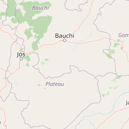
Use this park location map to pinpoint Pandam Wildlife Park in Nigeria, understand its exact geographic position, and read its mapped placement within the surrounding landscape more clearly.

Pigeon | © OpenStreetMap contributors

Location context for Pandam Wildlife Park

NassarawaPlateau

Explore protected area views, seasonal lake habitats, and savanna terrain.

Pandam Wildlife Park Photos and Landscapes: Visualizing Nigerian Wetland Scenery

Protected area photography reveals the mosaic of Sudan savanna, gallery forests, and seasonal floodplains defining Pandam Wildlife Park. Visual reference materials help observers understand the complex wetland ecosystem, river valleys, and diverse natural habitats spanning the Bauchi Plateau.

Satellite imagery showing a large, densely forested area in Pandam Wildlife Park bordered by a winding river.

Park atlas

Compare regional wildlife reserves and connected wetland conservation landscapes

Explore Other Parks Near Pandam Wildlife Park and Surrounding Protected Areas

Browse neighboring protected areas and regional reserves to compare the savanna habitats surrounding Pandam Wildlife Park. Extending the geographic review helps place central Nigerian wetland ecosystems into a broader regional conservation context.
National parkNigeria
About 204 km away#1 closest

Northeast

Yankari National Park: A Protected National Park within Nigeria's Geographic Atlas

Explore the mapped terrain and protected landscape of Yankari National Park.

Yankari National Park, designated as a national park within Nigeria, offers a distinct focus for atlas-driven exploration of protected landscapes. This resource provides a detailed perspective on the park's geographic identity, its mapped boundaries, and its significance within Nigeria's wider network of natural areas. Engage with structured information that highlights the park's place in the regional geography and its value as a mapped natural landscape.

National parkNorth-West Region
About 251 km away#2 closest

Southeast

Kimbi-Fungom National Park: Mapping Protected Forest and Watershed Geography

Essential habitats in Cameroon's North-West Region

Kimbi-Fungom National Park offers a distinct geographic profile, bridging the Bamboutos Mountains with low-lying savanna mosaics and riverine wetlands. This protected landscape is fundamental for the conservation of rare primate communities and the regulation of the Katsina Ala River, which feeds major water infrastructure. Gain insight into the terrain characteristics and ecological boundaries of this significant protected area through detailed mapping and regional context.

Area
657 km²
Established
2015
Relief
Mountain
Climate
Tropical
National parkCameroon
About 264 km away#3 closest

South

Takamanda National Park: Cameroon's National Park Protected Landscape and Geographic Context

Mapped boundaries and regional setting in Cameroon.

Takamanda National Park is a key protected area in Cameroon, offering valuable insights for understanding national park geography and protected landscapes. As a designated national park, it serves as a crucial point of reference for exploring the country's natural regions and their mapped boundaries. Discover the geographic context of Takamanda National Park and its significance within the broader Central African atlas.

Established
2008
Scope
Terrestrial
Water
Minor water
National parkTaraba State
About 286 km away#4 closest

Southeast

Gashaka Gumti National Park: A Deep Dive into Nigeria's Largest Protected Geographic Territory

Mapping the rugged terrain and ecological zones of Taraba State

Spanning over 6,000 square kilometers, Gashaka Gumti National Park is a massive protected expanse that defines the geographic character of northeastern Nigeria. The park integrates diverse environmental zones, including expansive savanna plains and the dramatic slopes of the Chappal Waddi mountain range. This protected area acts as a crucial node for regional biodiversity and remains a central feature in the mapped geography of Taraba State, offering a rare look at Nigeria's vertical landscape transition.

Area
6,402 km²
Established
1991
IUCN
II
Visitors
445 annual
Wildlife reserveNigeria
About 293 km away#5 closest

West

Lower Kaduna-Middle Niger Floodplain: Protected Wildlife Reserve and Wetland Atlas

An expansive floodplain corridor in the heart of Nigeria

Spanning the confluence of the Niger and Kaduna rivers, this wildlife reserve preserves a critical mosaic of swamps, sandbanks, and flooded grasslands. The area is defined by its seasonal inundation cycles and vital role as a refuge for bird populations within the Guinea savanna. Explore the mapped boundaries and natural terrain of this unique aquatic environment.

Area
2,290.54 km²
Established
2008
Relief
Lowland
Climate
Tropical
National parkNigeria
About 318 km away#6 closest

Southeast

Gashaka-Gumti National Park: Geography and Protected Landscape Atlas of Nigeria

Explore mountain peaks, savanna plains, and watershed ecosystems

Gashaka-Gumti National Park serves as a centerpiece of Nigerian conservation, covering an expansive range of topographical features. This protected area connects the West African savanna zone with Central African highland ecosystems, creating a unique environment defined by deep river gorges, high-altitude ridges, and vital forest corridors that define the regional geography.

Area
6,402 km²
Established
1991
Relief
Mixed relief
Climate
Subtropical
National parkCross River State
About 347 km away#7 closest

South

Cross River National Park National Park: Mapped Protected Landscape and Regional Geography

Explore the geographic features and protected area context.

Cross River National Park represents a key protected area within Nigeria, offering valuable insights into its specific landscape and regional geographic setting. This entry focuses on the park's identity as a national park, detailing its mapped boundaries and its role within the broader geography of Cross River State. Users can engage with structured data to understand the park's physical context and its significance as a protected natural landscape, supporting detailed atlas-based exploration.

Area
4,000 km²
Established
1991
IUCN
II
Relief
Mixed relief
National parkNigeria
About 353 km away#8 closest

Northwest

Kamuku National Park: Nigeria's Protected Savanna Ecosystem and Inselberg Landscape

Explore mapped boundaries and regional geography.

Delve into Kamuku National Park, a significant protected savanna ecosystem in Nigeria, recognized for its unique geological features such as the Goron Dutse inselberg and the Dogon Ruwa Waterfalls. This page offers an atlas-level view of the park's landscape, detailing its protected area status, its role as elephant habitat, and its exceptional biodiversity, providing a comprehensive geographic context for exploration.

Area
1,120 km²
Established
1999
IUCN
II
Relief
Lowland

Common questions about visiting, size, designation, and location context for Pandam Wildlife Park

Pandam Wildlife Park FAQs for park facts, access, geography, and protected area context

Find quick answers about Pandam Wildlife Park, including protected-area facts, park geography, trail and visitor context, and how the park fits into its surrounding country and regional landscape.
MoriAtlas Explorer

Continue Your Protected Areas Search Across the Global Atlas

Deepen your exploration by continuing the structured search for national parks and protected areas worldwide. Utilize the comprehensive filtering capabilities to compare different conservation landscapes and refine your understanding of global park geography. Discover more about the distribution and characteristics of protected natural areas.

Global natural geography