Mori Atlas logo
National parkParsa National Park

Discover the mapped landscape and protected area status of Parsa National Park.

Parsa National Park: National Park Boundaries and Geographic Context in Nepal

Parsa National Park stands as a protected landscape within Nepal, offering a distinct geographic entity for atlas-based discovery. This page delves into the mapped boundaries and regional context of this national park, situating it within Nepal's diverse Himalayan terrain. Users can explore the unique protected area characteristics and understand its place in the broader geographic tapestry of South Asia, providing a factual foundation for understanding Nepal's conservation landscapes.

Terai lowland forestBengal tiger habitatSal forest ecosystemProtected areaWildlife conservationSivalik Hills

Parsa National Park

National park

Park overview

Structured park overview, official facts, and landscape profile for Parsa National Park

Parsa National Park park facts, protected area profile, and essential visitor context
Review the core facts for Parsa National Park, including designation, size, terrain, visitor scale, habitats, and operating context in one park-focused overview.

About Parsa National Park

Parsa National Park occupies the Terai lowlands of south-central Nepal, a region historically characterized by dense forests and rich biodiversity before widespread agricultural expansion transformed much of the surrounding landscape. The park's terrain consists of the lower slopes of the Sivalik Hills rising from the alluvial plains, with the East Rapti River forming a natural boundary to human settlements along the northern edge. The park's establishment as a wildlife reserve in 1984 marked a critical step in preserving what remained of the region's forest cover, and its elevation to national park status in 2017 reflected the growing recognition of its conservation importance. The surrounding buffer zone, established in 2005 and expanded in 2015, provides additional protection for wildlife moving between the core protected area and surrounding agricultural lands. The park's strategic position adjacent to Chitwan National Park to the west and Valmiki National Park in India creates a contiguous protected landscape that supports wildlife populations requiring large territories.

Quick facts and research context for Parsa National Park

Parsa National Park covers 627.39 square kilometers in Nepal's Terai region, ranging from 435 to 950 meters elevation in the Sivalik Hills. The park was designated as a wildlife reserve in 1984 and upgraded to national park status in 2017, with a 285.3 square kilometer buffer zone added in 2005 and a further extension of 128 square kilometers in 2015. It forms part of the Tiger Conservation Unit Chitwan-Parsa-Valmiki, a transnational protected area spanning over 3,500 square kilometers. The park features sal forest as its dominant vegetation type, with approximately 919 documented plant species.

Park context

Deeper park guide and search-rich context for Parsa National Park

Parsa National Park history, landscape, wildlife, and travel context
Explore Parsa National Park through its history, landscape character, ecosystems, wildlife, conservation priorities, cultural context, and seasonal travel timing in a structured park guide built for atlas discovery and search intent.

Why Parsa National Park stands out

Parsa National Park is best known for its Bengal tiger population, which has shown significant growth from an estimated 4 individuals in 2008 to 19 tigers documented through camera trapping in 2017. The park also protects substantial populations of gaur, with 37 individuals recorded in a 2008 census, and three Indian rhinoceros. The extensive sal forest ecosystem, covering approximately 90 percent of the park, represents one of the last remaining large blocks of lowland tropical forest in Nepal. The park's location within a transnational tiger conservation corridor linking Nepal and India makes it particularly significant for large carnivore conservation.

Parsa National Park history and protected-area timeline

Before its designation as a protected area, Parsa served as a private game reserve and hunting park frequented by both British colonial administrators and Nepalese elites. This historical use left a legacy of wildlife presence in the region, as the area was maintained as a hunting ground rather than being converted to agriculture. In 1984, the Nepalese government established the area as a wildlife reserve, marking the beginning of formal conservation protection. The reserve remained under this designation for over three decades, during which time baseline wildlife surveys were conducted and management plans were developed. The upgrade to national park status in 2017 represented a formalization of protection standards and reflected the park's growing importance in Nepal's protected area network. The establishment of a buffer zone in 2005 and subsequent extension in 2015 demonstrated the evolving approach to conservation that recognizes the need to engage with communities living adjacent to protected areas.

Parsa National Park landscape and geographic character

The landscape of Parsa National Park is defined by its position at the interface between the Siwalik foothills and the Terai plains. The terrain rises from approximately 435 meters in the lower areas to around 950 meters in the higher elevations of the Churia Hills that form the park's western boundary. The East Rapti River flows along the northern perimeter, creating a natural barrier that separates the protected forest from human settlements and agricultural land. The topography includes forest-covered slopes, narrow valleys, and riparian corridors where khair and sissoo trees grow along watercourses. The southern portions of the park feature more open areas where sabai grass dominates the hillsides. The park's elevation range, while modest by mountain standards, encompasses distinct ecological zones that support different vegetation communities and wildlife habitats.

Parsa National Park ecosystems, habitats, and plant life

The ecological character of Parsa National Park is dominated by sal forest, which covers approximately 90 percent of the protected area and represents one of the most extensive remaining stands of this ecologically important tree species in Nepal. The sal forest ecosystem provides habitat for a wide range of flora and fauna, with approximately 919 plant species documented within the park boundaries, including 298 vascular plant species, 234 dicots, 58 monocots, five pteridophytes, and a single gymnosperm species. In the Churia Hills, chir pine forms a distinct vegetation community on the steeper slopes. Along watercourses and in riparian areas, khair, sissoo, and silk cotton trees create a different habitat structure. The southern-facing slopes support growth of sabai grass, which historically has been harvested for commercial purposes but now occurs within the protected area where it contributes to habitat diversity. This combination of forest types creates a mosaic of habitats that supports the park's diverse wildlife community.

Parsa National Park wildlife and species highlights

Parsa National Park supports a significant population of Bengal tigers that has been the focus of intensive conservation monitoring. A census conducted in 2008 identified four adult tigers resident in the park, while a more comprehensive camera trapping survey in 2017 documented 19 individuals, representing a substantial population increase. The park also supports a population of 37 gaurs recorded during a 2008 census, making it one of the few areas in Nepal where this large bovine species maintains viable numbers. Three Indian rhinoceros have been recorded in the park, representing a small but significant presence of this endangered species. The reptile community is particularly diverse, with species including mugger crocodile, king cobra, monocled cobra, Russell's viper, elongated tortoise, Indian softshell turtle, Indian black turtle, Indian flapshell turtle, Oriental garden lizard, and Oriental rat snake all present within the protected area.

Parsa National Park conservation status and protection priorities

Parsa National Park plays a critical role in regional conservation efforts as part of the Tiger Conservation Unit Chitwan-Parsa-Valmiki, a transnational protected area complex spanning approximately 3,549 square kilometers across Nepal and India. Within this larger landscape, the core protected area of Parsa, Chitwan, and Valmiki covers roughly 2,075 square kilometers and represents one of the most significant remaining tiger habitats in South Asia. The park's designation as an IUCN Category II protected area reflects its primary objective of conserving natural ecosystems while allowing for limited compatible human use. The buffer zone surrounding the core area helps mitigate human-wildlife conflict and provides wildlife with corridors for movement between protected areas. The documented increase in tiger numbers between 2008 and 2017 suggests that conservation measures implemented in the park are yielding positive results, though the species remains under significant pressure throughout its range.

Parsa National Park cultural meaning and human context

The region surrounding Parsa National Park includes communities whose livelihoods are closely tied to the forests and agricultural lands that border the protected area. Before the establishment of the reserve, the area served as a hunting ground for the British colonial administration and Nepalese aristocracy, a use pattern that shaped both the landscape and local knowledge of wildlife. The transition from a private hunting preserve to a protected area with public access represented a significant shift in how the landscape was managed and perceived. Local communities continue to interact with the buffer zone areas, where sustainable resource use practices have been developed to balance conservation objectives with livelihood needs. The park's proximity to Birgunj, one of the major border crossings between Nepal and India, gives the region strategic importance beyond its ecological value.

Top sights and standout views in Parsa National Park

The most notable highlight of Parsa National Park is its growing Bengal tiger population, which represents one of the most successful conservation outcomes in Nepal's protected area network. The expansion from 4 to 19 tigers documented over approximately a decade demonstrates the potential for effective conservation in Terai ecosystems. The park's position within a transnational tiger corridor connecting Nepal and India makes it strategically important for the long-term viability of tiger populations across their range. The extensive sal forest, covering the majority of the protected area, provides a rare example of intact lowland tropical forest in the region. The presence of multiple large mammal species, including gaur and rhinoceros, indicates a relatively healthy ecosystem capable of supporting apex species.

Best time to visit Parsa National Park

The optimal period for visiting Parsa National Park corresponds with the dry season from October through March, when wildlife is more readily observable as animals congregate around remaining water sources. The winter months from November to February offer pleasant temperatures for outdoor activities and wildlife viewing, though early morning temperatures can be cool. The monsoon season from June to September brings heavy rainfall to the Terai region, making some areas difficult to access and reducing wildlife visibility as animals disperse throughout the forested landscape. The park's accessibility from Birgunj and Hetauda makes it achievable as a day trip or short excursion, though overnight stays allow for more comprehensive exploration of the protected area.

Park location guide

Geography guide, regional context, and park location map for Parsa National Park

Parsa National Park park geography, regions, and map view in Nepal
Understand where Parsa National Park sits in Nepal through a broader geographic reading of the surrounding landscape, nearby location context, and its mapped position within the national park landscape.

How Parsa National Park fits into Nepal

Nepal is a federal parliamentary republic in South Asia, landlocked between China and India. It spans the Himalayas and includes eight of the world's ten highest mountains. Kathmandu is the capital and largest city.

Wider geography shaping Parsa National Park in Nepal

Nepal is located in South Asia, landlocked between China to the north and India to the south, east, and west. The country occupies the Himalayan region in the north and extends into the Indo-Gangetic Plain in the south. Terrain includes the Terai lowlands, subalpine hills, and the Himalayas with peaks including Mount Everest.

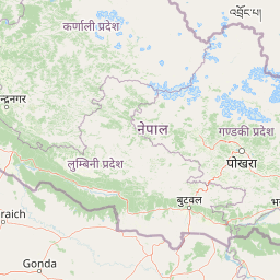
Map view of Parsa National Park

Use this park location map to pinpoint Parsa National Park in Nepal, understand its exact geographic position, and read its mapped placement within the surrounding landscape more clearly.

Pigeon | © OpenStreetMap contributors

Location context for Parsa National Park

Bara DistrictMakwanpur DistrictParsa District
Park atlas

Compare the diverse protected landscapes of Nepal's Terai region, tracing connections to adjacent conservation areas and unique ecosystems.

Explore Related National Parks and Protected Areas Near Parsa National Park, Nepal's Lowland Tiger Habitat
Explore other national parks and protected areas located in the regional vicinity of Parsa National Park, comparing their distinct conservation landscapes and ecological features. This focused view provides essential geographic context for the surrounding Sivalik Hills and Terai plains, allowing for deeper insight into connected ecosystems and regional biodiversity efforts.
National parkNepal

Chitwan National Park: Nepal's Designated National Park Landscape

Explore mapped boundaries and surrounding regional geography.

Chitwan National Park is a vital protected area offering critical insights into Nepal's natural geography. This entry provides detailed information on the park's specific landscape characteristics and its mapped boundaries, crucial for anyone interested in the atlas-level understanding of protected lands within South Asia. Discover the geographic context of this national park and its significance within the broader conservation framework of Nepal.

Area
952.63 km²
Established
1973
IUCN
II
Relief
Mixed relief
National parkWest Champaran District

Valmiki National Park: A Vital National Park and Protected Landscape in Bihar

Explore unique Sivalik terrain and mapped protected area boundaries

Valmiki National Park, located in the West Champaran District of Bihar, is a significant protected area renowned for its unique geography. Situated at the interface of the Himalayas and the Gangetic plains, the park showcases a varied terrain including ridges, gorges, dense forests, and extensive wetlands. As Bihar's only national park and a designated tiger reserve, it offers rich insights into conservation landscapes and regional biodiversity for atlas exploration.

Area
898.45 km²
Established
1990
IUCN
II
Relief
Mixed relief
National parkNepal

Shivapuri Nagarjun National Park: National Park Mapping and Geographic Identity in Nepal

Explore protected boundaries and natural terrain.

Shivapuri Nagarjun National Park serves as a prime example of a protected natural area within Nepal, offering valuable geographic context for atlas exploration. This detail page provides insights into the park's mapped boundaries, its designation as a national park, and its place within the country's diverse natural landscapes. Understanding the terrain and regional distribution of protected areas like Shivapuri Nagarjun National Park is crucial for a comprehensive geographic perspective.

Area
159 km²
Established
2002
IUCN
II
Relief
Mountain
A watercolor painting depicting a river flowing through a valley with mountains in the background and green forests
National parkNepal

Langtang National Park: Nepal's Pioneer Himalayan Protected Landscape and Alpine Atlas

Mapped glaciated terrain, sacred lakes, and towering peaks define this national park.

Langtang National Park, established as Nepal's first Himalayan national park, offers a unique window into high-altitude protected landscapes. Its geography is characterized by dramatic glaciated valleys, soaring mountain peaks including Langtang Lirung, and a rich diversity of alpine ecosystems. This page provides an atlas-centric view of the park's boundaries and its significance within the broader Himalayan conservation context.

Area
1,710 km²
Established
1976
IUCN
II
Relief
Mountain
National parkKoshi Province

Sagarmatha National Park: Mapped Protected Landscape and Geographic Identity in Koshi Province

Explore the protected area's regional geographic context.

Sagarmatha National Park serves as a distinct protected national park entity. This page facilitates an in-depth understanding of its mapped boundaries and its location within Koshi Province. Users can explore the park's specific landscape characteristics and its position within the broader regional geography, providing a foundation for atlas and map-driven discovery.

Area
1,148 km²
Established
1976
IUCN
II
Visitors
19K annual
National parkNepal

Banke National Park: Nepal National Park with Distinct Protected Landscape Geography

Explore the mapped terrain and regional atlas context of Banke National Park.

Banke National Park represents a vital protected area within Nepal's diverse geography, offering a focused point for atlas and map-based discovery. As a national park, its designated status highlights its importance in conserving natural landscapes and understanding regional protected-area distribution across South Asia. This entry provides detailed geographic context, enabling users to explore the park's mapped boundaries and appreciate its role within Nepal's broader natural territory.

Area
550 km²
Established
2010
IUCN
II
Relief
Upland
National parkNepal

Shey Phoksundo National Park: Nepal's Largest Trans-Himalayan Protected Landscape with Phoksundo Lake

Explore alpine terrain and unique protected ecosystems.

Delve into the geographical distinctiveness of Shey Phoksundo National Park, Nepal's expansive protected area. This park is defined by its dramatic elevation changes and the striking Phoksundo Lake, a vivid turquoise alpine reservoir set against barren, mountainous terrain. Understanding its trans-Himalayan setting and protected landscape context reveals its importance within the broader atlas of global natural areas.

Area
3,555 km²
Established
1984
IUCN
II
Relief
Mountain
Watercolor illustration of mountain landscape with green slopes and blue peaks, showing a valley with yellow flowers in the foreground
National parkKoshi Province

Makalu Barun National Park: Protected Landscape and Regional Geography in Koshi Province

Explore the mapped boundaries of this national park.

Makalu Barun National Park is a designated national park providing critical protected landscape data for geographic discovery. Understand its position within Koshi Province and its specific mapped boundaries, offering insights into Nepal's protected areas. This entry is designed for users seeking detailed atlas information on the park's terrain and its role in regional conservation contexts.

Area
1,500 km²
Established
1992
IUCN
II
Relief
Mountain

Common questions about visiting, size, designation, and location context for Parsa National Park

Parsa National Park FAQs for park facts, access, geography, and protected area context
Find quick answers about Parsa National Park, including protected-area facts, park geography, trail and visitor context, and how the park fits into its surrounding country and regional landscape.
MoriAtlas Explorer

Continue Your Protected Areas Search Across the Global Atlas

Deepen your exploration by continuing the structured search for national parks and protected areas worldwide. Utilize the comprehensive filtering capabilities to compare different conservation landscapes and refine your understanding of global park geography. Discover more about the distribution and characteristics of protected natural areas.

Global natural geography