Mori Atlas logo
National parkPaso Bravo National Park

Tracing the boundaries of eastern Paraguay's largest national park within the diverse Concepción terrain.

Paso Bravo National Park: Mapped Protected Landscape and Regional Geography of Northern Paraguay

Paso Bravo National Park encompasses over 1,000 square kilometers of protected wilderness, representing a critical ecological transition zone in northern Paraguay. The area serves as a primary mosaic of cerrado savanna, gallery forests, and seasonal wetlands that anchor the Concepción department landscape. By maintaining connectivity across the eastern Paraguayan river network, this reserve functions as a vital repository for regional biodiversity and a key geographic reference point for South American forest systems.

cerrado savannasubtropical forestriparian corridorswetlandsfreshwater ecosystemslarge cats

Paso Bravo National Park

National park

Park overview

Structured park overview, official facts, and landscape profile for Paso Bravo National Park

Paso Bravo National Park park facts, protected area profile, and essential visitor context

Review the core facts for Paso Bravo National Park, including designation, size, terrain, visitor scale, habitats, and operating context in one park-focused overview.

About Paso Bravo National Park

Paso Bravo National Park occupies a strategic position in the northern part of Paraguay's eastern region, anchoring the country's protected-area system along the busy Concepción-to-Brazil frontier. The park lies within the San Carlos district of Concepción department, a landscape that blends cerrado woodland, humid forest patches, gallery corridors, and seasonal wetlands, creating varied habitat conditions across its roughly 1,030 square kilometers of surface area. Because eastern Paraguay has historically carried the highest rural and agricultural pressure in the country, a protected area of this scale in that region is unusually significant.

The defining feature of Paso Bravo is ecological completeness. Sources indicate that the park hosts around 48 percent of Paraguay's recorded wild fauna, an unusually high concentration for a single reserve. Large terrestrial mammals such as jaguar, puma, maned wolf, and giant anteater coexist with aquatic predators like caimans, anacondas, boa constrictors, and giant otters. Birdlife is particularly rich, with 428 recorded species that include the greater rhea and sixteen parrot species, an indication of the mosaic of open and forested habitats. The park's streams harbor around 103 freshwater fish species, reinforcing its importance for aquatic biodiversity.

Beyond wildlife, Paso Bravo holds notable botanical and cultural importance. Its natural vegetation includes large trees such as the Jataí (Hymenaea courbaril), palo blanco (Calycophyllum multiflorum), yvyra pitá (Peltophorum dubium), and the famous Lapacho (Handroanthus impetiginosus), along with native orchids. The park is also recognized as part of the original range of the cultivated pineapple, cassava, and wild tomato, plants whose ancestral forms were carried northward by Indigenous peoples to Central America and Mexico. As a result, Paso Bravo functions simultaneously as a biodiversity reserve, a forest refuge, and a living element of Paraguay's cultural-natural heritage.

Quick facts and research context for Paso Bravo National Park

Paso Bravo National Park lies in the San Carlos district of Concepción department in northern Paraguay, near the border with Brazil and approximately 590 kilometers from Asunción. Established in 1998, it covers roughly 1,030 square kilometers, making it the largest national park in eastern Paraguay. The protected area encompasses a transition zone between cerrado savanna, semi-deciduous forest, and riparian corridors that drain westward through the Concepción lowlands.

The park has been formally recognized as a stronghold of Paraguayan biodiversity, reportedly harboring around 48 percent of the country's known wild species. Its fauna includes major predators such jaguar and puma, alongside characteristic South American species like the maned wolf, giant anteater, and giant otter, while its streams sustain over one hundred fish species. The climate is tropical and strongly seasonal, with annual rainfall near 1,350 millimeters concentrated between November and December, and cooler winter temperatures between June and August.

Protection and recognition

Terrestrial protected area designation and documented management scope

Paso Bravo National Park Protection Status and Conservation Framework

Paso Bravo National Park maintains a documented terrestrial protection scope within the global conservation framework. Official records compile the designated management parameters and recognition data for structural geographic analysis.

Protection details

Protection scope
Terrestrial
Transboundary protection
No
Park context

Deeper park guide and search-rich context for Paso Bravo National Park

Paso Bravo National Park history, landscape, wildlife, and travel context

Explore Paso Bravo National Park through its history, landscape character, ecosystems, wildlife, conservation priorities, cultural context, and seasonal travel timing in a structured park guide built for atlas discovery and search intent.

Why Paso Bravo National Park stands out

Paso Bravo is best known for being the largest national park in eastern Paraguay and for its remarkably high share of Paraguay's overall biodiversity within a single protected area. Its mosaic of cerrado, forest, and wetland habitats supports an unusually animal-rich assemblage, including both apex predators such as jaguar and puma and more range-restricted species like the maned wolf and giant otter. The park is also distinctive for its botanical and cultural reach. It is considered part of the ancestral range of pineapple, cassava, and wild tomato, crops whose pre-Columbian dispersal from this region is documented across much of the Americas. Combined with its 428 recorded bird species, 103 freshwater fish species, and broad faunal register, Paso Bravo stands out as one of Paraguay's most ecologically complete eastern reserves.
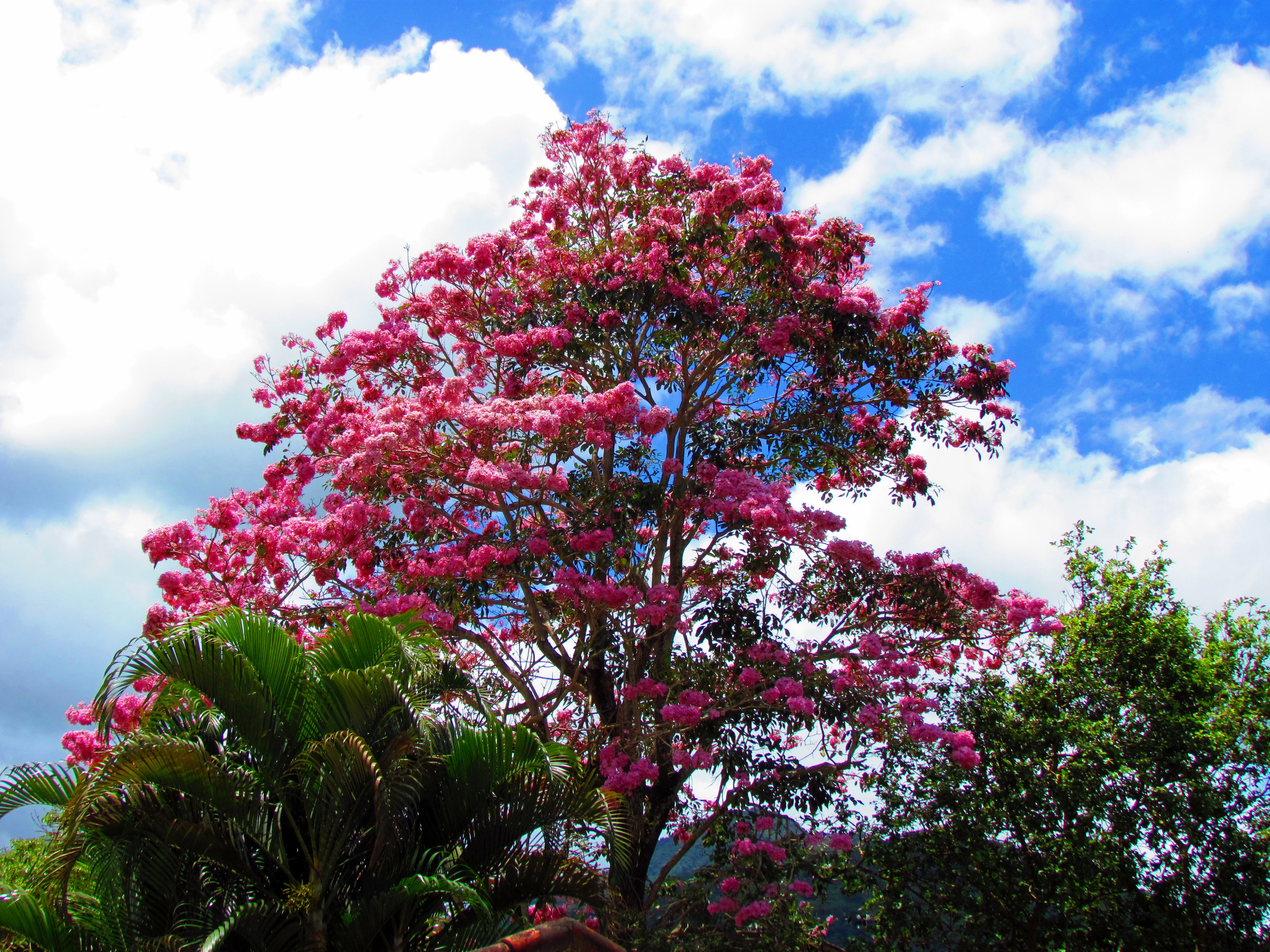
A medium shot of a blooming pink Ipe roxo tree against a bright blue sky with white clouds, with green palm fronds visible in the foreground.
A flowering Ipe roxo tree in bloom, characteristic of the park's native vegetation.

Paso Bravo National Park history and protected-area timeline

Paso Bravo National Park was formally established in 1998, creating the largest national park in eastern Paraguay at the time of its designation. Its creation occurred in a department, Concepción, that had historically experienced both agricultural frontier expansion and proximity to the Brazilian border, making the park a key conservation anchor in the country's increasingly pressured eastern landscapes.

While the surrounding region has long been shaped by human activity, including the Indigenous dispersal of important crops such as pineapple, cassava, and wild tomato from this area, the park itself was carved out as part of Paraguay's modern push to safeguard representative examples of its eastern ecosystems. Its founding reflects the recognition that classic cerrado and forest habitats in this part of South America were being lost to land conversion faster than similar ecosystems in the more sparsely populated Chaco.

Paso Bravo National Park landscape and geographic character

The landscape of Paso Bravo is shaped by the geological transition between the eastern Paraguayan lowlands and the open formations further north. Its roughly 1,030 square kilometers combine cerrado woodland, semi-deciduous forest, riparian gallery corridors, and seasonal wetland basins that mark the broader Concepción terrain. Streams draining the area dissect the terrain into gentle hills and valley systems, while the proximity to Brazil places the park at the edge of the South American forest-savanna transition zone.

The visual character of the park is strongly influenced by vegetation rather than dramatic relief. Park savannas alternate with denser forest stands, while lines of large hardwoods, including lapacho and Jataí, mark watercourses and seasonal lowlands. In the wetter months, November through December, the combination of high rainfall and warm temperatures produces a lush, fully leafed-out landscape; in the cooler, drier months from June through September, the same terrain takes on a more open, sparse appearance.

Paso Bravo National Park ecosystems, habitats, and plant life

Paso Bravo protects a representative slice of the eastern Paraguayan ecosystem mosaic, where cerrado savanna, semi-deciduous forest, gallery forest, and tropical wetlands meet on a single continuous landscape. This habitat diversity is the foundation of the park's rich biodiversity: structural variety in the vegetation directly supports variation in the fauna, from open-country species to canopy-dependent birds and aquatic mammals.

The flora within Paso Bravo includes tall hardwoods such as the Jataí tree (Hymenaea courbaril), palo blanco (Calycophyllum multiflorum), yvyra pitá (Peltophorum dubium), and the showy lapacho (Handroanthus impetiginosus), alongside wild relatives of globally important crops, including pineapple, cassava, and wild tomato. Orchids and other regional flora round out a botanical profile that bridges utilitarian plant heritage and contemporary forest biodiversity.

Paso Bravo National Park wildlife and species highlights

Paso Bravo's wildlife profile is central to the park's identity. Roughly 48 percent of Paraguay's recorded wild fauna is reported to inhabit the park, an exceptionally high share for a single protected area. The mammal register includes major predators such as jaguar and puma, the distinctive maned wolf of the South American savannas, the giant anteater, and the socially complex giant otter. Reptiles are well represented too, with caimans, anacondas, and boa constrictors occupying the aquatic and forest niches.

Birdlife is one of the park's most striking attributes, with 428 recorded bird species that include the conspicuous greater rhea, a ground-dwelling relative of the ostrich, and sixteen parrot species. Below the surface, the streams of Paso Bravo hold around 103 fish species, indicating that even the park's aquatic systems carry notable diversity. The combination of large predators, wide-ranging mammals, abundant reptiles, dense bird populations, and a rich fish fauna positions Paso Bravo among the most animal-rich reserves in Paraguay.

Paso Bravo National Park conservation status and protection priorities

Paso Bravo is a core conservation site within eastern Paraguay, a region where agricultural expansion, ranching, and frontier development place continuous pressure on natural habitats. By protecting around 1,030 square kilometers of cerrado-forest mosaic in Concepción department, the park safeguards both terrestrial habitat and the freshwater systems of multiple streams that flow through it.

The park's conservation value is amplified by the breadth of species it shelters. Sources indicate that roughly 48 percent of Paraguay's wild fauna is found within its boundaries, alongside more than 400 bird species and over 100 freshwater fish species. This concentration gives Paso Bravo an outsized role in maintaining regional biodiversity and ecological connectivity between Paraguay and the Brazilian interior, especially for wide-ranging species that require extensive blocks of natural habitat to persist.

Paso Bravo National Park cultural meaning and human context

Paso Bravo's cultural context is anchored in its identification as a probable origin point for cultivated pineapple, cassava, and the wild tomato. Indigenous communities historically carried these plants from this part of South America northward, eventually reaching Central America and Mexico, where their descendants became staple crops. The park's landscape thus represents not only a natural heritage site but also a cultural-natural landscape tied to the deep agricultural history of the Americas.

In the broader context of Concepción department, the park coexists with long-established patterns of rural land use, ranching, and small-scale agriculture along the Brazilian border. Its protected status provides a counterweight to these pressures and supports the broader identity of northern eastern Paraguay as a transitional region where Indigenous heritage, modern land use, and biodiversity conservation overlap.

Top sights and standout views in Paso Bravo National Park

Paso Bravo stands out as the largest national park in eastern Paraguay, with its 1,030 square kilometers forming a major biodiversity reservoir in a department historically shaped by agricultural expansion. The park's reported coverage of nearly half of Paraguay's known wild fauna, combined with 428 recorded bird species and 103 freshwater fish species, makes it a disproportionately important stronghold of Paraguayan biodiversity.

Its cultural-botanical dimension adds a further layer of distinction: Paso Bravo is recognized as part of the ancestral range of pineapple, cassava, and the wild tomato, crops whose path from this region connected South America to Mesoamerica. Together, its size, species richness, iconic predators, and agricultural heritage give Paso Bravo a unique position among Paraguay's national parks.

Best time to visit Paso Bravo National Park

Paso Bravo's climate is tropical and strongly seasonal, with annual rainfall averaging around 1,350 millimeters. The wetter part of the year, particularly November and December, brings heavy rains that saturate soils and create high, leafy green conditions throughout the park; this can make some trails and low-lying wetlands more difficult to access but is also when the forest is at its most lush and many species are most active.

The drier period, roughly from June to September, sees the lowest rainfall of the year and brings cooler temperatures, with nighttime lows typically around 14 to 15 degrees Celsius between June and August. Daytime highs are most pronounced between November and March, often reaching 33 to 34 degrees Celsius. For visitors drawn to milder temperatures and easier access to open cerrado terrain, the cooler dry months are generally more comfortable, while the wetter months offer a more atmospherically intense, fully leafed tropical experience.

Monthly climate preview

Long-term temperature and precipitation averages recorded at representative park coordinates

Paso Bravo National Park Climate Normals and Monthly Weather Data

Long-term records show average monthly temperatures ranging from 19.34 degrees Celsius to 28.74 degrees Celsius alongside varying daily precipitation levels. Reviewing the complete twelve-month climatology profile provides deeper context on measured annual weather rhythms.
Annual mean25 °C
19 °C29 °C
Jan29°
Feb28°
Mar27°
Apr25°
May21°
Jun20°
Jul19°
Aug22°
Sep25°
Oct27°
Nov27°
Dec28°
Warmest month
January

28.7 °C

Coolest month
July

19.3 °C

Wettest month
November

5.8 mm/day

Driest month
August

1.1 mm/day

Park location guide

Geography guide, regional context, and park location map for Paso Bravo National Park

Paso Bravo National Park park geography, regions, and map view in Paraguay

Understand where Paso Bravo National Park sits in Paraguay through a broader geographic reading of the surrounding landscape, nearby location context, and its mapped position within the national park landscape.

How Paso Bravo National Park fits into Paraguay

Paraguay is a landlocked presidential republic in central South America with a population of approximately 6.4 million. Originally inhabited by the Guaraní people, it was colonized by Spain in the 16th century and gained independence in 1811. The country is notable for its strong Guarani cultural influence, economic growth driven by soybean and beef exports, and significant hydroelectric power generation. Asunción is both the capital and largest city.

Wider geography shaping Paso Bravo National Park in Paraguay

Paraguay is located in the central region of South America, completely landlocked but with Atlantic Ocean access via the Paraná-Paraguay Waterway. It borders Bolivia to the northwest and north, Brazil to the northeast and east, and Argentina to the southeast, south, and west. The terrain consists mostly of rolling plains and lowlands, with the Paraguay River dividing the country into eastern and western regions.

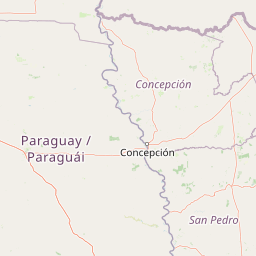
Map view of Paso Bravo National Park

Use this park location map to pinpoint Paso Bravo National Park in Paraguay, understand its exact geographic position, and read its mapped placement within the surrounding landscape more clearly.

Pigeon | © OpenStreetMap contributors

Location context for Paso Bravo National Park

Concepción Department

Visualizing the cerrado savanna, subtropical forest, and wetland habitats of eastern Paraguay.

Paso Bravo National Park Photos and Protected Landscape Scenery

Examine detailed photography showcasing the rolling cerrado woodland, riparian gallery corridors, and diverse habitats of Paso Bravo National Park. These visual records provide clear insight into the protected terrain, native vegetation, and ecological character of northern Paraguay.

A medium shot of a blooming pink Ipe roxo tree against a bright blue sky with white clouds, with green palm fronds visible in the foreground.

Park atlas

Compare regional conservation landscapes and contiguous woodland reserves

Exploring Other Parks Near Paso Bravo National Park and Surrounding Protected Areas

Browse adjacent protected areas and connected savanna ecosystems sharing ecological traits with Paso Bravo National Park. Comparing neighboring habitats provides broader geographic context across the northern frontier transition zone.
National parkParaguay
About 116 km away#1 closest

East

Cerro Corá National Park: Paraguay's Protected Landscape and Regional Geography

Discover the mapped boundaries and natural context of this national park.

Cerro Corá National Park serves as a critical element in Paraguay's protected natural areas. This page offers a deep dive into its identity as a national park, focusing on its geographic location, mapped boundaries, and its place within the broader landscape context of South America. Understand the specific atlas value of this protected land for detailed geographic exploration.

IUCN
II
A soft watercolor illustration of a landscape with green grassy fields in the foreground, calm water in the midground, and gentle rolling hills in the background under a pale, pinkish sky.
Nature reserveCanindeyú Department
About 265 km away#2 closest

Southeast

Mbaracayú Forest Nature Reserve: A Detailed Geographic Atlas of Paraguay's Protected Forest

Mapped terrain, forest corridors, and landscape features

Spanning over 64,000 hectares in the Canindeyú Department, Mbaracayú Forest Nature Reserve preserves the core of the Alto Paraná Atlantic forest. The area features a complex mosaic of subtropical forest, riparian corridors, and the undulating slopes of the Cordillera de Mbaracayú range. This map-focused profile details the reserve's unique topography, stream networks, and its vital role as a continuous wilderness block in eastern Paraguay.

Area
644.05 km²
Established
1991
IUCN
II
Relief
Upland
National parkFormosa Province
About 292 km away#3 closest

South

Río Pilcomayo National Park: Protected Humid Chaco Wetland Landscape & Geography

Explore mapped boundaries and unique floodplain terrain in Formosa Province.

Río Pilcomayo National Park represents a significant protected natural area within Argentina's Formosa Province, characterized by the unique ecosystems of the Humid Chaco. The park's landscape is defined by extensive floodplains, marshes, lakes, and forests, all influenced by the Pilcomayo River's dynamic hydrological cycle. As a Ramsar site, it safeguards crucial habitats, including those for the endangered jaguar, and showcases iconic Caranday palm savannas. This detailed atlas entry provides insights into its mapped geography and the vital protected landscape it preserves.

Area
518.89 km²
Established
1951
IUCN
II
Relief
Lowland
National parkAlto Paraguay
About 312 km away#4 closest

Northwest

Nationalpark Río Negro: Mapping Protected Landscapes in the Alto Paraguay Department

Ecological transition zone between Pantanal, Chaco, and cerrado

Nationalpark Río Negro encompasses a critical mosaic of habitats at the edge of the Bolivian border. This protected area acts as a meeting point for three major South American biomes, resulting in diverse terrain ranging from seasonal wetlands to dry quebracho forests. The park provides an essential geographic anchor for understanding the ecological connectivity of the Paraguayan Pantanal and its unique environmental transitions.

Area
1,238 km²
Established
2004
Relief
Lowland
Climate
Tropical
A soft watercolor illustration depicting a serene landscape with rolling green hills, scattered trees, and a winding stream under a warm, light-colored sky.
Wildlife reserveCanindeyú Department
About 363 km away#5 closest

Southeast

Refugio Carapá Wildlife Reserve: Mapping Biological Diversity in Canindeyú Department

A protected sub-tropical mosaic along the Paraná River basin

Refugio Carapá protects a dramatic stretch of mountain slopes and riverine valleys in the Department of Canindeyú. By managing a mosaic of tall forests, swamps, and open camp vegetation, the reserve maintains a crucial ecological link within the wider Itaipu reservoir landscape. The area functions as a research-focused environment dedicated to preserving native flora and threatened species in eastern Paraguay.

Area
32.5 km²
Established
1984
Relief
Mountain
Climate
Subtropical
National parkSanta Cruz Department
About 376 km away#6 closest

Northwest

Otuquis National Park and Integrated Management Natural Area: Mapped Protected Landscape in Santa Cruz Department

Bolivia's designated national park for atlas exploration.

Gain detailed geographic context for Otuquis National Park and Integrated Management Natural Area, a significant protected landscape within Bolivia's Santa Cruz Department. This page serves as a dedicated entry point for understanding the park's mapped boundaries, its role as a national park, and its natural terrain within the regional atlas. Explore its unique geographic features and its place within Bolivia's network of protected areas.

Area
10,059.5 km²
Established
1997
IUCN
II
Relief
Lowland
National parkParaguay
About 385 km away#7 closest

South

Ypoá National Park: Paraguay's Protected Wetland Landscape and Lake Ecosystem

Explore mapped boundaries and significant bird habitats in the Ñeembucú region.

Ypoá National Park is a critical protected area in Paraguay, renowned for its extensive wetland ecosystems dominated by Lake Ypoá. This national park encompasses a rich mosaic of marshlands, riparian forests, and aquatic vegetation, making it a significant habitat for numerous bird species, including several rare and endemic types. Its designation as a Ramsar Wetland underscores its ecological importance, offering a unique lens for understanding landscape context and protected-area geography within South America.

Area
1,000 km²
Established
1992
IUCN
II
Relief
Lowland
Wildlife reserveAlto Paraná Department
About 423 km away#8 closest

Southeast

Tatí Yupí Refuge: Wildlife Reserve Geography and Paraná River Landscape

A 2,245 hectare protected biological forest in Alto Paraná

Tatí Yupí Refuge offers a unique perspective on protected land management within the Itaipu hydroelectric complex. Explore the mapped boundaries, basaltic stream formations, and subtropical forest habitat that define this essential ecological refuge in Paraguay's Alto Paraná Department.

Area
22.45 km²
Established
1982
Relief
Lowland
Climate
Subtropical

Common questions about visiting, size, designation, and location context for Paso Bravo National Park

Paso Bravo National Park FAQs for park facts, access, geography, and protected area context

Find quick answers about Paso Bravo National Park, including protected-area facts, park geography, trail and visitor context, and how the park fits into its surrounding country and regional landscape.
MoriAtlas Explorer

Continue Your Protected Areas Search Across the Global Atlas

Deepen your exploration by continuing the structured search for national parks and protected areas worldwide. Utilize the comprehensive filtering capabilities to compare different conservation landscapes and refine your understanding of global park geography. Discover more about the distribution and characteristics of protected natural areas.

Global natural geography