Why Peak Charles National Park stands out
Peak Charles National Park is best known for its dramatic granite skyline, where ancient domed peaks rise abruptly from flat, dry sand plain heaths to create one of Western Australia's most striking mountain silhouettes. The twin peaks, particularly Peak Charles with its 651-metre elevation, offer a challenging but rewarding hiking experience via a 2-kilometre loop trail that requires rock scrambling to reach the summit lookout. The park also protects a significant example of the Eastern Mallee bioregion, where salt lake systems intersect with diverse heath communities to support rare and specialised plant species found nowhere else on Earth.
Peak Charles National Park history and protected-area timeline
Peak Charles National Park was established in 1979 as a protected area under the conservation legislation of Western Australia, with management responsibilities delegated to the state's Department of Parks and Wildlife (now part of the Department of Biodiversity, Conservation and Attractions). The creation of the park reflected a growing recognition during the 1970s of the need to protect representative examples of Western Australia's diverse bioregions, particularly those containing unusual geological features or endemic species. Prior to formal protection, the Peak Charles area had been subject to limited pastoral use, though the rugged nature of the granite terrain limited its agricultural potential and helped preserve much of the natural landscape. The park's establishment also acknowledged the landscape's significance to the broader Great Western Woodlands region, which has since become recognised as one of the world's remaining large temperate dryland ecosystems. Management of the park has focused on maintaining its wilderness character, with minimal infrastructure development and no entry fees required for visitors.
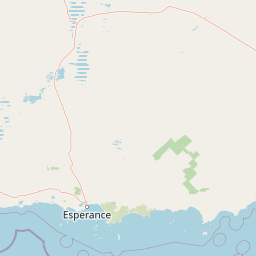
Peak Charles National Park landscape and geographic character
The landscape of Peak Charles National Park is defined by the contrast between its ancient granite peaks and the extensive sand plain that surrounds them. The two principal peaks, Peak Charles and Peak Eleanora, are remnants of Precambrian granite intrusions that formed deep within the Earth's crust over 600 million years ago and have since been exposed through erosion of the overlying rock. These domed inselbergs rise abruptly from the otherwise flat terrain, their rounded summits and steep boulder-strewn slopes creating terrain that is dramatically different from the surrounding plains. The sand plains themselves are composed of deep, sandy soils derived from the weathering of ancient granitic and metamorphic rocks, and support a diverse heathland vegetation community characterised by multiple species of shrubs from the Proteaceae, Myrtaceae, and Epacridaceae families. Between the heaths lie numerous small salt lakes and playas that fill during the winter rains and dry out during the summer months, creating a landscape of subtle but definite ecological zones that respond differently to seasonal rainfall patterns.
Peak Charles National Park ecosystems, habitats, and plant life
The nature of Peak Charles National Park is characterised by the intersection of three distinct ecological systems: the ancient granite outcrops with their specialised plant communities, the extensive sand plain heaths of the Eastern Mallee, and the ephemeral salt lake systems that dot the lower terrain. The heath communities that dominate the park's lower slopes and plains are among the most species-diverse vegetation types in Australian semi-arid environments, with numerous species of shrubs, grasses, and wildflowers adapted to the nutrient-poor soils and long dry seasons. The granite peaks support distinctive plant assemblages that differ from the surrounding heaths, with species adapted to the shallow soils that accumulate in rock crevices and on ledges, as well as those that can tolerate the rapid drainage and increased exposure experienced on exposed rock faces. The park is notable for the presence of Gastrolobium acrocaroli, a rare legume species that exemplifies the high degree of endemism found in the Eastern Mallee bioregion. The salt lake systems, while appearing stark, provide critical habitat for a range of specialised plants and invertebrates adapted to the fluctuating salinity and inundation regimes.
Peak Charles National Park wildlife and species highlights
While the source material provides limited specific information about fauna, the Eastern Mallee bioregion in which Peak Charles National Park is situated supports a range of adapted wildlife species. The heathlands provide habitat for numerous small mammals, reptiles, and invertebrates, while the granite outcrops offer shelter and foraging opportunities for birds and larger reptiles. The salt lakes, when filled with water, attract migratory waterbirds and provide feeding grounds for various shorebird species. The park's isolation and the relative intactness of its vegetation communities suggest that it likely supports populations of native species that have declined in more heavily modified surrounding landscapes. The rocky terrain of the peaks provides nesting and shelter opportunities for raptors and other bird species that utilise the elevated terrain for vantage points and breeding sites.
Peak Charles National Park conservation status and protection priorities
Peak Charles National Park plays an important role in the conservation of the Eastern Mallee bioregion, protecting a landscape that has remained relatively intact compared to much of the surrounding agricultural land in Western Australia's wheatbelt. The park's conservation significance is enhanced by the presence of rare plant species, including Gastrolobium acrocaroli, which is known only from limited populations in the region. The park forms part of the broader Great Western Woodlands conservation network, one of the largest remaining areas of unmodified temperate woodland and heath in the world. Protection of the granite peak system ensures the preservation of unique geological features and the specialised plant communities they support, while the salt lake systems contribute to the conservation of ephemeral wetland habitats that are otherwise scarce in the landscape. The park's management emphasises maintaining natural processes and minimizing visitor impacts to preserve the area's wilderness character.
Peak Charles National Park cultural meaning and human context
Peak Charles National Park is situated within the traditional Country of Aboriginal peoples, though the specific cultural associations and Traditional Owner connections to the peak itself are not extensively documented in the available source material. The broader Great Western Woodlands region contains numerous sites of Aboriginal significance, and the granite peaks with their commanding views would likely have held importance as navigation markers, ceremonial locations, or resource gathering areas for Indigenous peoples. The park's remote location and the challenging nature of the terrain meant that the area was never extensively modified by European settlement, preserving much of its pre-colonial character and allowing the landscape to retain much of its ecological integrity.
Top sights and standout views in Peak Charles National Park
The twin granite peaks of Peak Charles and Peak Eleanora form the park's most spectacular highlight, with their ancient domed shapes creating one of Western Australia's most recognisable mountain silhouettes. The 2-kilometre walking trail to the Peak Charles summit offers visitors the opportunity to experience the park's dramatic geology firsthand while enjoying sweeping views over the heath-covered plains and salt lakes below. The park's wilderness character, maintained through minimal development and the absence of entry fees, provides a back-to-nature experience increasingly rare in protected areas. The diversity of the Eastern Mallee heath communities, particularly during the wildflower season when the heaths erupt in colour, represents another highlight for visitors interested in botanical appreciation. The stark beauty of the salt lake systems, which fill with winter rains and then slowly evaporate through summer, adds another dimension to the park's varied landscape.
Best time to visit Peak Charles National Park
The optimal time to visit Peak Charles National Park is during the cooler months of autumn, winter, and early spring, roughly from April through October, when daytime temperatures are comfortable for hiking and the landscape is at its greenest following winter rainfall. The winter and early spring months typically bring the most vibrant wildflower displays as the heath communities burst into flower, with various species of Proteaceae, Myrtaceae, and other heath species providing colour across the park. Summer months from November to March can bring extreme heat, making hiking hazardous and the landscape brown and dry. Visitors should be aware that the park has limited facilities, so self-sufficiency is essential regardless of when they visit. The Peak Charles summit trail, which requires rock scrambling in places, is best attempted during dry conditions to minimise slip hazards on the granite surfaces.