Mori Atlas logo
Wildlife reservePhou Den Din National Protected Area

Mapped terrain, forest catchments, and ecological connectivity across the Vietnam borderlands.

Phou Den Din National Protected Area: A Remote Highland Wildlife Reserve in Northern Laos

(Phou Den Din National Biodiversity Conservation Area)

Phou Den Din National Protected Area encompasses a vast, rugged expanse of highland forests and deep valleys within Phongsaly Province. This wildlife reserve serves as a critical conservation landscape in northern Laos, characterized by its steep mountain topography and dense, contiguous canopy. The protected area plays a vital role in regional ecological connectivity, sheltering diverse mammal populations and bird habitats that thrive within its remote river catchments and undisturbed forest ecosystems.

Indochinanorthern LaosPhongsaly Provincebiodiversity conservation areaIUCN Category VIhighland forest

Phou Den Din National Protected Area

Wildlife reserve

Park overview

Structured park overview, official facts, and landscape profile for Phou Den Din National Protected Area

Phou Den Din National Protected Area park facts, protected area profile, and essential visitor context

Review the core facts for Phou Den Din National Protected Area, including designation, size, terrain, visitor scale, habitats, and operating context in one park-focused overview.

About Phou Den Din National Protected Area

Phou Den Din National Protected Area is one of northern Laos's quieter but ecologically substantial protected-area designations. Situated in Phongsaly Province, the country's northernmost province, the reserve occupies a stretch of hill and mountain landscape near the border with Vietnam. Its 2,200 square kilometer footprint places it among the more expansive conservation areas in Laos, and its IUCN Category VI designation reflects a management approach that combines biodiversity protection with sustainable use of natural resources.

The landscape is dominated by steep forested ridges, deeply cut river valleys, and elevations that climb above 2,000 meters, producing a mosaic of habitats shaped by altitude, slope, and drainage. These physical conditions support the extensive forest cover for which the area is noted, and they influence the distribution of wildlife across the conservation area. Rivers and streams that drain the reserve ultimately flow eastward toward Vietnam, linking the protected area into broader cross-border ecological systems.

The reserve's ecological identity is anchored by its mammal populations. Elephants, gaurs, bantengs, Asiatic black bears, sun bears, leopards, and tigers all occur within its boundaries, and primates such as gibbons and macaques are reported as part of the resident fauna. Birdlife is also a notable feature, with relatively high densities of lesser fish eagles and crested kingfishers, both of which are tied closely to the area's forested rivers and streams. Together, these species underscore the importance of the area as a refuge for wildlife that depends on large, contiguous blocks of forest habitat.

Access is limited and is typically described as difficult. The conservation area can be reached only by boat or on foot, and there is essentially no conventional tourism infrastructure within or adjacent to it. This inaccessibility has contributed to the relatively undisturbed character of the reserve but also means that the area remains far less studied, visited, or represented in mainstream travel contexts than many of Laos's better-known protected landscapes.

Quick facts and research context for Phou Den Din National Protected Area

Phou Den Din National Protected Area covers roughly 2,200 square kilometers in the northernmost reaches of Laos, within Phongsaly Province and near the international boundary with Vietnam. Designated in 1993 as a National Biodiversity Conservation Area, it is classified under IUCN Category VI, reflecting an emphasis on biodiversity conservation alongside sustainable use of natural resources rather than strict preservation.

The conservation area sits in a region of steep hill and mountain terrain, with elevations rising to over 2,000 meters and supporting extensive forest cover. Its wildlife profile includes several large mammal and bird species of regional and global conservation concern, and its position along the Laos-Vietnam frontier gives it transboundary ecological significance, though its remote setting makes it one of the lesser-visited reserves in the country.

Protection and recognition

Examine the documented 1993 terrestrial designation and management scope for Phou Den Din.

Phou Den Din National Protected Area Protection Status and Designation History

Phou Den Din National Protected Area carries a documented terrestrial protection status established in 1993. Structured designation history details provide clear insight into the official management scope and recorded recognition data.

Protection details

Protection scope
Terrestrial
Designated year
1993
Transboundary protection
No
Park context

Deeper park guide and search-rich context for Phou Den Din National Protected Area

Phou Den Din National Protected Area history, landscape, wildlife, and travel context

Explore Phou Den Din National Protected Area through its history, landscape character, ecosystems, wildlife, conservation priorities, cultural context, and seasonal travel timing in a structured park guide built for atlas discovery and search intent.

Why Phou Den Din National Protected Area stands out

Phou Den Din is best known for its expansive highland forest cover, its populations of large mammals in the remote northern mountains of Laos, and the birdlife supported by its river systems. The reserve is particularly associated with the presence of elephants, gaurs, bantengs, bears, gibbons, and large cats, as well as with species such as the lesser fish eagle and crested kingfisher, which depend on the area's rivers and forested catchments. The combination of borderland geography, dense forest cover, and limited access has shaped the area's character as a quiet, ecologically significant conservation landscape, valued more for its intact habitats and wildlife than for visitor infrastructure.

Phou Den Din National Protected Area history and protected-area timeline

Phou Den Din was officially designated as a National Biodiversity Conservation Area, or NBCA, in 1993, as part of Laos's broader effort to establish a national network of conservation areas during the early 1990s. This designation placed the area within the institutional framework of the country's biodiversity protection system and identified its hill and mountain forests as a landscape of conservation significance, particularly for the wildlife populations they supported.

Beyond the year of its formal gazetting, the historical record for Phou Den Din is relatively limited in publicly available sources. The area has not developed into a major tourism destination, and its remote setting has meant that comprehensive published histories of management, community engagement, and ecological research remain sparse. Its ongoing role continues to be defined by the 1993 designation, its IUCN Category VI classification, and the conservation importance of the habitats and species it protects.

Phou Den Din National Protected Area landscape and geographic character

The landscape of Phou Den Din is shaped entirely by the mountain systems of northern Laos, where deeply weathered ridges and forested valleys rise in a continuous pattern away from the country's lowland reaches. The terrain is steep and hilly throughout, with elevations that climb above 2,000 meters and produce a varied topography of slopes, ridge lines, and sheltered valleys. River systems draining the area cut down through this terrain, creating the corridors that structure much of the local ecology.

Where elevations are highest, cooler conditions and steeper slopes combine to support montane forest character. Lower in the catchments, rivers widen and the surrounding slopes become more gentle, producing vegetation patterns that shift with altitude and aspect. This altitudinal gradient gives the conservation area an unusually broad range of forest habitats within a relatively compact geographic footprint.

The reserves border with Vietnam is also a defining element of its landscape setting. Forest cover, river systems, and wildlife habitat extend across the international boundary into adjacent Vietnamese landscapes, giving Phou Den Din a transboundary character even though it is managed as a national conservation area. The absence of major roads and the limited infrastructure across most of the area reinforce the sense of a continuous, largely undisturbed forest landscape.

Phou Den Din National Protected Area ecosystems, habitats, and plant life

Phou Den Din is fundamentally a forested conservation landscape, with the great majority of its area covered by closed-canopy forest that extends across hill and mountain terrain. Although the precise vegetation classification of the area receives limited public documentation, the altitudinal range and climatic conditions of northern Laos point to a mosaic of lower and upper hill forest, with montane forest types at the higher elevations.

The rivers and streams that drain the reserve are an especially important ecological feature. They not only shape the physical landscape but also create the habitat structure on which several of the area's notable wildlife species depend. Riparian corridors along these waterways support distinctive birdlife and provide movement routes for larger mammals, while the forest cover across the broader catchment maintains moisture regimes, soil stability, and habitat connectivity across the protected area.

Because the area is classified as IUCN Category VI, the natural values of the reserve are expected to be maintained alongside regulated, sustainable uses of its resources. In practice, the limited access and forest cover have left most of the area in a relatively unmodified state, and its ecological identity is that of a working conservation landscape where natural systems remain dominant.

Phou Den Din National Protected Area wildlife and species highlights

The wildlife profile of Phou Den Din is one of its strongest identity features. Large mammals figure prominently, with elephants, gaurs, and bantengs representing some of the most significant ungulate and megaherbivore populations in northern Laos. The presence of these species, alongside Asiatic black bears and sun bears, indicates that the reserve continues to support a community of mammals that has been lost across much of the broader Southeast Asian landscape.

Predators are also part of the resident fauna, with both leopards and tigers reported within the area. Their continued presence suggests that prey populations and forest cover remain sufficient to support large carnivores, an increasingly uncommon condition in the region. Primates are represented by gibbons and macaques, both groups that depend on intact forest canopies and the continuity of habitat across substantial areas.

Birdlife is a particular highlight of the reserve. The area is described as having a high density of lesser fish eagles and crested kingfishers, two species closely tied to forested river systems. Their presence reflects the importance of the area's river catchments as habitat and suggests that the reserve plays a meaningful role in maintaining populations of riparian-dependent bird species in northern Laos.

Phou Den Din National Protected Area conservation status and protection priorities

Phou Den Din's principal conservation role lies in the protection of a substantial block of montane and hill forest in one of the least developed parts of northern Laos. By safeguarding forest cover, river catchments, and the wildlife populations they support, the reserve contributes to the broader resilience of the regional landscape, particularly along the Laos-Vietnam border where habitat continuity is critical for wide-ranging species.

The IUCN Category VI classification under which the area operates reflects a conservation model that emphasizes biodiversity protection alongside regulated use of natural resources. In a region where pressures from logging, hunting, agricultural expansion, and infrastructure development are widespread, the area's remote setting and limited accessibility have provided an important buffer against these threats, although they also complicate active management, monitoring, and research.

The presence of tigers, leopards, elephants, gaurs, and bantengs gives the reserve particular significance for regional conservation priorities, as these species require large, well-connected forest landscapes. Maintaining viable populations of these animals is one of the strongest arguments for the protected area's continuing existence, and underscores its role within Laos's national conservation network.

Phou Den Din National Protected Area cultural meaning and human context

The cultural context of Phou Den Din is closely tied to the geography of Phongsaly Province, which is one of the most ethnically diverse regions of Laos and home to a number of highland communities whose traditional livelihoods are closely linked to forest and river environments. The forested mountain landscape of the reserve has historically supported a mix of subsistence activities, including shifting cultivation, hunting, and the gathering of forest products. These relationships between local communities and the forest landscape form an important, though often underrepresented, dimension of the area's human context.

Because the reserve is remote and has limited public documentation, detailed cultural histories for the area are sparse in widely available sources. The cultural significance of the region is therefore best understood in broader terms, as a highland landscape of northern Laos where ethnic minority communities have long interacted with the forested terrain that the conservation area now seeks to protect.

Top sights and standout views in Phou Den Din National Protected Area

The standout qualities of Phou Den Din lie in the combination of large, contiguous forest habitat, high-elevation terrain, and a wildlife profile that includes several species of regional and global conservation concern. Elephants, gaurs, bantengs, tigers, leopards, and bears together define the area as a landscape of significant ecological value, while species such as the lesser fish eagle and crested kingfisher give it a distinctive birdlife reputation tied directly to its rivers.

Equally important is the reserve's transboundary character. Sharing a border with Vietnam and forming part of a wider block of forested mountain terrain, Phou Den Din functions as a national anchor within a larger regional forest complex, even as its remote setting keeps it firmly outside the conventional visitor circuit.

Best time to visit Phou Den Din National Protected Area

Publicly available guidance on the optimal timing for visiting Phou Den Din is limited, in part because the area is rarely visited and lacks conventional tourism infrastructure. As a forested highland landscape in northern Laos, the area follows the regional monsoon climate, with a wet season that brings heavy rainfall and rough conditions on local rivers and trails, and a drier season during which travel by boat or on foot becomes more practical.

For travelers with the means and experience to access the reserve, the cooler and drier months typically offer better conditions for movement through the forest landscape and for observation of forest wildlife at water sources and along trails. Ultimately, the area is best approached as an expedition-style destination rather than a conventional timed visit, and seasonal conditions should be weighed carefully against the limited infrastructure available.

Monthly climate preview

Long-term temperature ranges and monthly precipitation averages at a representative coordinate

Phou Den Din National Protected Area Climate Normals and Annual Weather Patterns

Historical climate records for Phou Den Din National Protected Area track measured shifts in average monthly temperature and daily precipitation from 1991 to 2020. Reviewing the complete twelve-month meteorological profile reveals the full annual rhythm captured across the protected landscape.
Annual mean20 °C
14 °C24 °C
Jan14°
Feb16°
Mar20°
Apr23°
May24°
Jun24°
Jul24°
Aug23°
Sep22°
Oct20°
Nov17°
Dec14°
Warmest month
June

24.3 °C

Coolest month
December

13.9 °C

Wettest month
July

10 mm/day

Driest month
February

0.7 mm/day

Park location guide

Geography guide, regional context, and park location map for Phou Den Din National Protected Area

Phou Den Din National Protected Area park geography, regions, and map view in Laos

Understand where Phou Den Din National Protected Area sits in Laos through a broader geographic reading of the surrounding landscape, nearby location context, and its mapped position within the national park landscape.

How Phou Den Din National Protected Area fits into Laos

Laos, officially the Lao People's Democratic Republic, is a unitary communist state in mainland Southeast Asia. As the only landlocked country in the region, it shares borders with Myanmar, China, Vietnam, Cambodia, and Thailand. The country has a population of over 7 million and is known for its mountainous terrain, Buddhist heritage, and three UNESCO World Heritage Sites: Luang Prabang, Vat Phou, and the Plain of Jars. The Boten, Vientiane railway completed in 2021 connects Laos to China.

Wider geography shaping Phou Den Din National Protected Area in Laos

Laos is located in mainland Southeast Asia, occupying a mountainous and forested landscape. It is bordered by Myanmar and China to the northwest, Vietnam to the east, Cambodia to the southeast, and Thailand to the west and southwest. As the only landlocked country in Southeast Asia, it has no coastline. The country lies at approximately 17.967°N latitude and 102.6°E longitude.

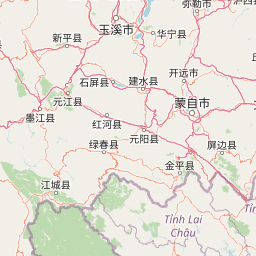
Map view of Phou Den Din National Protected Area

Use this park location map to pinpoint Phou Den Din National Protected Area in Laos, understand its exact geographic position, and read its mapped placement within the surrounding landscape more clearly.

Pigeon | © OpenStreetMap contributors

Location context for Phou Den Din National Protected Area

Phongsaly Province
Park atlas

Compare adjacent highland reserves and connected mountain ecosystems across northern Laos.

Explore Other Parks Near Phou Den Din National Protected Area and Surrounding Landscapes

Continue browsing nearby protected areas that share the rugged mountain terrain and dense forest cover of Phou Den Din National Protected Area. Examining these adjacent reserves reveals broader regional conservation patterns and connected wildlife habitats across the borderlands.
National parkLào Cai Province
About 116 km away#1 closest

East

Hoàng Liên National Park: Vietnam's Highest Mountain and Botanical Treasure in Lào Cai Province

Discover exceptional mountain terrain and unique endemic species habitat.

Hoàng Liên National Park stands as a critical protected landscape in Lào Cai Province, Vietnam, centered around the iconic Fansipan mountain, the highest point in the Indochinese Peninsula. This national park is renowned as a globally important center for plant diversity, showcasing varied mountain terrain from lush evergreen forests to subalpine ecosystems. Explore the mapped boundaries and geographic context of this significant highland protected area, a key destination for understanding Southeast Asian botanical richness.

Area
685.69 km²
Established
2002
IUCN
II
Relief
Mountain
National parkPhú Thọ Province
About 266 km away#2 closest

East

Xuân Sơn National Park: Protected Mountain Landscape and Regional Geography

Mapping the southeastern edge of the Hoang Lien Mountains.

Delve into the protected landscape of Xuân Sơn National Park, a key national park situated in Phú Thọ Province, Vietnam. This area, covering about 150 square kilometers, is defined by its rugged mountainous terrain, featuring steep forested slopes and distinct ridgelines that contribute to the region's varied topography. As a protected national park, Xuân Sơn plays a crucial role in preserving the natural characteristics of the southeastern Hoang Lien Mountains. Its geographic setting is significant, acting as a transition zone between higher montane environments and the nearby lowland river systems, offering a unique perspective on Vietnam's diverse natural heritage.

Area
150.48 km²
Established
1986
IUCN
II
Relief
Mountain
National parkVĩnh Phúc Province
About 313 km away#3 closest

East

Tam Dao National Park: Vietnam's Mountain National Park and Biodiversity Hotspot

Explore mapped boundaries and regional landscape context.

Tam Dao National Park is a key protected area in northern Vietnam, defined by its rugged mountain terrain featuring over 20 peaks exceeding 1,000 meters. This national park is a vital habitat for diverse flora and fauna, including numerous endemic species, and showcases transitional forest ecosystems from tropical to montane zones. Understanding Tam Dao National Park involves exploring its geographic setting within Vĩnh Phúc Province and appreciating its role as a significant protected landscape.

Area
368.83 km²
Established
1996
IUCN
II
Relief
Mountain
National parkHanoi
About 319 km away#4 closest

East

Ba Vì National Park: Ancient Volcanic Mountains and Protected Landscape Near Hanoi

Discover the mapped geography and biodiversity of this national park.

Ba Vì National Park, a protected natural area near Hanoi, showcases a dramatic landscape shaped by ancient volcanic activity. The park features three significant peaks, including Vua Mountain, creating a distinct topographical profile. Spanning over 10,800 hectares, it is recognized for its ecological diversity, harboring a wealth of plant and animal species. This national park serves as a vital protected landscape, offering a unique opportunity for geographic exploration and understanding the natural terrain surrounding the Vietnamese capital.

Area
108.15 km²
Established
1991
IUCN
II
Relief
Mountain
Watercolor painting depicting a lake with green hills and vegetation
National parkBắc Kạn Province
About 327 km away#5 closest

East

Ba Bể National Park: Vietnam's Largest Freshwater Karst Lake and Protected Landscape

Discover the mapped geography of this unique protected wetland in Bắc Kạn.

Ba Bể National Park is distinguished by Vietnam's largest natural freshwater lake, a perennial karst water body set within a dramatic limestone landscape. This national park in Bắc Kạn Province protects a vital wetland ecosystem and its surrounding highland forests, offering a rich geographic context for atlas exploration. Explore the park's unique terrain, mapped boundaries, and the remarkable biodiversity it preserves, making it a cornerstone of regional natural landscape discovery.

Area
100.48 km²
Established
1992
IUCN
II
Relief
Mixed relief
Wide watercolor painting of tall pale rock formations in a green field under a pastel sky.
Protected landscapeYunnan
About 331 km away#6 closest

North

Shilin Scenic Area: Mapping the Karst Pinnacles and Protected Landscape of Yunnan

A detailed look at limestone morphology and plateau geography.

Shilin Scenic Area offers a comprehensive study of karst pinnacle development within the Yunnan province. The terrain is characterized by jagged limestone towers, deep solution fissures, and intricate subsurface drainage, providing a clear example of plateau-based geological processes. This protected area stands as a central feature in regional geography, showcasing both surface stone forests and hidden cave environments.

Established
1982
National parkNan Province
About 333 km away#7 closest

Southwest

Khun Nan National Park: Explore its Mapped Protected Boundaries and Regional Geography

National park discovery in Nan Province, Thailand.

Khun Nan National Park is a significant protected area situated in the diverse geography of Nan Province, Thailand. As a national park, it offers critical insights into the region's natural landscapes and conservation efforts. Through an atlas-driven approach, users can explore its mapped boundaries, understand its position within the provincial geography, and gain a deeper appreciation for its role as a protected land.

Area
249 km²
Established
2009
IUCN
II
Visitors
2.6K annual
National parkNan Province
About 336 km away#8 closest

Southwest

Doi Phu Kha National Park: National Park Protected Landscape and Geography in Nan Province

Explore mapped boundaries and natural terrain context.

Gain insight into Doi Phu Kha National Park, a protected national park situated in Nan Province, Thailand. This page offers a structured view of its geographic identity, mapped park boundaries, and the surrounding natural landscapes. It serves as a key point for understanding the park's role within Thailand's protected areas and its contribution to regional geographic context, ideal for atlas-based exploration.

Area
1,704 km²
Established
1999
IUCN
II
Visitors
63.1K annual

Common questions about visiting, size, designation, and location context for Phou Den Din National Protected Area

Phou Den Din National Protected Area FAQs for park facts, access, geography, and protected area context

Find quick answers about Phou Den Din National Protected Area, including protected-area facts, park geography, trail and visitor context, and how the park fits into its surrounding country and regional landscape.
MoriAtlas Explorer

Continue Your Protected Areas Search Across the Global Atlas

Deepen your exploration by continuing the structured search for national parks and protected areas worldwide. Utilize the comprehensive filtering capabilities to compare different conservation landscapes and refine your understanding of global park geography. Discover more about the distribution and characteristics of protected natural areas.

Global natural geography