Mori Atlas logo
Wildlife reservePhou Hin Poun National Biodiversity Conservation Area

Discovering the limestone tower landscape and cave systems of this central Laos wildlife reserve.

Phou Hin Poun National Biodiversity Conservation Area: Annamite Range Karst Geography

Phou Hin Poun National Biodiversity Conservation Area encompasses a rugged limestone tower karst landscape within the Annamite Range of Khammouane Province. This protected wildlife reserve features an intricate network of cave systems and dry evergreen forest patches, providing a critical refuge for rare mammal species. Its distinctive geological profile and subterranean hydrology offer a significant look at the natural diversity of the Lao landscape.

tower karstlimestone landscapeAnnamite Rangedry evergreen forestcave systemsbiodiversity conservation

Phou Hin Poun National Biodiversity Conservation Area

Wildlife reserve

Park overview

Structured park overview, official facts, and landscape profile for Phou Hin Poun National Biodiversity Conservation Area

Phou Hin Poun National Biodiversity Conservation Area park facts, protected area profile, and essential visitor context

Review the core facts for Phou Hin Poun National Biodiversity Conservation Area, including designation, size, terrain, visitor scale, habitats, and operating context in one park-focused overview.

About Phou Hin Poun National Biodiversity Conservation Area

Phou Hin Poun National Biodiversity Conservation Area occupies a pronounced limestone belt in central Laos, running through the Annamite Range where the geological foundations dissolve into steep ridges, isolated pinnacles, and extensive cave networks. The defining character of the area comes from this interaction between soluble rock, monsoon-driven erosion, and a tropical savanna climate that produces drier conditions than the surrounding lowlands. The result is a landscape of exposed stone, thin soils, and vegetation adapted to seasonal drought, with dry evergreen forest and scrubland filling the spaces between rocky outcrops.

The conservation area sits within the broader Annamite corridor, a region recognized for unusually high levels of biological distinctiveness and endemism on mainland Southeast Asia. Although Phou Hin Poun is administratively classified as a national biodiversity conservation area rather than a strictly protected national park, it functions as a reservoir of forest and karst habitat at a landscape scale. Its elevation range and porous geology concentrate wildlife activity around caves, cliff bases, and forested pockets, making some of its habitats more akin to island-like refuges than continuous wilderness.

What sets Phou Hin Poun apart in the Lao protected-area system is the combination of an already recognized karst ecosystem with continued discovery of new taxa. Surveys in and around the area have repeatedly produced species previously unknown to science, drawing the attention of mammalogists and conservation biologists working across the Annamites. The presence of around two dozen bat species sharing a single cave system presents a vivid example of how the karst geology creates concentrated ecological niches.

The conservation area is also a living landscape: roughly thirty thousand people reside within its boundaries. This puts a practical limit on the degree to which the area can be managed as a strictly controlled reserve while also making questions of land use, subsistence, and community engagement central to its long-term stewardship.

Quick facts and research context for Phou Hin Poun National Biodiversity Conservation Area

Phou Hin Poun NBCA lies in Khammouane Province, Laos, within the Annamite Range's limestone tower karst zone. It was designated as a national biodiversity conservation area in 1993 and is governed by the Department of Forestry under the Ministry of Agriculture and Forestry.

Over half of the terrain is rocky outcrop, with most of the remaining land covered by dry evergreen forest and scrubland shaped by a tropical savanna climate. The area supports more than 100 mammal species and a comparable range of birds, reptiles, amphibians, and fish, including species of significant scientific and conservation interest.

Protection and recognition

Documented terrestrial protection history and designation details established in 1993

Phou Hin Poun National Biodiversity Conservation Area Protection Status

Phou Hin Poun National Biodiversity Conservation Area maintains a documented terrestrial protection status established in 1993. Structured designation history and management scope provide clear administrative context for conservation research.

Protection details

Protection scope
Terrestrial
Designated year
1993
Transboundary protection
No
Park context

Deeper park guide and search-rich context for Phou Hin Poun National Biodiversity Conservation Area

Phou Hin Poun National Biodiversity Conservation Area history, landscape, wildlife, and travel context

Explore Phou Hin Poun National Biodiversity Conservation Area through its history, landscape character, ecosystems, wildlife, conservation priorities, cultural context, and seasonal travel timing in a structured park guide built for atlas discovery and search intent.

Why Phou Hin Poun National Biodiversity Conservation Area stands out

Phou Hin Poun is best known for its tower karst landscape and for being the place where surprisingly distinct mammal species were first described, most famously the Laotian rock rat, a rodent that initially appeared to belong to its own family and was later linked to a lineage long thought extinct. The conservation area also stands out for harboring other Annamite-range endemics and near-endemics, from primates and ungulates to cave-roosting bats.

Phou Hin Poun National Biodiversity Conservation Area history and protected-area timeline

Phou Hin Poun was formally designated in 1993 as part of the expanding system of National Biodiversity Conservation Areas in the Lao People's Democratic Republic. The name draws directly from the local term _Phou Hin Poun_, meaning limestone mountain, a fitting descriptor for its karst-dominated geography. The area was previously referred to as the Khammouane Limestone National Biodiversity Conservation Area, a name that underlined its geological identity within Khammouane Province.

Its establishment occurred alongside broader efforts to create a formal national framework for biodiversity protection in Laos through the Department of Forestry, under the Ministry of Agriculture and Forestry. Like other NBCAs in the country, it has historically been managed with very limited financial resources, and the conservation framework has emphasized sustainable use alongside biodiversity goals rather than strict exclusion.

Phou Hin Poun National Biodiversity Conservation Area landscape and geographic character

The landscape of Phou Hin Poun is dominated by limestone tower karst, a terrain style associated elsewhere in Southeast Asia with dramatic scenery seen in places like Ha Long Bay and Guilin. In Phou Hin Poun, the karst takes the form of steep-sided ridges, isolated towers, and an extensive network of caves and fissures cut into the bedrock.

The Annamite Range provides the broader structural setting, with the limestone belt embedded within a wider matrix of forested slopes. The climate is tropical savanna, with a pronounced dry season that influences soil moisture, vegetation cover, and cave hydrology. Porous limestone channels water underground, contributing to limited surface streams but rich subterranean systems.

Roughly half of the area is estimated to consist of rocky outcrop, leaving the remainder as a patchwork of dry evergreen forest, mixed deciduous vegetation, and scrubland. The spatial patterning between stone and vegetation creates a finely textured environment in which small shifts in soil depth and exposure produce noticeably different habitats.

Phou Hin Poun National Biodiversity Conservation Area ecosystems, habitats, and plant life

The ecological character of Phou Hin Poun is shaped by the interplay between its karst geology and tropical savanna climate. Dry evergreen forest dominates the vegetated portion of the landscape, with scrubland and more open formations filling the spaces where shallow soils limit tree growth. This vegetation matrix is distinct from the wetter tropical forests typical of much of mainland Southeast Asia and reflects the area's seasonal moisture pattern.

The karst terrain introduces specialized habitats such as cave systems, cliff faces, and scree slopes. These features support bat colonies, cave-adapted invertebrates, and plant communities that tolerate thin soils and high evaporation rates. The patchiness of suitable habitat creates ecological gradients across short distances, a pattern often associated with higher rates of localized endemism in karst regions.

The broader Annamite Range context contributes additional ecological complexity, as the limestone belt sits within a regional network of montane and lowland forest corridors. Seasonal variation in temperature and rainfall, combined with the elevation profile of the Annamites, produces layered habitat zones even within a relatively localized conservation area.

Phou Hin Poun National Biodiversity Conservation Area wildlife and species highlights

Phou Hin Poun supports more than 110 mammal species, with over 150 bird species and comparable reptile, amphibian, and fish diversity, placing it among the richer NBCAs in Laos in terms of recorded fauna. Bats are unusually well represented, with around 41 known species, including a single cave that has been documented as a roost for roughly two dozen of these species.

The conservation area's most prominent zoological feature is the Laotian rock rat, considered one of the most remarkable mammal discoveries in modern Southeast Asia. When first described, it was placed in its own family and later associated with a rodent lineage thought to have been extinct for around 11 million years. Another species from Phou Hin Poun, Saxatilomys paulinae, was described as a new genus within the Old World rats and mice subfamily, underscoring the area's significance as a site of ongoing biological discovery.

Larger mammals documented or suspected in the area include the Indian elephant, the Indochinese tiger, the critically endangered saola, the giant muntjac, the Assam macaque, François' langur, and the black giant squirrel. Birdlife includes the grey peacock-pheasant, hill myna, red-collared woodpecker, sooty babbler, and wreathed hornbill, with many species strongly associated with the Annamite forest zone. The collective wildlife profile reflects both the conservation area's interior forest habitats and its position along an important regional corridor.

Phou Hin Poun National Biodiversity Conservation Area conservation status and protection priorities

Phou Hin Poun's conservation importance lies in its role as a refuge for karst-dependent species, Annamite range endemics, and newly described taxa, including some with no close living relatives known to science. The area's tower karst and dry evergreen forest matrix create habitat conditions that are difficult to replicate elsewhere, making it a strategic component of the Lao protected-area network.

In the Lao system, National Biodiversity Conservation Areas are intended to combine habitat protection with sustainable use of natural resources, and Phou Hin Poun is classified accordingly. In practice, conservation management has been constrained by limited budgets, a challenge that has shaped the area's relationship with the local communities who live within it. The roughly thirty thousand residents of the conservation area are an integral part of its ecological story, and long-term conservation outcomes will depend on how land use, resource extraction, and community needs are balanced.

The discovery of species such as the Laotian rock rat has heightened scientific interest in Phou Hin Poun and reinforced its profile as a priority site for further biological survey work. Continued research in the Annamites, including within Phou Hin Poun, has repeatedly produced species new to science, suggesting that the area's conservation value may still be incompletely understood.

Phou Hin Poun National Biodiversity Conservation Area cultural meaning and human context

The name _Phou Hin Poun_ is itself a piece of local cultural heritage, deriving from the Lao language term for limestone mountain. The landscape is part of the cultural geography of Khammouane Province and the broader Annamite corridor, where limestone outcrops have historically been associated with both practical resources and local place names.

The presence of a substantial resident population within the conservation area reflects a long-standing relationship between local communities and the karst environment. Forest products, cave resources, and agricultural land use are part of the everyday interaction between people and the landscape, and these interactions shape both the ecological character of the area and the practical limits of conservation policy.

Top sights and standout views in Phou Hin Poun National Biodiversity Conservation Area

Phou Hin Poun stands out for the geological drama of its tower karst, the scientific significance of its newly described species, and its position within one of mainland Southeast Asia's most distinctive biodiversity corridors.

Its combination of dry evergreen forest, extensive cave systems, and a rich bat fauna gives it an unusually layered ecological profile, while ongoing discoveries like the Laotian rock rat keep the area at the center of attention for researchers working on Annamite wildlife.

Best time to visit Phou Hin Poun National Biodiversity Conservation Area

Phou Hin Poun's tropical savanna climate means that conditions shift clearly between a wet monsoon period and a drier season. The dry months typically offer easier access along forest and karst terrain, with more stable ground and better visibility for both landscape appreciation and wildlife observation. The wet season brings lusher vegetation and more active surface water, which can make some karst areas slippery and less accessible, but also enhances the visual character of the forest.

For visitors interested in birdlife and mammals, both seasons can offer rewards, though patterns of activity, flowering, and fruiting vary across the year. Cave exploration can be more comfortable in the dry season, while reduced water flow in caves during that period can change access to certain passages. As with much of central Laos, temperatures remain warm throughout the year, with cooler conditions at higher elevations in the Annamite range.

Monthly climate preview

Long-term representative coordinate climatology tracking monthly thermal shifts and rainfall distribution

Annual Temperature and Precipitation Normals for Phou Hin Poun National Biodiversity Conservation Area

Historical NASA Power records capture the measured monthly temperature and precipitation rhythm across a representative elevation point within Phou Hin Poun National Biodiversity Conservation Area. Examining the complete twelve-month climatology profile reveals detailed variations in average minimum and maximum thresholds throughout the year.
Annual mean22 °C
16 °C26 °C
Jan17°
Feb19°
Mar23°
Apr26°
May26°
Jun25°
Jul24°
Aug24°
Sep24°
Oct22°
Nov19°
Dec16°
Warmest month
April

25.7 °C

Coolest month
December

16.4 °C

Wettest month
August

10.6 mm/day

Driest month
January

0.6 mm/day

Park location guide

Geography guide, regional context, and park location map for Phou Hin Poun National Biodiversity Conservation Area

Phou Hin Poun National Biodiversity Conservation Area park geography, regions, and map view in Laos

Understand where Phou Hin Poun National Biodiversity Conservation Area sits in Laos through a broader geographic reading of the surrounding landscape, nearby location context, and its mapped position within the national park landscape.

How Phou Hin Poun National Biodiversity Conservation Area fits into Laos

Laos, officially the Lao People's Democratic Republic, is a unitary communist state in mainland Southeast Asia. As the only landlocked country in the region, it shares borders with Myanmar, China, Vietnam, Cambodia, and Thailand. The country has a population of over 7 million and is known for its mountainous terrain, Buddhist heritage, and three UNESCO World Heritage Sites: Luang Prabang, Vat Phou, and the Plain of Jars. The Boten, Vientiane railway completed in 2021 connects Laos to China.

Wider geography shaping Phou Hin Poun National Biodiversity Conservation Area in Laos

Laos is located in mainland Southeast Asia, occupying a mountainous and forested landscape. It is bordered by Myanmar and China to the northwest, Vietnam to the east, Cambodia to the southeast, and Thailand to the west and southwest. As the only landlocked country in Southeast Asia, it has no coastline. The country lies at approximately 17.967°N latitude and 102.6°E longitude.

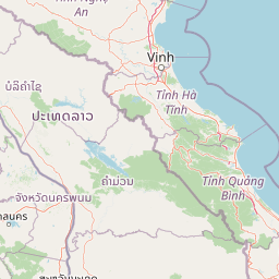
Map view of Phou Hin Poun National Biodiversity Conservation Area

Use this park location map to pinpoint Phou Hin Poun National Biodiversity Conservation Area in Laos, understand its exact geographic position, and read its mapped placement within the surrounding landscape more clearly.

Pigeon | © OpenStreetMap contributors

Location context for Phou Hin Poun National Biodiversity Conservation Area

Khammouane Province
Park atlas

Compare limestone tower karst terrain and surrounding Annamite Range protected areas

Parks Near Phou Hin Poun National Biodiversity Conservation Area and Regional Protected Landscapes

Browsing other protected areas near Phou Hin Poun National Biodiversity Conservation Area reveals connected regional terrain and limestone formations across the Annamite Range. Comparing adjacent habitats helps place local dry evergreen forests and subterranean cave systems into a wider geographic context.
National parkHà Tĩnh Province
About 86 km away#1 closest

Northeast

Vũ Quang National Park: Protected Landscape Identity and Geographic Context in Hà Tĩnh

National Park Discovery and Mapped Terrain Exploration

Investigate Vũ Quang National Park, a key protected area situated in Hà Tĩnh Province. This page provides detailed insight into the park's designation as a national park, focusing on its mapped boundaries, surrounding natural landscapes, and contribution to the regional geography. It serves as a vital resource for understanding the park's protected landscape characteristics and its place within Vietnam's atlas of conservation areas.

Area
550.28 km²
Established
2002
IUCN
II
Relief
Mountain
Protected areaBolikhamsai Province
About 89 km away#2 closest

Northwest

Nam Kading National Protected Area: An Atlas of Rugged Terrain in Bolikhamsai Province

River-carved mountain ranges and forest corridors

Nam Kading National Protected Area encompasses a vast, roadless wilderness in central Laos shaped by the Nam Kading river system. This protected landscape features deep valleys, dense evergreen forests, and dramatic relief that support a wide array of fauna and significant environmental research in the Bolikhamsai region.

Area
1,690 km²
Established
1993
IUCN
VI
Relief
Mountain
Watercolor illustration of a river flowing through a valley with green forests and distant mountains
National parkVietnam
About 106 km away#3 closest

East

Phong Nha, Kẻ Bàng National Park: Vietnam's Karst Terrain and Subterranean World

Explore protected landscapes, cave systems, and geological wonders.

Phong Nha, Kẻ Bàng National Park in Vietnam is a globally significant protected landscape, recognized by UNESCO for its exceptional karst topography and extensive cave networks. This national park features dramatic limestone mountains, deep river gorges, and some of the world's most impressive subterranean formations, offering a rich atlas of natural history and geological wonders to explore.

Area
857.54 km²
Established
2001
IUCN
II
Visitors
740K annual
National parkSakon Nakhon Province
About 118 km away#4 closest

Southwest

Phu Pha Yon National Park: Protected Landscape and Regional Geography in Sakon Nakhon Province

Explore the mapped boundaries and natural terrain of this Thai national park.

Phu Pha Yon National Park, situated in Sakon Nakhon Province, is a protected national park offering a focused point for geographic exploration. This park entity serves as a component of Thailand's broader protected area network, with its mapped boundaries and natural landscape providing essential context for regional geography studies. Understanding Phu Pha Yon National Park through its geographic setting and protected status enhances atlas-based discovery and appreciation of its place within the Khorat Plateau.

Area
829 km²
Established
1988
IUCN
II
Visitors
5K annual
National parkSakon Nakhon Province
About 118 km away#5 closest

Southwest

Phu Phan National Park: Thailand's Protected Mountain Landscape and Natural Atlas Entry

Explore dry dipterocarp forest and unique terrain in Sakon Nakhon.

Phu Phan National Park offers a detailed look into Thailand's northeastern geography, characterized by its mountainous terrain and extensive dry dipterocarp forests. As a national park, it represents a vital protected landscape within Sakon Nakhon Province, showcasing unique geological formations and providing a rich context for atlas-based exploration. Discover the park's mapped boundaries, its ecological significance, and the distinct natural features that define this prominent Isan region protected area.

Area
665 km²
Established
1972
IUCN
II
Visitors
4.9K annual
National parkNghệ An Province
About 132 km away#6 closest

North

Pù Mát National Park: National Park Protected Landscape and Geographic Mapping

Explore Nghệ An Province's protected area context.

Pù Mát National Park is a key protected area situated in Nghệ An Province, Vietnam. This entry focuses on its role as a national park, detailing its mapped boundaries and geographic features. It serves as a vital point for understanding the distribution of protected lands and the natural landscape context within the broader regional atlas. Discover the specific geographic identity and atlas significance of Pù Mát National Park.

Area
911.13 km²
Established
2001
IUCN
II
Relief
Mountain
Protected areaSavannakhet Province
About 148 km away#7 closest

Southeast

Phou Xang He National Protected Area: Geographic Overview and Forest Landscape Mapping

Protected forest ecosystems in Savannakhet Province, Laos

Phou Xang He National Protected Area encompasses a vast, relatively undisturbed forest expanse in central Laos. This detailed look at the park's physical geography highlights its characteristic mix of deciduous and evergreen woodlands, serving as a vital habitat within the Annamite foothills region. Understand the spatial distribution of this protected landscape and its regional importance to conservation efforts across Savannakhet Province.

Area
1,180 km²
Established
1993
IUCN
VI
Access
Access unknown
National parkMukdahan Province
About 150 km away#8 closest

South

Phu Pha Thoep National Park: Mukdahan Province Protected National Park Geography

Explore its mapped protected landscape and regional context.

Phu Pha Thoep National Park is a designated national park in Thailand's Mukdahan Province, offering a distinct focus for geographic exploration. This resource provides detailed insights into its protected landscape, outlining mapped park boundaries and its integration within the regional geography. Understand the park's specific natural terrain and its value for structured atlas-style discovery, moving beyond simple location data to grasp its protected area significance.

Area
48 km²
IUCN
II
Visitors
47.6K annual
Relief
Upland

Common questions about visiting, size, designation, and location context for Phou Hin Poun National Biodiversity Conservation Area

Phou Hin Poun National Biodiversity Conservation Area FAQs for park facts, access, geography, and protected area context

Find quick answers about Phou Hin Poun National Biodiversity Conservation Area, including protected-area facts, park geography, trail and visitor context, and how the park fits into its surrounding country and regional landscape.
MoriAtlas Explorer

Continue Your Protected Areas Search Across the Global Atlas

Deepen your exploration by continuing the structured search for national parks and protected areas worldwide. Utilize the comprehensive filtering capabilities to compare different conservation landscapes and refine your understanding of global park geography. Discover more about the distribution and characteristics of protected natural areas.

Global natural geography