

Mori Atlas logo
Protected areaPhou Xang He National Protected Area

Mapping the extensive deciduous, evergreen, and dry dipterocarp forest mosaics of central Laos

Phou Xang He National Protected Area: An Atlas of Forested Landscapes in Savannakhet Province

Phou Xang He National Protected Area represents an expansive conservation landscape spanning over 1,000 square kilometres within the foothills of central Laos. This geographic atlas entry details the park's varied terrain, characterized by a complex mosaic of mixed deciduous, evergreen, and dry dipterocarp forests that provide critical refuge for rare wildlife species. The reserve connects diverse rural districts across Savannakhet Province, forming a vital ecological corridor for biodiversity and preserving the region's natural forest heritage.

mixed deciduous forestdry dipterocarp forestevergreen foresttiger habitatprimate habitatgibbon habitat

Phou Xang He National Protected Area

Protected area

Park overview

Structured park overview, official facts, and landscape profile for Phou Xang He National Protected Area

Phou Xang He National Protected Area park facts, protected area profile, and essential visitor context

Review the core facts for Phou Xang He National Protected Area, including designation, size, terrain, visitor scale, habitats, and operating context in one park-focused overview.

About Phou Xang He National Protected Area

Phou Xang He National Protected Area is one of the more expansive forest protected areas in central Laos, established to conserve a substantial tract of forested landscape within Savannakhet Province. Located approximately 100 kilometres east of the city of Savannakhet near the village of Phalan, the park extends across parts of five districts: Assaphone, Thaphalanxay, Phin, Xepon, and Viraboury. With a current estimated area of around 1,180 square kilometres, it offers one of the larger continuous forest blocks in the region, an important feature in a country where habitat fragmentation is a growing concern.

The reserve protects a layered mosaic of forest types, with mixed deciduous forest covering the largest portion of the landscape and being complemented by evergreen stands and classic dry dipterocarp woodlands. This habitat mix is characteristic of lowland central Laos and supports a wide spectrum of ecological niches, from closed-canopy evergreen slopes to more open, seasonally dry dipterocarp zones. The combination of large size and relatively low levels of disturbance makes the park especially valuable for species that require extensive ranges and minimal human pressure.

Phou Xang He has been positioned as a national protected area under IUCN Category VI, a classification that recognises sustainable use of natural resources alongside conservation goals. Its management approach aims to balance the protection of threatened species with the continued presence of local communities, including the Phu Tai and Katang ethnic groups whose livelihoods are closely tied to the surrounding forest. The park has also been promoted as an ecotourism destination, reflecting its appeal as both a biodiversity stronghold and a place where visitors can engage with the natural and cultural character of central Laos.

In a regional context where many protected areas face significant pressures, Phou Xang He's relative lack of development and its distance from major roads have helped preserve its ecological integrity. While challenges remain, including local hunting, forest product harvesting, and potential expansion of infrastructure, the park remains a key component of Laos' network of national biodiversity conservation areas and a meaningful site for long-term species persistence in the Annamite foothills region.

Quick facts and research context for Phou Xang He National Protected Area

Phou Xang He is a national protected area situated about 100 kilometres east of Savannakhet in central Laos. Designated on 29 October 1993, it is classified under IUCN Category VI as a protected area with sustainable use of natural resources. The reserve straddles parts of five districts in Savannakhet Province and is centred near the village of Phalan.

The park is distinguished by its mix of evergreen, mixed deciduous, and dry dipterocarp forest, with mixed deciduous forest covering the largest share of the landscape. It supports populations of threatened large mammals such as Asian elephant, Indochinese tiger, leopard, clouded leopard, gaur, and banteng, alongside rare primates including the black crested gibbon, François' langur, and pygmy slow loris. The area also hosts the Phu Tai and Katang ethnic groups and is promoted as an ecotourism destination.

Protection and recognition

Documented terrestrial protection scope and official designation metrics for Phou Xang He

Phou Xang He National Protected Area Protection Status and International Recognition

Phou Xang He National Protected Area maintains a documented terrestrial protection scope within the regional conservation network. Structured records outline the official protection status, management scope, and international designation data available for the reserve.

Protection details

Protection scope
Terrestrial
Transboundary protection
No
Park context

Deeper park guide and search-rich context for Phou Xang He National Protected Area

Phou Xang He National Protected Area history, landscape, wildlife, and travel context

Explore Phou Xang He National Protected Area through its history, landscape character, ecosystems, wildlife, conservation priorities, cultural context, and seasonal travel timing in a structured park guide built for atlas discovery and search intent.

Why Phou Xang He National Protected Area stands out

Phou Xang He is best known for its large, mostly undisturbed forest cover that provides habitat for some of Southeast Asia's most threatened mammals. Its mixed deciduous, evergreen, and dry dipterocarp landscapes support species such as Asian elephant, Indochinese tiger, clouded leopard, black crested gibbon, and François' langur, giving the reserve an outsized role in maintaining wildlife populations in central Laos. The park is also recognised for the cultural presence of the Phu Tai and Katang ethnic groups living within and around its boundaries, and for being promoted as one of the country's principal ecotourism destinations. This combination of intact forest ecosystems, significant biodiversity, and resident local communities defines the park's reputation.

Phou Xang He National Protected Area history and protected-area timeline

Phou Xang He was established as a national protected area in Laos on 29 October 1993, placing it within the country's system of National Biodiversity Conservation Areas. Its designation reflects the national recognition of the area's importance for forest conservation, watershed protection, and the long-term survival of threatened wildlife species in central Laos.

Since its designation, the park has been managed under Laos' framework for protected areas, which combines conservation of natural resources with regulated use and engagement of local communities. The presence of the Phu Tai and Katang ethnic groups within the park's broader landscape has shaped local relationships with the reserve, and the area has also been developed as one of Laos' identified ecotourism destinations.

More recent planning has acknowledged the pressures facing the park, including potential infrastructure development such as road improvement. These concerns underscore the ongoing need for management that addresses both conservation goals and the socioeconomic context of surrounding communities.

Phou Xang He National Protected Area landscape and geographic character

The geography of Phou Xang He is shaped by the foothills and lowland forest terrain typical of central Laos. The park lies east of Savannakhet and extends across multiple administrative districts, indicating a broad and varied topographic footprint rather than a compact single catchment. Its setting in the Annamite foothills region gives rise to a rolling forest landscape that transitions between elevations supporting different forest types.

A defining feature of the park's physical environment is its mosaic of evergreen, mixed deciduous, and dry dipterocarp forests. Mixed deciduous forest predominates, accounting for nearly half of the park's area, while evergreen pockets and seasonally dry dipterocarp stands complete the forested cover. This combination of forest types reflects the seasonal monsoon climate of the region, in which wetter evergreen refuges sit alongside broad stretches of dry dipterocarp woodland that lose their leaves during the dry season.

Rivers and seasonal streams shape the drainage patterns of the reserve, with the village of Phalan serving as one of the nearby reference points and the broader landscape connecting to the rural landscapes of Assaphone, Thaphalanxay, Phin, Xepon, and Viraboury districts. The result is a relatively intact forested expanse that retains the open vistas, dry-season woodland character, and continuous canopy typical of larger central Lao protected areas.

Phou Xang He National Protected Area ecosystems, habitats, and plant life

Phou Xang He protects a layered ecological system in which mixed deciduous forest dominates, complemented by evergreen stands and extensive dry dipterocarp woodlands. The mixed deciduous forest, which covers approximately 44 percent of the park, forms the backbone of the reserve's ecological character, while evergreen forest provides year-round canopy cover and dry dipterocarp forests create seasonally open habitats that are crucial for many native species.

The combination of these forest types supports a wide range of ecological niches. Closed-canopy evergreen areas maintain moisture and food resources for primates and other forest-dependent species, while the deciduous and dipterocarp mosaics offer diverse fruiting and browsing opportunities for ungulates and large carnivores. The presence of large, unbroken tracts of forest is itself a major ecological asset, allowing species that require extensive home ranges to persist within the park.

The drainage system and seasonal rainfall of central Laos also influence the park's ecology, supporting riparian vegetation along watercourses and creating transitional zones between drier and wetter vegetation types. This ecological variability is a central part of why Phou Xang He is considered an important contributor to broader regional biodiversity in the Annamite foothills and adjacent landscapes.

Phou Xang He National Protected Area wildlife and species highlights

Phou Xang He supports an exceptionally rich assemblage of mammals and birds, several of which are globally threatened and depend on large, undisturbed forest tracts for survival. Among its most notable residents are Asian elephant, Indochinese tiger, leopard, and clouded leopard, all of which are classic wide-ranging species that benefit from the park's substantial size and relatively intact habitat.

The park is also home to several rare primates, including the black crested gibbon, François' langur, pygmy slow loris, douc langur, and macaques. These species give Phou Xang He particular significance in the regional context of primate conservation, as several are restricted to limited ranges and threatened by hunting and habitat loss elsewhere.

Other mammalian species recorded in the reserve include giant muntjac, gaur, banteng, dhole, Asian black bear, sun bear, and large-spotted civet, illustrating the park's role as a refuge for both charismatic megafauna and lesser-known mammals. Birdlife includes threatened species such as the red-collared woodpecker, alongside more widespread forest birds like the ratchet-tailed treepie and mountain fulvetta.

The combination of high species diversity and the presence of threatened taxa makes Phou Xang He an important site for wildlife conservation in central Laos, especially as habitat pressure intensifies across much of the surrounding region.

Phou Xang He National Protected Area conservation status and protection priorities

Phou Xang He plays a meaningful role in regional conservation as one of the more intact forested protected areas in central Laos. Its large area and relatively undisturbed condition provide important refuge for threatened mammals and birds that would struggle to persist in smaller, more fragmented reserves. The park's inclusion in Laos' national system of protected areas gives it formal recognition and management support under the country's biodiversity conservation framework.

The IUCN Category VI designation applied to the park acknowledges that sustainable use of natural resources is part of its management approach, rather than strict exclusion of human activity. This classification reflects the reality of communities living within and around the reserve, and the importance of engaging local people in conservation outcomes.

Despite its current ecological value, the park faces ongoing threats that include local hunting driven by poverty, harvesting of forest products, agricultural expansion, and the potential risk of road improvement projects opening access for illegal wildlife and timber trade. Addressing these pressures is central to maintaining the park's conservation significance over the longer term.

The presence of rare primates, wide-ranging carnivores, and large ungulates ensures that Phou Xang He contributes to the regional survival of species that are under serious pressure throughout mainland Southeast Asia. Its continued protection is therefore relevant not only at the national level but also within broader continental conservation strategies.

Phou Xang He National Protected Area cultural meaning and human context

Phou Xang He is home to ethnic Phu Tai and Katang communities, whose presence within and around the protected area gives the park a distinct cultural dimension. These communities represent the human heritage of the landscape and have long-standing relationships with the surrounding forests, including traditional patterns of resource use, settlement, and land stewardship.

The coexistence of these ethnic groups with the protected area is reflected in the park's IUCN Category VI designation, which explicitly accommodates sustainable use of natural resources alongside conservation. This shared landscape underscores the importance of local governance, customary practices, and community engagement in achieving the park's long-term conservation goals.

The cultural dimension of Phou Xang He also plays into its role as an ecotourism destination, where visitors can engage with both the forest environment and the traditions of the communities that inhabit it.

Top sights and standout views in Phou Xang He National Protected Area

Phou Xang He stands out for its scale and ecological integrity among Laos' protected forest landscapes. With nearly half of its area covered in mixed deciduous forest and additional evergreen and dry dipterocarp habitats, the park offers one of the most extensive and varied forest mosaics in Savannakhet Province.

Its wildlife profile is particularly strong, encompassing threatened species such as Asian elephant, Indochinese tiger, clouded leopard, black crested gibbon, François' langur, and pygmy slow loris. The combination of rare primates, wide-ranging carnivores, and significant ungulate populations positions Phou Xang He as a regional stronghold for biodiversity conservation.

The park's identity is further enriched by the presence of the Phu Tai and Katang ethnic groups and its status as an ecotourism destination, linking conservation with cultural heritage and low-impact visitation.

Best time to visit Phou Xang He National Protected Area

Phou Xang He sits in a region with a distinct tropical monsoon climate, and the dry-season period, broadly corresponding to the cooler and drier months, is typically the most accessible time to experience dry dipterocarp woodland and deciduous forest landscapes, when leaves thin, visibility into the forest improves, and surface travel becomes easier.

The wet season, by contrast, brings lush green canopies to the evergreen and mixed deciduous forest areas, and can be rewarding for those interested in active forest ecosystems and bird activity, though access becomes more challenging. Travellers interested in birdlife may find periods associated with seasonal movements particularly engaging, while those drawn to the dry dipterocarp forests and open woodland scenes may prefer the dry months.

Ultimately, the choice of timing depends on whether visitors prioritise scenery, forest colour, or ease of access, with the dry months generally offering the most comfortable conditions for exploring the park.
Monthly climate preview

Long term temperature and precipitation measurements across twelve months

Phou Xang He National Protected Area Climate Normals and Annual Weather Rhythm

Representative coordinate records show average temperatures ranging from 20.38 to 28.38 degrees Celsius alongside distinct monthly precipitation variations. Examining the complete twelve month profile provides deeper insight into long term meteorological patterns across the protected landscape.
Annual mean25 °C
20 °C28 °C
Jan20°
Feb23°
Mar26°
Apr28°
May28°
Jun27°
Jul26°
Aug26°
Sep26°
Oct24°
Nov23°
Dec20°
Warmest month
April

28.4 °C

Coolest month
January

20.4 °C

Wettest month
August

8.4 mm/day

Driest month
January

0.5 mm/day

Park location guide

Geography guide, regional context, and park location map for Phou Xang He National Protected Area

Phou Xang He National Protected Area park geography, regions, and map view in Laos

Understand where Phou Xang He National Protected Area sits in Laos through a broader geographic reading of the surrounding landscape, nearby location context, and its mapped position within the national park landscape.

How Phou Xang He National Protected Area fits into Laos

Laos, officially the Lao People's Democratic Republic, is a unitary communist state in mainland Southeast Asia. As the only landlocked country in the region, it shares borders with Myanmar, China, Vietnam, Cambodia, and Thailand. The country has a population of over 7 million and is known for its mountainous terrain, Buddhist heritage, and three UNESCO World Heritage Sites: Luang Prabang, Vat Phou, and the Plain of Jars. The Boten, Vientiane railway completed in 2021 connects Laos to China.

Wider geography shaping Phou Xang He National Protected Area in Laos

Laos is located in mainland Southeast Asia, occupying a mountainous and forested landscape. It is bordered by Myanmar and China to the northwest, Vietnam to the east, Cambodia to the southeast, and Thailand to the west and southwest. As the only landlocked country in Southeast Asia, it has no coastline. The country lies at approximately 17.967°N latitude and 102.6°E longitude.

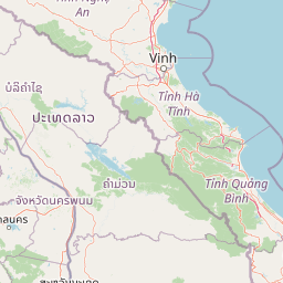
Map view of Phou Xang He National Protected Area

Use this park location map to pinpoint Phou Xang He National Protected Area in Laos, understand its exact geographic position, and read its mapped placement within the surrounding landscape more clearly.

Pigeon | © OpenStreetMap contributors

Location context for Phou Xang He National Protected Area

Savannakhet Province
Park atlas

Compare regional forest reserves, wildlife habitats, and connected conservation areas

Parks Near Phou Xang He National Protected Area and Surrounding Protected Landscapes

Browse nearby national parks and protected areas sharing the lowland forest terrain and wildlife corridors of central Laos. Continuing the comparison reveals broader regional ecosystems and related conservation landscapes across the surrounding provinces.
Watercolor illustration of a river flowing through a valley with green forests and distant mountains
National parkVietnam
About 72 km away#1 closest

Northeast

Phong Nha, Kẻ Bàng National Park: Vietnam's Karst Terrain and Subterranean World

Explore protected landscapes, cave systems, and geological wonders.

Phong Nha, Kẻ Bàng National Park in Vietnam is a globally significant protected landscape, recognized by UNESCO for its exceptional karst topography and extensive cave networks. This national park features dramatic limestone mountains, deep river gorges, and some of the world's most impressive subterranean formations, offering a rich atlas of natural history and geological wonders to explore.

Area
857.54 km²
Established
2001
IUCN
II
Visitors
740K annual
National parkMukdahan Province
About 112 km away#2 closest

West

Phu Pha Thoep National Park: Mukdahan Province Protected National Park Geography

Explore its mapped protected landscape and regional context.

Phu Pha Thoep National Park is a designated national park in Thailand's Mukdahan Province, offering a distinct focus for geographic exploration. This resource provides detailed insights into its protected landscape, outlining mapped park boundaries and its integration within the regional geography. Understand the park's specific natural terrain and its value for structured atlas-style discovery, moving beyond simple location data to grasp its protected area significance.

Area
48 km²
IUCN
II
Visitors
47.6K annual
Relief
Upland
National parkAmnat Charoen Province
About 121 km away#3 closest

Southwest

Phu Sa Dok Bua National Park: National Park with Mapped Protected Boundaries

Explore protected landscapes in Amnat Charoen Province, Thailand.

Discover Phu Sa Dok Bua National Park, a designated national park situated within the geographic context of Amnat Charoen Province. This profile focuses on the park's protected area identity and its mapped boundaries, offering essential geographic information for atlas-based exploration and understanding its role within Thailand's conservation landscape.

Area
231 km²
Established
1992
IUCN
II
Visitors
1.8K annual
Protected areaSalavan Province
About 134 km away#4 closest

South

Phou Xieng Thong National Protected Area: Geographic Boundaries and Regional Landscape Context

A unique Mekong River protected area in Salavan Province

Phou Xieng Thong National Protected Area defines a unique geographic corridor in southern Laos. Spanning across Salavan and Champasak provinces, the park features a dramatic vertical transition from the Mekong River boundary up to an interior plateau. Its landscape, characterized by sheer cliffs and open rocky flats, serves as an essential ecological bridge and Important Bird Area within the regional conservation network.

Area
1,200 km²
Established
1993
IUCN
VI
Relief
Upland
Wildlife reserveKhammouane Province
About 148 km away#5 closest

Northwest

Phou Hin Poun National Biodiversity Conservation Area: Khammouane Province Landscapes

Tower karst geology and Annamite Range biodiversity

Delve into the geography of Phou Hin Poun National Biodiversity Conservation Area, where dramatic stone ridges and dense forest patches define a unique karst ecosystem. Located in Khammouane Province, this wildlife reserve stands as a major center for scientific discovery and protected habitat monitoring in central Laos.

Area
1,801.49 km²
Established
1993
IUCN
VI
Relief
Mountain
National parkUbon Ratchathani Province
About 159 km away#6 closest

South

Pha Taem National Park: Mapped Protected Landscape in Ubon Ratchathani

National park exploration and geographic context

Pha Taem National Park serves as a distinct protected area within Ubon Ratchathani Province, offering a focused lens for geographic discovery. Understand its specific location, mapped boundaries, and the surrounding natural landscape context that defines this national park. This entry supports detailed atlas exploration of Thailand's protected territories.

Area
340 km²
Established
1991
IUCN
II
Visitors
180.2K annual
National parkHà Tĩnh Province
About 167 km away#7 closest

North

Vũ Quang National Park: Protected Landscape Identity and Geographic Context in Hà Tĩnh

National Park Discovery and Mapped Terrain Exploration

Investigate Vũ Quang National Park, a key protected area situated in Hà Tĩnh Province. This page provides detailed insight into the park's designation as a national park, focusing on its mapped boundaries, surrounding natural landscapes, and contribution to the regional geography. It serves as a vital resource for understanding the park's protected landscape characteristics and its place within Vietnam's atlas of conservation areas.

Area
550.28 km²
Established
2002
IUCN
II
Relief
Mountain
National parkUbon Ratchathani Province
About 170 km away#8 closest

South

Kaeng Tana National Park: Mapped Protected Landscape in Ubon Ratchathani Province

Explore Thailand's national park geography and boundaries.

Kaeng Tana National Park is a designated national park located in Ubon Ratchathani Province, Thailand. This atlas-focused content helps users understand its unique protected landscape identity and geographic setting. Explore the mapped context of Kaeng Tana National Park, contributing to a structured understanding of conservation areas and natural terrain within Thailand's broader geography.

Area
80 km²
Established
1981
IUCN
II
Visitors
31.2K annual

Common questions about visiting, size, designation, and location context for Phou Xang He National Protected Area

Phou Xang He National Protected Area FAQs for park facts, access, geography, and protected area context

Find quick answers about Phou Xang He National Protected Area, including protected-area facts, park geography, trail and visitor context, and how the park fits into its surrounding country and regional landscape.
MoriAtlas Explorer

Continue Your Protected Areas Search Across the Global Atlas

Deepen your exploration by continuing the structured search for national parks and protected areas worldwide. Utilize the comprehensive filtering capabilities to compare different conservation landscapes and refine your understanding of global park geography. Discover more about the distribution and characteristics of protected natural areas.

Global natural geography

