

Mori Atlas logo
National parkPioneer Peaks National Park

Discover the mapped boundaries and natural terrain context of this Australian national park.

Pioneer Peaks National Park: Queensland's Protected Landscape and Regional Geography

Pioneer Peaks National Park stands as a significant protected area within Queensland, Australia. This page offers an in-depth look at its geographic identity, focusing on its mapped boundaries and the natural landscape it encompasses. Understand how Pioneer Peaks National Park contributes to the rich tapestry of protected lands across northeastern Australia and within the wider atlas.

Queensland national parksAustralian protected areasMountain landscapesIUCN Category IIQueensland Parks and Wildlife ServicePioneer Ranges

Pioneer Peaks National Park

National park

Park overview

Structured park overview, official facts, and landscape profile for Pioneer Peaks National Park

Pioneer Peaks National Park park facts, protected area profile, and essential visitor context
Review the core facts for Pioneer Peaks National Park, including designation, size, terrain, visitor scale, habitats, and operating context in one park-focused overview.

About Pioneer Peaks National Park

Pioneer Peaks National Park protects a section of the Pioneer Ranges in Queensland, an area characterised by its rugged mountain terrain and surrounding forested landscapes. The park's most prominent feature is Mount Blackwood, which provides a distinctive visual landmark within the protected area. Established in 1992, the park represents Queensland's commitment to preserving representative samples of the state's diverse landscapes and ecosystems. The protected area contributes to the broader conservation network in the region, helping to maintain habitat connectivity and protect characteristic Queensland bushland environments. The park's location within the Pioneer Ranges places it in a region historically associated with both natural exploration and pastoral development, though the protected status now ensures the landscape is managed primarily for conservation and ecological integrity.

Quick facts and research context for Pioneer Peaks National Park

Pioneer Peaks National Park spans 18.40 square kilometres in Queensland, Australia. The park was established in 1992 and is managed by the Queensland Parks and Wildlife Service under IUCN Category II protection. The park is located 833 kilometres northwest of Brisbane, with Mount Blackwood serving as its most notable geographic feature. The park falls within the Pioneer Ranges region of Queensland, an area known for its distinctive mountain formations and surrounding bushland.

Park context

Deeper park guide and search-rich context for Pioneer Peaks National Park

Pioneer Peaks National Park history, landscape, wildlife, and travel context
Explore Pioneer Peaks National Park through its history, landscape character, ecosystems, wildlife, conservation priorities, cultural context, and seasonal travel timing in a structured park guide built for atlas discovery and search intent.

Pioneer Peaks National Park history and protected-area timeline

Pioneer Peaks National Park was established in 1992 as part of Queensland's expanding network of protected areas. The creation of the park reflected a broader movement in Australian conservation policy during the late twentieth century to identify and protect representative examples of the nation's diverse natural landscapes. The establishment of the park formalised protection for the Pioneer Ranges environment, including the distinctive Mount Blackwood area. The park is now managed by the Queensland Parks and Wildlife Service, which oversees conservation activities, visitor management, and ecological monitoring within the protected area.

Pioneer Peaks National Park landscape and geographic character

The landscape of Pioneer Peaks National Park is defined by the Pioneer Ranges, a mountain formation in Queensland that gives the park its name. The terrain features rugged peaks, slopes, and ridges characteristic of this part of Queensland. Mount Blackwood stands as the park's most notable topographic feature, rising prominently above the surrounding landscape. The area encompasses forested slopes and natural bushland, typical of the Queensland tropical to subtropical environment. The combination of mountain peaks, forested terrain, and the distinctive Queensland bushland character defines the physical environment of the park.

Pioneer Peaks National Park ecosystems, habitats, and plant life

Pioneer Peaks National Park protects portions of the Queensland bushland environment within the Pioneer Ranges region. The park's natural environment includes forested areas that support typical Queensland flora species adapted to the region's climate and conditions. The protected area contributes to the conservation of characteristic ecosystems found in this part of Queensland, helping to preserve the natural character of the Pioneer Ranges landscape.

Pioneer Peaks National Park conservation status and protection priorities

Pioneer Peaks National Park operates under IUCN Category II protection, which designates it as a national park focused on ecosystem protection and conservation. The park contributes to Queensland's protected area network, helping to maintain representative examples of the state's natural landscapes. Management by the Queensland Parks and Wildlife Service ensures that conservation objectives are maintained while providing for appropriate public enjoyment of the area.

Top sights and standout views in Pioneer Peaks National Park

The standout feature of Pioneer Peaks National Park is Mount Blackwood, a prominent peak that forms a defining element of the park's identity and landscape character. The park protects a section of the Pioneer Ranges, offering visitors views of rugged mountain terrain and Queensland bushland. The protected status ensures the preservation of this distinctive landscape for future generations.

Park location guide

Geography guide, regional context, and park location map for Pioneer Peaks National Park

Pioneer Peaks National Park park geography, regions, and map view in Australia
Understand where Pioneer Peaks National Park sits in Australia through a broader geographic reading of the surrounding landscape, nearby location context, and its mapped position within the national park landscape.

How Pioneer Peaks National Park fits into Australia

Australia is a constitutional monarchy and federal parliamentary democracy comprising six states and ten territories. With a population of nearly 28 million, it is one of the world's most urbanised countries, with most people concentrated on the eastern seaboard. The country has a high Human Development Index and is known for its cultural diversity, ancient Aboriginal heritage, and unique wildlife.

Wider geography shaping Pioneer Peaks National Park in Australia

Australia occupies the entire Australian continent, the island of Tasmania, and numerous smaller islands. It is the world's flattest and driest inhabited continent, featuring vast deserts in the interior (the Outback), tropical rainforests along the eastern coast, and a coastline bordering the Indian and Pacific Oceans.

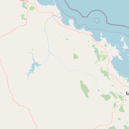
Map view of Pioneer Peaks National Park

Use this park location map to pinpoint Pioneer Peaks National Park in Australia, understand its exact geographic position, and read its mapped placement within the surrounding landscape more clearly.

Pigeon | © OpenStreetMap contributors

Location context for Pioneer Peaks National Park

Queensland
Park atlas

Trace adjacent protected landscapes and compare regional park geography around Pioneer Peaks National Park in Queensland.

Discover Other National Parks and Protected Areas Near Pioneer Peaks National Park
Explore a curated list of national parks and protected areas geographically adjacent to Pioneer Peaks National Park, allowing you to broaden your understanding of Queensland's diverse conservation landscapes. Compare mountain terrain, forested slopes, and distinct bushland across the wider region, providing essential context for your atlas-style park discovery journey.
National parkQueensland

Mount Ossa National Park: A Protected Landscape within Queensland's Natural Atlas

Discover its mapped boundaries and regional geographic context.

Mount Ossa National Park stands as a key protected entity within Queensland, Australia, offering rich opportunities for atlas-based exploration. This page details its designation as a national park and provides context for its mapped landscape, allowing for a deeper understanding of its geographic significance in northeastern Australia. Explore the park's role in the regional conservation effort and its place within the broader Australian protected areas network.

Area
4.96 km²
Established
1994
IUCN
II
Relief
Mountain
National parkQueensland

Cape Hillsborough National Park: Queensland's Volcanic Peninsula National Park

Mapped geography and protected landscape context in Central Queensland.

Cape Hillsborough National Park is a notable protected area defined by its unique volcanic peninsula landform in Queensland. Its rugged terrain features dense rainforest interiors that contrast with the surrounding coastal environments and tidal zones. As a national park, it offers an excellent opportunity to study landscape context, mapped geological features, and the distribution of protected natural areas within the Central Queensland region.

Area
10.22 km²
Established
1985
IUCN
II
Relief
Upland
National parkQueensland

Mount Martin National Park: A Protected National Park in Queensland's Natural Landscape

Explore its mapped boundaries and regional geographic context.

Mount Martin National Park represents a distinct protected area within the Australian state of Queensland. This page offers focused insight into its role as a national park, providing users with a clear understanding of its geographic setting and mapped boundaries. Delve into the specific landscape characteristics and conservation context that define Mount Martin National Park, enriching your atlas exploration of Queensland's protected regions.

Area
4.76 km²
Established
1994
IUCN
II
Relief
Mountain
National parkQueensland

Reliance Creek National Park: Preserving Queensland's Coastal Palm Forest Ecosystem

Mapped protected landscape on Queensland's central coast.

Reliance Creek National Park is a critical conservation site in Queensland, safeguarding the most significant remaining area of coastal palm forest. This compact national park protects a unique subtropical ecosystem that has largely vanished from the surrounding regional landscape. Users can explore its precise location and geographic context, understanding its importance as a preserved natural heritage and a testament to the original coastal plain environment.

Area
0.14 km²
Established
1980
IUCN
II
Access
Remote access
National parkQueensland

Eungella National Park: National Park Protected Landscape and Queensland Geography

Explore mapped boundaries and regional landscape context.

Gain a detailed understanding of Eungella National Park as a protected landscape within Queensland. This page focuses on its mapped boundaries and geographic positioning, offering an atlas-oriented view for those interested in regional park discovery. Delve into the specific natural terrain and protected area context that characterizes Eungella National Park, enhancing your geographic comprehension.

Area
517 km²
Established
1941
IUCN
II
Relief
Mountain
National parkQueensland

Round Top Island National Park: Protected Island Landscape in Queensland

Explore mapped boundaries and regional conservation context.

Round Top Island National Park preserves the natural character of a small coastal island in Queensland's Coral Sea region. This national park offers a clear example of an entire island protected area, contributing to the broader atlas of Australian conservation landscapes. Understanding its mapped boundaries and its place within North Queensland's geography provides insight into the diversity of protected island ecosystems preserved for their ecological significance.

Area
0.19 km²
IUCN
II
Relief
Mixed relief
Scope
Mixed
National parkQueensland

Repulse Island National Park: Queensland's Coastal Protected Area and Mapped Geography

Explore this key national park's mapped boundaries and island landscape.

Repulse Island National Park is an important protected natural area offering unique insights into coastal island geography within Queensland's expansive conservation network. Established as a national park, it signifies a commitment to preserving representative natural landscapes. This page focuses on the mapped boundaries, regional geographic context, and the protected landscape identity of Repulse Island National Park, providing a detailed entry point for atlas-driven discovery of Australia's protected areas.

Area
1.51 km²
Established
1994
IUCN
II
Scope
Terrestrial
National parkQueensland

Smith Islands National Park: Queensland Coastal Protected Area Map

Discover the mapped geography and island landscapes of North Queensland.

Smith Islands National Park represents a significant protected island landscape off the coast of Queensland, Australia. This page allows for detailed exploration of its geographic features, mapped boundaries, and role as a national park within the North Queensland region's atlas of natural areas. Understand the unique character of these tropical islands and their place within Australia's network of preserved coastal environments.

Area
18.7 km²
IUCN
II
Scope
Terrestrial

Common questions about visiting, size, designation, and location context for Pioneer Peaks National Park

Pioneer Peaks National Park FAQs for park facts, access, geography, and protected area context
Find quick answers about Pioneer Peaks National Park, including protected-area facts, park geography, trail and visitor context, and how the park fits into its surrounding country and regional landscape.
MoriAtlas Explorer

Continue Your Protected Areas Search Across the Global Atlas

Deepen your exploration by continuing the structured search for national parks and protected areas worldwide. Utilize the comprehensive filtering capabilities to compare different conservation landscapes and refine your understanding of global park geography. Discover more about the distribution and characteristics of protected natural areas.

Global natural geography