
Mori Atlas logo
Protected areaPirongia Forest Park

Tracing volcanic peaks, native podocarp forests, and limestone terrain across the Waikato region.

Pirongia Forest Park: A Comprehensive Geographic Atlas of New Zealand Protected Landscapes

Pirongia Forest Park stands as a vital protected area in the western Waikato, encompassing two distinct volcanic landforms: the inland mass of Mount Pirongia and the coastal escarpment of Mount Karioi. This geographic analysis maps the transition between diverse forest types, ranging from lowland podocarp remnants to the northern limits of southern beech. Spanning thousands of hectares, the terrain features deeply incised valleys, river systems, and iconic limestone formations that define the natural boundaries of this significant North Island reserve.

forest parkpodocarp forestnative bushWaikatovolcanic peakssummit walking
A colorful vector-style illustration depicting a dense forest scene with various trees, fern fronds, a winding stream, and a large hill in the background under a sky with clouds and a sun.

Pirongia Forest Park

Protected area

Park overview

Structured park overview, official facts, and landscape profile for Pirongia Forest Park

Pirongia Forest Park park facts, protected area profile, and essential visitor context

Review the core facts for Pirongia Forest Park, including designation, size, terrain, visitor scale, habitats, and operating context in one park-focused overview.

About Pirongia Forest Park

Pirongia Forest Park is a substantial protected forest landscape in the western Waikato region of New Zealand's North Island. Reaching roughly 16,773 hectares across four blocks, it functions as one of the most important surviving remnants of native lowland and hill forest in an area that has otherwise been heavily converted to farmland. The park's identity is shaped by the interplay between inland and coastal landscapes: the main block wraps around Mount Pirongia, an inland volcanic peak, while the Te Maunga o Karioi Block extends toward Mount Karioi, a steep volcanic remnant that rises above the Tasman Sea near Raglan.

Ecologically, Pirongia is a forest park of distinctive character. Its climate is mild and exceptionally wet, especially around Mount Pirongia where annual rainfall regularly exceeds 2,400 millimetres. This moisture sustains a dense cover of native bush, much of it old-growth podocarp forest dominated by rimu, totara, kahikatea, and tawa, with a rich understorey of tree ferns and smaller broadleaf species. The forest habitat supports a wide community of native birds, including common species such as kererū, tūī, bellbirds, fantails, morepork, and silvereyes, alongside less common residents like grey warblers, tomtits, and the occasional kākā.

The park is also a notable biogeographic boundary. It lies near the natural southern limit of kauri forest and, toward its southern reaches, increasingly includes southern beech, creating a transition between two of New Zealand's most distinctive forest types. Walking tracks such as the Bell Track pass through this forest and lead to the tallest recorded native tree in New Zealand, a kahikatea of about 66.5 metres. Shorter walks, including the Nikau Track (which is also suitable for cycling), and routes to the Kaniwhaniwha limestone caves, make different parts of the park accessible to a wide range of visitors. While the park shares the wider landscape with the nearby Wairēinga / Bridal Veil Falls Scenic Reserve, that waterfall reserve is administered separately and is not part of Pirongia Forest Park itself.

Quick facts and research context for Pirongia Forest Park

Pirongia Forest Park was established in 1971 and is administered by the New Zealand Department of Conservation. It covers roughly 16,773 hectares across four distinct blocks of land, with the main Pirongia block surrounding Mount Pirongia and additional areas around Mount Karioi near Raglan.

The park is located in the western Waikato on the North Island of New Zealand, near the small township of Pirongia. Its climate is mild and wet, with annual rainfall exceeding 2,400 millimetres around Mount Pirongia, and the terrain spans volcanic peaks, forested ridges, limestone formations, and streams draining toward the coast. Nearby, but separate from the park, lies Wairēinga / Bridal Veil Falls Scenic Reserve.

Protection and recognition

Terrestrial protected area classification and management scope

Pirongia Forest Park Protection Status and Conservation Recognition

Pirongia Forest Park maintains a documented terrestrial protection status within the regional conservation network. Structured management records outline the official designation framework and available international recognition details.

Protection details

Protection scope
Terrestrial
Transboundary protection
No
Park context

Deeper park guide and search-rich context for Pirongia Forest Park

Pirongia Forest Park history, landscape, wildlife, and travel context

Explore Pirongia Forest Park through its history, landscape character, ecosystems, wildlife, conservation priorities, cultural context, and seasonal travel timing in a structured park guide built for atlas discovery and search intent.

Why Pirongia Forest Park stands out

Pirongia Forest Park is especially known for its extensive podocarp and broadleaf forest dominated by rimu, totara, kahikatea, and tawa, together with a thick understorey of tree ferns. The park sits at a significant biogeographic crossroads: it lies near the natural southern limit of kauri forest while also marking the northern edge of New Zealand's southern beech range, with beech becoming increasingly common toward the south. The park is also distinguished by two contrasting volcanic landmarks, Mount Pirongia inland and Mount Karioi on the coast, and by the presence of the tallest recorded native tree in New Zealand, a towering kahikatea reached via the Bell Track. Combined, these features make the park a focal point for forest experience, summit walking, and appreciation of Waikato's native bush.
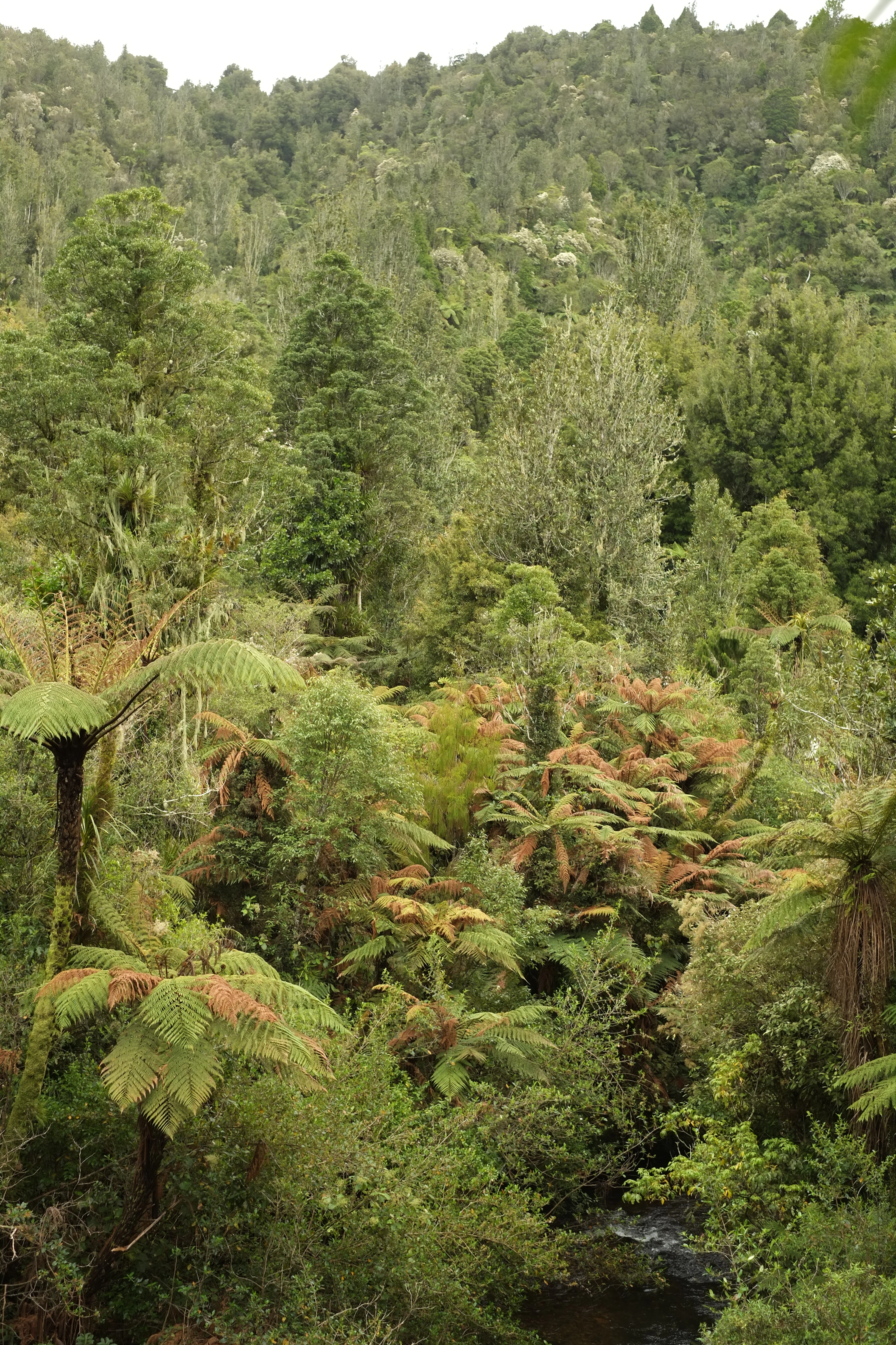
A dense forest scene showing numerous tree ferns with green and reddish fronds in the foreground, a small stream at the bottom right, and a hillside covered in tall trees in the background.
Dense native bush featuring tree ferns and a forested hillside in Pirongia Forest Park.

Pirongia Forest Park history and protected-area timeline

The lands that now form Pirongia Forest Park have a long human history. Before European colonisation, the area was occupied by Māori iwi including Ngāti Apakura, Ngāti Hikairo, and Ngāti Māhanga, whose connection to the forest, peaks, and waterways of the region remains part of the park's cultural context today. A small portion of the present park area to the northeast was included in the 1865 Waikato land confiscation; that older boundary largely defines the limit of remaining native bush in the region.

The movement toward formal protection gained pace in the early twentieth century. The summit area of Mount Pirongia was purchased in 1900, and further land was acquired over the following decades. Under the Public Reserves, Domains, and National Parks Act of 1928, the Pirongia and Wainui Domain Boards were able to buy additional land beginning in 1932. A scenic reservation covering about 2,183 acres, including roughly 1,700 acres purchased with assistance from the Bruce Trustees, was declared in 1937.

The park took its modern shape in 1971, when the core forest lands were formally set apart as Pirongia Forest Park. Later additions expanded the protected area: the Karioi block was added in 1976, bringing the park to about 14,306 hectares, and in 1984 the Tapuwaeohounuku block, also proposed to be known as Te Rauamoa Block and formerly State Forest 56, was added on either side of Kaimango Road. Together these additions created the four-block structure of the park as it is recognised today.

Pirongia Forest Park landscape and geographic character

The landscape of Pirongia Forest Park is defined by two volcanic landmarks set within a deeply forested Waikato setting. Inland, Mount Pirongia rises as the focal point of the largest block, its upper slopes and ridges cloaked in dense native forest that drops into valleys, streams, and limestone formations. Nearer the coast, Mount Karioi forms a steep, dramatic volcanic remnant standing above the Tasman Sea near Raglan, giving the park an unusual combination of inland peak and coastal escarpment.

Between these peaks, the terrain is shaped by heavy rainfall, with the Mount Pirongia area receiving over 2,400 millimetres of rain a year. This produces deeply incised stream systems, including the Kaniwhaniwha Stream with its small limestone caves, and sustained evergreen cover across the hills. Although farmland dominates much of the surrounding region, the park preserves a substantial mosaic of forest-clad ridges, valleys, and summits, with the older confiscation-era bush boundary still clearly visible in the surviving pattern of vegetation today.

Pirongia Forest Park ecosystems, habitats, and plant life

Ecologically, Pirongia Forest Park is best understood as a stronghold of Waikato lowland and hill forest. The dominant vegetation is podocarp forest, featuring rimu, totara, kahikatea, and tawa, interwoven with a dense understorey of tree ferns and other native broadleaves. This forest type, once far more widespread across the North Island, is now reduced to a network of protected remnants, of which Pirongia is one of the most significant in the western Waikato.

The park's climate, mild summers, temperate winters, and consistently high rainfall, supports a lush, multi-layered forest structure. A particular ecological feature of Pirongia is its position at a forest transition zone: it lies near the natural southern limit of kauri forest, while in the southern parts of the park, southern beech becomes an increasingly important part of the canopy. This overlap between two largely distinct New Zealand forest types gives Pirongia an unusually rich ecological character for a single protected area.

Pirongia Forest Park wildlife and species highlights

The park's forest habitats support a varied community of native birds shaped by the area's dense podocarp canopy and mild, wet climate. Common forest birds include kererū, with their distinctive deep wingbeats in the canopy, along with tūī, bellbirds, and fantails often seen along forest margins and along walking tracks. Morepork are present as nocturnal residents in the bush, while silvereyes flit through the understorey.

Less common species contribute additional biodiversity. Grey warblers and tomtits are recorded within the forest, and occasional visits by kākā add a notable presence. In the streams, introduced brown trout inhabit the Kaniwhaniwha Stream, and the park's management approach encourages recreational hunting of introduced animals such as goats in order to reduce pressure on native vegetation regeneration.

Pirongia Forest Park conservation status and protection priorities

Pirongia Forest Park plays an important conservation role within the Waikato, acting as a large refuge of native lowland and hill forest in a landscape that has been extensively converted to pastoral farming. The very existence of the park reflects the recognition that surviving bush in this part of the North Island is limited and precious, and the older confiscation boundary still largely marks where native forest has been retained.

Beyond preservation, the park supports ecological processes through its wet climate, varied terrain, and the protection of soils and waterways that would otherwise be vulnerable to erosion and runoff. Its location at a forest transition zone, between kauri forest and southern beech forest, gives it added scientific and conservation value as a place where two distinct forest communities overlap. Active management by the Department of Conservation also extends to controlling introduced species, with hunting of goats and licensing of trout fishing used as tools to maintain ecological balance within the park.

Pirongia Forest Park cultural meaning and human context

The forest, peaks, and waterways of Pirongia Forest Park carry deep significance for local Māori. Prior to colonisation, the area was occupied by iwi including Ngāti Apakura, Ngāti Hikairo, and Ngāti Māhanga, whose connection to the land persisted through generations. Māori ownership of much of the area continued after the 1865 confiscations, until progressive purchases and donations of the summit and surrounding land from the early twentieth century onward created the basis for the modern park.

Today, the place names of the park itself, including Te Maunga o Karioi Block and Tapuwaeohounuku, reflect this layered Māori heritage. Nearby landscape features, such as Mount Karioi and Mount Pirongia, remain landmarks of cultural as well as ecological identity, and the park can be understood as a place where conservation and indigenous history continue to intersect.

Top sights and standout views in Pirongia Forest Park

Pirongia Forest Park contains a number of standout qualities that give it a distinctive place among New Zealand's protected areas. Its scale is significant, with around 16,773 hectares distributed across four blocks and covering both inland volcanic peaks and coastal ranges. The park protects one of the most important surviving remnants of lowland podocarp forest in the Waikato, with rimu, totara, kahikatea, and tawa forming the backbone of an exceptionally wet, multi-layered forest canopy.

Ecologically, the park is a meeting point of two major New Zealand forest types: it lies at the natural southern limit of kauri forest while increasingly containing southern beech toward the south. It is also home to the tallest recorded native tree in New Zealand, a 66.5 metre kahikatea reached via the Bell Track, and offers access to the limestone Kaniwhaniwha Caves, the walkable summit of Mount Pirongia, and the dramatic coastal slopes of Mount Karioi near Raglan. Together these features make the park a remarkable combined destination for forest, summit, and coastal landscape experiences.

Best time to visit Pirongia Forest Park

Pirongia Forest Park's mild, wet climate means the forest experience remains evergreen throughout the year, but the character of a visit shifts with the seasons. Cooler, drier months can offer clearer views from the Mount Pirongia summit, while the wetter months emphasise the lushness of the forest, the roar of waterfalls nearby, and the volume of the birdlife active in the canopy and understorey.

For many visitors, late spring through early autumn provides a comfortable balance between settled weather and active forest life, when walking tracks such as the Bell Track to the tallest kahikatea, the Nikau Track, and the route to the Kaniwhaniwha Caves are at their most inviting. As with much of the western Waikato, weather can change quickly on the higher summits, so visitors should be prepared for changing conditions regardless of the season.

Monthly climate preview

Measured monthly climate trends and multi-year meteorological baseline data for New Zealand

Pirongia Forest Park Climate Normals, Long-Term Temperature and Precipitation Rhythm

Historical records from a representative coordinate show steady shifts in monthly temperature and precipitation throughout the annual cycle at Pirongia Forest Park. Accessing the complete twelve-month climatology dataset reveals detailed normals across every recorded interval.
Annual mean14 °C
10 °C19 °C
Jan19°
Feb19°
Mar18°
Apr15°
May13°
Jun11°
Jul10°
Aug10°
Sep12°
Oct13°
Nov15°
Dec17°
Warmest month
February

19.2 °C

Coolest month
July

9.8 °C

Wettest month
July

3.9 mm/day

Driest month
January

2.2 mm/day

Park location guide

Geography guide, regional context, and park location map for Pirongia Forest Park

Pirongia Forest Park park geography, regions, and map view in New Zealand

Understand where Pirongia Forest Park sits in New Zealand through a broader geographic reading of the surrounding landscape, nearby location context, and its mapped position within the national park landscape.

How Pirongia Forest Park fits into New Zealand

New Zealand is an island nation in the southwestern Pacific Ocean comprising two main islands and numerous smaller islands. Located east of Australia across the Tasman Sea, it features varied topography with the Southern Alps running along the South Island and volcanic terrain on the North Island. The country was settled by Maori people between 1280 and 1350, followed by European exploration beginning in 1642, and became a Dominion in 1907 before gaining full independence in 1947.

Wider geography shaping Pirongia Forest Park in New Zealand

New Zealand lies in the southwestern Pacific Ocean, east of Australia across the Tasman Sea. The country consists of two main islands, the North Island and South Island, plus over 600 smaller islands. The North Island features volcanic plateaus and hills while the South Island is dominated by the Southern Alps mountain range. The country has a long coastline and is surrounded by the Pacific Ocean.

Map view of Pirongia Forest Park

Use this park location map to pinpoint Pirongia Forest Park in New Zealand, understand its exact geographic position, and read its mapped placement within the surrounding landscape more clearly.

Pigeon | © OpenStreetMap contributors

Visualizing volcanic landforms, podocarp forest habitats, and coastal park terrain

Pirongia Forest Park Photos and Landscape Scenery Visual Exploration

Visual records capture the distinctive volcanic peaks, dense podocarp forest canopy, and rugged coastal terrain defining Pirongia Forest Park. Studying these protected area views reveals the complex topography and diverse native habitats spanning the Waikato region.

A dense forest scene showing numerous tree ferns with green and reddish fronds in the foreground, a small stream at the bottom right, and a hillside covered in tall trees in the background.

A very tall kahikatea tree trunk rising from forest floor through canopy, with tree ferns at base and epiphytic plants on branches, against overcast sky

Park atlas

Compare surrounding Waikato landscapes and volcanic forest reserves

Parks Near Pirongia Forest Park And Related Protected Areas

Visitors exploring Pirongia Forest Park can expand their geographic awareness by comparing nearby protected areas across the Waikato region. Examining adjacent forest reserves and volcanic landforms reveals broader patterns in regional conservation terrain.
Protected landscapeWaikato
About 42 km away#1 closest

Southeast

Pureora Forest Park: Ancient Rainforests and Protected Mountain Landscapes in Waikato

Regional geography and mapped native forest boundaries

Pureora Forest Park represents a significant protected area in the central North Island of New Zealand, defined by its towering podocarp giants and complex volcanic terrain. The park serves as a prime example of an intact rainforest ecosystem, featuring dense broadleaf canopies, deep river valleys, and significant remnants of ancient forest history. Its geography, shaped by both geological upheaval and centuries of growth, provides an essential record of the natural heritage preserved across the Waikato and Manawatu-Whanganui regions.

Area
759.57 km²
Established
1978
Relief
Mountain
Water
Major water bodies
Wildlife reserveWaikato
About 47 km away#2 closest

West

Kārewa / Gannet Island Wildlife Reserve: Waikato Offshore Protected Landscape Mapping

Geological tuff ring remnant and significant seabird sanctuary

Kārewa / Gannet Island serves as a crucial wildlife sanctuary and volcanic marker on the Waikato coast. This ancient tuff ring fragment rises from the seafloor to host an extensive gannet breeding population, offering a concentrated study of offshore geological and biological isolation within New Zealand's protected area network.

Relief
Lowland
Climate
Temperate
Access
Remote access
Scope
Mixed
Regional parkWaikato Region
About 104 km away#3 closest

North

Waharau Regional Park: Protected Coastal Forest and Hunua Ranges Gateway

Geographic landscape transition in the Waikato region

This protected area offers a deep look into the transition from native forest hill country to estuarine environments along the Firth of Thames. Spanning 170 hectares, it serves as a functional geographic corridor between the Hunua Ranges and the Hauraki Gulf, showcasing layered history and varied topography within the Waikato region.

Area
1.7 km²
Established
1979
Relief
Upland
Climate
Temperate
National parkNew Zealand
About 105 km away#4 closest

South

Whanganui National Park: Protected Wilderness Landscape and Geographic Context

Explore the mapped boundaries and natural terrain of this national park.

Whanganui National Park offers a unique blend of natural wilderness and significant cultural history, centered on the Whanganui River valley. This protected area safeguards one of New Zealand's most extensive lowland forest ecosystems, providing vital habitat and showcasing a landscape deeply intertwined with Māori traditions and historical settlement. Understanding its geographical setting and mapped protected boundaries reveals its importance as a distinct national park.

Area
742 km²
Established
1986
IUCN
II
Relief
Lowland
Watercolor painting of a green landscape featuring rolling hills, forested slopes, and a body of water in the foreground against a light, misty background.
Marine protected areaNew Plymouth District
About 107 km away#5 closest

Southwest

Parininihi Marine Reserve: A Detailed Atlas of New Zealand's Coastal Marine Protected Area

Mapping the ecological sanctuary and reef geography in the New Plymouth District.

Gain insights into the geography of Parininihi Marine Reserve, a protected marine environment north-east of New Plymouth. This record outlines the reserve's structural features, from the iconic White Cliffs coastline to the complex underwater canyons and pinnacles of the Pariokariwa Reef. Learn about the seafloor terrain and the ecological distribution of invertebrate colonies and fish populations that define this crucial New Zealand marine reserve.

Area
18 km²
Established
2006
Relief
Lowland
Climate
Temperate
A flat-style digital illustration showing a winding river through a valley with pine trees, steep rock cliffs, and a waterfall under a soft sun.
Nature reserveAuckland
About 109 km away#6 closest

North

Puhinui Reserve: Protected Nature Reserve and Volcanic Geography in Auckland, New Zealand

Coastal wetlands, maar craters, and working agricultural lands

Explore the physical geography of Puhinui Reserve, a protected nature reserve in South Auckland. This site encompasses rare saltmarsh habitat, active volcanic maar features, and estuarine environments situated on the shores of the Manukau Harbour. Gain insight into the volcanic ash, alluvium, and peat soil structures that define this unique transitional landscape.

Area
1.99 km²
Established
1991
Relief
Lowland
Climate
Temperate
Regional parkAuckland Region
About 115 km away#7 closest

North

Waitawa Regional Park: Coastal Geography and Recreation Landscapes in Auckland

Mapped terrain along the Tāmaki Strait shoreline

Waitawa Regional Park serves as a notable example of repurposed land within the Auckland Region, featuring an open coastal landscape on the Tāmaki Strait. This protected space, formerly an industrial explosives site, now offers a unique geography of grassy tracks, beach access, and historical remnants. Its layout provides a specialized atlas view of coastal development and public land use for outdoor activity.

Area
1.88 km²
Established
2013
Relief
Upland
Climate
Temperate
A horizontal, minimalist watercolor painting showing stylized rolling hills in shades of light green, pale yellow, and soft pink against a white background.
Protected areaWaikato Region
About 117 km away#8 closest

Northeast

Coromandel Forest Park: Geography and Protected Area Overview in Waikato, NZ

Native bushland, valley systems, and conservation geography.

Coromandel Forest Park comprises an expansive system of forested hills and valleys covering the heart of the Coromandel Peninsula. This protected area features dense native ecosystems, ranging from the accessible Kauaeranga Valley to the ecologically significant southern blocks. Use this atlas perspective to understand the terrain, boundaries, and conservation value of this essential Waikato Region landscape.

Area
718.99 km²
Established
1971
Relief
Upland
Climate
Temperate

Common questions about visiting, size, designation, and location context for Pirongia Forest Park

Pirongia Forest Park FAQs for park facts, access, geography, and protected area context

Find quick answers about Pirongia Forest Park, including protected-area facts, park geography, trail and visitor context, and how the park fits into its surrounding country and regional landscape.
MoriAtlas Explorer

Continue Your Protected Areas Search Across the Global Atlas

Deepen your exploration by continuing the structured search for national parks and protected areas worldwide. Utilize the comprehensive filtering capabilities to compare different conservation landscapes and refine your understanding of global park geography. Discover more about the distribution and characteristics of protected natural areas.

Global natural geography