
Mori Atlas logo
Nature reservePtačí kupy

A distinct mountain landscape featuring protected granite outcrops and restoration-focused forest terrain

Ptačí Kupy Nature Reserve: Exploring Granite Formations and High-Altitude Beech Forest Geography

(Přírodní rezervace Ptačí kupy)

Ptačí Kupy represents a concentrated protected area within the Jizera Mountains, reaching elevations near 1,013 meters and encompassing 11.76 hectares of geological and ecological significance. The site safeguards rare acidophilic beech forest stands alongside dramatic frost-riven granite outcrops, providing a unique look into northern Bohemia's montane terrain. Visitors encounter a landscape shaped by both natural weathering processes and ongoing restoration efforts, serving as a critical high-elevation habitat within the broader Liberec Region.

Jizera Mountainsgranite rock formationsacidophilic beech forestmountain viewpointprotected landscape areanature reserve
An illustration showing a mountain landscape with rocky peaks, a waterfall, and coniferous forest.

Ptačí kupy

Nature reserve

Park overview

Structured park overview, official facts, and landscape profile for Ptačí kupy

Ptačí kupy park facts, protected area profile, and essential visitor context

Review the core facts for Ptačí kupy, including designation, size, terrain, visitor scale, habitats, and operating context in one park-focused overview.

About Ptačí kupy

Ptací kupy sits within the central portion of the Jizera Mountains Protected Landscape Area (CHKO Jizerské hory), just south of Hejnice in the Liberec district. Although it is not the tallest peak in the range, it has earned a distinctive identity because of the unusual combination of high-elevation granite rock formations and exceptionally well-preserved mountain beech forest on a relatively compact site of about 11.76 hectares.

The mountain belongs to the Smědavská hornatina (Smědava highland) and forms the northern spur of the Hejnice ridge. Its summit is topped by two coarse-grained granite outcrops, with a third on the steep northwestern slope and several smaller groups scattered through the reserve. These rocks were shaped by long exposure to water, frost, and wind, leaving behind frost-riven blocks, joints, and horizontal sheet-like jointing. A narrow gap between the two summit rocks carries the main ridge trail, allowing pedestrians to thread between the formations and reach the panoramic viewpoint at the top.

Ecologically, the reserve is significant as a refuge for the highest continuous acidophilic beech forest in the Jizerské hory, found on the western slope below the summit. Mixed ridge forest on top includes European beech (Fagus sylvatica), Norway spruce (Picea abies), and rowan (Sorbus aucuparia), while historically the area supported silver fir (Abies alba) before that species was lost through historical logging. The soils are acidic and nutrient-poor, supporting understory communities of bilberry (Vaccinium myrtillus) and cowberry (Vaccinium vitis-idaea) on the cleared northern slope, and a mix of characteristic mountain herbs and ferns across the reserve.

The reserve lies within both a Natura 2000 Bird Protection Area and the Site of Community Importance 'Jizerskohorské bučiny' (Jizera Mountain Beech Forests). Its management history reflects the broader challenges of Central European mountain forests: damage from twentieth-century acid rain linked to nearby power plants, shifting species composition driven by past forestry and current ungulate pressure, and active restoration efforts including fencing, replanting of beech, fir, and sycamore maple, and selective control of the expansive grass Calamagrostis villosa. By 2010, parts of these interventions had succeeded enough that protective fencing was removed. The site is also a reminder that even relatively modest mountain tops can carry layered histories: ancient bird-trapping traditions (čižba), nineteenth-century conflicts between foresters and poachers, and modern conservation science all intersect here.

Quick facts and research context for Ptačí kupy

Ptací kupy is a 1,013-meter peak in the central part of the Jizera Mountains (Jizerské hory), situated south of the town of Hejnice in the Liberec region of northern Bohemia. The associated nature reserve, designated in 1960, occupies 11.76 hectares between roughly 900 and 1,008 meters in elevation and lies wholly within the Jizera Mountains Protected Landscape Area.

The reserve belongs to the Natura 2000 network, encompassing both a Bird Protection Area and a Site of Community Importance focused on mountain beech forest. Its core features are a pair of coarse-grained granite rock formations on the summit, several smaller outcrops on the steep northwestern slope, and the highest continuous acidophilic beech forest stand of the Jizera Mountains on the western flank below the peak.

Protection and recognition

Documented terrestrial conservation metrics and management scope records.

Ptačí kupy Protection Status and Official Designation History

Ptačí kupy maintains a documented terrestrial protection status established in 1960. Records compile available designation history and administrative scope without international recognition sources.

Protection details

Protection scope
Terrestrial
Designated year
1960
Transboundary protection
No
Park context

Deeper park guide and search-rich context for Ptačí kupy

Ptačí kupy history, landscape, wildlife, and travel context

Explore Ptačí kupy through its history, landscape character, ecosystems, wildlife, conservation priorities, cultural context, and seasonal travel timing in a structured park guide built for atlas discovery and search intent.

Why Ptačí kupy stands out

Ptací kupy is best known for two contrasting features that meet at a single summit: a distinctive cluster of weathered granite rock formations and the highest-elevation continuous acidophilic beech stand in the entire Jizera Mountains. The granite outcrops, shaped by water, frost, and wind, show characteristic frost-riven blocks, joints, and horizontal sheet-like jointing, while the lower western slopes preserve an unusually well-developed, high-altitude beech woodland. The site is also known as a panoramic viewpoint, with views extending across the Frýdlant region to Ještěd, the Kozákov ridge, the Giant Mountains (Krkonoše), and the Lusatian Mountains. Its combined geological, ecological, and scenic values have made it a focal point of small-scale protected-area management within the larger Jizera Mountains Protected Landscape Area.
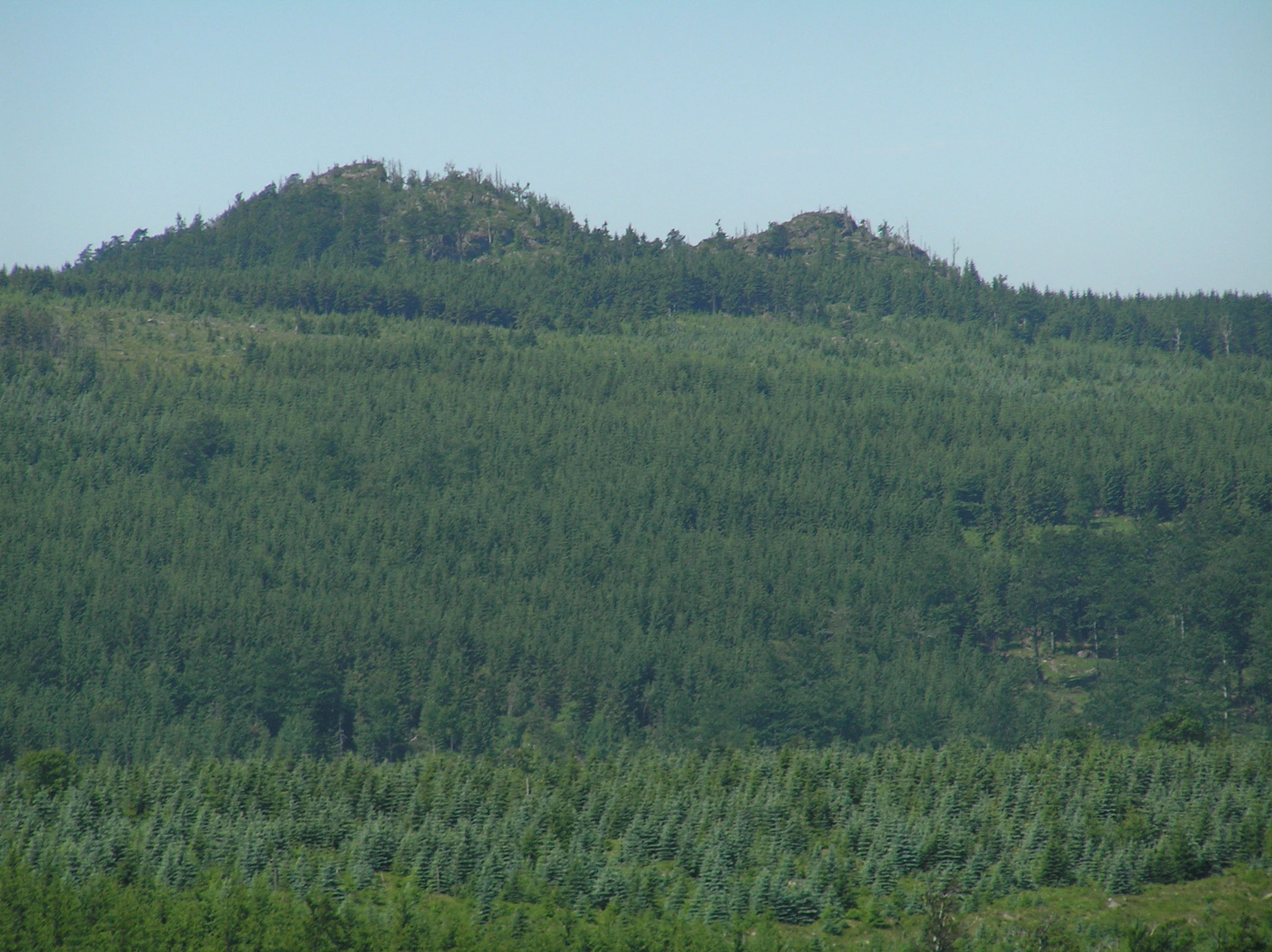
A distant view of rocky, forested mountain peaks under a clear sky, surrounded by vast green woodlands.
A view of the Ptaci kupy rock formations rising above the dense forests of the Jizera Mountains.

Ptačí kupy history and protected-area timeline

The name Ptací kupy itself preserves a piece of regional cultural history. It refers to the medieval practice known as čižba, a form of traditional bird trapping, because one of the Jizera catch-places was located on the very summit of this mountain.

Formal protection of the area began on 21 June 1960, when the Ministry of Education and Culture declared the site a state nature reserve under the name 'Ptací vrchy' (Bird Mountains), with the aim of safeguarding the local forests, flora, and landscape features. In 1965 the Czechoslovak Ministry of Culture renamed it the nature reserve 'Ptací kupy', and in 1992 the Ministry of the Environment of the Czech Republic reaffirmed its protected status.

The mountain's ecological history reflects both long-term human activity and twentieth-century industrial damage. Historically, silver fir (Abies alba) was a more prominent component of the primeval forests here, but it was gradually lost through past logging and competition from other species. Between the 1940s and 1980s, the surrounding Jizera Mountain forests, including this reserve, suffered severe damage from sulfur dioxide emissions and resulting acid rain associated with nearby German and Polish power plants. Emissions only fell below critical levels after 1991, when those plants' operations were substantially reduced. As a legacy of that period, the skeletons of dead spruces were left standing in the reserve and now serve as habitat for invertebrates and birds.

Restoration efforts have shaped the more recent history of the site. Between 1997 and 1998, the most valuable parts of the reserve were fenced against browsing ungulates and managed against the expansive grass Calamagrostis villosa, while new seedlings were planted to reinforce the beech forest. In 2003, tending cuts, additional plantings, and enlargement of the fenced area took place. By 2010, the recovery was judged sufficient that the protective fence was dismantled. Nearby, the small memorial known as Mützelův obrázek, erected in memory of forester Ferdinand Mützel, shot by armed poachers in August 1866, marks another layer of the site's relationship with people.

Ptačí kupy landscape and geographic character

The summit of Ptací kupy is a flat-topped mountain crowned by two coarse-grained granite outcrops, with a third formation on the steep northwestern slope and several smaller rock groups scattered through the reserve. These granite outcrops are characteristic of the broader Jizera Mountains geology, where weathering over geological time has produced distinctive frost-riven blocks, well-developed joints, and horizontal sheet-like jointing. A narrow gap between the two summit rocks carries the main ridge trail, allowing foot traffic to pass between the boulders and reach the panoramic viewpoint at the very top.

The reserve itself sits at elevations between roughly 900 and 1,008 meters within a wider forested landscape of continuous spruce and beech woodland typical of the range. The mountain is the northern spur of the Hejnice ridge, embedded in the Smědavská hornatina (Smědava highland). Although the reserve contains no permanent streams or standing water, the broader mountain drains into nearby tributaries including the Small and Great Štolpich, the Smědá, and the Lužická Nisa (Lusatian Neisse), with the wider catchment ultimately belonging to the Oder river basin.

From the summit viewpoint, the landscape opens out across multiple regions of northern Bohemia and into neighboring ranges. Visitors can see the Frýdlant region to the north, the Ještěd area to the west, the Kozákov ridge, the main mass of the Krkonoše (Giant Mountains), and the Lužické hory (Lusatian Mountains). The neighboring peaks of Holubník, Poledník, Ořešník, and Olivetská hora frame the immediate surroundings, each contributing to the ridgeline character of this part of the Jizera Mountains.
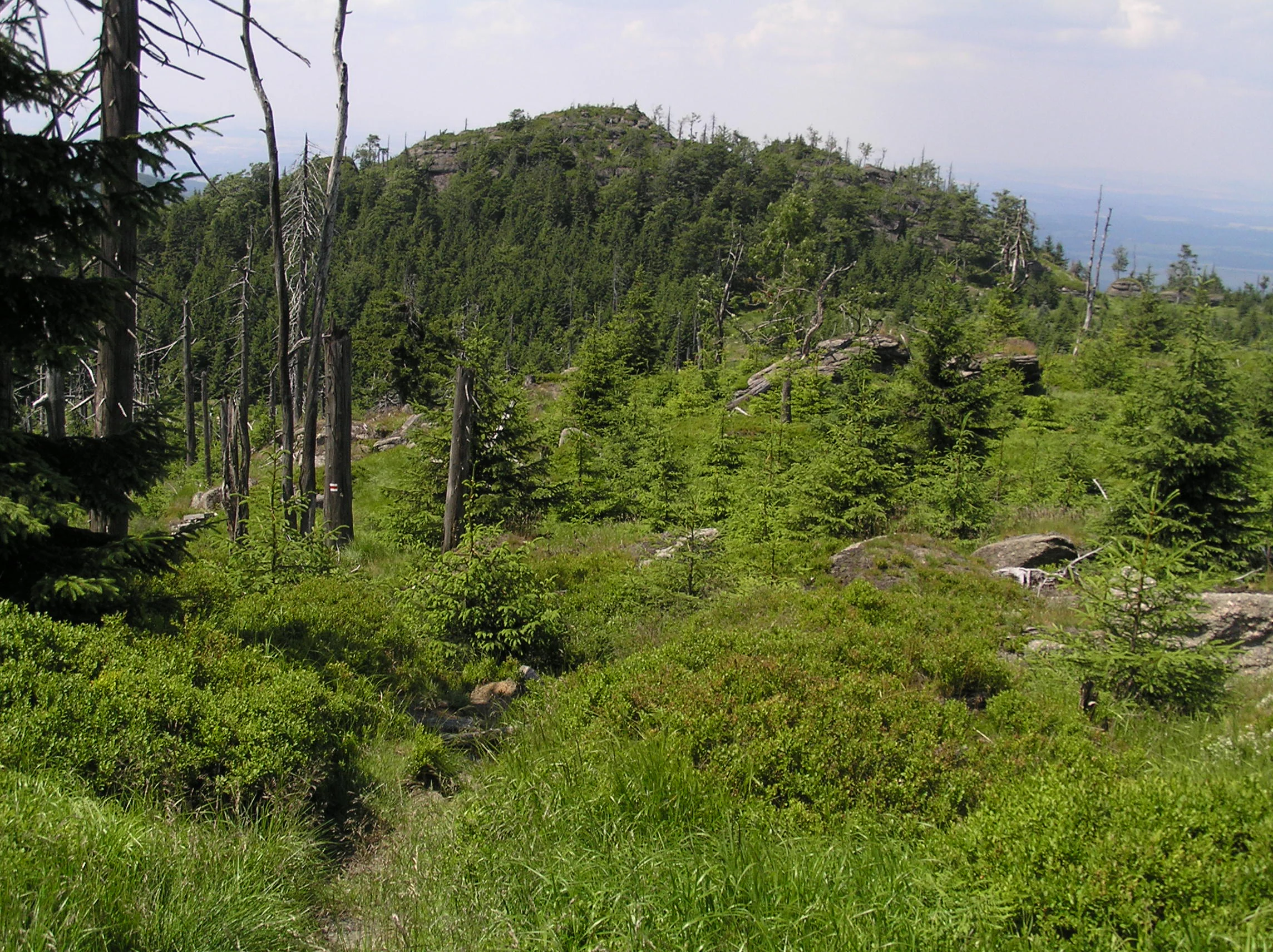
A mountainous landscape showing a forested summit with exposed granite rock formations and dead trees in the foreground, taken on a cloudy day.
A view of the Ptačí kupy summit, featuring granite rock formations and dense mountain forest.

Ptačí kupy ecosystems, habitats, and plant life

Ecologically, Ptací kupy is characterized by the overlap of geological rarity, high-elevation beech woodland, and the recovery dynamics of a damaged mountain forest ecosystem. The summit and upper slopes support mixed forest in which European beech (Fagus sylvatica), Norway spruce (Picea abies), and rowan (Sorbus aucuparia) share the canopy. The western flank below the summit carries the highest continuous acidophilic beech stand in the entire Jizerské hory, a particularly important feature given that this type of mountain beech forest is a primary reason for protection at both the Czech and European levels.

The soils are acidic, nutrient-poor, and shallow, often only a few decimeters deep over the granite bedrock, with regosol, iron-rich soil, and podzol mapped locally. The summit itself supports a litozem (lithosolic soil) only centimeters thick. Acidity here is driven both by the granite substrate and by the lingering effects of twentieth-century acid rain.

On the cleared northern slope, low vegetation dominated by bilberry (Vaccinium myrtillus) and cowberry (Vaccinium vitis-idaea) is typical, while a range of mountain herbs and ferns have been documented across the reserve, including Alpine coltsfoot (Homogyne alpina), whorled Solomon's seal (Polygonatum verticillatum), wood yellowgrass (Lysimachia nemorum), purple lettuce (Prenanthes purpurea), common cow-wheat (Melampyrum pratense), European goldenrod (Solidago virgaurea), chickweed wintergreen (Trientalis europaea), the expansive grass Calamagrostis villosa, and ferns such as Alpine lady fern (Athyrium distentifolium), beech fern (Phegopteris connectilis), and common oak fern (Gymnocarpium dryopteris). Although the number of plant species recorded at these oligotrophic, mountainous conditions remains modest, no comprehensive phytosociological survey has yet been completed for the site.
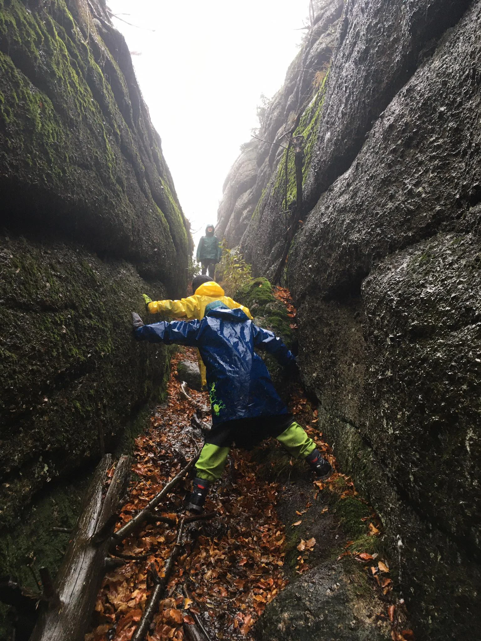
Two people in colorful rain jackets carefully climbing through a narrow, moss-covered granite chasm covered in fallen leaves.
Hikers navigating a narrow passage between granite rock formations in Ptačí kupy.

Ptačí kupy wildlife and species highlights

The animal life of Ptací kupy reflects both the natural character of the Jizera ridge forests and the recovery processes still underway after decades of pollution damage. Although direct wildlife sightings on the heavily visited summit rocks are uncommon, the surrounding cliffs and forests offer habitat for a notable range of species, in line with the site's inclusion in a Natura 2000 Bird Protection Area.

Birds of conservation interest include the tengmalm's owl (Aegolius funereus) and the peregrine falcon (Falco peregrinus), both of which are principal targets of protection in the Jizera Mountains Bird Protection Area. Common raven (Corvus corax) and Eurasian pygmy owl (Glaucidium passerinum), which nests in the cavities of old trees, are also associated with the area. Standing dead spruces left in place from the acid rain era now function as habitat for invertebrates and birds.

Invertebrates documented here include woodland ground beetles such as Carabus sylvestris, longhorn beetles like the musk beetle (Aromia moschata), and click beetles. Among Lepidoptera typical of local beech forest are the poplar admiral (Limenitis populi), the purple emperor (Apatura iris), the lesser purple emperor (Apatura ilia), and the tau emperor moth (Aglia tau). The boulder piles at the summit are also considered potential refuges for relict rove beetles (Staphylinidae) known from other Jizera peaks.

Amphibian fauna includes the fire salamander (Salamandra salamandra), the Alpine newt (Ichthyosaura alpestris), and the smooth newt (Lissotriton vulgaris). Reptiles present include the slow worm (Anguis fragilis), the common European adder (Vipera berus), and the viviparous lizard (Zootoca vivipara). Mammals across the mountain include typical forest ungulates and carnivores such as roe deer (Capreolus capreolus), red deer (Cervus elaphus), wild rabbit (Oryctolagus cuniculus), beech marten (Martes foina), pine marten (Martes martes), red fox (Vulpes vulpes), and wild boar (Sus scrofa), along with the Alpine shrew (Sorex alpinus), a species particularly associated with the higher elevations of the Jizerské hory.
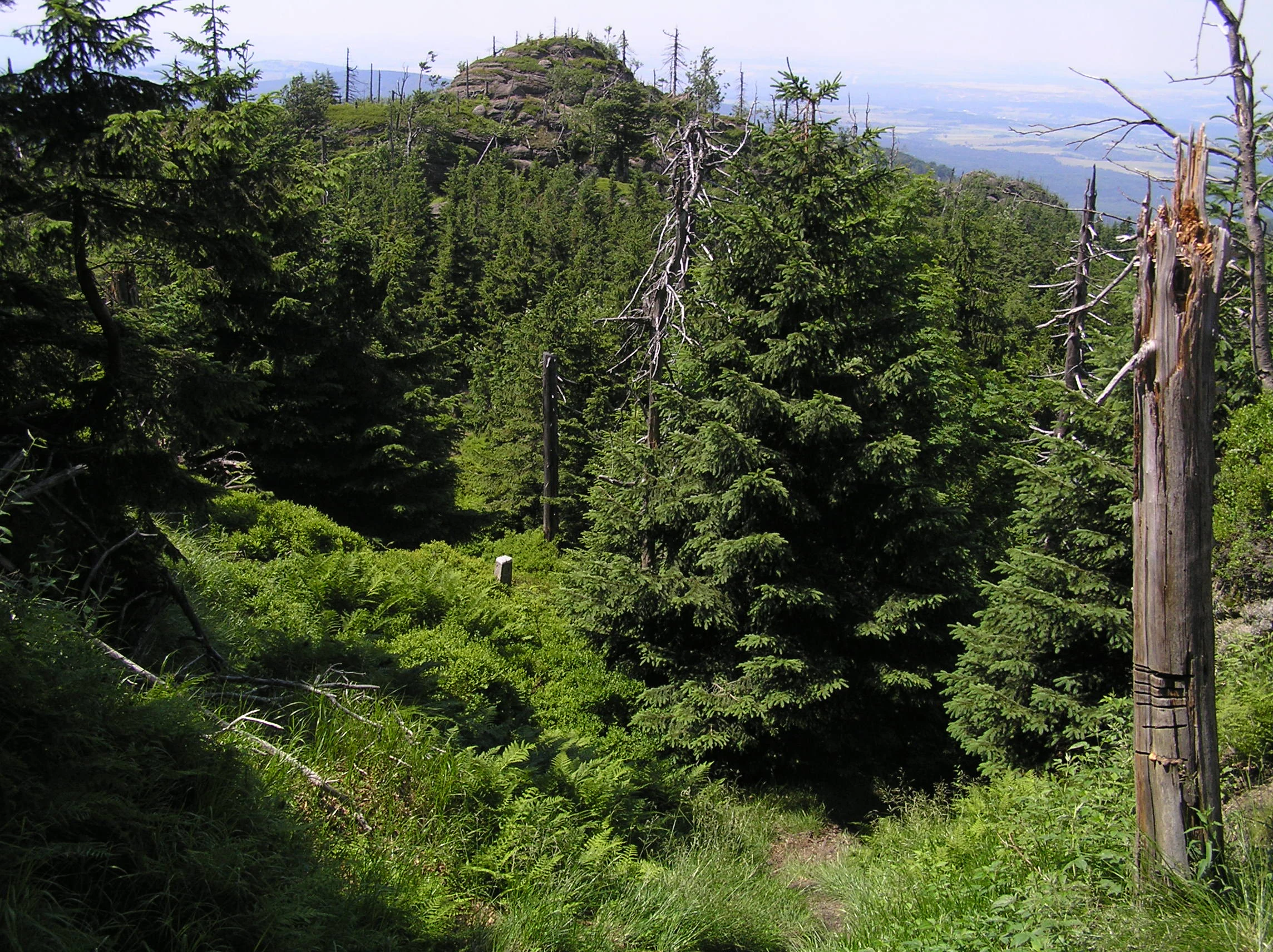
A view of a rocky, forested mountain peak in Ptačí kupy, showing dense coniferous trees, a prominent dead tree trunk in the foreground, and distant valley landscape under a clear sky.
Granite rock formations and mixed mountain forest at Ptačí kupy nature reserve in the Jizera Mountains.

Ptačí kupy conservation status and protection priorities

Ptací kupy sits within an unusually layered conservation framework for such a small site. It is part of the CHKO Jizerské hory (Jizera Mountains Protected Landscape Area), it lies within the broader Jizera Mountains Bird Protection Area, and most of its area belongs to the European Site of Community Importance 'Jizerskohorské bučiny' (Jizera Mountain Beech Forests). Both Natura 2000 designations underscore the European importance of its habitats, particularly the mountain acidophilic beech forest and the associated rock environments.

At the national level, the site has been protected as a nature reserve since 1960, first under the name Ptací vrchy, then renamed Ptací kupy in 1965, with reaffirmation by the Czech Ministry of the Environment in 1992. IUCN classifies it as a Category IV protected area (Habitat/Species Management Area). The reserve is administered by the Czech Agency for Nature Conservation and Landscape Protection (AOPK ČR) and is catalogued under code 346 in the central nature conservation register.

The principal subjects of protection are the mountain acidophilic stands of European beech (Fagus sylvatica), the broader flora, and the granite landscape features. Economic activities are excluded within the reserve, with management oriented toward minimizing anthropogenic influence and restoring natural processes. Past and ongoing interventions include fencing against ungulate browsing, mowing to suppress the expansive Calamagrostis villosa, replanting of beech, silver fir, and sycamore maple, and tending cuts. In 2003, new plantings and enlargement of the fenced area took place, and by 2010 the recovery was judged sufficient for the fence to be dismantled. Despite these successes, the forest is currently classified as cultural and near-natural rather than fully original, reflecting both past forestry and ongoing pressure from overabundant ungulates.

Ptačí kupy cultural meaning and human context

The cultural layer at Ptací kupy is unusually rich for a mountain summit. The name itself preserves a trace of the now-vanished medieval practice known as čižba, a traditional form of bird trapping practiced in the Jizera Mountains, where one of the historical 'catch-places' was located right on the mountaintop. This connection to a centuries-old regional pursuit of food and trade gives the otherwise straightforward topographic name a deeper folk-history dimension.

A more dramatic human narrative is commemorated by the small memorial known as Mützelův obrázek, located just off the marked trail on the northeastern side of the summit. It commemorates forester Ferdinand Mützel, who was shot by unknown armed poachers in August 1866, marking a dark episode in the long-running conflicts over wildlife and forest resources in the Jizera Mountains. Rather than being abstracted into a dry historical footnote, this event remains tied directly to the landscape through the painted memorial itself.

A more recent and quieter cultural practice is the tradition of summit books (vrcholové knihy), maintained on Ptací kupy as on other Jizera Mountains 'thousanders'. Hikers register their visits at the top, reflecting a long-running Bohemian mountain-visiting culture in which reaching and signing a summit is an established ritual, even at relatively remote peaks like this one.
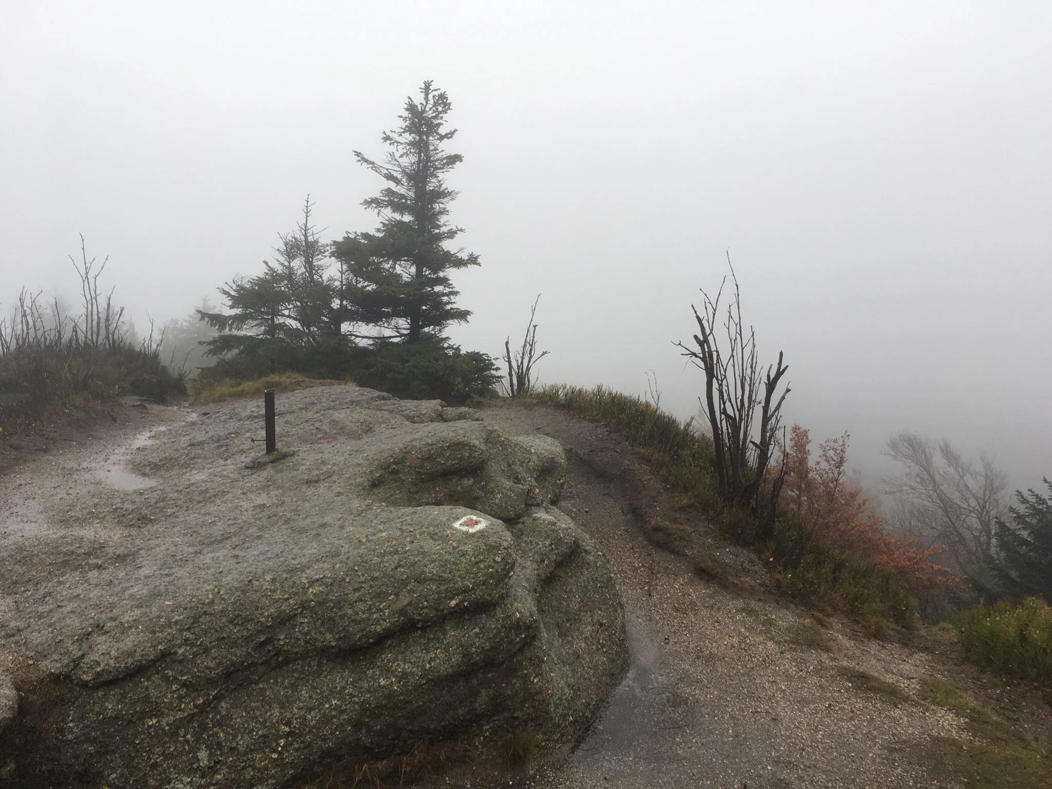
Granite rock formation at the mountain peak of Ptaci kupy, with pine trees and dense mountain fog in the background.
The summit of Ptaci kupy in the Jizera Mountains, characterized by its granite rock formations and dense mountain forest, often shrouded in fog.

Top sights and standout views in Ptačí kupy

The tight grouping of granite rock formations, high-elevation beech forest, and panoramic vista within a compact 11.76-hectare reserve gives Ptací kupy a concentrated and memorable character. Few sites combine so many of the Jizera Mountains' defining features in one place.

Other notable qualities include its place within the Natura 2000 network as part of both a Bird Protection Area and the Jizerskohorské bučiny Site of Community Importance, its mid-twentieth-century status as one of the early Czech nature reserves, and the visible recovery story told by the dead spruce skeletons retained from the acid rain era as wildlife habitat.
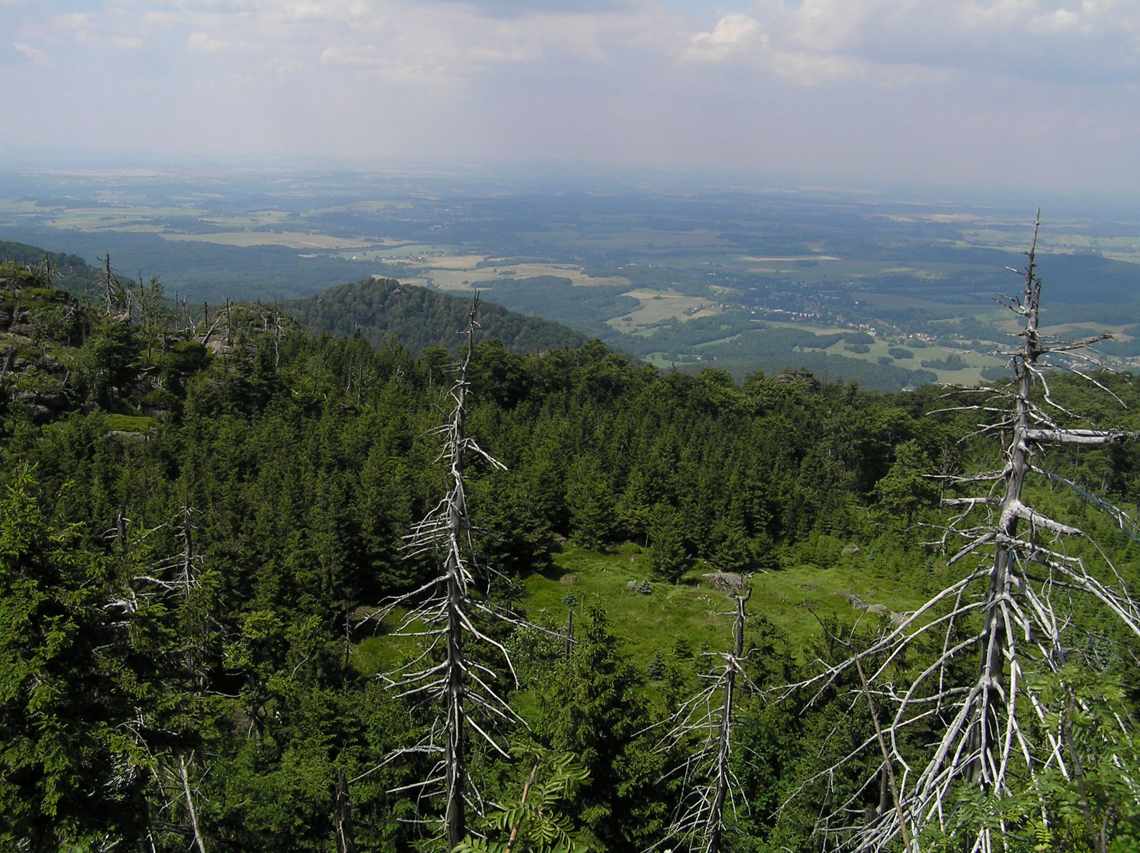
A high-angle view from a rocky mountain summit looking over a dense forest canopy and distant lowland plains.
A scenic overlook from the Ptačí kupy nature reserve, showing the surrounding Jizera Mountains and valley below.

Best time to visit Ptačí kupy

The character of a visit to Ptací kupy shifts noticeably with the seasons. Summer and early autumn are typically the most comfortable periods for hiking the marked ridge trail to the summit, when the viewpoints are accessible, the flowering and berry-rich ground layer is at its most visible, and the long views toward the Frýdlant region, Ještěd, the Kozákov ridge, the Krkonoše, and the Lužické hory are usually clearest under stable weather.

In winter, conditions on the exposed granite rocks and high ridge become more demanding, with strong winds, ice, and snow typical of elevations around 1,000 meters in the northern Jizerské hory. Because the steep, rocky terrain excludes both cyclists and skiers, the route remains a strictly pedestrian outing year-round and is best attempted in milder, calmer conditions regardless of season.

Monthly climate preview

Track representative monthly averages across thirty years of recorded weather data.

Ptačí Kupy Climate Normals, Long-Term Temperature and Precipitation Rhythms

Long-term NASA Power measurements reveal recorded temperature swings and daily precipitation rates across twelve distinct months at a representative coordinate. Accessing the complete monthly profile provides deeper comparative context on thermal shifts and moisture distribution.
Annual mean8 °C
-2 °C19 °C
Jan-2°
Feb-1°
Mar
Apr
May13°
Jun17°
Jul19°
Aug19°
Sep14°
Oct
Nov
Dec-1°
Warmest month
July

18.8 °C

Coolest month
January

-2.5 °C

Wettest month
July

3 mm/day

Driest month
April

1.4 mm/day

Park location guide

Geography guide, regional context, and park location map for Ptačí kupy

Ptačí kupy park geography, regions, and map view in Czechia

Understand where Ptačí kupy sits in Czechia through a broader geographic reading of the surrounding landscape, nearby location context, and its mapped position within the national park landscape.

How Ptačí kupy fits into Czechia

Czech Republic is a landlocked Central European country with a population of approximately 10.9 million people. The nation was established as an independent state on January 1, 1993, following the dissolution of Czechoslovakia. Its capital and largest city is Prague, with other major urban centers including Brno, Ostrava, Plzeň, and Liberec.

Wider geography shaping Ptačí kupy in Czechia

The Czech Republic is a landlocked country in Central Europe. It is bordered by Germany to the west, Austria to the south, Poland to the northeast, and Slovakia to the southeast. The landscape is predominantly hilly, with the territory covering 78,871 square kilometers.

Map view of Ptačí kupy

Use this park location map to pinpoint Ptačí kupy in Czechia, understand its exact geographic position, and read its mapped placement within the surrounding landscape more clearly.

Pigeon | © OpenStreetMap contributors

Location context for Ptačí kupy

Liberec Region

Explore detailed photography of high-elevation beech forests, rocky outcrops, and summit views.

Ptačí kupy Photos and Scenery: Visualizing Mountain Landscapes and Granite Formations

Visual records capture the distinctive granite rock formations and continuous acidophilic beech woodland defining the high-elevation terrain of Ptačí kupy. Examining these protected area photographs reveals the rugged topography, woodland habitats, and panoramic ridge character of the Jizera Mountains.

A distant view of rocky, forested mountain peaks under a clear sky, surrounded by vast green woodlands.

A view of an autumnal mountain forest with granite rock formations emerging from a misty landscape.

A mountainous landscape showing a forested summit with exposed granite rock formations and dead trees in the foreground, taken on a cloudy day.

Two people in colorful rain jackets carefully climbing through a narrow, moss-covered granite chasm covered in fallen leaves.

A view of a rocky, forested mountain peak in Ptačí kupy, showing dense coniferous trees, a prominent dead tree trunk in the foreground, and distant valley landscape under a clear sky.

A wide landscape view of the Ptačí kupy mountains covered in coniferous forest with rocky outcrops visible on the ridgeline, seen over a foreground of dense spruce trees.

Granite rock formation at the mountain peak of Ptaci kupy, with pine trees and dense mountain fog in the background.

A high-angle view from a rocky mountain summit looking over a dense forest canopy and distant lowland plains.

Park atlas

Compare nearby mountain summits, granite outcrops, and connected regional reserves

Parks Near Ptačí Kupy and Other Protected Areas in the Surrounding Region

Browsing other protected areas near Ptačí kupy reveals shared geological formations and high-elevation beech forests across the broader Jizera Mountains. Comparing adjacent ridgeline reserves provides deeper context on regional conservation landscapes and contiguous mountain habitats.
Natural monumentLiberecký kraj
About 4.6 km away#1 closest

East

Vlčí louka Natural Monument: Protected Bog Landscape in the Liberecký kraj Region

High-elevation peatland and mountain habitat geography

Vlčí louka serves as a prime example of a high-altitude raised bog located along the Smědavská hora ridge. This protected area supports a diverse suite of peatland plants and serves as a vital refuge for mountain birds. By studying its unique terrain, mapped boundaries, and position within the Jizera Mountains, users gain a deeper understanding of this specialized, elevated ecosystem in the Czech Republic.

Area
0.08 km²
Established
1965
IUCN
IV
Relief
Highland
A soft watercolor painting of rolling hills, grassy meadows, and coniferous trees set against a pale background.
Natural monumentCzechia
About 5 km away#2 closest

East

Na kneipě Natural Monument: Geography and Protected Mire Landscape in the Jizera Mountains

A rare summit peat bog and granite mountain plateau in Czechia.

Na kneipě serves as a preserved natural monument in the Czech Jizera Mountains, characterized by its rare summit mire and dense mountain pine coverage. Situated on a modest granite plateau, the area functions as a key hydrological hub that sustains surrounding upland habitats. This site provides essential context for understanding the high-elevation mire ecosystems and protected terrain found across northern Bohemia.

Established
1965
Relief
Mountain
Water
Minor water
Watercolor painting of a mountain range with spruce forest in the foreground on a white background.
Nature reserveLiberec Region
About 6.5 km away#3 closest

East

Prales Jizera Nature Reserve: Protected Mountain Geography and Summit Landscapes

Highland spruce forests and granite outcrops in the Liberec Region

Investigate the summit geomorphology of Prales Jizera, a vital protected area encompassing rare climax spruce forest and granite blockfields. This record provides detailed geographic context on the reserve's unique soil, hydrological watershed position, and its role as a landmark conservation site in the Jizera Mountains.

Area
0.936 km²
Established
1960
IUCN
IV
Relief
Mountain
Watercolor painting showing green forests, a valley, and distant mountains under a soft sky
National parkLiberec Region
About 16 km away#4 closest

East

Krkonoše National Park: Central European Alpine Protected Area and Map Context

Discover glacial landforms and unique ecosystems in the Giant Mountains.

Krkonoše National Park, situated in the Liberec Region, is a premier example of a protected alpine landscape in Central Europe. This page facilitates exploration of its significant glacial geography, including distinct cirques, rockfields, and valleys, providing vital context for understanding its protected area status. Engage with the mapped terrain and discover the unique ecological features that make this national park a cornerstone of conservation and geographic study within the Czech Republic.

Area
363.52 km²
Established
1963
IUCN
II
Visitors
12.1M annual
Watercolor illustration of a mountain range with green hills, pink and yellow sky, and sparse vegetation
National parkPoland
About 18 km away#5 closest

East

Karkonosze National Park: A Premier National Park in Poland's Giant Mountains

Discover alpine terrain and unique glacial landscapes.

Karkonosze National Park is a significant protected area in Poland, renowned for its dramatic alpine topography carved by ancient glaciers. As the highest range in the Polish Sudetes, it features striking U-shaped valleys, U-shaped glacial cirques, and diverse subalpine to alpine ecosystems. This national park provides a rich context for understanding Central European mountain geography and exploring its mapped protected boundaries.

IUCN
II
Relief
Mountain
Scope
Terrestrial
A minimalist watercolor illustration depicting rolling, layered mountain ridges in soft shades of green, yellow, and light pink against a white background.
National parkDolnośląskie Voivodeship
About 21 km away#6 closest

East

Karkonoski Park Narodowy: Mapping Protected Granite Peaks and Glacial Terrain in Poland

High-mountain landscapes in the Dolnośląskie Voivodeship

Trace the diverse geography of Karkonoski Park Narodowy, where granite blockfields and glacial cirques define the high-altitude terrain. This protected area represents one of Central Europe's most significant upland ecosystems, showcasing a vertical transition from dense forest to alpine tundra.

Area
59.51 km²
Established
1959
Visitors
2M annual
Relief
Mountain
A soft watercolor illustration of a rolling natural landscape with green trees, distant hills, and gentle colors on a white background.
Natural monumentLiberec Region
About 24 km away#7 closest

South

Na Vápenici Natural Monument: Geological Mapping and Protected Landscape Analysis

Calcareous outcrops and rare forest microhabitats in the Liberec Region

Na Vápenici represents a focused example of geological diversity, where a distinct limestone outcrop supports unique vegetation and paleontological richness. This natural monument provides a case study for understanding how isolated calcareous substrates contribute to the broader ecological health and terrain character of the Liberec Region.

Area
0.079 km²
Established
2008
IUCN
IV
Relief
Upland
A soft watercolor painting of a river flowing through a hilly, forested landscape with light green and pastel tones.
Nature reserveLower Silesian Voivodeship
About 31 km away#8 closest

Northeast

Ostoja nad Bobrem Nature Reserve and Bóbr River Valley Geographic Atlas

Protected Sudetes foothills landscape in Poland

Ostoja nad Bobrem represents a significant protected area within the Lower Silesian Voivodeship, characterized by its winding river corridor and hilly topography. The reserve supports a range of habitats including rare orchid-rich grasslands and dense slope forests. This atlas entry provides a detailed look at the geographic distribution and ecological importance of this essential Polish nature reserve.

Area
153.73 km²
Established
2009
Relief
Upland
Climate
Temperate

Common questions about visiting, size, designation, and location context for Ptačí kupy

Ptačí kupy FAQs for park facts, access, geography, and protected area context

Find quick answers about Ptačí kupy, including protected-area facts, park geography, trail and visitor context, and how the park fits into its surrounding country and regional landscape.
MoriAtlas Explorer

Continue Your Protected Areas Search Across the Global Atlas

Deepen your exploration by continuing the structured search for national parks and protected areas worldwide. Utilize the comprehensive filtering capabilities to compare different conservation landscapes and refine your understanding of global park geography. Discover more about the distribution and characteristics of protected natural areas.

Global natural geography