Mori Atlas logo
National parkPuracé National Natural Park

Discover the mapped boundaries and regional setting of this important Colombian national park.

Puracé National Natural Park: Protected Landscape & Geographic Context in Cauca Department

(Parque Nacional Natural Puracé)

Puracé National Natural Park stands as a significant protected natural area within the Cauca Department of Colombia. This page provides an atlas-focused exploration of the park's protected landscape, detailing its geographic context and mapped boundaries. Understand how Puracé National Natural Park contributes to the region's conservation efforts and discover its place within Colombia's broader network of natural landscapes.

volcanic landscapeAndean protected areaparamo ecosystemnational parkhigh-altitude wildernessriver source

Puracé National Natural Park

National park

Park overview

Structured park overview, official facts, and landscape profile for Puracé National Natural Park

Puracé National Natural Park park facts, protected area profile, and essential visitor context
Review the core facts for Puracé National Natural Park, including designation, size, terrain, visitor scale, habitats, and operating context in one park-focused overview.

About Puracé National Natural Park

Puracé National Natural Park represents a remarkable convergence of geological forces, ecological diversity, and hydrological significance in the Colombian Andes. The park's central feature, the active Puracé volcano, has shaped both the physical landscape and the ecological character of the region over millions of years. This stratovolcano, standing at 4,580 meters, forms part of a volcanic chain that includes several other notable peaks, creating a dramatic high-altitude environment characterized by crater lakes, volcanic ridges, and the distinctive Paletará valley at its base. The geological activity continues to influence the park, with sulfur vents and hot springs providing evidence of ongoing volcanic processes beneath the surface. Beyond its volcanic identity, the park serves a critical function in Colombia's hydrological system, with four of the country's most important rivers originating within its boundaries. The Magdalena River alone flows northward to become Colombia's principal waterway, while the Cauca, Japurá, and Patía rivers each drain different regions of the country. This watershed function gives the park significance far beyond its immediate boundaries, connecting it to the water security and ecological health of much of Colombia. The park can be accessed from Popayán via a well-maintained 44-kilometer road leading to the town of Puracé at the volcano's base, with further access to recreational areas including Pilimbalá in the northern sector.

Quick facts and research context for Puracé National Natural Park

Puracé National Natural Park spans approximately 830 square kilometers in the Andean highlands of Cauca Department, Colombia. The park centers on the active Puracé volcano at 4,580 meters, surrounded by higher peaks including Azúcar at 5,000 meters and Coconuco at 4,600 meters. The protected area was established in 1961 and is governed by Colombia's National System of Protected Areas (SINAP). The region experiences high-altitude climate with daytime temperatures between 14 and 16°C and nighttime temperatures dropping below freezing, particularly above 3,000 meters. Annual rainfall averages 2,500 millimeters. The park holds IUCN category II protected area status as a national park.

Park context

Deeper park guide and search-rich context for Puracé National Natural Park

Puracé National Natural Park history, landscape, wildlife, and travel context
Explore Puracé National Natural Park through its history, landscape character, ecosystems, wildlife, conservation priorities, cultural context, and seasonal travel timing in a structured park guide built for atlas discovery and search intent.

Why Puracé National Natural Park stands out

Puracé National Natural Park is best known for its dramatic volcanic landscape centered on one of Colombia's most active volcanoes, which has created a visually striking high-altitude environment of craters, geothermal features, and volcanic valleys. The park's exceptional hydrological significance, as the source of four major Colombian rivers, distinguishes it from most other protected areas in the country. The Paletará valley at the foot of the volcano offers particularly dramatic scenery. The park is also renowned for its remarkable biodiversity in a relatively small area, including populations of spectacled bears, mountain tapirs, Andean condors, and diverse orchid species, all set within a landscape where paramo ecosystems meet volcanic terrain.

Puracé National Natural Park history and protected-area timeline

Puracé National Natural Park was established in 1961, making it the first national park created in the Cauca Department of Colombia. Its creation reflected a growing recognition in mid-20th century Colombia of the need to protect unique natural areas that combined geological significance, ecological value, and watershed function. The selection of this volcanic landscape for protection acknowledged both the scientific importance of the active volcano system and the ecological richness of the high-altitude Andean environments it encompassed. During the turbulent decades that followed, the park faced significant challenges from the presence of Revolutionary Armed Forces of Colombia (FARC) guerrillas, who established base camps within the protected area during the 1990s. This period of instability impacted both park management and visitor access. Following the launch of a major military campaign against guerrilla movements by President Álvaro Uribe in 2002, the security situation in the region improved considerably, allowing for more effective park management and renewed access for visitors and researchers. Today, the park is managed under Colombia's National System of Protected Areas (SINAP), which coordinates conservation efforts across the country's protected landscape.

Puracé National Natural Park landscape and geographic character

The landscape of Puracé National Natural Park is defined by its dramatic volcanic geology and high-altitude positioning within the Cordillera Central range. The central volcano Puracé rises to 4,580 meters, its slopes and crater area forming the visual anchor of the park. Surrounding this active peak are higher volcanic formations including Azúcar at 5,000 meters and Coconuco at 4,600 meters, along with four additional volcanoes ranging between 4,400 and 4,500 meters in elevation. The Paletará valley, located at the foot of Puracé, provides a particularly striking landscape feature where volcanic soils and glacial meltwater have created a unique valley environment. The terrain varies dramatically with elevation, from the lower forested slopes through paramo zones characterized by pajonal grasses and dwarf vegetation to the rocky, often snow-capped summit zones of the highest peaks. The volcanic origin of the landscape is evident in the rocky terrain, the presence of sulfur vents, and the characteristic dark soils that distinguish this area from the surrounding Andean landscapes.

Puracé National Natural Park ecosystems, habitats, and plant life

The ecological systems within Puracé National Natural Park reflect the park's exceptional altitudinal range and the transitional nature of its position within the Andean biogeographic region. The lower elevation forests support diverse tree species including the nationally threatened Colombian Pine (Podocarpus oleifolius), Andean Oak (Quercus humboldtii), and the iconic Wax palm tree (Ceroxylon quindiuense), Colombia's national tree. These forests host impressive biodiversity including four primate species: woolly monkeys, howler monkeys, gray-bellied night monkeys, and tufted capuchins. At higher elevations, the park transitions into paramo ecosystems characterized by specialized vegetation adapted to the harsh conditions of near-freezing temperatures, intense UV radiation, and seasonal waterlogging. The park's botanical richness is particularly evident in its orchid diversity, with over 200 species documented within the park's boundaries. This orchid wealth represents one of the highest concentrations of orchid species in any protected area in Colombia.

Puracé National Natural Park wildlife and species highlights

The wildlife communities within Puracé National Natural Park reflect the park's diverse habitats ranging from cloud forests to paramo zones. The park supports over 160 bird species, with hummingbirds, ducks, and birds of prey representing the most diverse and commonly observed groups. The Andean condor holds particular significance, with the San Diego Zoo contributing to reintroduction efforts for this species during the 1990s. Several mammal species of conservation concern inhabit the park, including the spectacled bear (Tremarctos ornatus), the only bear species native to South America, which has adapted to the high-altitude Andean environment. The mountain tapir (Tapirus pinchaque), the smallest of the world's four tapir species and found only in the northern Andes, persists in the park's forest habitats. Additional mammals include the cougar (Puma concolor) and the pudú (Pudu puda), one of the world's smallest deer species. The primate communities in the lower elevation forests add further diversity to the park's wildlife profile.

Puracé National Natural Park conservation status and protection priorities

Puracé National Natural Park holds IUCN category II protected area status as a national park, reflecting its significant conservation value at both national and international levels. The park's conservation significance stems from multiple factors: its role as a critical watershed providing water to four major river systems serving millions of Colombians, its protection of significant biodiversity including several nationally threatened species, and its preservation of unique volcanic and high-altitude Andean ecosystems. The presence of multiple threatened tree species including the Colombian Pine, Andean Oak, and Wax palm tree highlights the importance of the park's forest conservation efforts. Similarly, the protection of habitat for species such as the spectacled bear, mountain tapir, and Andean condor contributes to broader conservation goals for these species that have suffered significant range reductions throughout their historic distributions. The park's management under SINAP integrates conservation objectives with sustainable use considerations, recognizing the needs of indigenous communities who have historically inhabited the area.

Puracé National Natural Park cultural meaning and human context

Puracé National Natural Park holds significant cultural value beyond its ecological and geological importance. The park's territory serves as an indigenous reservation for the Coconuco ethnic group, whose presence in the Pilimbalá sector of the park predates the formal establishment of the protected area. The Coconuco people maintain a living cultural connection to the landscape, offering visitors lodging and traditional food that provides economic benefits while preserving cultural traditions. An additional Guambiano settlement exists within the park boundaries, reflecting the broader indigenous presence in this region of the Colombian Andes. This indigenous context adds layers of cultural meaning to the landscape, connecting the volcanic terrain and high-altitude environments to traditional land use practices, spiritual beliefs, and community identity. The relationship between the indigenous communities and the park's management represents an important model for integrating cultural preservation with conservation objectives.

Top sights and standout views in Puracé National Natural Park

Puracé National Natural Park offers several standout features that distinguish it within Colombia's protected area system. The active Puracé volcano itself represents a dramatic natural feature, one of the most active in Colombia, providing visitors with opportunities to witness volcanic activity in a relatively accessible high-altitude setting. The park's function as the source of four major Colombian rivers gives it watershed significance of national importance. The dramatic Paletará valley at the volcano's base offers a distinctive landscape feature. The remarkable orchid diversity, with over 200 species, represents botanical significance of international interest. Wildlife viewing opportunities include the chance to observe spectacled bears, mountain tapirs, Andean condors, and diverse primate species. The cultural dimension of the park, with indigenous Coconuco communities offering traditional hospitality in the Pilimbalá sector, provides a unique opportunity to experience Andean indigenous culture within a protected area context.

Best time to visit Puracé National Natural Park

The best time to visit Puracé National Natural Park depends on the experience sought, though the high-altitude environment imposes significant seasonal constraints. The park experiences a subpolar oceanic climate with temperatures ranging from 14-16°C during the day to below freezing at night, particularly at elevations above 3,000 meters where frost occurs frequently, and above 4,200 meters where frost occurs almost daily. Annual rainfall averages 2,500 millimeters, with precipitation generally decreasing at higher elevations. The dry season typically offers more stable conditions for hiking and wildlife viewing, though visitors should be prepared for cold conditions regardless of season. The rainy season, from April to November, brings higher precipitation and potentially foggy conditions that may limit visibility from volcanic viewpoints. Visitors planning to hike to the crater should allow approximately 3.5 hours from Pilimbalá under good conditions, or 1.5-2 hours if accessing via the former military base route.

Park location guide

Geography guide, regional context, and park location map for Puracé National Natural Park

Puracé National Natural Park park geography, regions, and map view in Colombia
Understand where Puracé National Natural Park sits in Colombia through a broader geographic reading of the surrounding landscape, nearby location context, and its mapped position within the national park landscape.

How Puracé National Natural Park fits into Colombia

Colombia is a presidential republic located in the northern part of South America. It spans approximately 1.14 million km² and has a population of around 52 million. The country features the Andes mountain range, extensive Amazon rainforest, and coastal regions on both the Caribbean and Pacific. Spanish is the official language, and Bogotá serves as the capital and largest city.

Wider geography shaping Puracé National Natural Park in Colombia

Colombia is located in the northwestern part of South America, bordering the Caribbean Sea to the north and the Pacific Ocean to the west. Its mainland neighbors are Venezuela to the east, Brazil to the southeast, Peru and Ecuador to the south and southwest, and Panama to the northwest. The terrain is diverse, featuring the Andes mountain range in the west, Amazon rainforest in the south and east, and coastal plains along both oceans.

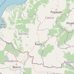
Map view of Puracé National Natural Park

Use this park location map to pinpoint Puracé National Natural Park in Colombia, understand its exact geographic position, and read its mapped placement within the surrounding landscape more clearly.

Pigeon | © OpenStreetMap contributors

Location context for Puracé National Natural Park

Cauca Department
Park atlas

Trace the Protected Landscapes and Volcanic Terrain Near Puracé in Colombia's Central Andes

Explore National Parks and Protected Areas Near Puracé National Natural Park in the Colombian Andes
Browse national parks and protected areas geographically close to Puracé National Natural Park, a high-altitude wilderness known for its active volcano and vital river sources in the Colombian Andes. Continue exploring the region's diverse paramo, cloud forest, and volcanic landscapes by comparing adjacent protected areas, gaining deeper context for the broader Andean geography.
National parkNariño Department

Doña Juana-Cascabel Volcanic Complex National Natural Park: National Park with Mapped Protected Landscape

Explore its volcanic terrain and geographic context in Nariño Department.

Doña Juana-Cascabel Volcanic Complex National Natural Park is a designated National Park offering rich opportunities for geographic exploration. Situated within Nariño Department, this protected landscape provides a unique lens through which to study regional natural features and mapped conservation boundaries. Its presence within Colombia's protected areas network makes it a key point of reference for understanding national park geography and landscape context.

Area
0.267 km²
Established
2007
IUCN
II
Relief
Mountain
National parkCauca Department

Munchique National Natural Park: National Park with Key Protected Landscape Features

Explore mapped geography and protected area context.

Munchique National Natural Park is a designated National Park offering a distinct protected landscape within Colombia's Cauca Department. This page provides essential context for understanding its geographic footprint, regional setting, and its significance as a mapped natural area. Dive into the atlas details and explore the unique geography that defines this protected entity.

Area
440 km²
Established
1977
IUCN
II
Relief
Mountain
National parkColombia

Serranía de Los Churumbelos Auka-Wasi National Natural Park: Colombia's Protected Landscape Atlas

Mapped national park boundaries and regional geography.

Understand Serranía de Los Churumbelos Auka-Wasi National Natural Park through its geographic context and protected landscape features. This atlas view highlights the park's mapped boundaries and its significance within Colombia's natural geography, offering detailed insights into its protected status and regional terrain.

Area
562 km²
Established
2007
IUCN
II
Relief
Mountain
Watercolor painting of a lake with green hills and trees in the background
Protected areaNariño

La Corota Island Flora Sanctuary: A Unique Protected Area within Colombia's Nariño Region

Explore its Andean cloud forest landscape and mapped island geography.

La Corota Island Flora Sanctuary is a critical protected area in Nariño, Colombia, celebrated for its distinctive status as the country's only lake island ecosystem supporting old-growth Andean cloud forest. This compact sanctuary provides a unique landscape context, safeguarding endemic plant species and diverse birdlife within its mapped boundaries. Its presence within Laguna de la Cocha highlights a special convergence of wetland and forest geography, offering insights for atlas exploration of protected lands.

Area
0.152 km²
Established
1977
IUCN
II
Visitors
28K annual
Watercolor painting of green hills, trees, and distant mountains under a light sky
National parkValle del Cauca Department

Farallones de Cali National Park: Protected Landscape and Geographic Atlas

Explore mapped boundaries and regional context.

Farallones de Cali National Park offers a distinct protected landscape within Valle del Cauca Department. This page provides atlas-level detail on its geographic scope and mapped features, crucial for understanding its regional context. Dive into the protected-area specifics to grasp the natural terrain and conservation landscape that defines this significant Colombian national park.

Area
1,500 km²
Established
1968
IUCN
II
Relief
Mountain
Watercolor illustration of a mountain range with a lake in the foreground, green fields, and a colorful sky
Protected areaColombia

Galeras Protected Area: Exploring Colombia's Mapped Natural Landscapes

Discover the geography and protected terrain of Galeras.

The Galeras protected area in Colombia offers a distinct opportunity for geographic exploration, focusing on its defined boundaries and the natural landscape it encompasses. This resource details the park's setting within the Colombian geography, providing a map-centric view of its protected status. Understanding Galeras contributes to a broader appreciation of protected lands across South America and their unique terrain.

Relief
Mountain
Climate
Alpine
Access
Highly restricted
National parkValle del Cauca Department

Uramba Bahía Málaga National Natural Park: National Park Protected Landscape and Geography

Explore mapped natural terrain and protected boundaries.

Gain a detailed atlas understanding of Uramba Bahía Málaga National Natural Park, a designated national park in Colombia's Valle del Cauca Department. This page details its protected landscape features and geographic setting, offering insights into its mapped boundaries and regional context for dedicated geographic exploration.

Area
471 km²
Established
2010
IUCN
II
Climate
Tropical
National parkColombia

Los Nevados National Natural Park: Colombia's National Park and Protected Landscape

Detailed map context and protected land geography.

Los Nevados National Natural Park serves as a key protected area within Colombia, offering rich opportunities for geographic discovery. This page details the park's mapped boundaries and its contribution to the broader atlas of South American protected lands. Explore the unique landscape character and regional geographic significance that define Los Nevados National Natural Park as a vital natural reserve.

Area
583 km²
Established
1973
IUCN
II
Visitors
39.9K annual

Common questions about visiting, size, designation, and location context for Puracé National Natural Park

Puracé National Natural Park FAQs for park facts, access, geography, and protected area context
Find quick answers about Puracé National Natural Park, including protected-area facts, park geography, trail and visitor context, and how the park fits into its surrounding country and regional landscape.
MoriAtlas Explorer

Continue Your Protected Areas Search Across the Global Atlas

Deepen your exploration by continuing the structured search for national parks and protected areas worldwide. Utilize the comprehensive filtering capabilities to compare different conservation landscapes and refine your understanding of global park geography. Discover more about the distribution and characteristics of protected natural areas.

Global natural geography