Mori Atlas logo
National parkRago National Park

Discover the rugged terrain, glacial lakes, and transboundary significance of this unique Scandinavian protected landscape.

Rago National Park: An Atlas of Protected Mountain Wilderness in Nordland, Norway

Rago National Park, a designated national park in Norway's Nordland region, offers a profound geographic discovery into a remote and challenging mountain wilderness. Established to protect its unique Arctic-alpine terrain, the park's boundaries encompass steep ridges, alpine lakes, and glacial features. As part of one of Europe's largest contiguous protected areas, Rago National Park is key to understanding the broader conservation landscape of northern Scandinavia and its regional geography.

National ParksNorwayNordlandMountain WildernessTransboundary Protected AreasAlpine Environments
Digital illustration of a winding river through a mountainous valley with green forests and rocky cliffs

Rago National Park

National park

Park overview

Structured park overview, official facts, and landscape profile for Rago National Park

Rago National Park park facts, protected area profile, and essential visitor context
Review the core facts for Rago National Park, including designation, size, terrain, visitor scale, habitats, and operating context in one park-focused overview.

About Rago National Park

Rago National Park is located in the mountainous interior of Nordland county, a region characterized by deep valleys, steep ridges, and vast wilderness areas. The park lies immediately east of the European route E6 highway, making it accessible from the nearby town of Fauske while still maintaining a sense of remoteness and isolation. The terrain consists primarily of alpine and sub-alpine landscapes with limited vegetation due to the harsh climate and nutrient-poor soils that characterize much of northern Norway's interior.The park's eastern boundary follows the border with Sweden, connecting directly to Padjelanta National Park on the Swedish side. This transboundary relationship is significant not only for ecological continuity but also for creating one of the largest protectedarea complexes in Europe. The combined Norwegian and Swedish protected lands represent a substantial commitment to wilderness preservation across international boundaries.Lake Storskogvatnet and Lake Litlverivatnet are notable inland water bodies within the park, while the southeastern region contains several glaciers that contribute to the landscape's dynamic character. The park's name derives from the Sami language, specifically the term Rákkok, which descriptively captures the challenging nature of moving through this terrain. This Sami etymology connects the park to the indigenous heritage of the region and reflects the historical relationship between local communities and this demanding mountain environment.

Quick facts and research context for Rago National Park

Rago National Park occupies 171 square kilometers in Nordland county, Norway, established in 1971. The park borders Sweden's Padjelanta National Park, forming part of a vast transboundary protected area spanning approximately 5,400 square kilometers. The landscape features several lakes including Storskogvatnet and Litlverivatnet, along with glaciers in the southeastern sector. The park's ecology is shaped by poor soils and harsh climatic conditions, resulting in limited plant diversity with pine-dominated woodlands and alpine flora. Wildlife includes moose, semi-domesticated reindeer, wolverines, willow grouse, and golden eagles.

Park context

Deeper park guide and search-rich context for Rago National Park

Rago National Park history, landscape, wildlife, and travel context
Explore Rago National Park through its history, landscape character, ecosystems, wildlife, conservation priorities, cultural context, and seasonal travel timing in a structured park guide built for atlas discovery and search intent.

Why Rago National Park stands out

Rago National Park is best known for its transboundary significance as part of a vast Scandinavian protected-area complex spanning the Norway-Sweden border. The park protects a remote, rugged mountain landscape that exemplifies the challenging Arctic-alpine terrain of northern Norway. Its designation as part of one of Europe's largest contiguous protected areas, combined with the Sami heritage reflected in its name meaning difficult and impassable mountain region, gives the park particular significance for conservation and regional identity.

Mountainous landscape with turquoise lake, snow-covered peaks, and rocky foreground under a partly cloudy sky
Panoramic view of turquoise lakes and snow-capped mountains in Rago National Park

Rago National Park history and protected-area timeline

Rago National Park was formally established on 22 January 1971 as part of Norway's expanding network of protected areas during the mid-twentieth century. The park's creation reflected growing recognition of the need to preserve Norway's remaining wilderness landscapes and unique ecological communities. At the time of establishment, the national park system in Norway was being developed to protect representative examples of the country's diverse landscapes, from coastal areas to mountain regions.The park's designation also acknowledged the significance of the transboundary landscape, and subsequent planning has considered the connected protected areas on the Swedish side. Management of the park falls under the Norwegian Directorate for Nature Management, which oversees conservation implementation and policy for protected areas throughout the country. The establishment of Rago National Park contributed to Norway's commitments to international conservation efforts and helped secure protection for a distinctive mountain ecosystem that might otherwise have faced development pressures.

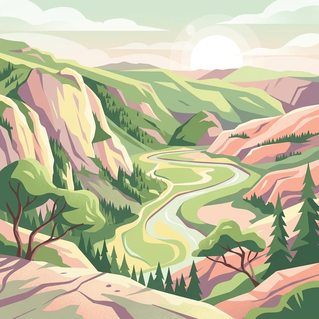
Rago National Park landscape and geographic character

The landscape of Rago National Park is defined by its location in the mountainous interior of Nordland, a region known for its dramatic topography and extensive wilderness. The terrain consists of alpine mountains with steep-sided valleys, exposed ridges, and open plateaus typical of northern Scandinavian mountain terrain. The park's elevation range supports a transition from sub-alpine woodland in the lower valleys to alpine and nival zones on the higher ground.Lake Storskogvatnet and Lake Litlverivatnet are significant freshwater features within the park, their surfaces reflecting the surrounding mountain scenery. The southeastern portion of the park contains several glaciers, remnants of the more extensive glacial coverage that shaped this landscape during the last ice age. These ice masses continue to influence local hydrology and contribute to the character of the park's eastern sector.The overall impression is one of remote, austere beauty where exposed bedrock, thin soils, and harsh climatic conditions combine to create a challenging environment. The landscape lacks the lush vegetation found in more coastal areas of Norway, instead presenting a more sparse and elemental character that emphasizes the sense of wilderness that the park was established to protect.

Rocky mountain landscape with patches of snow on peaks, a lake in the valley, and grassy areas
Mountainous landscape of Rago National Park with rocky terrain and a small lake

Rago National Park ecosystems, habitats, and plant life

The natural environment of Rago National Park is characterized by limited species diversity due to the harsh climate, poor soils, and northern latitude. The park's vegetation consists primarily of pine-dominated woodlands in the lower elevations, with more extensive alpine vegetation occurring among the trees and in areas where soil conditions permit. The transition zone between forest and open alpine terrain supports various alpine plant species adapted to the short growing season and cold temperatures.The park does not support the rich biodiversity found in more temperate regions of Norway, but the species present are adapted to survive in these challenging conditions. The sparse woodland and open terrain create a distinctive northern landscape where the effects of climate and soil infertility are clearly visible in the vegetation patterns. This limited productivity is typical of northern mountain environments and reflects the ecological constraints that shape life in these latitudes.

Rago National Park wildlife and species highlights

Wildlife in Rago National Park reflects the northern and alpine character of the landscape. Moose are present in the park and represent one of the larger mammalian species found in this region. Semi-domesticated reindeer also occur within the park boundaries, reflecting the traditional reindeer husbandry practices of Sami communities in northern Scandinavia. The presence of wolverines indicates the park supports predatory species capable of surviving in this harsh environment.Willow grouse and golden eagles are the most frequently observed bird species in the park. The willow grouse is well adapted to the alpine and boreal environments of northern Norway, while the golden eagle occupies the open terrain and preys on the available prey species. The overall wildlife community is not diverse in terms of species numbers, but the species present are characteristic of northern Scandinavian mountain ecosystems and contribute to the park's ecological significance.

Rago National Park conservation status and protection priorities

Rago National Park contributes to conservation of northern Scandinavian mountain ecosystems as part of a transboundary protected-area complex of international significance. The park's connection to Sweden's Padjelanta National Park and the larger network of protected areas creates an ecological corridor that supports wildlife movement and maintains ecological processes across an extensive landscape. This combined protected area of approximately 5,400 square kilometers represents one of the most significant wilderness protection initiatives in Europe.The park protects a representative example of northern Norwegian mountain terrain and the ecological communities that have adapted to these challenging conditions. While biodiversity is limited compared to more temperate regions, the conservation of this landscape preserves important ecological processes and habitat for species adapted to northern conditions. The transboundary protected-area network demonstrates international cooperation in environmental protection and contributes to broader conservation goals for European mountain ecosystems.

Rago National Park cultural meaning and human context

The name Rago National Park derives from the Sami language, specifically the term Rákkok, which means difficult and impassable mountain region. This etymology reflects both the physical challenges of traversing this terrain and the historical presence of Sami communities in this area of northern Norway. The Sami people have traditionally inhabited the northern regions of Norway, Sweden, Finland, and Russia, and their cultural connection to the landscape is reflected in place names throughout the region.The use of a Sami term for the park's name acknowledges the indigenous heritage of the region and the historical relationship between local communities and these mountain lands. While the park's primary purpose is nature conservation, the retention of Sami naming preserves an important cultural dimension of the landscape's identity.

Top sights and standout views in Rago National Park

Rago National Park stands as part of one of Europe's largest transboundary protected-area complexes, spanning the Norway-Sweden border with adjacent Swedish parks to create a vast wilderness corridor of approximately 5,400 square kilometers. The park protects remote mountain terrain with glacial features, alpine lakes, and pine-dominated woodlands in a landscape that embodies the challenging character reflected in its Sami-derived name meaning difficult and impassable mountain region. The park's establishment in 1971 contributed to the preservation of representative northern Scandinavian mountain ecosystems and demonstrates successful international cooperation in conservation across national boundaries.

Best time to visit Rago National Park

The optimal season for visiting Rago National Park aligns with the Norwegian summer months of June through August, when daylight hours are longest and temperatures are most moderate for outdoor exploration. During this period, snow has melted from the lower trails and alpine zones become accessible for hiking. The park's northern latitude means summer days are extended, providing more time for activities. Winter visits are challenging due to harsh conditions, limited daylight, and snow cover that restricts access to most of the park. The shoulder seasons of spring and autumn offer transitional conditions but may present variable weather and reduced services. Visitors should prepare for the northern continental climate regardless of season, with appropriate clothing and awareness that conditions can change rapidly in mountain terrain.

Park location guide

Geography guide, regional context, and park location map for Rago National Park

Rago National Park park geography, regions, and map view in Norway
Understand where Rago National Park sits in Norway through a broader geographic reading of the surrounding landscape, nearby location context, and its mapped position within the national park landscape.

How Rago National Park fits into Norway

Norway, officially the Kingdom of Norway, is a Nordic country in Northern Europe located on the Scandinavian Peninsula. It encompasses mainland Norway, the Arctic islands of Svalbard and Jan Mayen, and maintains dependencies including Bouvet Island and Antarctic claims. The country has a population of about 5.6 million and is bordered by Sweden, Finland, and Russia. Norway is a unitary parliamentary constitutional monarchy with Oslo as its capital and largest city.

Wider geography shaping Rago National Park in Norway

Norway occupies the western and northern portions of the Scandinavian Peninsula in Northern Europe. The country shares a long eastern border with Sweden, and borders Finland and Russia to the northeast. Norway has an extensive coastline facing the Skagerrak, North Sea, Norwegian Sea, and Barents Sea. The terrain is predominantly mountainous with numerous fjords along the coastline.

Map view of Rago National Park

Use this park location map to pinpoint Rago National Park in Norway, understand its exact geographic position, and read its mapped placement within the surrounding landscape more clearly.

Pigeon | © OpenStreetMap contributors

Location context for Rago National Park

NordlandSørfold

Visualize Rago's Alpine Terrain, Glacial Lakes, and Arctic-Alpine Habitats Through Essential Park Imagery

Rago National Park Photos: Explore Norway's Rugged Mountain Landscapes and Protected Wilderness Scenery
Explore Rago National Park through vivid imagery, understanding its rugged mountain wilderness, unique alpine terrain, and distinct Nordic protected landscapes. These park photos offer crucial geographic context, detailing the glacial features, sub-alpine woodlands, and vast plateaus that define Norway's remote conservation area.

Mountainous landscape with turquoise lake, snow-covered peaks, and rocky foreground under a partly cloudy sky

Mountainous valley with river, green slopes, and rocky terrain at sunset

Rocky mountain landscape with patches of snow on peaks, a lake in the valley, and grassy areas

Park atlas

Explore the surrounding Norwegian and Scandinavian mountain landscapes, tracing connected transboundary protected areas.

Discover Related National Parks and Protected Areas Beyond Rago National Park
Explore other national parks and protected areas across northern Norway and the wider Scandinavian mountain range, including transboundary wilderness complexes beyond Rago National Park. Compare diverse alpine environments, glacial features, and unique conservation landscapes to trace the regional spread of protected lands and their geographical context in Nordland county.
Watercolor illustration of a winding river through a green landscape with distant mountains
National parkNorrbotten County

Padjelanta National Park: Sweden's Largest National Park Protected Plateau Landscape

Explore subarctic terrain, large lakes, and Laponia World Heritage Site geography.

Padjelanta National Park, situated in Norrbotten County, is Sweden's largest national park. It features a distinctive subarctic plateau ecosystem centered around two vast lakes, offering a starkly open landscape compared to adjacent alpine areas. This protected area is renowned for its exceptional botanical and lichen diversity, a vital part of the Laponia World Heritage Site. Users can explore its mapped geography, unique terrain, and the cultural significance of this expansive arctic wilderness.

Area
1,984 km²
Established
1963
IUCN
II
Relief
Highland
National parkNordland

Sjunkhatten National Park: Norway's Protected National Park Identity and Geographic Atlas

Mapped landscape context and regional geography details.

Explore the structured geographic data and protected landscape context for Sjunkhatten National Park, a significant national park in Nordland, Norway. This page provides detailed insights into its mapped boundaries and regional setting, offering an atlas-driven view of its natural terrain. Understand how this protected area contributes to the broader geography of Norway through factual, map-oriented discovery.

Area
417.5 km²
Established
2010
IUCN
II
Relief
Mountain
Watercolor illustration of a landscape with rolling hills, a river, and trees
National parkNordland

Junkerdal National Park: Protected Arctic-Alpine Landscape in Nordland, Norway

Explore mapped boundaries and unique geographic context.

Delve into Junkerdal National Park, a significant protected area within Nordland county, Norway. This national park is celebrated for its rich arctic-alpine flora, including rare plant species that thrive at their southernmost European range. The varied landscape, shaped by glacial activity, features dramatic mountain valleys and alpine plateaus, offering a distinct geographic profile. Understand its protected status and mapped terrain, providing a critical point of discovery for regional landscape context.

Area
682 km²
Established
2004
IUCN
II
Relief
Mountain
Watercolor illustration of a mountainous landscape with a river, grass, and distant hills
National parkNorrbotten County

Sarek National Park: Mapping Sweden's Rugged Alpine Wilderness and Glacial Terrain

Explore the mapped geography of Norrbotten County's largest alpine national park.

Sarek National Park represents the heart of Sweden's alpine wilderness, a protected landscape defined by its towering mountain peaks, expansive glaciers, and deeply carved glacial valleys. Situated in Norrbotten County, the park's geography is characterized by a remote and rugged terrain, making it a prime destination for understanding high-altitude natural environments through mapped context. Discover the unique contours of this iconic national park and its place within the broader regional geography of Swedish Lapland.

Area
1,970 km²
Established
1909
IUCN
II
Relief
Mountain
National park

Láhko National Park: Northern Norway's Protected Arctic Landscape and Geographic Atlas Entry

Mapped boundaries and terrain of a key Finnmark national park.

Láhko National Park is a significant protected area within Norway's Finnmark region, representing a vast expanse of sub-Arctic wilderness and characteristic tundra ecosystems. This park serves as a crucial element in the atlas of northern European protected lands, offering insights into the geographic features and ecological integrity of high-latitude environments. Explore Láhko National Park through MoriAtlas to understand its landscape context, mapped terrain, and its role in preserving Nordic wilderness.

Watercolor painting of a landscape featuring a body of water, green fields, a single tree, and distant mountains under a light sky
National parkNorrbotten County

Stora Sjöfallet National Park: Protected Arctic Landscape in Norrbotten County

Explore mapped terrain and regional geography.

Stora Sjöfallet National Park stands as a significant protected landscape within Norrbotten County, Sweden, renowned for its striking Arctic mountain scenery centered on the Áhkká massif. As a key component of the Laponian Area UNESCO World Heritage Site, its vast expanse of over 1,278 square kilometers offers critical insights into subarctic ecosystems, glacial terrain, and the mapped boundaries of a protected natural territory. Discover the unique geographic features and ecological value of this expansive national park.

Area
1,278 km²
Established
1909
IUCN
II
Relief
Mountain
Watercolor illustration showing mountains, a river, and colorful landscape regions
National park

Saltfjellet, Svartisen National Park: Glacial Terrain & Protected Arctic Wilderness

Norway's vast national park with Svartisen glacier and unique flora.

Saltfjellet, Svartisen National Park spans over 2,100 square kilometers of diverse protected wilderness in Northern Norway. Renowned for Svartisen, Scandinavia's second-largest glacier, its landscape transitions from coastal influences to alpine plateaux. The park's calcareous bedrock supports a rich flora, rare in the region, contributing to its distinct geographic identity. Explore the mapped boundaries and natural terrain of this significant protected landscape.

Area
2,192 km²
Established
1989
IUCN
II
Relief
Mixed relief
Watercolor illustration showing mountains, a lake, and rolling hills
National parkNordland

Møysalen National Park: Coastal Alpine Protected Landscape in Nordland, Norway

Mapped boundaries, dramatic terrain, and coastal ecosystems.

Møysalen National Park offers a compelling study in coastal alpine geography, situated within Nordland county, Norway. This protected area is renowned for its dramatic mountain scenery where peaks plunge directly into the sea and deep fjords. The park's 51 square kilometres encompass a unique ecological transition from alpine summits to sea level, featuring jagged peaks, sheltered valleys with birch forests, and coastal wetlands. Explore the mapped landscape of this distinctive Norwegian national park and understand its place in regional geography and protected land networks.

Area
51 km²
Established
2003
IUCN
II
Relief
Mountain

Common questions about visiting, size, designation, and location context for Rago National Park

Rago National Park FAQs for park facts, access, geography, and protected area context
Find quick answers about Rago National Park, including protected-area facts, park geography, trail and visitor context, and how the park fits into its surrounding country and regional landscape.
MoriAtlas Explorer

Continue Your Protected Areas Search Across the Global Atlas

Deepen your exploration by continuing the structured search for national parks and protected areas worldwide. Utilize the comprehensive filtering capabilities to compare different conservation landscapes and refine your understanding of global park geography. Discover more about the distribution and characteristics of protected natural areas.

Global natural geography