

Mori Atlas logo
National parkRajbari National Park

Detailed atlas view of protected areas and natural terrain within Tripura

Rajbari National Park: National Park Protected Landscape and Geographic Context

(Rajbari (Bison) National Park)

Rajbari National Park serves as a key protected area within the northeastern Indian state of Tripura. As a designated national park, it offers a specific focus for understanding natural landscapes and regional geography. This MoriAtlas entry provides detailed map context for Rajbari National Park, contributing to a structured exploration of protected lands and their place within the Indian atlas.

National ParkBison ReserveTropical ForestNortheastern IndiaWildlife ConservationPrimates

Rajbari National Park

National park

Park overview

Structured park overview, official facts, and landscape profile for Rajbari National Park

Rajbari National Park park facts, protected area profile, and essential visitor context

Review the core facts for Rajbari National Park, including designation, size, terrain, visitor scale, habitats, and operating context in one park-focused overview.

About Rajbari National Park

Rajbari National Park represents an important conservation asset in northeastern India's network of protected areas. The park is nestled within the Trishna Wildlife Sanctuary, which provides ecological continuity with surrounding forest landscapes. The area's terrain consists of undulating hills and valleys that support a rich mosaic of habitats. The tropical climate of Tripura influences the park's vegetation patterns, with monsoons bringing substantial rainfall that sustains the forest ecosystem from June through September. The park's establishment in 2007 reflected India's growing commitment to biodiversity conservation in the northeastern region, which harbors some of the country's most distinctive flora and fauna. The Tripura Forest Development & Plantation Corporation Limited manages the park's operations and conservation activities. The sanctuary's network of streams and water bodies provides critical hydrological support to the ecosystems, ensuring that both plant and animal communities have access to consistent water resources throughout the seasonal cycle.

Quick facts and research context for Rajbari National Park

Rajbari National Park is located in Tripura, a state in northeastern India, within the Trishna Wildlife Sanctuary complex near Belonia. The park was established in 2007 and covers 31.63 square kilometers of protected terrain. It is administered by the Tripura Forest Development & Plantation Corporation Limited. The park is situated at approximately 23.28°N latitude and 91.40°E longitude. The ecosystem supports four distinct forest types including Tropical Semi-Evergreen Forest, East Himalayan lower Bhabar sal, Moist mixed deciduous Forest, and Savannah woodland. The area receives consistent water supply from numerous rivulets and water bodies that maintain year-round ecological productivity.

Protection and recognition

Documenting the terrestrial protection scope and official conservation frameworks

Official Protection Status and Terrestrial Designation of Rajbari National Park

Terrestrial conservation frameworks define the designated protection status of Rajbari National Park within its regional landscape. Mapping these official boundaries and documented management scopes helps researchers understand how the area fits into broader national conservation networks.

Protection details

Protection scope
Terrestrial
Transboundary protection
No
Park context

Deeper park guide and search-rich context for Rajbari National Park

Rajbari National Park history, landscape, wildlife, and travel context

Explore Rajbari National Park through its history, landscape character, ecosystems, wildlife, conservation priorities, cultural context, and seasonal travel timing in a structured park guide built for atlas discovery and search intent.

Why Rajbari National Park stands out

Rajbari National Park is best known for its significant population of Indian Gaur, also called the Indian Bison, which inspired the park's alternate name as a bison reserve. The park is recognized as one of the key locations in India where visitors can observe these massive bovines in their natural habitat. Beyond the gaur, the park is famous for its population of Golden Langurs, an endangered primate species endemic to the region. The sanctuary's diverse birdlife, including hornbills, pheasants, and jacanas, makes it a notable destination for ornithological observation. The combination of dense forest, bamboo groves, and water bodies creates a picturesque landscape that attracts nature enthusiasts and wildlife photographers.

Rajbari National Park history and protected-area timeline

The establishment of Rajbari National Park in 2007 marked a significant milestone in Tripura's conservation history. The park emerged from the Trishna Wildlife Sanctuary, which had already been recognized for its ecological value and biodiversity. The creation of a dedicated national park status was driven by the need to provide stronger legal protection for the endangered Indian Gaur population. Prior to national park designation, the area functioned as a bison reserve with the primary objective of protecting gaur from poaching and habitat loss. Conservation efforts focused on restoring natural living conditions for the bison population and strengthening anti-poaching measures. The park's evolution from a wildlife sanctuary to a national park reflected a broader trend in Indian conservation policy toward establishing well-defined protected areas with comprehensive management frameworks.

Rajbari National Park landscape and geographic character

The landscape of Rajbari National Park is characterized by a diverse terrain of tropical forests, rolling hills, and scattered water bodies. The park sits within a region of northeastern India where the terrain transitions from the Himalayan foothills into more gently undulating plains. The vegetation cover includes dense semi-evergreen forests, mixed deciduous woodlands, and patches of savannah grassland. Bamboo groves are particularly prominent throughout the sanctuary, a feature that reflects both the soil conditions and the preferences of the herbivorous gaur population. The area's hydrological network includes numerous small streams and seasonal water bodies that collect monsoon rains and sustain moisture levels in the forest understory. This combination of forest types, open grassy areas, and water features creates a visually varied landscape that supports high biodiversity.

Rajbari National Park ecosystems, habitats, and plant life

The nature of Rajbari National Park is defined by its tropical forest ecosystems and the species communities they support. Four distinct forest types characterize the sanctuary: Tropical Semi-Evergreen Forest, East Himalayan lower Bhabar sal, Moist mixed deciduous Forest, and Savannah woodland. This forest diversity supports a remarkable array of plant life, with the sanctuary documenting approximately 230 tree species, 110 shrub species, 150 climber species, and 400 herb species. Bamboo dominates large sections of the understory, forming dense thickets that provide cover for various wildlife species. The park also contains numerous plant species of medicinal value, including Tulsi (holy basil), Rudraksha, and Kalmegh, which have traditional uses in local healthcare practices. The consistent water availability from streams and water bodies ensures that the ecosystem maintains its productivity throughout the year, supporting both resident and migratory species.

Rajbari National Park wildlife and species highlights

The wildlife of Rajbari National Park centers on its populations of large mammals, primates, and diverse bird species. The Indian Gaur, also known as the Indian Bison, remains the flagship species of the park and serves as the primary attraction for visitors. These massive bovines graze in the forest clearings and bamboo thickets, with their populations maintained through dedicated conservation efforts. The Golden Langur, a critically endangered primate found primarily in Tripura, inhabits the forest canopy and represents one of the park's most notable conservation priorities. Other mammals include wild boars, various wild cat species, and leopards. The avian fauna is particularly rich, featuring species such as the Pheasant-tailed Jacana, White-breasted Kingfisher, Indian Black Drongo, Tailorbird, Jungle Myna, and several hornbill species. This diversity of birdlife makes the park significant for both resident bird populations and potential migratory visitors.

Rajbari National Park conservation status and protection priorities

Rajbari National Park serves as a critical conservation node in Tripura's protected area network. The park's primary conservation focus centers on protecting the endangered Indian Gaur population, which prompted the establishment of the original bison reserve within the sanctuary. Conservation efforts include habitat protection, anti-poaching patrols, and management of water resources to ensure consistent ecological support for wildlife. The park's inclusion within the Trishna Wildlife Sanctuary provides ecological connectivity with larger landscape areas, supporting species that require extensive habitat ranges. The diverse forest types and water bodies contribute to broader conservation goals in northeastern India, a region recognized for its high endemism and biodiversity significance.

Rajbari National Park cultural meaning and human context

The cultural context of Rajbari National Park is intertwined with the broader heritage of Tripura, a state with rich tribal traditions and historical legacy. The region surrounding the park has been inhabited by various indigenous communities whose relationship with the land predates modern conservation designations. Traditional land use practices and local knowledge of the forest have shaped understanding of the area's ecology. The park's location in southern Tripura places it within a landscape where agricultural communities and forest ecosystems have interacted for generations. The protected area status represents a balance between conservation objectives and the cultural landscape that has evolved in the region.

Top sights and standout views in Rajbari National Park

Rajbari National Park offers several standout features that distinguish it within India's protected area network. The opportunity to observe Indian Gaur in their natural forest habitat remains the park's primary draw, with visitors frequently encountering these impressive animals along forest trails and clearing edges. The Golden Langur population provides a rare glimpse into one of India's most endangered primate species, with the park offering some of the best viewing opportunities in the country. The sanctuary's four forest types create a varied landscape that supports different wildlife viewing experiences, from dense canopy walks to open savannah observation points. The bird diversity, particularly the presence of hornbills and water birds, adds another dimension to the park's appeal for wildlife enthusiasts. The park's relative youth as a protected area and its location in the less-visited northeastern region give it an air of remoteness and tranquility that contrasts with more crowded Indian wildlife destinations.

Best time to visit Rajbari National Park

The best time to visit Rajbari National Park spans from October through March, when the post-monsoon season brings clearer conditions and more comfortable temperatures for wildlife observation. The winter months from November to February typically offer the most pleasant conditions for exploring the park, with moderate daytime temperatures and reduced rainfall. The park remains accessible during the monsoon season from June to September, though heavy rains can limit movement within the sanctuary and increase humidity. Summer months from April to June can bring higher temperatures that reduce wildlife activity during midday hours. The dry season generally improves sighting opportunities as animals concentrate around remaining water sources, making the winter and early spring period optimal for gaur and langur observation.
Monthly climate preview

Long term representative coordinate measurements tracking annual weather patterns

Rajbari National Park Climate Normals, Average Temperature and Precipitation

Representative coordinate data records measured monthly temperature variations and precipitation totals across the protected landscape from 1991 to 2020. Detailed month by month climate profiles provide deeper analytical context for long term regional weather conditions.
Annual mean25 °C
17 °C29 °C
Jan17°
Feb21°
Mar26°
Apr29°
May29°
Jun28°
Jul28°
Aug28°
Sep27°
Oct26°
Nov22°
Dec19°
Warmest month
April

28.8 °C

Coolest month
January

17.5 °C

Wettest month
July

13.6 mm/day

Driest month
January

0.3 mm/day

Park location guide

Geography guide, regional context, and park location map for Rajbari National Park

Rajbari National Park park geography, regions, and map view in India

Understand where Rajbari National Park sits in India through a broader geographic reading of the surrounding landscape, nearby location context, and its mapped position within the national park landscape.

How Rajbari National Park fits into India

India is a South Asian country bordered by the Indian Ocean, Arabian Sea, and Bay of Bengal. It shares land borders with Pakistan, China, Nepal, Bhutan, Bangladesh, and Myanmar. The country has a population of over 1.4 billion people and operates as a federal parliamentary republic with its capital in New Delhi.

Wider geography shaping Rajbari National Park in India

India occupies the Indian subcontinent in South Asia, bordered by the Arabian Sea to the southwest, the Bay of Bengal to the southeast, and the Indian Ocean to the south. It shares land borders with Pakistan to the west, China, Nepal, and Bhutan to the north, and Bangladesh and Myanmar to the east. The territory also includes the Andaman and Nicobar Islands in the Indian Ocean.

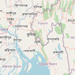
Map view of Rajbari National Park

Use this park location map to pinpoint Rajbari National Park in India, understand its exact geographic position, and read its mapped placement within the surrounding landscape more clearly.

Pigeon | © OpenStreetMap contributors

Location context for Rajbari National Park

Tripura
Park atlas

Browse the regional spread of national parks and protected areas adjacent to Rajbari National Park.

Parks Near Rajbari National Park: Discover Other Protected Areas in Northeastern India

After exploring Rajbari National Park, continue your journey by browsing other national parks and protected areas found in its surrounding northeastern India region. This allows for direct geographic comparison of conservation landscapes, mapping the distribution of tropical forests and wildlife habitats across the wider regional context.
Protected areaTripura
About 26 km away#1 closest

North

Rudrasagar Lake: Protected Wetland and Monsoonal Sedimentation Basin in Tripura

Geography, hydrology, and cultural heritage of a Ramsar-listed site

Rudrasagar Lake is a key freshwater wetland situated in northeastern India, defined by its role as a natural sediment trap and wintering ground for threatened waterfowl species. Learn about the lake's monsoonal water fluctuations, the soft sedimentary terrain of its catchment, and the inclusion of the historic Neermahal palace within this protected basin.

Area
5.3 km²
Scope
Terrestrial
Water
Water-dominated
National parkTripura
About 44 km away#2 closest

North

Clouded Leopard National Park: National Park Protected Area in Tripura's Forested Landscape

Mapped primate habitat and regional geography in Northeast India.

Clouded Leopard National Park serves as a critical protected area within Tripura, India, focusing on the conservation of its forest ecosystems and primate populations, including the Phayre's langur. As part of the larger Sepahijala Wildlife Sanctuary, its mapped boundaries contribute to the regional protected landscape. This national park offers valuable insight into the natural terrain and biodiversity specific to Northeast India, providing a unique geographic focus for atlas exploration.

Area
5.08 km²
Established
2007
IUCN
II
Climate
Tropical
National parkChittagong District
About 75 km away#3 closest

South

Baroiyadhala National Park: A Vital Wildlife Corridor and Protected Forest Landscape in Bangladesh

Discover its terrain, mapped boundaries, and regional significance.

Baroiyadhala National Park, situated in Bangladesh's Chittagong District, stands as a critical national park dedicated to preserving forest ecosystems and functioning as an essential wildlife corridor. The park's undulating terrain and dense vegetation are vital for supporting threatened species and maintaining habitat connectivity. This page offers an atlas-style exploration of Baroiyadhala National Park, detailing its protected area status, geographic context within the Chittagong region, and its significance for conservation in South Asia, providing a rich understanding of its natural landscape.

Area
29.34 km²
Established
2010
IUCN
II
Climate
Tropical
National parkHabiganj District
About 93 km away#4 closest

North

Satchari National Park: Mapped Protected Landscape in Habiganj District

Discover regional geography and park boundaries.

Satchari National Park represents a significant protected area within Bangladesh, situated in Habiganj District. This entry focuses on its identity as a national park, detailing its geographic footprint and landscape context. Explore the mapped dimensions of this protected land to better understand its role in the regional atlas and its specific natural terrain.

Area
2.43 km²
Established
2005
IUCN
II
Relief
Highland
National parkRangamati District
About 119 km away#5 closest

Southeast

Kaptai National Park: Protected Landscape and Geographic Context in Rangamati District

Explore its mixed evergreen forest and lakeside terrain.

Kaptai National Park is a crucial protected area located in Bangladesh's Rangamati District, renowned for its mixed evergreen forests and unique position adjacent to Kaptai Lake. This detail page provides an atlas-oriented perspective on the park's geographic identity, mapped boundaries, and its role within the diverse Chittagong Hill Tracts region. Understand the terrain, from rolling hills to lakeside environments, and appreciate its conservation significance as a national park.

Area
54.64 km²
Established
1999
IUCN
II
Climate
Subtropical
National parkMoulvibazar District
About 122 km away#6 closest

North

Lawachara National Park: Protected National Park Landscape in Moulvibazar District

Mapped Terrain and Endangered Primate Habitat Exploration

Delve into the protected landscape of Lawachara National Park, a key national park located in the distinct undulating terrain of Moulvibazar District, Bangladesh. This area is recognized for its ecological significance, particularly as a sanctuary for endangered primates, including the critically important western hoolock gibbon population. Users can explore the park's mapped boundaries, understand its semi-evergreen forest ecosystem, and appreciate its geological features like sandstone hillocks and sandy-bedded streams, making it a valuable point of discovery for regional geography and conservation landscapes.

Area
12.5 km²
Established
1996
IUCN
II
Relief
Upland
National parkBangladesh
About 136 km away#7 closest

Northwest

Bhawal National Park: Mapped Protected Landscape in Bangladesh

Explore its national park designation and regional geography.

Bhawal National Park represents a key protected landscape within Bangladesh. This entry provides detailed information on its identity as a national park, focusing on its mapped geography and protected area significance. Users can explore the park's specific context within the broader South Asian region, understanding its contribution to the nation's conserved natural areas and gaining insight into its landscape character through an atlas-driven perspective.

Area
50.22 km²
Established
1982
IUCN
IV
Relief
Lowland
National parkBangladesh
About 138 km away#8 closest

South

Nijhum Dweep National Park: A Protected Landscape in Bangladesh's Geographic Atlas

Explore the mapped boundaries and regional setting of this national park.

Nijhum Dweep National Park is a key protected area situated within the deltaic geography of Bangladesh. This detailed entry provides insight into its mapped landscape, natural terrain, and its significance as a national park. Understand its geographic context and explore its protected boundaries as part of a broader atlas of natural areas, offering a factual basis for understanding this unique South Asian landscape.

Area
163.52 km²
Established
2001
IUCN
IV
Relief
Lowland

Common questions about visiting, size, designation, and location context for Rajbari National Park

Rajbari National Park FAQs for park facts, access, geography, and protected area context

Find quick answers about Rajbari National Park, including protected-area facts, park geography, trail and visitor context, and how the park fits into its surrounding country and regional landscape.
MoriAtlas Explorer

Continue Your Protected Areas Search Across the Global Atlas

Deepen your exploration by continuing the structured search for national parks and protected areas worldwide. Utilize the comprehensive filtering capabilities to compare different conservation landscapes and refine your understanding of global park geography. Discover more about the distribution and characteristics of protected natural areas.

Global natural geography
