
Mori Atlas logo
Nature reserveReserva Municipal Aquicuana

Tracing the intersection of traditional community heritage and vital Amazonian wilderness boundaries

Reserva Municipal Aquicuana: Mapping Amazonian Forest Landscapes and Protected Biodiversity in Beni Department

Reserva Municipal Aquicuana stands as a critical nature reserve within the Beni Department, protecting over 20,000 hectares of diverse Amazonian terrain. The landscape features the central Lago San José, surrounded by dense broadleaf forest, seasonal wetlands, and riparian corridors that host hundreds of bird species. This protected area uniquely integrates traditional Tacana community life with conservation goals, serving as a sanctuary for both endemic wildlife and ancestral medicinal plant traditions.

Amazon rainforestmunicipal reservefreshwater lakeindigenous heritageTacana culturecommunity forest landscape
Stylized digital illustration showing a view through tropical foliage toward a calm river or lake, surrounded by dense forest and pinkish rocky cliffs under a soft-toned sky.

Reserva Municipal Aquicuana

Nature reserve

Park overview

Structured park overview, official facts, and landscape profile for Reserva Municipal Aquicuana

Reserva Municipal Aquicuana park facts, protected area profile, and essential visitor context

Review the core facts for Reserva Municipal Aquicuana, including designation, size, terrain, visitor scale, habitats, and operating context in one park-focused overview.

About Reserva Municipal Aquicuana

Reserva Municipal Aquicuana sits within the heart of the Bolivian Amazon, in the northern lowlands where the departments of Beni and Pando meet near the Brazilian border. Administratively, the reserve belongs to the municipality of Riberalta in the province of Vaca Díez, and its geographic center lies on the shores of Lago San José. The lake gives the reserve its defining landscape character: a quiet body of water fringed by rainforest, where caimans, anhingas, and neotropical cormorans are commonly observed.

The reserve is significant ecologically because it conserves a large block of intact Amazonian forest that would otherwise be vulnerable to agricultural expansion, cattle ranching, deforestation, and extractive pressures. The 2016 expansion, which enlarged Aquicuana to more than 20,000 hectares, was explicitly designed to create a buffer against these threats while preserving the territories and livelihoods of the communities already living within the area. Forests of large emergent trees, strangler figs, and a rich understory of palms and lianas characterize the habitat around the lake and along the streams that feed it.

Aquicuana is notable also for being a reserve with people inside it. The two communities of San José and Warnes are not peripheral to the reserve but live within it, depending directly on the forest, the lake, and the surrounding agricultural land. San José traces its origins to rubber-tapping families in 1975, while Warnes was founded in 1957. Their economies rely on fishing, rice, plantains, cassava, and the harvest of Brazil nuts, with surplus sold in the Riberalta market. This coexistence of biodiversity protection and traditional rural Amazonian life gives Aquicuana a character closer to a community forest landscape than to a strictly exclusionary park.

Within the reserve, the Pisatahua center adds another layer of identity. Pisatahua operates as an integrative retreat focused on medicinal plants and ayahuasca, drawing on Tacana and broader Amazonian plant knowledge. The presence of this center underscores how Aquicuana is understood both as a natural reserve and as a place where cultural, spiritual, and ecological heritage are preserved together, in a manner consistent with long-standing traditions in this part of the Bolivian Amazon.

Quick facts and research context for Reserva Municipal Aquicuana

Reserva Municipal Aquicuana is a municipally managed protected area in the Vaca Díez province of the Beni department in northern Bolivia, within the Amazon basin. It surrounds Lago San José, an ancestral lake whose name comes from the Tacana language and signifies 'place of great trees.' The reserve's modern protected-area history began in 1995 with a municipal protection law for the lake, expanded to roughly 1,600 hectares by 2004, and later grew to more than 20,000 hectares through a 2016 expansion involving Sustainable Bolivia and Fundación Amazonía.

The reserve contains more than 330 recorded bird species, an estimated forty frog species, and characteristic Amazonian mammals such as jaguars, armadillos, and several monkey species. Two communities, San José and Warnes, live within the reserve and depend on the forest for their livelihoods, an unusual feature that gives Aquicuana both ecological and cultural significance. Pisatahua, a medicinal plant and ayahuasca retreat center, operates within the reserve as additional expression of its human-environmental identity.

Protection and recognition

Examine the official protection scope and documented conservation status for this terrestrial reserve.

Reserva Municipal Aquicuana Protection Status and Terrestrial Designation

Reserva Municipal Aquicuana maintains a documented terrestrial protection scope within its regional conservation framework. Official records outline the established designation details and management context for reliable geographical analysis.

Protection details

Protection scope
Terrestrial
Transboundary protection
No
Park context

Deeper park guide and search-rich context for Reserva Municipal Aquicuana

Reserva Municipal Aquicuana history, landscape, wildlife, and travel context

Explore Reserva Municipal Aquicuana through its history, landscape character, ecosystems, wildlife, conservation priorities, cultural context, and seasonal travel timing in a structured park guide built for atlas discovery and search intent.

Why Reserva Municipal Aquicuana stands out

Aquicuana is best known for protecting Lago San José and its surrounding Amazonian rainforest within a municipal reserve framework that also sustains indigenous and traditional communities. Its bird diversity is among its most distinctive features, with more than 330 recorded species, including the endemic and IUCN-vulnerable Tororoí Riberalteño, which exists only in the Riberalta area. The reserve is also recognized as a place where Tacana cultural heritage, traditional plant medicine, and Amazonian community life are intertwined with conservation practice.
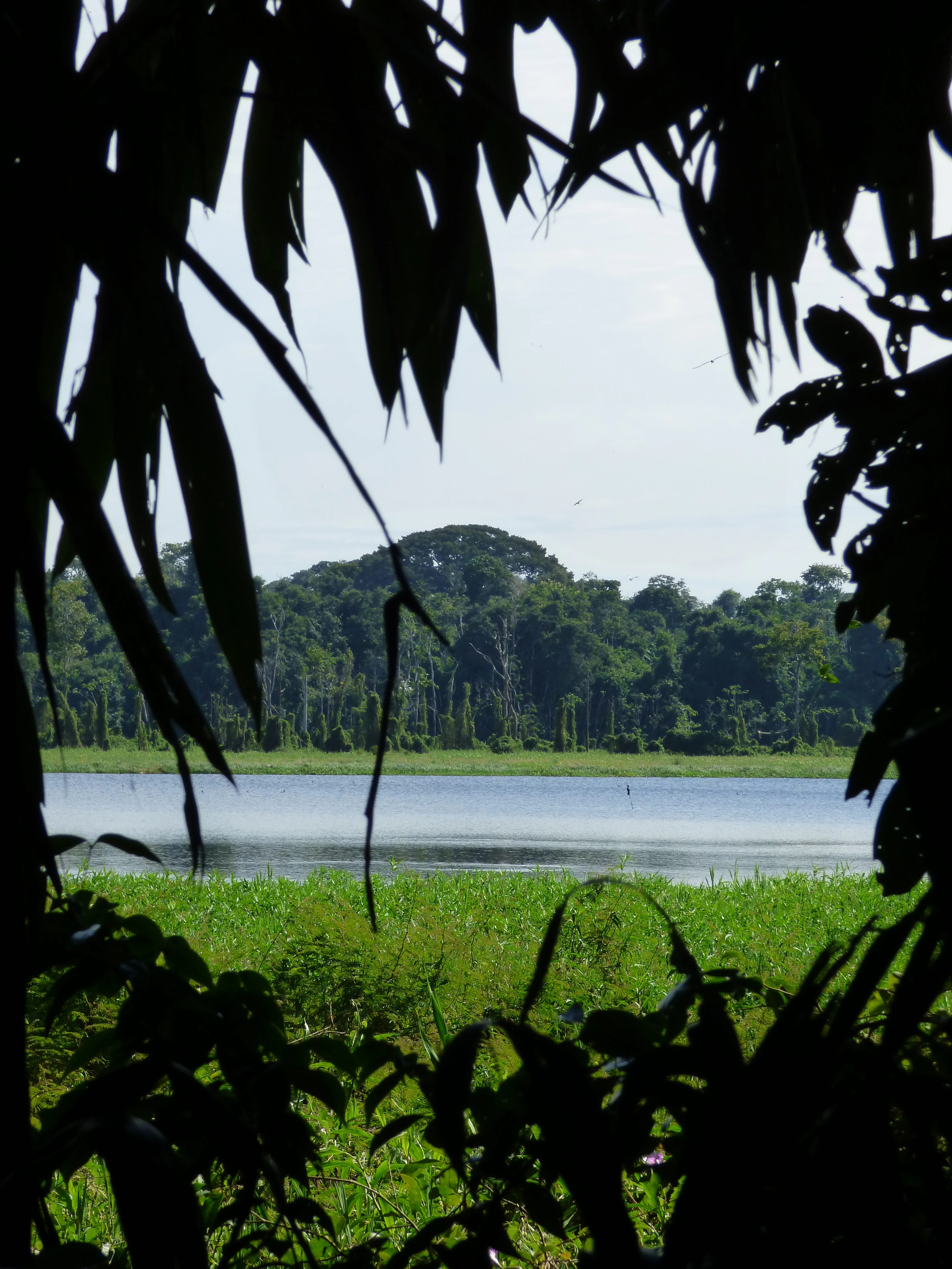
A tranquil lake framed by the dark, silhouetted leaves and branches of jungle trees in the foreground, with a lush green shoreline and dense forest in the background.
A view of Lago San Jose framed by jungle foliage within the Reserva Municipal Aquicuana.

Reserva Municipal Aquicuana history and protected-area timeline

The formal history of the reserve begins in 1995, when the municipality of Riberalta passed its first protection law for Lago San José, recognizing the ecological and cultural importance of the lake and its surrounding forest. In 2004, the municipal government extended the boundaries, creating a protected block of about 1,600 hectares around the lake.

A more transformative moment came in 2016, when the reserve was expanded to more than 20,000 hectares. This expansion was carried out through collaboration among the municipal government of Riberalta, the resident communities of San José and Warnes, and partner organizations including Sustainable Bolivia and Fundación Amazonía. The stated purpose of both the original protection and the later expansion was to defend the territory against the expansion of industrial-scale agriculture and cattle ranching, deforestation, mining, and broader natural resource extraction, while also ensuring dignified living conditions for the communities that have historically inhabited the area.

Human presence in the area considerably predates the reserve itself. The community of Warnes was established on 16 June 1957 by livestock farmers attracted by the forested setting and the access to water and education, while San José was founded in 1975 by approximately fifteen families who settled near the river during the era of the rubber company Casa Suárez. Although the rubber enterprise collapsed almost immediately, the families remained, and San José still comprises roughly twenty-seven families, around two hundred people, who maintain a community governance structure with a president elected every two years by heads of household.

Reserva Municipal Aquicuana landscape and geographic character

The landscape of Reserva Municipal Aquicuana is classic lowland Amazonian rainforest, with an integrated network of lakes, streams, flooded forest, and terra firme forest. Lago San José is the reserve's central landform, a calm forested lake surrounded by dense vegetation that filters views across the water into layered jungle. The lake is the primary focal point both for wildlife observation and for the reserve's cultural sites.

Beyond the lake, the terrain continues as relatively flat Amazonian plain, dominated by tall broadleaf forest, emergent trees, strangler figs, palm stands, and the dense understory characteristic of the Beni lowlands. The reserve lies close to the departmental border with Pando and the international frontier with Brazil, placing it in a transitional zone of southwestern Amazonia. Riparian corridors and seasonal flooding shape parts of the forest, while the higher ground around the lake supports the large canopy trees that gave the place its ancestral Tacana name, Aquicuana, meaning 'place of great trees.'

The reserve lies about 20 kilometers from Riberalta, making it physically accessible while still retaining a wilderness character. Trails for hiking and wildlife observation thread through the forest, and the lake's edges and inlets provide open vantage points where visitors can observe wildlife in a setting that combines wetland, forest, and human settlement in close proximity.
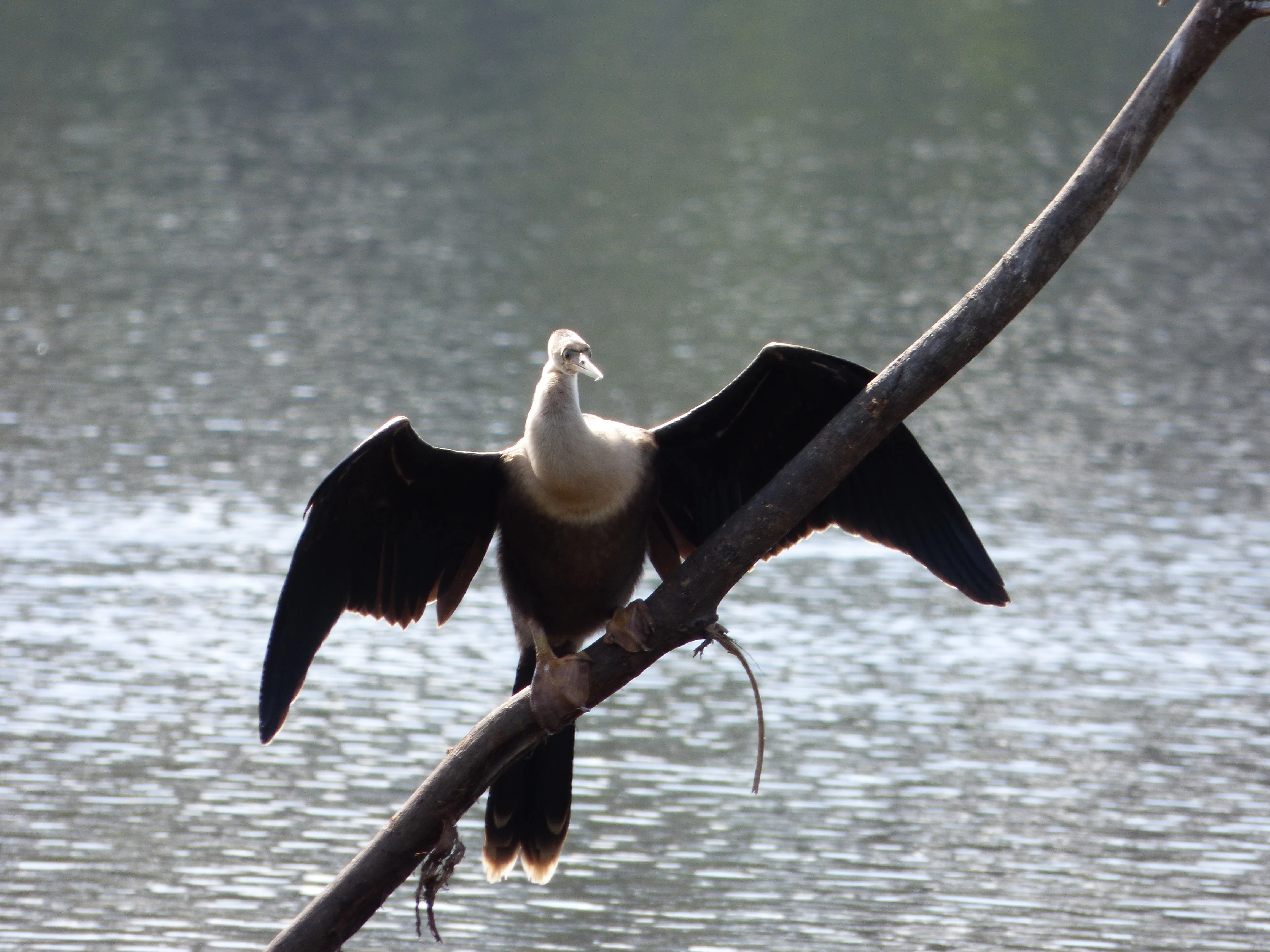
A bird with dark, outspread wings and a light-colored neck and head perches on a diagonal branch over shimmering water.
An anhinga drying its wings while perched on a branch above the waters of Lago San Jose within the Aquicuana reserve.

Reserva Municipal Aquicuana ecosystems, habitats, and plant life

The ecosystems of Aquicuana mirror the broader Amazonian environment of northern Beni, with terra firme rainforest as the dominant habitat, complemented by riparian forest along streams and wetland margins around Lago San José. The forest structure includes tall canopy trees, strangler figs, palms, lianas, and a rich understory, creating layered habitat that supports high faunal and floral diversity. Although no exhaustive biological inventory of the reserve has yet been completed, partial studies have documented substantial biodiversity across mammals, amphibians, birds, and insects.

The lake and its wetland fringe function as a particularly important habitat patch within the broader forest matrix. Aquatic and semi-aquatic habitats around Lago San José concentrate birdlife, including cormorants, anhingas, and other waterbirds, while caimans occupy the lake itself. The mosaic of flooded and dry forest, combined with the lake, creates the kind of edge-rich habitat structure that is typical of the well-conserved southwestern Amazon.

Aquicuana also holds cultural-ecological value through the presence of Pisatahua, a retreat and research environment focused on medicinal plants and ayahuasca, situated within the Amazonian forest. This integration of traditional plant knowledge with forest conservation gives the reserve an additional layer of ecological and cultural significance, connecting forest biodiversity to long-standing practices of plant use in the Tacana tradition.

A group of six dark-colored cormorants swimming in a single file line across the calm, rippled surface of a lake.
A small group of cormorants swimming across Lago San Jose within the Aquicuana reserve.

Reserva Municipal Aquicuana wildlife and species highlights

Reserva Municipal Aquicuana supports a rich Amazonian fauna across mammals, amphibians, birds, and insects, reflecting the intact quality of its forest and the diversity of habitats around Lago San José. Mammals documented in the reserve include jaguars, armadillos, and several monkey species, which together indicate a functioning predator-prey system and a strong forest mammal community.

The reserve's amphibian fauna is particularly notable for frogs, with approximately forty identified species so far. Among them, the green tree frog Phyllomedusa camba and the Suriname toad, sometimes called Pipa pipa, are among the more recognizable. This amphibian richness is consistent with the humid tropical environment that defines the area.

Aquicuana's birdlife is among its most distinctive features. More than 330 species have been recorded, including the collared aracari, often called Tucanillo locally, the scarlet macaw, and three other Ara species. A particularly important presence is the Riberalta antpitta, Hylopezus auricularis, an endemic species classified as vulnerable by the International Union for Conservation of Nature, found only in the Riberalta area and its surroundings. Neotropical cormorants and anhingas are commonly observed around the lake, sometimes sharing the shoreline with black caimans in dramatic scenes of coexistence.

Among insects, butterflies are a visible and characteristic presence. Species such as Biblis hyperia, the red-banded butterfly of the area, and the blue Morpho deidama are common, illustrating the broader patterns of Amazonian insect diversity that emerge wherever the forest canopy and understory remain well preserved.
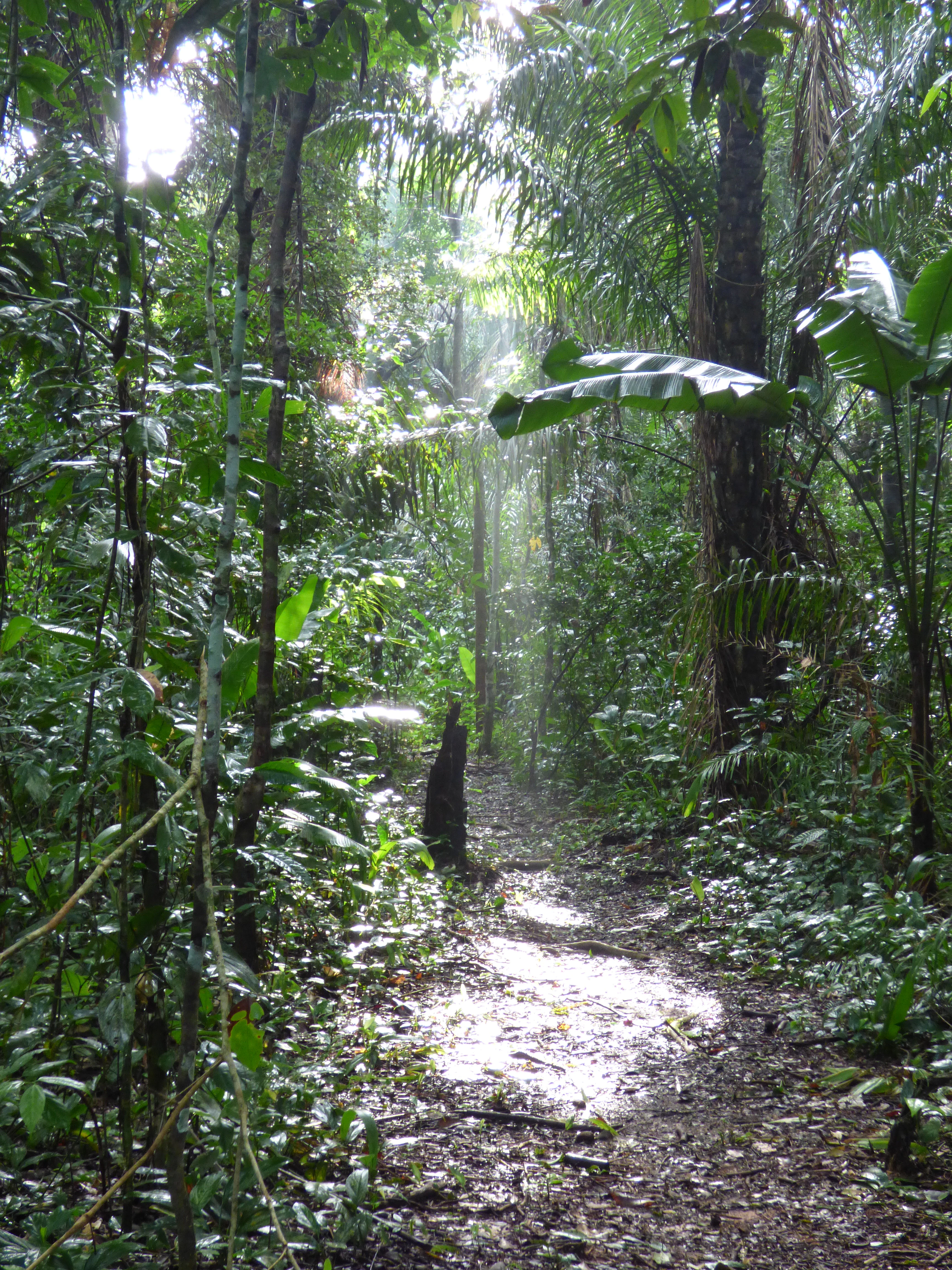
A narrow dirt hiking path leading into a dense, green tropical rainforest, with shafts of sunlight filtering through the canopy onto the forest floor.
A sunlight-dappled hiking trail winding through the dense tropical forest of Reserva Municipal Aquicuana.

Reserva Municipal Aquicuana conservation status and protection priorities

The principal conservation significance of Reserva Municipal Aquicuana lies in the protection of a large block of Amazonian forest and a freshwater lake ecosystem in a region facing strong pressures from agriculture, cattle raising, deforestation, mining, and resource extraction. The reserve was created and later expanded specifically as a buffer against these pressures, with municipal, community, and institutional actors working together to maintain a continuous forested landscape around Lago San José.

The 2016 expansion to more than 20,000 hectares, achieved through a partnership that included the Riberalta municipal government, Sustainable Bolivia, and Fundación Amazonía, is a defining moment in the reserve's conservation history. By encompassing a much larger territory, the reserve gained room for ecological processes to function across a meaningful landscape, including migration routes, seasonal flooding patterns, and the habitat needs of wide-ranging species such as the jaguar.

Aquicuana also helps protect forest-based livelihoods and the integrity of two established communities, San José and Warnes. This model reflects an approach in which biodiversity conservation is not separated from local rural life but supported alongside it, with fishing, Brazil nut harvesting, and small-scale agriculture maintained within the reserve. The reserve's protected status also contributes indirectly to the conservation of species of global concern, including the Riberalta antpitta, whose restricted range makes reserves like Aquicuana essential to its continued survival.

Reserva Municipal Aquicuana cultural meaning and human context

Reserva Municipal Aquicuana carries a strong cultural identity rooted in Tacana language and Amazonian traditional knowledge. The name of the reserve, Aquicuana, comes from the ancestral Tacana name for Lago San José, meaning 'place of great trees,' linking modern conservation to long-standing indigenous place-based knowledge.

The reserve is also shaped by the presence of two resident communities, San José and Warnes. Warnes was founded by cattle-raising families in 1957, while San José was established in 1975 by families who came to the area during the rubber boom associated with the Casa Suárez company. Today these communities maintain traditional livelihoods such as Brazil nut harvesting, fishing, cassava cultivation, rice, and plantains, and they govern themselves through elected communal presidents. Their continued presence within the reserve gives Aquicuana a distinctly human dimension that is uncommon in conventional protected areas.

Within the reserve, Pisatahua operates as a center dedicated to medicinal plants and ayahuasca-based integrative retreats. Drawing on Tacana and broader Amazonian plant traditions, Pisatahua represents the persistence of indigenous and rural healing knowledge within a formally protected landscape, reinforcing the view that Aquicuana is not only an ecological reserve but also a living cultural territory.

Top sights and standout views in Reserva Municipal Aquicuana

The principal highlights of Reserva Municipal Aquicuana are the protected Lago San José and its surrounding Amazonian forest, the presence of more than 330 recorded bird species, and the integration of two long-standing communities within the reserve boundaries. Riberalta antpitta, an endemic vulnerable species, is among the most distinctive conservation values the reserve protects, alongside jaguars and the abundant heron-like wetland birdlife of the lake.

Equally significant is the cultural dimension: the reserve's Tacana name, its resident communities of San José and Warnes, and the Pisatahua medicinal plant center together give Aquicuana a profile in which biodiversity, traditional livelihoods, and indigenous plant knowledge are recognized as parts of a single landscape.

Best time to visit Reserva Municipal Aquicuana

Reserva Municipal Aquicuana has a hot, humid tropical climate year-round, with two broad seasonal moods. From October through April the area is dominated by the wet season, when heavy rains, high humidity, and frequent precipitation shape the landscape, with annual rainfall that can reach up to around 4,000 millimeters. From May through September the climate shifts to a drier pattern, though it remains warm overall, with temperatures that usually do not exceed about 35 degrees Celsius and can drop below 20 degrees when cool southern winds arrive.

For visitors, the drier period between May and September generally offers more comfortable conditions for hiking, wildlife observation, and travel along forest trails, while the wetter months deliver the richest display of forest vitality, with rising water levels, lush vegetation, and intense frog and insect activity around the lake. Either season can be rewarding, and the choice depends more on whether the visitor prioritizes comfortable walking conditions or the full spectacle of Amazonian wet-season life.
Monthly climate preview

Long-term temperature ranges and monthly precipitation cycles across the representative coordinate

Reserva Municipal Aquicuana Climate Normals and Annual Weather Patterns

Representative coordinate records show that Reserva Municipal Aquicuana experiences distinct shifts in monthly temperature and precipitation throughout the historical observation period. Reviewing the complete twelve-month meteorological profile provides deeper analytical context for long-term regional climate conditions.
Annual mean26 °C
24 °C29 °C
Jan26°
Feb25°
Mar25°
Apr25°
May25°
Jun24°
Jul26°
Aug28°
Sep29°
Oct29°
Nov27°
Dec26°
Warmest month
September

29.3 °C

Coolest month
June

24.5 °C

Wettest month
February

9.5 mm/day

Driest month
July

0.5 mm/day

Park location guide

Geography guide, regional context, and park location map for Reserva Municipal Aquicuana

Reserva Municipal Aquicuana park geography, regions, and map view in Bolivia

Understand where Reserva Municipal Aquicuana sits in Bolivia through a broader geographic reading of the surrounding landscape, nearby location context, and its mapped position within the national park landscape.

How Reserva Municipal Aquicuana fits into Bolivia

Bolivia, officially the Plurinational State of Bolivia, is a landlocked country in central South America. It features diverse geography including the Andean mountain range, Amazonian plains, Gran Chaco, and the Pantanal wetland. The country has a population of approximately 11.4 million and is administratively divided into nine departments, with La Paz as the seat of government and Sucre as the constitutional capital.

Wider geography shaping Reserva Municipal Aquicuana in Bolivia

Bolivia is located in central South America, bordered by Brazil to the north and east, Paraguay to the southeast, Argentina to the south, Chile to the southwest, and Peru to the west. The country is divided between a western Andean region and tropical lowlands to the east and north. It includes the Amazonian plain, Gran Chaco, temperate valleys, the high-altitude Altiplano plateau, and part of the Pantanal wetland along its eastern border.

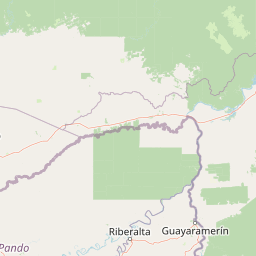
Map view of Reserva Municipal Aquicuana

Use this park location map to pinpoint Reserva Municipal Aquicuana in Bolivia, understand its exact geographic position, and read its mapped placement within the surrounding landscape more clearly.

Pigeon | © OpenStreetMap contributors

Location context for Reserva Municipal Aquicuana

Beni Department

Visual reference collection showcasing Lago San José, floodplain forest habitats, and local conservation terrain

Reserva Municipal Aquicuana Photos: Amazon Rainforest Scenery and Protected Area Landscapes

Photographic documentation reveals the lowland Amazonian rainforest, dense broadleaf canopy, and freshwater lake habitats preserved within Reserva Municipal Aquicuana. Visual records provide clear insight into the protected landscape, riparian terrain, and ecological character of this Beni basin reserve.

A tranquil lake framed by the dark, silhouetted leaves and branches of jungle trees in the foreground, with a lush green shoreline and dense forest in the background.

A small boat with two people fishing on a calm lake, silhouetted against a backdrop of dense forest and a light, misty sky at sunrise.

A bird with dark, outspread wings and a light-colored neck and head perches on a diagonal branch over shimmering water.

A group of six dark-colored cormorants swimming in a single file line across the calm, rippled surface of a lake.

A narrow dirt hiking path leading into a dense, green tropical rainforest, with shafts of sunlight filtering through the canopy onto the forest floor.

A strangler fig tree in a lush forest with roots wrapping around a host tree trunk.

Park atlas

Compare adjacent lowland rainforest ecosystems and regional conservation lands.

Parks Near Reserva Municipal Aquicuana and Surrounding Amazon Protected Areas

Browsing parks near Reserva Municipal Aquicuana reveals broader ecological patterns across the northern Beni lowlands and adjacent Amazonian river basins. Comparing these protected landscapes helps trace regional biodiversity corridors and connected tropical forest habitats.
A minimalist watercolor painting depicting a soft green landscape with rolling hills in the background and a flat, grassy foreground.
Wildlife reservePando Department
About 141 km away#1 closest

Southwest

Reserva nacional de vida silvestre amazónica Manuripi: Protected Amazonian Wilderness

Map and geographic context of Pando Department wildlife reserves

Spanning over 700,000 hectares, this wildlife reserve safeguards representative Amazonian ecosystems. Explore the hydrological network of the Madre de Dios and Manuripi river basins, ancient Brazil nut stands, and diverse wetland formations that define this significant regional protected area.

Area
7,470 km²
Established
1973
Relief
Lowland
Climate
Tropical
Nature reserveBeni Department
About 316 km away#2 closest

South

Reserva natural Barba Azul: A Protected Savanna Sanctuary in the Beni Department

Mapping flooded grasslands and gallery forest ecosystems

Reserva natural Barba Azul stands as a key protected area within the Bolivian Amazon lowlands. This nature reserve, centered in the Beni Department, preserves a rare mosaic of motacú palm forests and seasonal wetlands that serve as a critical stronghold for endangered parrots and migratory shorebirds within the larger Llanos de Moxos region.

Area
110 km²
Established
2008
Relief
Lowland
Climate
Tropical
A horizontal watercolor painting of a river landscape with lush green vegetation in the foreground and soft, hazy hills in the background.
Protected areaBeni
About 346 km away#3 closest

South

Área protegida municipal Pampas del río Yacuma: Protected Area and Wetland Geography

A large-scale municipal sanctuary in the Bolivian Amazon

This significant protected area encompasses the expansive floodable savannas of the Llanos de Moxos. Its mosaic of forest islands and riverine wetlands provides a critical refuge for endemic species and iconic Amazonian wildlife. The geography is shaped by the Yacuma River, creating a seasonal environment that bridges indigenous heritage with modern conservation land management.

Area
6,164.53 km²
Established
2007
Visitors
16K annual
Relief
Lowland
National parkPeru
About 356 km away#4 closest

Southwest

Bahuaja-Sonene National Park: A Major Amazon Frontier National Park in Peru's Geography

Explore its mapped protected landscape and diverse terrain.

Bahuaja-Sonene National Park is an extensive national park situated on the Amazon frontier in southern Peru, encompassing a crucial transition zone between lowland rainforest and higher-elevation forest ecosystems. Its diverse topography, from river valleys to mountainous slopes, creates varied natural landscapes. The park's protected boundaries are integral to the regional conservation strategy, offering a unique lens through which to study the mapped geography and ecological significance of this vast Amazonian protected area.

Area
10,914.2 km²
Established
1996
IUCN
II
Relief
Mixed relief
National parkLa Paz Department
About 357 km away#5 closest

Southwest

Madidi National Park: National Park Protected Landscape and Geographic Atlas Entry

Explore mapped boundaries and regional context in La Paz Department.

Madidi National Park is a designated national park situated in Bolivia's La Paz Department. This detail entry offers a focused perspective on its protected landscape, its specific geographic setting, and its role within the larger atlas of natural areas. Understand the park's mapped boundaries and its contribution to the regional geography, providing a foundation for structured discovery of Bolivia's protected lands.

Area
18,957.5 km²
Established
1995
IUCN
II
Relief
Mixed relief
A horizontal watercolor painting depicting a soft-focus landscape with green hills, a winding river, and reddish marshy foreground vegetation.
Biosphere reserveBolivia
About 385 km away#6 closest

South

Reserva de Biosfera Estación Biológica del Beni: Protected Landscape and Geographic Atlas

Examining the Amazonian lowland mosaic of northern Bolivia

The Reserva de Biosfera Estación Biológica del Beni sits within the wide alluvial plains of the Llanos de Moxos. This protected area features a unique, flat terrain where tropical forest fragments persist as islands amidst seasonally flooded palm savannas, cyperaceous marshes, and shallow lagoons, providing a critical study area for Amazonian biodiversity.

Area
1,350 km²
Established
1982
Relief
Lowland
Climate
Tropical
Protected areaBeni Department
About 390 km away#7 closest

South

Área Protegida Municipal Rhukanrhuka: Mapping Amazonian Biodiversity and Riverine Terrain

A transitional protected landscape in the Beni Department of Bolivia

Spanning a vast transition from Andean slopes to the Llanos de Moxos floodplain, Área Protegida Municipal Rhukanrhuka protects a dynamic mosaic of white-water rivers, gallery forests, and tectonic lakes. This significant municipal reserve serves as a refuge for threatened species and sustains indigenous Maropa communities within its borders, anchoring an essential conservation corridor in the northern Amazon.

Area
8,594.51 km²
Established
2019
Relief
Lowland
Climate
Tropical
Regional parkBeni
About 425 km away#8 closest

South

Parque regional Yacuma: Geographic Overview and Protected Landscape Mapping

Riparian ecosystems and flooded savanna terrain in Beni, Bolivia

Explore the expansive floodplain mosaic of Parque regional Yacuma, where the Yacuma and Beni river systems create a vital refuge for lowland wildlife. The park offers an essential view into the seasonal transitions of northern Bolivia, bridging pre-Andean forests and inundated savanna plains that define this significant regional conservation corridor.

Area
1,200 km²
Established
1990
Water
Major water bodies

Common questions about visiting, size, designation, and location context for Reserva Municipal Aquicuana

Reserva Municipal Aquicuana FAQs for park facts, access, geography, and protected area context

Find quick answers about Reserva Municipal Aquicuana, including protected-area facts, park geography, trail and visitor context, and how the park fits into its surrounding country and regional landscape.
MoriAtlas Explorer

Continue Your Protected Areas Search Across the Global Atlas

Deepen your exploration by continuing the structured search for national parks and protected areas worldwide. Utilize the comprehensive filtering capabilities to compare different conservation landscapes and refine your understanding of global park geography. Discover more about the distribution and characteristics of protected natural areas.

Global natural geography