
Mori Atlas logo
Biosphere reserveReserva de la biosfera de las Tierras del Miño

Tracing the riverine landscapes and riparian forests across the upper basin of the Miño river.

Reserva de la biosfera de las Tierras del Miño: A Comprehensive Geographic and Protected Area Map

(Reserva de la Biosfera de las Tierras del Miño)

Discover the complex geography of Reserva de la biosfera de las Tierras del Miño, an expansive protected landscape within Galicia, Spain. This territory centers on the upper basin of the Miño river, showcasing high-quality fluvial ecosystems, transitional wetlands, and diverse forested terrain. The mapped boundaries reveal a unique integration of riparian habitats and traditional rural settlements that characterize this protected region.

biosphere reserveriparian forestriver ecosystemwetlandslagoonsgalicia
A digital illustration of a lush river valley with green trees, yellow flowers in the foreground, and distant mountains under a soft sunlit sky.

Reserva de la biosfera de las Tierras del Miño

Biosphere reserve

Park overview

Structured park overview, official facts, and landscape profile for Reserva de la biosfera de las Tierras del Miño

Reserva de la biosfera de las Tierras del Miño park facts, protected area profile, and essential visitor context

Review the core facts for Reserva de la biosfera de las Tierras del Miño, including designation, size, terrain, visitor scale, habitats, and operating context in one park-focused overview.

About Reserva de la biosfera de las Tierras del Miño

The Reserva de la biosfera de las Tierras del Miño is one of the most extensive biosphere reserves in Spain, occupying a large portion of the province of Lugo in Galicia. Its setting centers on the upper Miño basin, a region shaped by a dense network of rivers, streams, lagoons, and associated wetlands that flow northward toward the Cantabrian coast. Within this landscape, riparian forests along the Miño and its tributaries stand out as one of the most outstanding riverine ecosystems of the Iberian Peninsula, hosting ancient trees and ecologically valuable aquatic vegetation.

The biosphere extends across 26 municipalities organized in seven comarcas that include coastal-influential areas of the Mariña region (Occidental and Central), the extensive Tierra Chá plains, the comarcas of Meira, Sarria, Los Ancares, and the central area around Lugo itself. This breadth links the inner Galician countryside with closer proximity to the northern coast, producing a varied territory that combines interior river valleys, open agricultural plains, forested ridges, and traditional rural settlements.

A defining trait of the Tierras del Miño reserve is that it is not a strictly protected core: it is a working landscape where biodiversity conservation, cultural heritage, and economic activity are intended to coexist. Rural communities, agricultural traditions, and historical settlement patterns form part of the value of the reserve alongside its natural assets. This balance is reflected in the UNESCO designation, which recognizes the area as an ecologically representative territory where the relationship between people and nature is central to conservation outcomes.

Quick facts and research context for Reserva de la biosfera de las Tierras del Miño

The Reserva de la biosfera de las Tierras del Miño is a UNESCO Biosphere Reserve located in the interior of the province of Lugo, Galicia, in northwestern Spain. Declared by UNESCO on 8 November 2002, it is the largest biosphere reserve in Galicia and the second largest on peninsular Spain, covering roughly 363,668.9 hectares across 26 municipalities organized into seven comarcas of the upper Miño river basin. A large share of its territory falls within the Natura 2000 network, including the Sites of Community Importance (LICs) known as 'Parga-Ladra-Támoga' and 'O Xistral'.

Protection and recognition

Explore documented terrestrial protection scope, designation year, and official recognition records

Reserva de la biosfera de las Tierras del Miño Protection Status and Designation History

Reserva de la biosfera de las Tierras del Miño features documented terrestrial protection status established in 2002 across its managed landscape. Official designation records outline the historical framework of the protected area without unverified international recognition claims.

Protection details

Protection scope
Terrestrial
Designated year
2002
Transboundary protection
No
Park context

Deeper park guide and search-rich context for Reserva de la biosfera de las Tierras del Miño

Reserva de la biosfera de las Tierras del Miño history, landscape, wildlife, and travel context

Explore Reserva de la biosfera de las Tierras del Miño through its history, landscape character, ecosystems, wildlife, conservation priorities, cultural context, and seasonal travel timing in a structured park guide built for atlas discovery and search intent.

Why Reserva de la biosfera de las Tierras del Miño stands out

The reserve is best known for the riparian forests and fluvial ecosystems of the Miño river and its tributaries, which are considered among the finest riverine landscapes of mainland Spain. The territory combines these water-rich habitats with surrounding rural landscapes, sustaining centuries-old trees, aquatic plants, protected species, and a continuity between natural and human-modified environments that defines its biosphere identity.
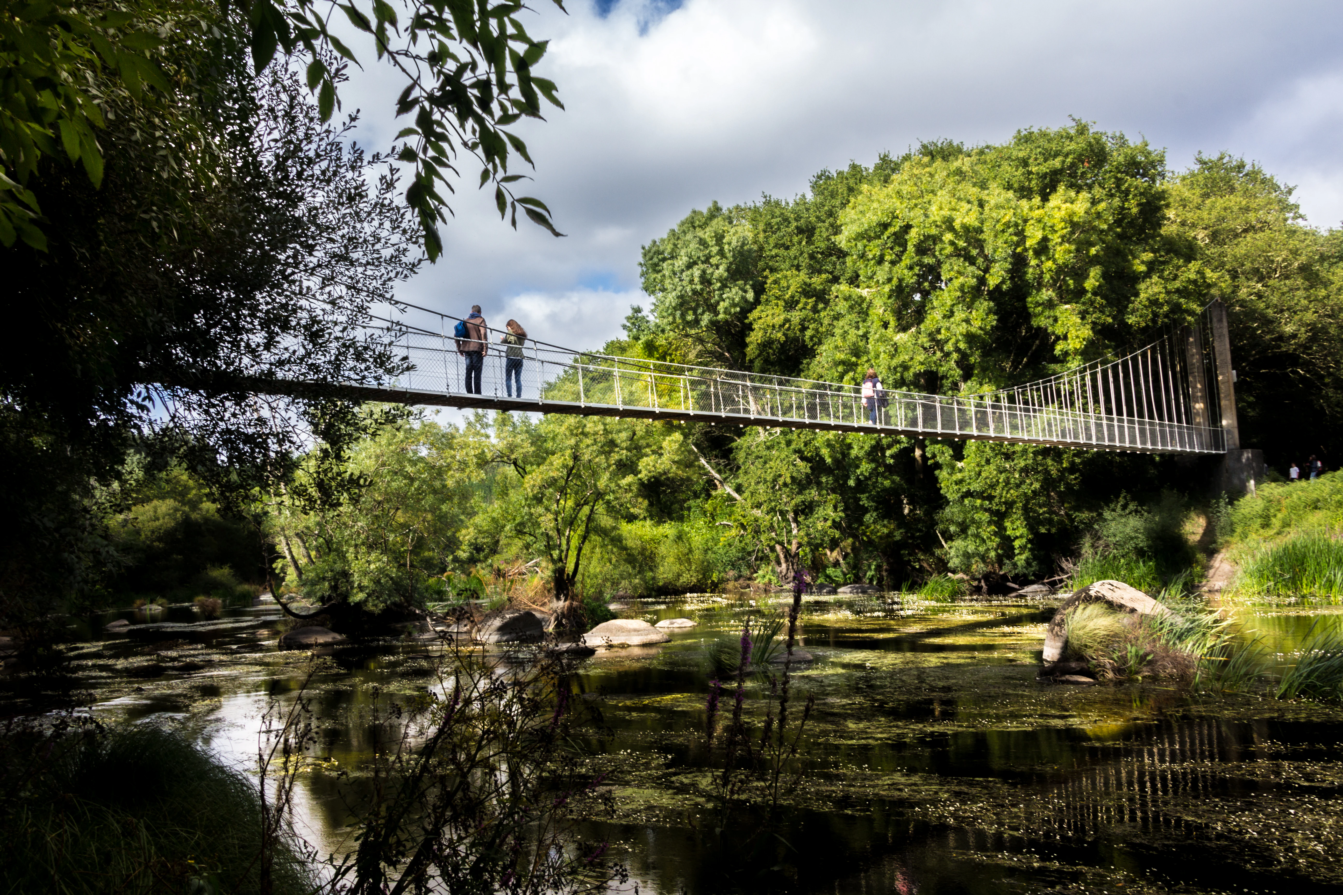
A metal suspension bridge crosses a slow-moving river surrounded by dense green trees and vegetation.
A suspension bridge spanning the Miño River at Insua de Seivane.

Reserva de la biosfera de las Tierras del Miño history and protected-area timeline

The Reserva de la biosfera de las Tierras del Miño was designated a UNESCO Biosphere Reserve on 8 November 2002, formalizing international recognition of the ecological and cultural value of the upper Miño basin in Galicia. The designation brought together 26 municipalities under a single coordinated framework of conservation and sustainable development.

Since its declaration, the area has been increasingly integrated into European conservation networks. A significant portion of the reserve falls within the Natura 2000 framework, including the Lugar de Importancia Comunitaria (LIC, Site of Community Importance) named 'Parga-Ladra-Támoga', also referred to as the 'paisajes del agua' (water landscapes), and the LIC known as 'O Xistral'. This integration reflects the growing importance of the territory's riverine and wetland systems within broader European biodiversity policy.

Reserva de la biosfera de las Tierras del Miño landscape and geographic character

The landscape of the Tierras del Miño reserve is defined by the upper basin of the Miño river, with an intricate system of rivers, streams, lagoons, transitional wetlands, and riparian corridors shaping much of the territory. These water features carve through both open plains and forested valleys, creating the characteristic mosaic that frames the reserve's identity.

Major landscape contrasts within the reserve include the wet plains and wetlands of Tierra Chá, including the well-known Lagoa de Cospeito, as well as the elevated, forested terrain of areas like O Xistral and the foothills of the Cantabrian Mountains along the eastern margins near Los Ancares. Smaller villages and traditional rural settlements, such as the hamlet of Seivane, sit within this landscape and illustrate the long coexistence between human communities and the river systems.

Reserva de la biosfera de las Tierras del Miño ecosystems, habitats, and plant life

The reserve's natural value rests substantially on its water-related ecosystems. The riparian forests along the Miño and its tributaries are highlighted as among the best riverine ecosystems in Spain, supporting centuries-old trees together with a distinctive community of aquatic plants. These forests function as biological corridors and as critical habitat for diverse species that depend on stable, structured river environments.

Beyond the river corridors, the reserve includes zones such as Parga-Ladra-Támoga, known for its 'water landscapes', and O Xistral, a forested upland area recognized for its ecological value within the Natura 2000 network. Together, these habitats provide a continuum from river valleys and lowland wetlands to higher, more forested terrain, contributing to the high floristic and ecological diversity recorded in the reserve.

Reserva de la biosfera de las Tierras del Miño conservation status and protection priorities

The Tierras del Miño reserve's conservation significance lies in the protection of one of the most ecologically valuable riverine systems of mainland Spain, centered on the upper Miño basin. By combining the UNESCO Biosphere Reserve framework with European Natura 2000 designations, the territory benefits from multiple layers of recognition focused on its aquatic and riparian ecosystems.

Two Sites of Community Importance, Parga-Ladra-Támoga ('paisajes del agua') and O Xistral, anchor much of the European-level conservation effort in the reserve, highlighting both its water-rich habitats and its forested upland areas. The biosphere model allows conservation objectives to be pursued alongside the continuation of agricultural, forestry, and rural community activities that have historically shaped the region.

Reserva de la biosfera de las Tierras del Miño cultural meaning and human context

The reserve encompasses long-established rural communities and historical settlement patterns that are integral to its identity as a biosphere. Small villages, traditional hamlets like Seivane, and the broader mosaic of agricultural land use across the comarcas reflect a continuous relationship between the local population and the riverine and rural landscape of the upper Miño basin. This integration of culture, traditional livelihoods, and natural heritage is part of the basis for the UNESCO recognition of the territory.

Top sights and standout views in Reserva de la biosfera de las Tierras del Miño

Among the standout features of the reserve are its riparian forests along the Miño and its tributaries, recognized as among the finest riverine ecosystems of mainland Spain, and its extensive network of wetlands and water-rich landscapes represented by the Parga-Ladra-Támoga area. The forested upland area of O Xistral adds a different ecological dimension within the reserve, while the Lagoa de Cospeito and traditional rural villages illustrate the landscape's blend of natural and cultural elements.

Best time to visit Reserva de la biosfera de las Tierras del Miño

The temperate, wet climate of Galicia shapes the reserve's character throughout the year. Periods of milder weather and longer daylight tend to be favorable for experiencing the riparian forests, lagoons, and rural villages at their most accessible, while wetter seasons emphasize the prominence of water in the landscape that gives the reserve its name. Visitors interested in observing the riverine and wetland ecosystems will find the upper Miño basin's character consistently expressed across the year, with seasonal variation affecting water levels, vegetation, and rural activity.
Monthly climate preview

Long term representative point measurements detailing monthly precipitation and thermal variation

Reserva de la biosfera de las Tierras del Miño Climate Normals and Annual Temperature Rhythm

Representative coordinate records show measured shifts in average monthly temperature and daily precipitation across the terrain of Reserva de la biosfera de las Tierras del Miño. Examining the complete twelve month climatology profile provides deeper insight into long term environmental patterns.
Annual mean12 °C
6 °C20 °C
Jan
Feb
Mar
Apr10°
May13°
Jun17°
Jul20°
Aug20°
Sep17°
Oct13°
Nov
Dec
Warmest month
August

19.8 °C

Coolest month
January

5.8 °C

Wettest month
November

4.2 mm/day

Driest month
July

0.9 mm/day

Park location guide

Geography guide, regional context, and park location map for Reserva de la biosfera de las Tierras del Miño

Reserva de la biosfera de las Tierras del Miño park geography, regions, and map view in Spain

Understand where Reserva de la biosfera de las Tierras del Miño sits in Spain through a broader geographic reading of the surrounding landscape, nearby location context, and its mapped position within the national park landscape.

How Reserva de la biosfera de las Tierras del Miño fits into Spain

Spain, officially the Kingdom of Spain, is a unitary parliamentary constitutional monarchy located in Southern and Western Europe. The country occupies most of the Iberian Peninsula and includes territories in the Mediterranean and Atlantic. With a population of approximately 49.6 million and an area of 506,030 km², Spain is a major European economy and cultural force. Its capital is Madrid, and the country is known for its diverse landscapes ranging from mountainous regions to coastal areas.

Wider geography shaping Reserva de la biosfera de las Tierras del Miño in Spain

Spain occupies the Iberian Peninsula in Southern and Western Europe. Peninsular Spain is bordered to the north by France, Andorra, and the Bay of Biscay; to the east and south by the Mediterranean Sea and Gibraltar; and to the west by Portugal and the Atlantic Ocean. The territory includes the Canary Islands in the Atlantic Ocean, the Balearic Islands in the Mediterranean Sea, and the autonomous cities of Ceuta and Melilla in mainland Africa. Spain features diverse terrain including the Pyrenees in the northeast, the Sierra Nevada in the south, and the Meseta Central plateau.

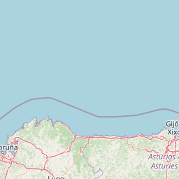
Map view of Reserva de la biosfera de las Tierras del Miño

Use this park location map to pinpoint Reserva de la biosfera de las Tierras del Miño in Spain, understand its exact geographic position, and read its mapped placement within the surrounding landscape more clearly.

Pigeon | © OpenStreetMap contributors

Location context for Reserva de la biosfera de las Tierras del Miño

Galicia
Recorded earthquake history

View Recorded Seismic History for Reserva de la biosfera de las Tierras del Miño

Examine the historical catalogue of seismic activity documented near the Reserva de la biosfera de las Tierras del Miño. This dataset offers clear insight into recorded events around the Miño river basin, curated by MoriAtlas to support geographical discovery and regional landscape research.

Tierras del Miño Earthquake History

Catalogued events

203 events

Strongest magnitude

Magnitude 5.4

Most recent event

Dec 9, 2007

This history includes earthquakes recorded inside the park or within 50 km of its borders

Protected area scenery, riverine habitats, and landscape character in northwestern Spain

Visual Exploration and Photography of Reserva de la biosfera de las Tierras del Miño

Visual records capture the riparian forests, wetland corridors, and riverine ecosystems that define the upper Miño basin. Photographic documentation reveals the terrain, vegetation mosaic, and protected landscape character across the Galician interior.

A metal suspension bridge crosses a slow-moving river surrounded by dense green trees and vegetation.

A wide view over a dense green forest and wetlands under a blue sky with faint wispy clouds, seen from a slightly elevated viewpoint.

Park atlas

Compare regional river basins, wetlands, and nearby protected habitats across Galicia

Parks Near Reserva de la Biosfera de las Tierras del Miño and Surrounding Protected Landscapes

Browsing other protected areas near Reserva de la Biosfera de las Tierras del Miño reveals a broader spectrum of riverine ecosystems and upland terrain throughout the surrounding region. Comparing adjacent natural habitats provides essential context for understanding the wider ecological and geographical patterns of northwestern Spain.
A soft, horizontal watercolor painting showing a calm body of water with gentle grassy banks, trees on the left, and distant rolling hills.
Biosphere reserveGalicia
Park boundaries overlap#1 closest

West

Reserva de la biosfera de las Mariñas Coruñesas y Tierras del Mandeo: Regional Geography and Maps

A diverse protected area across Galicia, Spain

This biosphere reserve serves as a vital ecological refuge along the Cantabrian-Atlantic coast. The protected area features a unique mosaic of marine and terrestrial habitats, ranging from rocky coastal cliffs and sandy estuaries to dense Atlantic forest fragments and the mountainous interior of the Sierra de la Cova da Serpe.

Area
1,139.7 km²
Established
2013
Relief
Mixed relief
Climate
Temperate
Watercolor painting of a wide, rolling mountain landscape with green and muted red hills under a soft, light background.
Biosphere reserveLugo
2.1 km away#2 closest

East

Reserva de la Biosfera de Los Ancares Lucenses y Montes de Cervantes, Navia y Becerreá Protected Area Map

Mountainous terrain and river valley geography in Lugo, Spain

This protected area covers the dramatic Sierra de Ancares, featuring steep mountain slopes and deep river valleys that define the geography of Galicia. The reserve spans a significant vertical relief, providing essential habitats for brown bears and capercaillie while preserving traditional rural mountain land use systems and ancient forest ecosystems.

Area
536.64 km²
Established
2006
Relief
Mountain
Climate
Temperate
A soft watercolor painting depicting rolling green hills, distant mountains, a river, and stylized pink trees against a plain background.
Biosphere reserveProvincia de León
25 km away#3 closest

East

Reserva de la biosfera de los Ancares Leoneses: Protected Mountain Terrain and Atlas

Mapping the Sierra de Ancares river valleys in Provincia de León

Examine the geographic layout and protected boundaries of the Reserva de la biosfera de los Ancares Leoneses. This biosphere reserve serves as a critical mountain corridor, featuring complex river basins and diverse forest cover that highlight the region's environmental and cultural history across the Spanish highlands.

Area
567.86 km²
Established
2006
Relief
Mountain
Scope
Terrestrial
A watercolor painting showing a soft-toned landscape with a stone arch bridge spanning a river, framed by trees and gentle hills.
Biosphere reserveGalicia
61 km away#4 closest

South

Área de Allariz Biosphere Reserve: Mapping the Protected Landscapes of Inland Galicia

Exploring the river basins, granitic massifs, and ecological frontiers

The Área de Allariz biosphere reserve serves as a vital transition zone in northwestern Spain, characterized by its flat-floored tectonic basin, the River Limia, and varied highland terrain. This protected area offers an instructive look at the integration of traditional rural land management with large-scale ecological recovery and conservation across its core, buffer, and transition zones.

Area
214.82 km²
Established
2005
Relief
Mixed relief
Scope
Terrestrial
Watercolor illustration of rolling green hills and distant purple mountains under a light sky
National parkGalicia
81 km away#5 closest

Southwest

Atlantic Islands of Galicia National Park: Protected Archipelagos & Galician Coastline Geography

Explore mapped island ecosystems and protected marine areas.

Uncover the protected landscape of the Atlantic Islands of Galicia National Park, Spain's only national park in Pontevedra province. This atlas entry details the four distinct archipelagos, Cíes, Ons, Sálvora, and Cortegada, across the Rías Baixas. Discover the unique sea-land protected area, its rare bay laurel forests, significant seabird colonies, and the broader regional geography of Galicia.

Area
84.8 km²
Established
2002
IUCN
II
Visitors
472.3K annual
Watercolor depiction of green hills, a small pond, and distant mountains under a soft sky.
Protected landscapeBragança District
88 km away#6 closest

Southeast

Montesinho Natural Park: Protected Landscape in Bragança District, Portugal

Explore mapped boundaries and regional landscape context.

Montesinho Natural Park is designated as a protected landscape in northeastern Portugal, located within the administrative region of Bragança District. This page serves as an entry point to understanding the park's protected area characteristics, its mapped geographic footprint, and its role in the broader natural landscape of the Trás-os-Montes region. Discover the atlas value of this significant protected territory and its relation to surrounding geography.

Area
742.25 km²
Established
1979
IUCN
V
Relief
Mountain
Watercolor illustration of a river winding through a valley with mountains, forests, and pink flowering trees.
National parkPortugal
90 km away#7 closest

South

Peneda-Gerês National Park: A Distinct Protected Landscape in Northern Portugal

Granite peaks, glacial valleys, and cultural heritage mapped.

Peneda-Gerês National Park represents a cornerstone of protected landscapes in Portugal, celebrated for its rugged granite mountains and deep glacial valleys sculpted over millennia. This national park showcases a rare ecological transition zone with unique endemic species and features dramatic waterfalls and pristine river systems. The park's rich cultural tapestry, interwoven with its natural environment, offers a compelling subject for atlas-based geographic discovery and landscape exploration.

Area
695.93 km²
Established
1971
IUCN
II
Visitors
92.8K annual
Watercolor landscape illustration featuring mountains, forests, fields, and trees
Protected areaPortugal
154 km away#8 closest

South

Alvão Natural Park Protected Area: Atlas Exploration of Northern Portugal's Mountain Geography

Discover dramatic landscapes and mapped terrain.

Alvão Natural Park is a protected area in northern Portugal distinguished by its stark geological contrasts: upper granite plateaus and steep schist lowlands. This unique geography supports diverse ecosystems and features the impressive Fisgas de Ermelo waterfall. Explore the park's mapped boundaries and its role as a significant protected landscape within the region, offering rich context for any geographic exploration.

Area
72.03 km²
Established
1983
IUCN
V
Visitors
29.6K annual

Common questions about visiting, size, designation, and location context for Reserva de la biosfera de las Tierras del Miño

Reserva de la biosfera de las Tierras del Miño FAQs for park facts, access, geography, and protected area context

Find quick answers about Reserva de la biosfera de las Tierras del Miño, including protected-area facts, park geography, trail and visitor context, and how the park fits into its surrounding country and regional landscape.
MoriAtlas Explorer

Continue Your Protected Areas Search Across the Global Atlas

Deepen your exploration by continuing the structured search for national parks and protected areas worldwide. Utilize the comprehensive filtering capabilities to compare different conservation landscapes and refine your understanding of global park geography. Discover more about the distribution and characteristics of protected natural areas.

Global natural geography