Mori Atlas logo
Nature reserveRéserve naturelle nationale de la haute vallée de la Séveraisse

A critical riverine buffer zone set within the dramatic topography of the Hautes-Alpes region

Réserve naturelle nationale de la haute vallée de la Séveraisse: Mapped Alpine Protected Landscape

(Réserve naturelle nationale de la Haute vallée de la Séveraisse)

The Réserve naturelle nationale de la haute vallée de la Séveraisse protects a distinct high-altitude river corridor in the Provence-Alpes-Côte d'Azur region. Spanning roughly 155 hectares along the upper Séveraisse river, this reserve preserves vital riparian woodland and rocky alpine slopes between 1,150 and 1,600 meters. Serving as a foundational ecological buffer for the larger Écrins National Park, the area provides a compact yet essential habitat for chamois, marmots, and specialized alpine flora.

alpine valleynational nature reservebuffer zoneriparian woodlandriverine habitatrocky slopes

Réserve naturelle nationale de la haute vallée de la Séveraisse

Nature reserve

Park overview

Structured park overview, official facts, and landscape profile for Réserve naturelle nationale de la haute vallée de la Séveraisse

Réserve naturelle nationale de la haute vallée de la Séveraisse park facts, protected area profile, and essential visitor context

Review the core facts for Réserve naturelle nationale de la haute vallée de la Séveraisse, including designation, size, terrain, visitor scale, habitats, and operating context in one park-focused overview.

About Réserve naturelle nationale de la haute vallée de la Séveraisse

The Réserve naturelle nationale de la haute vallée de la Séveraisse is a small French national nature reserve set in the southern French Alps, in the upper Séveraisse valley of the Valgaudemar area. Although it covers only about 155 hectares, it occupies a strategically important position, sitting directly against the western edge of the much larger Parc national des Écrins. In practical terms, it functions as one of several narrow buffer reserves that surround the Écrins core, helping to extend protection into the tributary valleys beyond the national park's main perimeter.

The reserve's physical setting is highly characteristic of mid-elevation Alpine river valleys. It follows the deep Séveraisse gorge and its riverbed, where riverine woodland dominates the bottom of the valley and rocky slopes and cliffs rise steeply around it. With elevations ranging roughly from 1,150 to 1,600 meters, the protected area sits in a transitional altitude band between lower montane conifer forests and the higher alpine zones that lie further upstream and within the Écrins itself. The dominant peak nearby is the Pic du Lauzon, which frames the northern side of the valley and gives the reserve its dramatic backdrop.

Ecologically, the reserve protects a compact but representative sample of Alpine riverine habitat. Its riparian woodland includes alders as the characteristic streamside tree, while key herbaceous species include Gagea fragifera (Gagée de Liotard), the mealy primrose (Primula farinosa), and the Piedmont primrose. The reserve shelters about 44 breeding bird species, 14 mammal species, two reptile species, and notable insects such as the mountain cicada. Mammal highlights include chamois and Alpine marmots, and ornithological highlights include the rock partridge and the wallcreeper, a species strongly tied to cliff and gorge habitats of the kind found in the Séveraisse valley.

The reserve is also a small piece of the broader Alpine outdoor experience. Hiking trails run through the protected area, and the Refuge du Clot - Xavier Blanc lies within its boundary, making it a waypoint in longer Valgaudemar itineraries rather than a standalone destination. Together, these features give the reserve an identity that blends ecological protection, scientific interest, and modest recreational use, all under the management responsibility of the Écrins National Park.

Quick facts and research context for Réserve naturelle nationale de la haute vallée de la Séveraisse

The reserve lies in the Hautes-Alpes, in the commune of La Chapelle-en-Valgaudemar, within the Provence-Alpes-Côte d'Azur region of southeastern France. It is officially classified as a Réserve naturelle nationale and corresponds to IUCN Category IV, managed administratively by the nearby Parc national des Écrins.

Its 155-hectare territory runs along the upper Séveraisse valley, roughly forming a rectangle about four kilometers long by 0.7 kilometers wide, set between approximately 1,150 and 1,600 meters of elevation and dominated to the north by the Pic du Lauzon. The protected area was founded on 15 May 1974 through decree number 74-540, at the same time as three companion reserves that together form the buffer zone of the Écrins National Park. It is also referenced internationally in the World Database on Protected Areas under entry 106698.

Protection and recognition

Examine documented protection status and official database records for this protected landscape.

Protection Status and International Recognition for Réserve naturelle nationale de la haute vallée de la Séveraisse

Explore documented protection status and official database records associated with Réserve naturelle nationale de la haute vallée de la Séveraisse. Review verified conservation entries and management parameters maintained within global protected area datasets.

Protection details

WDPA ID
106698
Park context

Deeper park guide and search-rich context for Réserve naturelle nationale de la haute vallée de la Séveraisse

Réserve naturelle nationale de la haute vallée de la Séveraisse history, landscape, wildlife, and travel context

Explore Réserve naturelle nationale de la haute vallée de la Séveraisse through its history, landscape character, ecosystems, wildlife, conservation priorities, cultural context, and seasonal travel timing in a structured park guide built for atlas discovery and search intent.

Why Réserve naturelle nationale de la haute vallée de la Séveraisse stands out

The reserve is best known for functioning as one of the narrow valley buffer zones of the Écrins National Park, a compact protected ribbon of high-mountain river and riparian habitat rather than a wide alpine landscape. Its identity is shaped by the Séveraisse river and its surrounding alluvial corridor, set in a steep alpine valley between 1,150 and 1,600 meters, with the rocky mass of the Pic du Lauzon overlooking it to the north. Its botanical and zoological character is also distinctive: streamside alder vegetation is combined with rare plant species such as Gagea fragifera and the Piedmont primrose, while the fauna includes chamois, marmots, a breeding bird community featuring rock partridge and wallcreeper, and even the mountain cicada. The presence of the Refuge du Clot - Xavier Blanc within its boundary reinforces its quiet reputation as a small but visitor-relevant Alpine reserve closely tied to the Écrins.
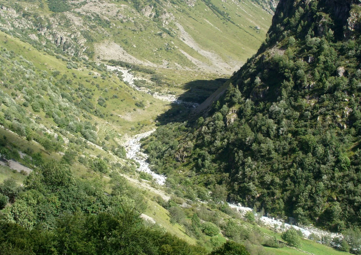
A high-angle view of a mountain valley in the French Alps, featuring a rushing white water river winding between steep green slopes covered in trees and shrubs.
The Séveraisse river flowing through the upper Valgaudemar valley in the French Alps.

Réserve naturelle nationale de la haute vallée de la Séveraisse history and protected-area timeline

The reserve was formally established on 15 May 1974 through French decree number 74-540, which classified several contiguous sites around the edges of the Parc national des Écrins as protected nature reserves. The Haute vallée de la Séveraisse was one of four reserves created simultaneously by this same process, along with the high valleys of the Vénéon, the Béranger, and Saint-Pierre.

The purpose of this group of reserves was explicitly to act as buffer zones, transitional belts of stricter protection that complement the larger but more permissive land-use framework of the Écrins National Park. By protecting the lower-elevation tributary valleys that lie just outside the park's core area, these reserves extend ecological safeguards deeper into the drainage basin of the Oisans-Champsaur region.

Since its creation, the reserve has continued to be administered directly by the Parc national des Écrins, which manages it as an integrated component of its broader conservation strategy in the southern Alps. The foundation decree remains its principal founding legal act, and the reserve has kept its original narrow valley footprint.

Réserve naturelle nationale de la haute vallée de la Séveraisse landscape and geographic character

The reserve occupies a tightly constrained stretch of the upper Séveraisse valley, defined by the river, its alluvial corridor, and the surrounding rocky walls. Its approximate rectangular shape, roughly four kilometers long and only about 0.7 kilometers wide, traces the natural axis of the valley running roughly east to west.

Elevation within the reserve ranges from about 1,150 meters at its lowest point to about 1,600 meters at its highest, placing it squarely in a mid-montane altitudinal band. Above this corridor, the steep slopes of the Valgaudemar rise toward higher alpine terrain, while to the north the Pic du Lauzon dominates the skyline and influences the valley's microclimate, drainage, and visual character. The peripheral rocky zones included in the protected area provide the structural variety that distinguishes the reserve from a simple linear river corridor, adding cliffs, talus, and exposed rock habitats alongside the alluvial bottomland.
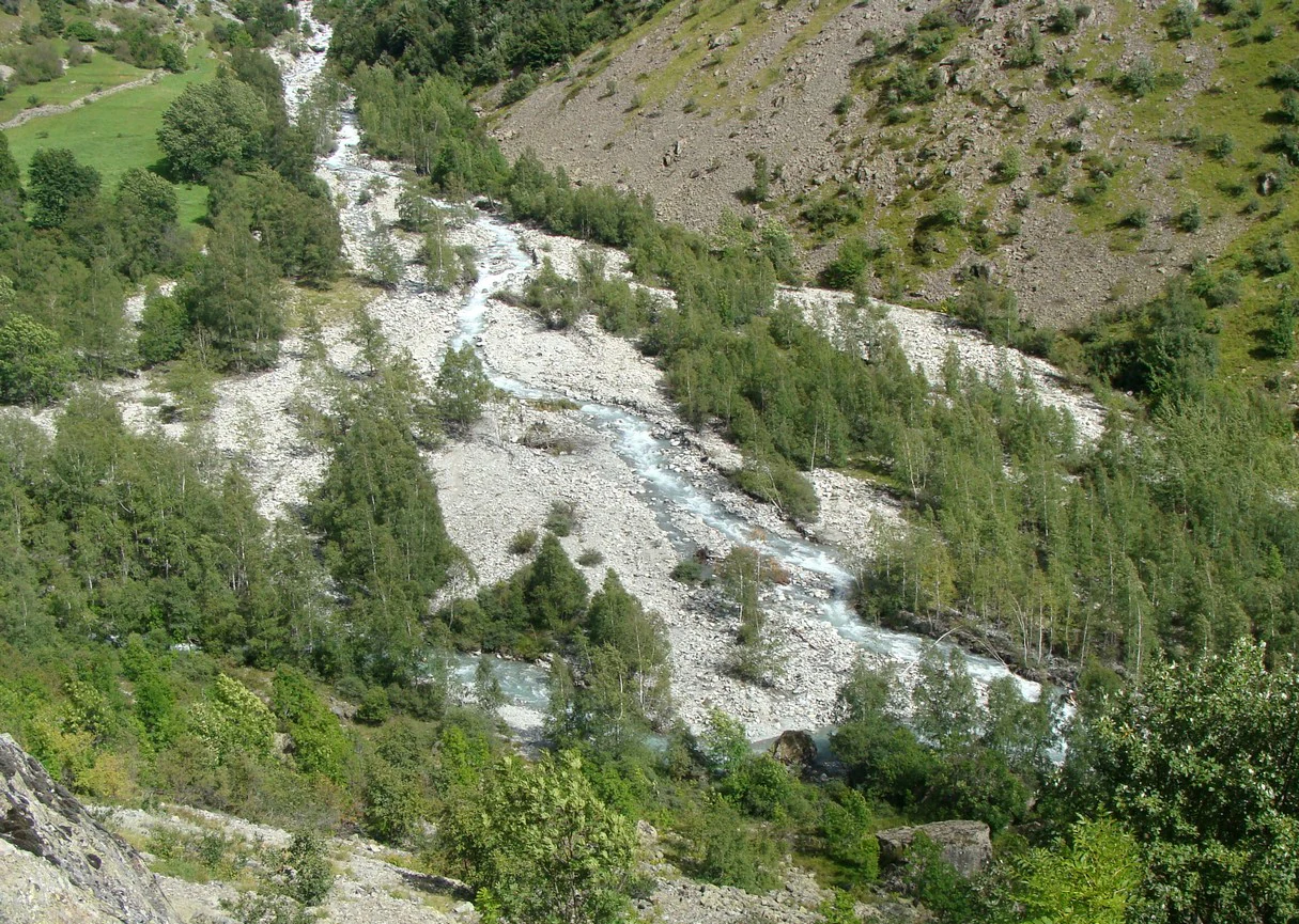
An aerial view of a mountain river flowing through a rocky, tree-lined valley in the Haute Vallée de la Séveraisse.
The confluence of the Séveraisse river and the Gioberney torrent.

Réserve naturelle nationale de la haute vallée de la Séveraisse ecosystems, habitats, and plant life

Ecologically, the reserve is a textbook example of an Alpine riverine corridor at moderate elevation. Its core habitat is the riparian strip along the Séveraisse, where alder woodland forms the characteristic streamside vegetation, with additional herbaceous layers beneath and along the banks. The river itself, along with its gravelly bed and active floodplain, forms the central ecological axis of the protected area.

The reserve's botanical interest is strongly linked to this riverine setting. Beyond the dominant alders, the flora includes several heritage species of note: Gagea fragifera (the Gagée de Liotard), the mealy primrose, and the Piedmont primrose. These species reflect the particular microclimatic conditions found along the Séveraisse, where cool, moist conditions and disturbed alluvial substrates create favorable habitats for specialist plants.

Around the riparian core, the rocky peripheral zones add a different ecological flavor, supporting distinct plant communities on thin soils and offering transition habitats between the riverside forest and the higher slopes above. The combination of flowing water, riparian woodland, and rocky slopes makes the reserve ecologically compact yet structurally diverse.

Réserve naturelle nationale de la haute vallée de la Séveraisse wildlife and species highlights

The animal life of the reserve reflects the mixing of mid-elevation riverine habitats with adjacent rocky alpine slopes. Mammal diversity is modest in species count but ecologically meaningful: the documented mammal fauna includes about 14 species, with chamois and the Alpine marmot as the most emblematic large terrestrial species, both well adapted to the steep terrain and cliff-rich surroundings of the Séveraisse valley.

Birds are a particular strength of the reserve. About 44 breeding bird species have been recorded within its boundaries, including two particularly notable species: the rock partridge, a specialist of steep, rocky Alpine slopes, and the wallcreeper, a rare and dramatic cliff-nesting species closely associated with gorges and crags of the kind found along the Séveraisse. Together, they give the protected area considerable ornithological value relative to its small size.

Reptile diversity is more limited, with two recorded species, but the invertebrate fauna adds a distinctive element through taxa such as the mountain cicada, an unusual insect whose presence emphasizes the transitional, mid-altitude character of the reserve. Taken as a whole, the wildlife of the reserve is shaped by the close interplay between water, woodland, and rock that defines the Séveraisse valley.

Réserve naturelle nationale de la haute vallée de la Séveraisse conservation status and protection priorities

The reserve matters principally as part of the Ecologically Protected Area (EPA) network that strengthens the southern flank of the Écrins National Park. By locking in protection of the upper Séveraisse valley, it ensures that one of the key tributary corridors feeding into the larger Écrins ecosystem is shielded from incompatible land use, helping preserve water quality, riparian connectivity, and habitat continuity in a highly sensitive drainage.

Its IUCN Category IV status, combined with French national nature reserve designation, signals that the area is managed primarily for the conservation of particular habitats and species rather than for large-scale ecosystem processes. This makes the reserve especially relevant for protecting the narrow but high-value habitats along the river and its banks, as well as the cliff zones that support species such as the wallcreeper and rock partridge.

The reserve's integration into the management perimeter of the Écrins National Park adds to its conservation robustness: it benefits from the institutional capacity, monitoring, and ranger network of a major national park, even though legally it remains a separate, more strictly regulated reserve. This dual character, as both a standalone national nature reserve and a buffer of the Écrins, is the central feature of its conservation identity.

Réserve naturelle nationale de la haute vallée de la Séveraisse cultural meaning and human context

The reserve lies within the commune of La Chapelle-en-Valgaudemar, deep in the traditionally Alpine Valgaudemar valley, a part of the French Alps historically shaped by mountain agriculture, transhumance, and small dispersed hamlets. Although the protected area itself focuses on natural values rather than human heritage, its setting is unmistakably that of a long-inhabited Alpine valley.

The presence of the Refuge du Clot - Xavier Blanc within the reserve boundary reflects this longer human relationship with the Séveraisse valley: mountaineering, pastoralism, and refuge-based trekking have long characterized the Valgaudemar, and the reserve overlays a cultural landscape of paths, traditional summer pastures, and shelter networks rather than untouched wilderness.

Top sights and standout views in Réserve naturelle nationale de la haute vallée de la Séveraisse

The reserve's most distinctive feature is its role as a tightly defined, high-altitude river corridor reserve acting as a buffer for the Écrins National Park, alongside three sister reserves in the Vénéon, Béranger, and Saint-Pierre valleys.

Botanically, it concentrates protection on a small but well-defined streamside community of alder woodland and notable specialist plants, including Gagea fragifera and two rare primrose species. Faunistically, the reserve punches above its size thanks to its breeding bird community, where rock partridge and wallcreeper stand out, alongside chamois, marmots, and the unusual mountain cicada.

Best time to visit Réserve naturelle nationale de la haute vallée de la Séveraisse

The reserve sits in a mid-elevation Alpine setting between roughly 1,150 and 1,600 meters, so planning around the mountain seasons is important. Conditions are most comfortable for hiking and observation from late spring through early autumn, when the snow-free window typically opens along the Séveraisse valley and the refuge within the reserve becomes a realistic stop on longer routes.

In summer, the river corridor is at its most accessible, with the riparian woodland in full leaf and the rocky slopes offering good vantage points for viewing chamois, marmots, and cliff-nesting birds such as the wallcreeper. Outside these months, snow and cold conditions at this elevation significantly restrict access and the riverine habitat is largely dormant.

Monthly climate preview

Long term representative point measurements detailing monthly temperature swings and precipitation distribution

Annual Climate Normals and Temperature Rhythms for Réserve naturelle nationale de la haute vallée de la Séveraisse

Representative coordinate records show severe subzero winter averages shifting to mild summer maximums alongside steady year-round precipitation rates. Examining the full twelve month climatology dataset reveals deeper monthly patterns across this protected high-elevation terrain.
Annual mean2 °C
-7 °C12 °C
Jan-7°
Feb-7°
Mar-3°
Apr
May
Jun10°
Jul12°
Aug12°
Sep
Oct
Nov-2°
Dec-6°
Warmest month
August

12.4 °C

Coolest month
January

-7.1 °C

Wettest month
November

3 mm/day

Driest month
March

1.9 mm/day

Park location guide

Geography guide, regional context, and park location map for Réserve naturelle nationale de la haute vallée de la Séveraisse

Réserve naturelle nationale de la haute vallée de la Séveraisse park geography, regions, and map view in France

Understand where Réserve naturelle nationale de la haute vallée de la Séveraisse sits in France through a broader geographic reading of the surrounding landscape, nearby location context, and its mapped position within the national park landscape.

How Réserve naturelle nationale de la haute vallée de la Séveraisse fits into France

France is a unitary semi-presidential republic and one of the world's largest economies. It borders Belgium, Luxembourg, Germany, Switzerland, Italy, Monaco, Andorra, and Spain, with a maritime border to the United Kingdom. The country is known for its cultural influence, art, cuisine, and political history spanning centuries.

Wider geography shaping Réserve naturelle nationale de la haute vallée de la Séveraisse in France

France is located in Western Europe. Metropolitan France extends from the Rhine to the Atlantic Ocean and from the Mediterranean Sea to the English Channel and North Sea. The country borders Belgium, Luxembourg, Germany, Switzerland, Italy, Monaco, Andorra, Spain, and has a maritime border with the United Kingdom.

Map view of Réserve naturelle nationale de la haute vallée de la Séveraisse

Use this park location map to pinpoint Réserve naturelle nationale de la haute vallée de la Séveraisse in France, understand its exact geographic position, and read its mapped placement within the surrounding landscape more clearly.

Pigeon | © OpenStreetMap contributors

Location context for Réserve naturelle nationale de la haute vallée de la Séveraisse

Provence-Alpes-Côte d'Azur

Exploring the protected alpine river landscapes, riparian habitats, and dramatic mountain terrain

Visualizing Réserve naturelle nationale de la haute vallée de la Séveraisse Photos and Scenery

Visual documentation captures the high-mountain river corridor, rocky peripheral slopes, and streamside alder woodland defining the protected valley. Photographic records provide clear geographical context on the alpine ecosystems and dramatic terrain characterizing the natural reserve.

A high-angle view of a mountain valley in the French Alps, featuring a rushing white water river winding between steep green slopes covered in trees and shrubs.

A wallcreeper bird with grey feathers and vivid red patches on its wings, standing on a light-colored rocky surface.

An aerial view of a mountain river flowing through a rocky, tree-lined valley in the Haute Vallée de la Séveraisse.

Park atlas

Compare nearby mountain reserves and connected regional protected landscapes across the French Alps

Parks near Réserve naturelle nationale de la haute vallée de la Séveraisse and surrounding Alpine protected areas

Browse nearby national nature reserves and protected alpine corridors situated throughout the surrounding French mountain region. Continuing beyond Réserve naturelle nationale de la haute vallée de la Séveraisse reveals broader regional topography and connected conservation landscapes.
Watercolor illustration showing mountains, a winding river, and pine trees in a landscape
National parkFrance
Mapped location lies within the park boundary#1 closest

North

Écrins National Park: Alpine Glaciated Terrain and Protected Landscape Details

Mapped boundaries and regional geography of a major French National Park.

Delve into Écrins National Park, a defining national park within the French Alps. This page provides a comprehensive overview of its protected landscape, focusing on its dramatic glaciated terrain, significant peaks such as the Barre des Écrins, and its position within the regional geographic context. Explore the mapped extent and understand the unique alpine environment of this protected area.

Area
925 km²
Established
1973
IUCN
II
Visitors
800K annual
A watercolor illustration of a landscape with purple and pink layered mountain peaks in the background and soft green trees in the foreground, set against a plain white background.
Nature reserveAuvergne-Rhône-Alpes
About 12 km away#2 closest

North

Réserve naturelle nationale de la haute vallée du Vénéon: Alpine Geography and Protected Boundaries

High-altitude mountain terrain in the French Alps

The Réserve naturelle nationale de la haute vallée du Vénéon occupies 61 hectares of striking alpine terrain near the hamlet of La Bérarde. Its landscape of steep slopes and glacial deposits functions as a key protected buffer zone, supporting diverse flora and fauna within the broader mountainous geography of the Auvergne-Rhône-Alpes region.

Area
0.61 km²
Established
1974
IUCN
IV
A soft watercolor illustration featuring rolling green hills, a winding path, and distant mountain ridges in a muted, painterly style.
Nature reserveFrance
About 17 km away#3 closest

Northwest

Réserve naturelle nationale de la haute vallée du Béranger: Mountain Protected Area Map

Tracing the alpine terrain and torrent corridors in the French Alps.

Covering roughly 84 hectares in the Isère region, this nature reserve integrates traditional pastoral landscapes with steep-sided forest slopes and rocky alpine ridges. It functions as a key protective buffer for the larger Écrins National Park, preserving a representative slice of southern French Alpine geography within a single, cohesive valley setting.

Area
0.84 km²
Established
1974
Relief
Mountain
Climate
Alpine
A watercolor painting on a white background showing a landscape with rolling green hills, a small lake, and distant mountain ridges in shades of pink, purple, and green.
Nature reserveProvence-Alpes-Côte d'Azur
About 24 km away#4 closest

East

Réserve naturelle régionale des Partias: Alpine Geography and Protected Nature Reserve Data

High-altitude mountain terrain in the southern French Alps

Covering slopes west of Briançon, Réserve naturelle régionale des Partias protects a layered alpine environment ranging from forested basins to rocky crests. This atlas entry provides a detailed geographic overview of the protected area, focusing on its distinctive mountain lakes, diverse soil substrates, and essential role in conserving alpine ecosystems.

Area
8.018 km²
Established
2009
IUCN
IV
Relief
Mountain
A pale, soft watercolor illustration showing a horizontal landscape of a pond and wetlands bordered by trees, with faint mountain silhouettes in the distance.
Nature reserveIsère
About 52 km away#5 closest

Northwest

Réserve naturelle régionale de l'étang de Haute-Jarrie, Isère Protected Wetland Landscape

Regional nature reserve and migratory bird sanctuary

Situated on the Plateau de Champagnier in Isère, this regional nature reserve offers a concentrated example of glacial pond ecology and wetland biodiversity. Covering 11 hectares, it acts as a critical stopover within the Grésivaudan valley migratory corridor. This protected site features diverse habitats, including reedbeds and wet meadows, that support hundreds of recorded bird species and a variety of dragonflies and amphibians, making it a significant area for ecological study.

Area
0.11 km²
Established
2008
IUCN
IV
Relief
Upland
A soft watercolor painting depicting a winding river through a lush green valley with distant hills in the background.
Nature reserveAuvergne-Rhône-Alpes
About 52 km away#6 closest

Northwest

Réserve naturelle régionale des Isles du Drac: Braided River Landscape and Regional Map Context

A vital riverine conservation corridor in the Auvergne-Rhône-Alpes region of France

The Réserve naturelle régionale des Isles du Drac occupies an expansive alluvial floodplain where the river transitions into a braided system. This reserve preserves dynamic gravel bars and woodland habitats that support exceptional biodiversity within the northern Alpine landscape. It offers a detailed look at how riverine corridors persist alongside significant hydroelectric and industrial infrastructure in the Grenoble area.

Area
8.048 km²
Established
2009
IUCN
IV
Relief
Lowland
Watercolor painting depicting mountains, a river, and trees under a light sky
National parkSavoie
About 53 km away#7 closest

Northeast

Vanoise National Park: Explore France's Original National Park in the Savoie Alps

Mapped Alpine geography, glacial terrain, and protected landscape.

Vanoise National Park is France's pioneering national park, a protected landscape of immense alpine beauty situated in the Savoie department. Renowned for its dramatic glacial terrain, over 100 peaks above 3,000 meters, and the iconic Alpine ibex, this park offers a profound geographic context. Explore its mapped boundaries and discover the unique atlas-level insights into France's mountainous protected areas and their ecological significance.

Area
534 km²
Established
1963
IUCN
II
Relief
Mountain
Watercolor illustration of a mountainous landscape featuring a river, rolling hills, and green vegetation
National parkFrance
About 63 km away#8 closest

Southeast

Mercantour National Park: Mapped Alpine Protected Landscape and Regional Geography

Explore France's dramatic Alps, park boundaries, and unique ecotones.

Mercantour National Park stands as a premier protected area within the French Alps, distinguished by its remarkable geographic diversity and ecological significance. This national park encompasses mountainous terrain featuring dramatic peaks, deep glacial valleys, and a unique ecotone where Mediterranean and Alpine ecosystems converge. MoriAtlas facilitates a detailed atlas-style exploration of Mercantour National Park, highlighting its mapped protected boundaries, varied natural landscapes, and its pivotal role in regional geography and conservation efforts.

Area
679 km²
Established
1979
IUCN
II
Visitors
800K annual

Common questions about visiting, size, designation, and location context for Réserve naturelle nationale de la haute vallée de la Séveraisse

Réserve naturelle nationale de la haute vallée de la Séveraisse FAQs for park facts, access, geography, and protected area context

Find quick answers about Réserve naturelle nationale de la haute vallée de la Séveraisse, including protected-area facts, park geography, trail and visitor context, and how the park fits into its surrounding country and regional landscape.
MoriAtlas Explorer

Continue Your Protected Areas Search Across the Global Atlas

Deepen your exploration by continuing the structured search for national parks and protected areas worldwide. Utilize the comprehensive filtering capabilities to compare different conservation landscapes and refine your understanding of global park geography. Discover more about the distribution and characteristics of protected natural areas.

Global natural geography