
Mori Atlas logo
Nature reserveRéserve naturelle régionale de la côte de Mancy

Mapping the ecological density and distinct calcareous grasslands of the Revermont escarpment zone

Réserve naturelle régionale de la côte de Mancy: A Protected Limestone Landscape in Jura, France

The Réserve naturelle régionale de la côte de Mancy stands as a compact, ecologically dense protected area located in the Jura department of Bourgogne-Franche-Comté. Rising as a north-south limestone hillside, or coteau, above Lons-le-Saunier, the reserve safeguards a complex mosaic of calcareous grasslands, marl, cliffs, and scree. This landscape supports a high concentration of reptiles, orchids, and endemic lepidopterans, serving as a vital fragment of the traditional agro-sylvo-pastoral terrain within the Revermont.

limestone grasslandscalcareous coteaubutterfliesreptilesorchidsbats
A flat-style digital illustration depicting a rural landscape with rolling green hills, scattered trees, and a sunrise with a pink sun behind distant slopes.

Réserve naturelle régionale de la côte de Mancy

Nature reserve

Park overview

Structured park overview, official facts, and landscape profile for Réserve naturelle régionale de la côte de Mancy

Réserve naturelle régionale de la côte de Mancy park facts, protected area profile, and essential visitor context

Review the core facts for Réserve naturelle régionale de la côte de Mancy, including designation, size, terrain, visitor scale, habitats, and operating context in one park-focused overview.

About Réserve naturelle régionale de la côte de Mancy

The Réserve naturelle régionale de la côte de Mancy occupies a narrow limestone hillside in the Jura department, between the communes of Lons-le-Saunier and Macornay. About 1.5 kilometres long from north to south, the coteau runs along the western edge of the Revermont and rises above Lons-le-Saunier and the mouth of the Vernantois reculée. Its compact surface of roughly 49 hectares and its position within an escarpment landscape dominated by the Jura's external overthrust front make it a characteristic fragment of the southern Revermont's natural heritage.

The reserve's ecological interest lies in the diversity of dry, open habitats concentrated in a very small area. Calcareous and marly grasslands form its core, framed by scrub, rocky outcrops, scree, and surrounding woodlands. Together they create seven habitats of community interest, an unusually high diversity for a reserve of this size. The hillside also borders old limestone quarries, and the southern part of the reserve still contains rock-climbing routes, illustrating how former extractive land use has merged into a landscape now valued primarily for its biodiversity.

The côte de Mancy is closely associated with traditional agro-sylvo-pastoral management, and much of its ecological value stems from the past and ongoing maintenance of those practices. Today, the Conservatoire d'espaces naturels de Franche-Comté and Jura Nature Environnement maintain the open character of the site using Konik polski horses and a flock of Thônes et Marthod sheep, preventing encroachment by scrub and woodland. The reserve is open to the public on foot, with dogs kept on lead, making it both a protected ecological site and an accessible place to experience the dry limestone landscapes of the Jura.

Quick facts and research context for Réserve naturelle régionale de la côte de Mancy

The reserve is a Regional Nature Reserve (Réserve naturelle régionale, IUCN Category IV) classified on 12 February 2010 for a renewable period of ten years. It lies on the communes of Lons-le-Saunier and Macornay, at elevations between roughly 280 m and 415 m, covering about 49 hectares. Its surface sits within the Revermont landscape, near the Vernantois reculée and only a couple of kilometres from the Grotte de Gravelle national nature reserve. The protected area is administered by the Conservatoire d'espaces naturels de Franche-Comté together with Jura Nature Environnement and is also recognised as a ZNIEFF of type I and a Special Area of Conservation (ZSC) under the name Côte de Mancy.

Protection and recognition

Review documented terrestrial protection scope and official database identifiers for this protected area.

Réserve naturelle régionale de la côte de Mancy Protection Status and Regional Designation Records

Examine documented protection metrics, designation parameters, and management framework records for Réserve naturelle régionale de la côte de Mancy. Access verified conservation listings, spatial scope indicators, and international database identifiers associated with this site.

Protection details

Protection scope
Terrestrial
Transboundary protection
No
WDPA ID
555514367
Park context

Deeper park guide and search-rich context for Réserve naturelle régionale de la côte de Mancy

Réserve naturelle régionale de la côte de Mancy history, landscape, wildlife, and travel context

Explore Réserve naturelle régionale de la côte de Mancy through its history, landscape character, ecosystems, wildlife, conservation priorities, cultural context, and seasonal travel timing in a structured park guide built for atlas discovery and search intent.

Why Réserve naturelle régionale de la côte de Mancy stands out

The reserve is best known for its combination of calcareous grasslands, cliffs, and scrub that support an exceptional concentration of butterflies and reptiles, including endemic lepidopterans that first drew entomologists' attention in the second half of the twentieth century. These dry, sun-exposed habitats, set within a hillside landscape shaped by historical collective grazing, give the site a distinct identity among regional nature reserves in the Jura. The richness of orchids, butterflies, bats, breeding birds, and reptiles packed into such a small area reinforces its standing as a biodiversity hotspot of local and regional importance.
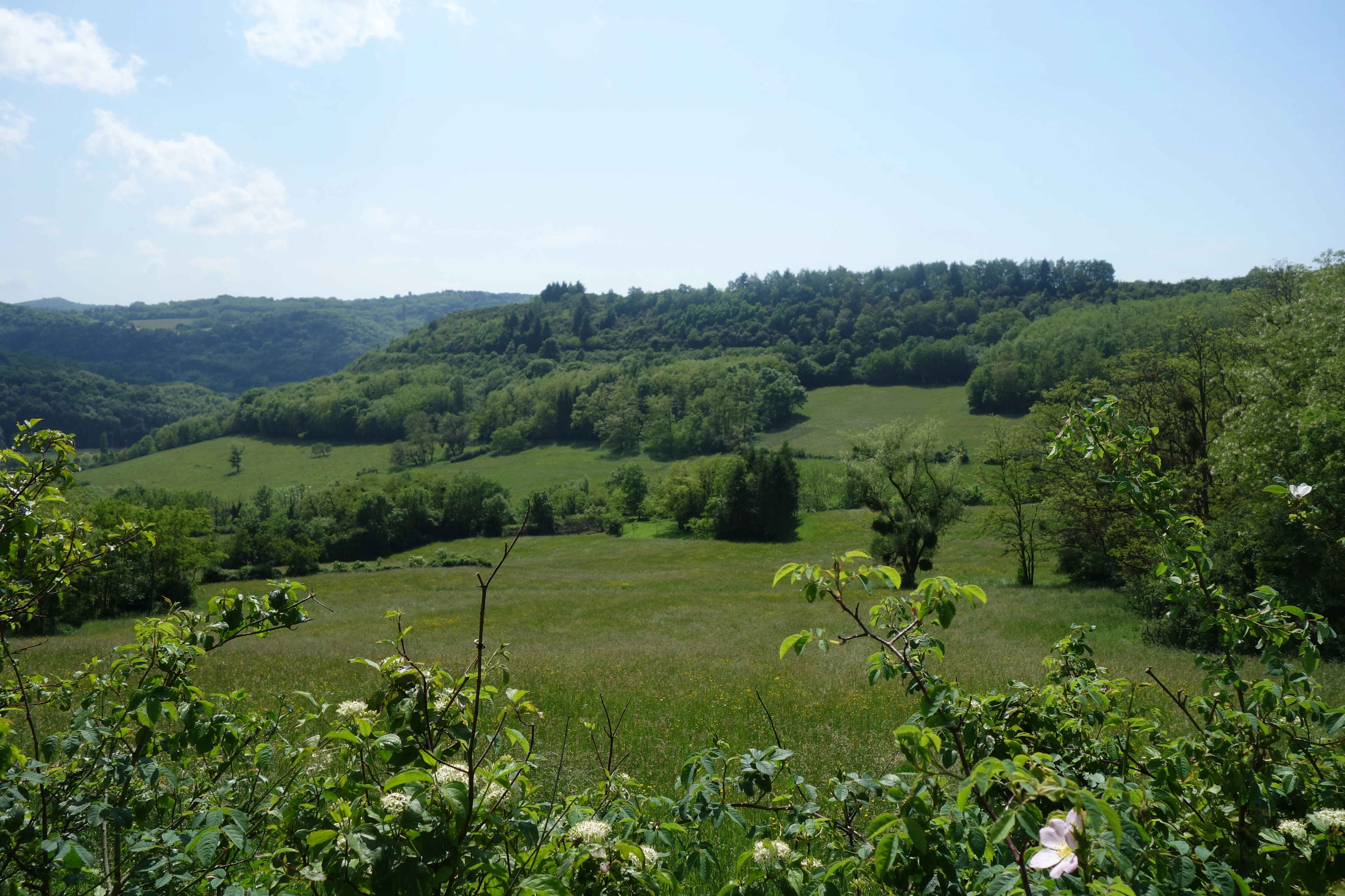
A wide landscape view of rolling green meadows leading to a forested ridge under a blue sky.
A wide view of the rolling green hills and meadows of the Côte de Mancy Regional Nature Reserve.

Réserve naturelle régionale de la côte de Mancy history and protected-area timeline

The hillside of Mancy has a long history as a communally managed space, with traditional agro-sylvo-pastoral techniques shaping its grasslands, scrub, and woodlands. These land uses created and sustained habitats that later became rare both in extent and in number. In the second half of the twentieth century, entomologists highlighted the site for its endemic lepidopterans, a discovery that drew scientific attention to its exceptional biodiversity value.

The plateau of Mancy was first classified as a voluntary nature reserve (réserve naturelle volontaire) in 1996, formalising early efforts to protect its habitats. On 12 February 2010, the site was reclassified as a regional nature reserve for a renewable period of ten years, giving it a stronger legal framework. It has since been incorporated into regional and European ecological inventories, being included in a ZNIEFF of type I (no. 00000028) and in the Natura 2000 ZSC FR4302001 Côte de Mancy.

Réserve naturelle régionale de la côte de Mancy landscape and geographic character

The reserve's landscape is defined by a north-south oriented limestone coteau forming part of the Revermont, an escarpment zone that marks the leading edge of the Jura's external overthrust onto the Bresse plain. Elevations range from about 278 metres to 415 metres, with the hillside overlooking Lons-le-Saunier and framing the entrance to the Vernantois reculée to the south.

Geologically, the site sits on Jurassic limestones of Bajocian age, with Toarcian and Aalenian layers also visible at the surface. Old limestone quarries along its edge, combined with cliffs, scree, and rocky outcrops, give the coteau a rugged, varied relief. This combination of steep slopes, exposed rock, and thin calcareous soils has produced a mosaic of dry grasslands, scrub, and woody fringes that visually distinguishes the reserve from the agricultural lowlands and vineyards of the surrounding area.

Réserve naturelle régionale de la côte de Mancy ecosystems, habitats, and plant life

Ecologically, the côte de Mancy is dominated by dry calcareous and marly grasslands, supplemented by scrub communities, rock faces, scree slopes, and peripheral woodlands. Seven habitats of community interest, recognised under the European Habitats Directive, are present within the reserve, a remarkable concentration given the site's small size.

The flora reflects this habitat diversity. Around 482 species of spermatophytes have been recorded, including four regionally protected species and one regional red-list species, the Baguenaudier. Several orchid species, such as the Monkey orchid, the Bee orchid, and the Spider orchid, sit at the threshold of regional red-list status. The site also supports nine liverwort species, 105 mosses, and eight ferns. Fungi and lichens are similarly diverse, with 229 fungi and 48 lichen species recorded by the end of 2022. The combination of open dry grasslands, cliffs, scree, and scrub creates the layered habitat structure that underpins the reserve's biodiversity value.

Réserve naturelle régionale de la côte de Mancy wildlife and species highlights

The reserve is renowned for its invertebrat and reptile fauna, particularly its lepidopterans. Endemic butterflies were the first group to attract scientific interest, and the dry calcareous and marly habitats continue to support a rich community of these insects. Reptiles are equally notable, with ten of the twelve reptile species recorded in Franche-Comté present on the site, including the Slow worm, the Viperine snake, the Grass snake, the Asp viper, and the Western green lizard.

The site also shelters a diverse bat community, with 18 species recorded, including the Schreibers' bat, the Common pipistrelle, the Lesser mouse-eared bat, and the Greater mouse-eared bat. Birdlife is well documented, with a permanent inventory listing 121 species, of which 49 are considered to breed at the site. Among the breeding and regularly recorded species are the Woodlark, the Red-backed shrike, the Lesser spotted woodpecker, the Black woodpecker, the European honey buzzard, the Black kite, and the Red kite, reflecting the value of the wooded fringes as well as the open slopes.

Réserve naturelle régionale de la côte de Mancy conservation status and protection priorities

The côte de Mancy is significant for conservation because it concentrates a high number of priority habitats and species into a very small area, acting as a local refuge for several rare or endemic taxa. Its seven habitats of community interest and the presence of endemic lepidopterans, regionally protected plants, and a large share of Franche-Comté's reptile fauna underline its biodiversity importance well beyond its modest size.

Protection operates on multiple, overlapping levels. The site is a regional nature reserve, a ZNIEFF of type I, and a Special Area of Conservation (ZSC FR4302001 Côte de Mancy) under the European Natura 2000 network. Management by the Conservatoire d'espaces naturels de Franche-Comté and Jura Nature Environnement, supported by grazing with Konik polski horses and Thônes et Marthod sheep, is designed to maintain the open habitats that depend on continued pastoral activity. Without this, the reserve's rare grasslands and the species tied to them would risk being lost to scrub encroachment and ecological fragmentation.

Réserve naturelle régionale de la côte de Mancy cultural meaning and human context

The reserve embodies a long tradition of collective agro-sylvo-pastoral land use on what was once a communal space. These traditional techniques shaped a landscape of calcareous grasslands, scrub, and woodlands, and their later partial abandonment, combined with residual pastoral management, helped create the mosaic of habitats that make the site ecologically valuable today. The côte de Mancy therefore illustrates how centuries of human activity and nature conservation can become closely intertwined in the southern Revermont.

Top sights and standout views in Réserve naturelle régionale de la côte de Mancy

Within only about 49 hectares, the reserve combines seven habitats of community interest with endemic butterflies, ten regional reptile species, eighteen bat species, and more than 120 recorded bird species. Traditional grazing by Konik polski horses and Thônes et Marthod sheep continues to maintain its open limestone grasslands, and the same hillside confines old quarries, cliffs, scree, and scrub in close proximity. As both a ZNIEFF and a Natura 2000 Special Area of Conservation, the côte de Mancy demonstrates how a small site can carry a disproportionately large share of regional biodiversity.

Best time to visit Réserve naturelle régionale de la côte de Mancy

The coteau is accessible on foot throughout the year, with dogs required to be kept on lead. Late spring and early summer are especially appealing for visitors interested in orchids and butterflies, when calcareous grasslands come into bloom and many of the lepidopteran species associated with the site are most active. Warm, sunny days in late spring and summer also offer the best chances of observing reptiles on the dry, rocky slopes. Autumn highlights the fungi and lichens for which the reserve has an ongoing inventory, while winter and early spring reveal the open structure of the grasslands maintained by extensive grazing.
Monthly climate preview

Long term representative temperature and precipitation averages recorded across twelve months

Réserve naturelle régionale de la côte de Mancy Climate Normals and Annual Weather Patterns

Historical climatology data reveals measured monthly temperature ranges and steady precipitation distributions across the protected landscape. Examining the complete twelve month profile provides detailed context on long term thermal swings and moisture patterns.
Annual mean9 °C
0 °C19 °C
Jan
Feb
Mar
Apr
May13°
Jun16°
Jul19°
Aug19°
Sep14°
Oct10°
Nov
Dec
Warmest month
July

18.6 °C

Coolest month
January

0.1 °C

Wettest month
December

3.9 mm/day

Driest month
March

2.8 mm/day

Park location guide

Geography guide, regional context, and park location map for Réserve naturelle régionale de la côte de Mancy

Réserve naturelle régionale de la côte de Mancy park geography, regions, and map view in France

Understand where Réserve naturelle régionale de la côte de Mancy sits in France through a broader geographic reading of the surrounding landscape, nearby location context, and its mapped position within the national park landscape.

How Réserve naturelle régionale de la côte de Mancy fits into France

France is a unitary semi-presidential republic and one of the world's largest economies. It borders Belgium, Luxembourg, Germany, Switzerland, Italy, Monaco, Andorra, and Spain, with a maritime border to the United Kingdom. The country is known for its cultural influence, art, cuisine, and political history spanning centuries.

Wider geography shaping Réserve naturelle régionale de la côte de Mancy in France

France is located in Western Europe. Metropolitan France extends from the Rhine to the Atlantic Ocean and from the Mediterranean Sea to the English Channel and North Sea. The country borders Belgium, Luxembourg, Germany, Switzerland, Italy, Monaco, Andorra, Spain, and has a maritime border with the United Kingdom.

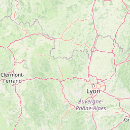
Map view of Réserve naturelle régionale de la côte de Mancy

Use this park location map to pinpoint Réserve naturelle régionale de la côte de Mancy in France, understand its exact geographic position, and read its mapped placement within the surrounding landscape more clearly.

Pigeon | © OpenStreetMap contributors

Location context for Réserve naturelle régionale de la côte de Mancy

Bourgogne-Franche-Comté

Visualizing the limestone grasslands, cliffs, and protected habitats of the Revermont escarpment

Réserve naturelle régionale de la côte de Mancy Photos and Scenery

Visual records capture the limestone coteau, rocky outcrops, and diverse calcareous habitats defining Réserve naturelle régionale de la côte de Mancy. Examining these landscape photographs reveals the rugged terrain, dry grasslands, and protected environmental features characterizing the regional reserve.

A wide landscape view of rolling green meadows leading to a forested ridge under a blue sky.

Park atlas

Compare regional limestone landscapes and surrounding protected habitats across eastern France

Explore Protected Areas and Parks Near Réserve naturelle régionale de la côte de Mancy

Visitors exploring Réserve naturelle régionale de la côte de Mancy can continue browsing nearby protected areas and connected regional landscapes. Examining adjacent terrain helps place local calcareous habitats, escarpments, and wildlife reserves into a broader geographic context.
Nature reserveBourgogne-Franche-Comté
About 2.1 km away#1 closest

South

Réserve naturelle nationale de la grotte de Gravelle: Underground Protected Nature Reserve

A limestone cave sanctuary in the Bourgogne-Franche-Comté region

This protected area represents a specialized subterranean habitat in the French Jura, preserving essential maternity and hibernation roosts for eleven bat species. The reserve, set within forested limestone cliffs, remains a key node in the regional network of protected underground sites, emphasizing the conservation of fragile environments.

Area
0.014 km²
Established
1992
IUCN
IV
Relief
Upland
A horizontal watercolor painting depicting a soft, impressionistic landscape with rolling green hills, pale yellow fields, and a sparse line of trees against a white background.
Nature reserveBourgogne-Franche-Comté
About 24 km away#2 closest

Northeast

Réserve naturelle régionale des grottes de la côte de la Baume, Jura Regional Nature Reserve

Karst caves and cliff-slope forest geography in France

Located in the Bourgogne-Franche-Comté region, this nature reserve protects a vital network of karst caves and unmanaged scree-slope ash forests. The site represents a specialized conservation effort centered on cliff-side habitats and underground sanctuaries within the Jura limestone landscape.

Area
0.054 km²
Established
2017
IUCN
IV
Relief
Upland
Wildlife reserveBourgogne-Franche-Comté
About 26 km away#3 closest

East

Tourbières et lacs de la montagne jurassienne: Mapping High-Altitude Wetlands and Glacial Landscapes

A vast protected wildlife reserve in the Bourgogne-Franche-Comté region

Covering more than 12,000 hectares, this wildlife reserve forms a crucial conservation benchmark for peatland and glacial lake systems in the Jura Massif. The landscape encompasses deep combes, broad plateaus, and clear-water basins like Lac de Saint-Point, providing a vital habitat mosaic for diverse flora and fauna across the French highlands.

Area
121.56 km²
Established
2021
Relief
Mountain
Climate
Temperate
A horizontal watercolor painting depicting a soft, layered landscape with distant hills, gentle slopes, and clusters of evergreen trees in shades of green and purple.
Nature reserveBourgogne-Franche-Comté
About 28 km away#4 closest

Southeast

Réserve naturelle régionale des tourbières du bief du Nanchez: Protected Jura Mountain Peatlands

Mapping bog systems and wet grassland geography in Eastern France

Located in the Jura department, this regional nature reserve preserves forty-nine hectares of vital peatland, including diverse mire communities and forested slopes. The site provides a critical look at montane landscape restoration, documenting significant bog flora and complex hydrological patterns along the Combe du Nanchez valley floor.

Area
0.488 km²
Established
2021
IUCN
IV
Relief
Upland
Nature reserveAuvergne-Rhône-Alpes
About 44 km away#5 closest

South

Réserve naturelle régionale du récif fossile de Marchon - Christian Gourrat Geological Site

A protected Jurassic fossil reef in the Auvergne-Rhône-Alpes region

Located in the Ain department, this small nature reserve is scientifically renowned for its Kimmeridgian reef outcrop. The site protects a fossilized coral and rudist assemblage within the forêt de Marchon, offering a quiet, forested setting for studying France's ancient marine geological history.

Area
0.001 km²
Established
2015
IUCN
IV
Scope
Terrestrial
A horizontal watercolor painting showing a soft, misty landscape with coniferous trees, grassy wetlands, and rolling hills in the background, executed in a muted color palette.
Nature reserveBourgogne-Franche-Comté
About 47 km away#6 closest

East

Réserve naturelle régionale de la Seigne des Barbouillons Protected Landscape Atlas

Geography and wetland boundaries in the Jura plateau of France

The Réserve naturelle régionale de la Seigne des Barbouillons protects a characteristic raised bog ecosystem in the Mignovillard commune. This compact area serves as a vital reference point for understanding the distribution of sphagnum mires and specialized butterfly habitats across the Jura plateau, illustrating the contrast between protected peatlands and their surrounding agricultural environment.

Area
0.346 km²
Established
2014
IUCN
IV
Relief
Upland
A watercolor illustration of a landscape with green forest, wetland grasses, and pale mountains in the background, set against a clean white background.
Nature reserveBourgogne-Franche-Comté
About 52 km away#7 closest

Northeast

Réserve naturelle régionale des tourbières de Frasne-Bouverans Protected Landscape Atlas

Peatland mosaic geography in the Drugeon valley of Bourgogne-Franche-Comté

Trace the boundaries and ecological features of this significant regional nature reserve. Spanning the Forbonnet massif and the wider Drugeon basin, the area features a dense concentration of raised bogs, woodlands, and mire habitats defined by complex glacial geology.

Area
2.926 km²
Established
1986
IUCN
IV
Visitors
17.5K annual
A soft, panoramic watercolor illustration of rolling hills, mountains, and trees in pastel shades of green, yellow, and pink.
Nature reserveAuvergne-Rhône-Alpes
About 54 km away#8 closest

South

Réserve naturelle nationale de la grotte de Hautecourt: Jura Mountain Cave Geography

Protected subterranean landscapes in the Ain department of France.

This nature reserve protects a complex underground environment characterized by a vertical 36-meter cave system and rich invertebrate biodiversity. Located on the flank of Mont Rosset in the Auvergne-Rhône-Alpes region, the area provides a crucial habitat that balances delicate subterranean passages with surface limestone ridges and dry grassland ecosystems.

Area
0.102 km²
Established
1980
IUCN
IV

Common questions about visiting, size, designation, and location context for Réserve naturelle régionale de la côte de Mancy

Réserve naturelle régionale de la côte de Mancy FAQs for park facts, access, geography, and protected area context

Find quick answers about Réserve naturelle régionale de la côte de Mancy, including protected-area facts, park geography, trail and visitor context, and how the park fits into its surrounding country and regional landscape.
MoriAtlas Explorer

Continue Your Protected Areas Search Across the Global Atlas

Deepen your exploration by continuing the structured search for national parks and protected areas worldwide. Utilize the comprehensive filtering capabilities to compare different conservation landscapes and refine your understanding of global park geography. Discover more about the distribution and characteristics of protected natural areas.

Global natural geography