Mori Atlas logo
Nature reserveRéserve naturelle régionale du Pourra - Domaine du Ranquet

A regional nature reserve protecting coastal lagoons and transitional Mediterranean landscapes in the Bouches-du-Rhône

Réserve naturelle régionale du Pourra - Domaine du Ranquet: Mapping Mediterranean Wetland Geography

Located in the Provence-Alpes-Côte d'Azur region, the Réserve naturelle régionale du Pourra - Domaine du Ranquet safeguards critical coastal wetland ecosystems including the Étang du Pourra and the periphery of the Étang de Citis. This protected landscape encompasses reedbeds, saline margins, and Mediterranean garrigue. The reserve serves as a vital geographic anchor within the complex lagoon network situated between the Rhône delta and the industrial coastline west of Marseille.

wetlandscoastal lagoonMediterraneannature reserveProvence-Alpes-Côte d'AzurBouches-du-Rhône

Réserve naturelle régionale du Pourra - Domaine du Ranquet

Nature reserve

Park overview

Structured park overview, official facts, and landscape profile for Réserve naturelle régionale du Pourra - Domaine du Ranquet

Réserve naturelle régionale du Pourra - Domaine du Ranquet park facts, protected area profile, and essential visitor context

Review the core facts for Réserve naturelle régionale du Pourra - Domaine du Ranquet, including designation, size, terrain, visitor scale, habitats, and operating context in one park-focused overview.

About Réserve naturelle régionale du Pourra - Domaine du Ranquet

The Réserve naturelle régionale du Pourra - Domaine du Ranquet is a protected natural area in the Bouches-du-Rhône department, in the Provence-Alpes-Côte d'Azur region of southern France. Classified on 6 March 2020 by the Conseil régional, the reserve covers roughly 315 hectares across the communes of Port-de-Bouc and Saint-Mitre-les-Remparts. It is registered as RNR324 in the French regional nature reserve network and as IUCN Category IV in international classifications.

The territory is defined by its wetland character. The reserve encircles the Étang du Pourra, a coastal lagoon whose shallow waters and fringing habitats are ecologically important for the Provençal coast, and it extends across the periphery of the neighboring Étang de Citis. Together, these waterbodies form part of the mosaic of étangs and marshes between the industrial and port zones of Fos-sur-Mer and the broader Étang de Berre system.

Geographically, the reserve lies close to the town of Port-de-Bouc and the Gulf of Fos, an area historically shaped by the combination of Mediterranean climate, saline soils, and coastal lagoons. Although the surrounding landscape includes significant industrial and port infrastructure, the reserve preserves pockets of characteristic Mediterranean wetland habitat, including reed-fringed shorelines, salt-influenced vegetation, and the transition zones where aquatic environments meet dry Mediterranean scrubland.

As a regional nature reserve, the Pourra - Domaine du Ranquet is part of France's broader framework of protections managed at the regional level. Its relatively recent creation reflects ongoing efforts to identify and safeguard remaining coastal wetland fragments in Provence, where development pressures have historically affected natural lagoon systems. The reserve's profile is therefore closely linked to both its specific lagoons and its role within the wider network of Mediterranean coastal biodiversity conservation.

Quick facts and research context for Réserve naturelle régionale du Pourra - Domaine du Ranquet

The Pourra - Domaine du Ranquet reserve is a French regional nature reserve (réserve naturelle régionale) covering around 315 hectares in the department of Bouches-du-Rhône. It lies within the Provence-Alpes-Côte d'Azur region, on the communes of Port-de-Bouc and Saint-Mitre-les-Remparts, near the Gulf of Fos and the western edge of the Étang de Berre lagoon system.

Created on 6 March 2020 by a regional council deliberation and catalogued as RNR324, the reserve is classified under IUCN Category IV and is recorded in the World Database on Protected Areas. Its protected perimeter centers on the Étang du Pourra and the periphery of the Étang de Citis, placing its conservation focus squarely on coastal lagoons, their fringing habitats, and the ecological connections between them.

Protection and recognition

Documented protection records and official designation identifiers

Réserve naturelle régionale du Pourra - Domaine du Ranquet Protection Status

Protected area registry records assemble the documented protection status and official database identifiers for Réserve naturelle régionale du Pourra - Domaine du Ranquet. Verified administrative details establish baseline conservation parameters and regulatory context for this natural landscape.

Protection details

WDPA ID
555702231
Park context

Deeper park guide and search-rich context for Réserve naturelle régionale du Pourra - Domaine du Ranquet

Réserve naturelle régionale du Pourra - Domaine du Ranquet history, landscape, wildlife, and travel context

Explore Réserve naturelle régionale du Pourra - Domaine du Ranquet through its history, landscape character, ecosystems, wildlife, conservation priorities, cultural context, and seasonal travel timing in a structured park guide built for atlas discovery and search intent.

Why Réserve naturelle régionale du Pourra - Domaine du Ranquet stands out

The reserve is best known for protecting the Étang du Pourra, a coastal lagoon, and for safeguarding the peripheral habitats around the adjacent Étang de Citis. Both waterbodies lie within the larger Provençal lagoon complex west of Marseille, where brackish and saline waters, reedbeds, and surrounding Mediterranean vegetation form a distinctive coastal wetland mosaic. The reserve's identity is closely tied to the ecological transition area between saline lagoon environments and the dry garrigue and maquis typical of inland Provence. Its relatively recent designation, in 2020, underscores its role as a modern tool for conserving disjunct fragments of Mediterranean coastal habitat that remain amid heavily developed surroundings.

Réserve naturelle régionale du Pourra - Domaine du Ranquet history and protected-area timeline

The Réserve naturelle régionale du Pourra - Domaine du Ranquet is a recently established protected area. It was formally created by a deliberation of the Conseil régional de Provence-Alpes-Côte d'Azur on 6 March 2020, giving the site its current status as a regional nature reserve.

The reserve is catalogued as RNR324 within the French system of regional nature reserves, and it was inscribed in the World Database on Protected Areas under entry 555702231 with an IUCN Category IV designation. Its creation continues the regional approach of identifying and protecting coastal wetland landscapes that have been reduced and fragmented by surrounding land uses, and it represents an ongoing commitment to managing the remaining lagoon habitats of Bouches-du-Rhône under a formal conservation framework.

Réserve naturelle régionale du Pourra - Domaine du Ranquet landscape and geographic character

The reserve's landscape is dominated by coastal lagoons and their immediate surroundings. At its heart lies the Étang du Pourra, a shallow Mediterranean lagoon whose water level and salinity fluctuate with the seasons and with connections to neighbouring waterbodies. The reserve also includes parts of the periphery of the Étang de Citis, extending the protected habitat along the shores of this adjacent lagoon.

Beyond the open water, the terrain comprises reed-fringed shorelines, low-lying marshy margins, and the gradual ecological transition into the dry garrigue and maquis typical of Provence. The presence of halophytic vegetation around the lagoons gives the area a distinctive Mediterranean coastal character, while the broader setting places the reserve within the wider network of étangs between the Rhône delta to the west and the Étang de Berre to the east. The proximity of Port-de-Bouc and surrounding industrial landscapes makes the green wedge of the reserve a notable natural element within an otherwise heavily developed coastline.

Réserve naturelle régionale du Pourra - Domaine du Ranquet ecosystems, habitats, and plant life

The ecological value of the reserve centres on coastal lagoon habitats, which are among the most characteristic and threatened Mediterranean wetland environments. The Étang du Pourra and the peripheral zones of the Étang de Citis provide open water, brackish margins, reedbeds, and surrounding saline-influenced vegetation that together form a mosaic of transitional habitats between fully aquatic and fully terrestrial environments.

These lagoon and shoreline habitats are recognised for supporting biodiversity in a region where natural wetlands have been substantially reduced by coastal development, port infrastructure, and agricultural drainage. The presence of both permanently and seasonally inundated zones creates environmental gradients that foster specialised plant communities as well as the invertebrates, fish, waterbirds, and other fauna that depend on them. The integration of the reserve into the broader Provençal coastal landscape also positions it as a component in the ecological continuity between the Rhône delta wetlands to the west and the Étang de Berre system to the east.

Réserve naturelle régionale du Pourra - Domaine du Ranquet wildlife and species highlights

The reserve's wildlife interest is closely tied to its lagoon environment. The Étang du Pourra and the edges of the Étang de Citis attract waterbirds and shorebirds that rely on Mediterranean coastal lagoons for feeding, resting, and seasonal staging, while the fringing reedbeds and halophytic vegetation provide habitat for a range of invertebrates, small mammals, and fish adapted to saline and brackish conditions.

The wetland mosaic also supports reptile and amphibian communities associated with marshy margins and Mediterranean shrubland transitions, and the reserve's position within the wider coastal ecosystem means its fauna can be understood in the context of other Provençal lagoon sites. Although site-level species detail is not extensively documented, the reserve's ecological value reflects the broader significance of French Mediterranean lagoons as refuges for waterbirds and as productive transitional ecosystems.

Réserve naturelle régionale du Pourra - Domaine du Ranquet conservation status and protection priorities

The creation of the reserve in 2020 reflects the regional strategy of preserving fragments of Mediterranean coastal wetland habitat that remain amid long-developed landscapes. Its IUCN Category IV designation frames it as a habitat and species management area, meaning that active conservation measures can be deployed to maintain or restore the ecological character of the lagoons and their margins.

The reserve helps secure ecological continuity within a chain of coastal wetlands that includes the Rhône delta and the Étang de Berre, linking protected and unprotected stretches of lagoon shoreline. By protecting both the open waters of the Étang du Pourra and the periphery of the Étang de Citis, the reserve addresses two important features simultaneously: the conservation of a discrete lagoon ecosystem and the protection of the transitional zones in which aquatic and terrestrial species interact.

Top sights and standout views in Réserve naturelle régionale du Pourra - Domaine du Ranquet

Among the reserve's most notable qualities is its focus on two interconnected Mediterranean lagoons, the Étang du Pourra and the periphery of the Étang de Citis, both of which are unusual within a heavily developed coastal strip. The reserve also stands out for being among the most recently established regional nature reserves in Provence-Alpes-Côte d'Azur, reflecting ongoing regional commitment to wetland conservation.

The site's position near Port-de-Bouc, between the Gulf of Fos and the interior Provançal landscape, gives it a distinctive geographic character. It is an example of how small protected areas can anchor ecological value within a densely used coastal zone, preserving reedbeds, saline margins, and characteristic Mediterranean vegetation in a setting where such habitats have otherwise been substantially reduced.

Best time to visit Réserve naturelle régionale du Pourra - Domaine du Ranquet

Because the reserve is centered on coastal lagoons within a Mediterranean climate, the cooler and wetter months tend to bring more active waterbird presence and softer light over the water, while late spring and early summer showcase the surrounding garrigue and maquis in bloom. Seasonal water levels in the Étang du Pourra also influence habitat conditions for wildlife.

Visitors interested in Mediterranean wetland landscapes generally find shoulder seasons rewarding, when both lagoon birdlife and surrounding vegetation are active without the heat peaks of high summer. As with any regional nature reserve, on-the-ground access is governed by local management rules.
Monthly climate preview

Long-term representative temperature and precipitation normals across twelve recorded monthly intervals

Climate Normals and Annual Weather Patterns at Réserve naturelle régionale du Pourra - Domaine du Ranquet

Representative coordinate measurements reveal how monthly temperatures and precipitation levels shift across the annual cycle at Réserve naturelle régionale du Pourra - Domaine du Ranquet. Examining the complete twelve-month profile provides granular insight into long-term meteorological normals without relying on short-term forecasts.
Annual mean15 °C
8 °C25 °C
Jan
Feb
Mar11°
Apr14°
May18°
Jun22°
Jul25°
Aug24°
Sep20°
Oct16°
Nov12°
Dec
Warmest month
July

24.6 °C

Coolest month
January

7.6 °C

Wettest month
November

2.6 mm/day

Driest month
July

0.5 mm/day

Park location guide

Geography guide, regional context, and park location map for Réserve naturelle régionale du Pourra - Domaine du Ranquet

Réserve naturelle régionale du Pourra - Domaine du Ranquet park geography, regions, and map view in France

Understand where Réserve naturelle régionale du Pourra - Domaine du Ranquet sits in France through a broader geographic reading of the surrounding landscape, nearby location context, and its mapped position within the national park landscape.

How Réserve naturelle régionale du Pourra - Domaine du Ranquet fits into France

France is a unitary semi-presidential republic and one of the world's largest economies. It borders Belgium, Luxembourg, Germany, Switzerland, Italy, Monaco, Andorra, and Spain, with a maritime border to the United Kingdom. The country is known for its cultural influence, art, cuisine, and political history spanning centuries.

Wider geography shaping Réserve naturelle régionale du Pourra - Domaine du Ranquet in France

France is located in Western Europe. Metropolitan France extends from the Rhine to the Atlantic Ocean and from the Mediterranean Sea to the English Channel and North Sea. The country borders Belgium, Luxembourg, Germany, Switzerland, Italy, Monaco, Andorra, Spain, and has a maritime border with the United Kingdom.

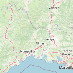
Map view of Réserve naturelle régionale du Pourra - Domaine du Ranquet

Use this park location map to pinpoint Réserve naturelle régionale du Pourra - Domaine du Ranquet in France, understand its exact geographic position, and read its mapped placement within the surrounding landscape more clearly.

Pigeon | © OpenStreetMap contributors

Location context for Réserve naturelle régionale du Pourra - Domaine du Ranquet

Provence-Alpes-Côte d'Azur
Park atlas

Compare connected coastal wetland habitats and regional nature reserves across southeastern France.

Parks near Réserve naturelle régionale du Pourra - Domaine du Ranquet and surrounding protected areas

Browse nearby protected areas and regional nature reserves linked to the wetland landscapes of Réserve naturelle régionale du Pourra - Domaine du Ranquet. Comparing adjacent coastal lagoons and marshland habitats reveals the wider ecological patterns preserved across the Provençal coast.
A horizontal watercolor illustration showing a marshy, grassy landscape with soft green and muted pink tones against a white background.
Regional parkProvence-Alpes-Côte d'Azur
About 9.8 km away#1 closest

West

Parc naturel régional de Camargue: Mapping the Rhône Delta Protected Wetland Landscape

Regional park geography and wetland conservation zones

Parc naturel régional de Camargue is a sprawling protected landscape at the confluence of the Rhône and the Mediterranean. This regional park contains significant saline lagoons, coastal dunes, and fertile marshes that serve as a crucial site for waterbird migration. Understand the interplay between traditional salt-making, pastoral ranching, and the strictly protected nature reserves that shape this delta territory.

Area
856.9 km²
Established
1970
IUCN
V
Relief
Lowland
Nature reserveProvence-Alpes-Côte d'Azur
About 19 km away#2 closest

North

Réserve naturelle régionale de la Poitevine-Regarde-Venir: Steppe Conservation and Geography

Protected dry steppe landscapes in the French Crau region

Delve into the geography of the Réserve naturelle régionale de la Poitevine-Regarde-Venir, a specialized nature reserve that safeguards the distinctive pebbly coussoul of the Crau plain. The area represents a fundamental piece of Mediterranean pastoral history, balancing fragile steppe ecosystems with traditional agricultural meadows.

Area
2.207 km²
Established
2009
IUCN
IV
A watercolor illustration of a tranquil marshland scene with soft green and muted pink tones, depicting reeds, sparse trees, and calm water.
Nature reserveFrance
About 27 km away#3 closest

West

Réserve naturelle régionale de la Tour du Valat: Mediterranean Wetland and Research Landscape Map

A critical protected area and ecological research estate in the Rhône delta of France.

Located in the Bouches-du-Rhône department, the Réserve naturelle régionale de la Tour du Valat serves as a reference point for Mediterranean wetland science. The reserve features an intricate landscape of marshes, salt meadows, and woodland patches that support diverse birdlife and habitats. This protected area demonstrates the integration of active pastoral land use with habitat management on a significant deltaic estate near Arles.

Area
18.44 km²
Established
2008
Relief
Lowland
Climate
Mediterranean
Watercolor illustration of coastal mountains and shoreline with scattered trees
National parkBouches-du-Rhône
About 31 km away#4 closest

Southeast

Calanques National Park: Mediterranean Limestone Cliffs and Marine Protected Area

France's First Peri-Urban National Park

Calanques National Park, situated in the Bouches-du-Rhône department, represents a significant protected landscape where dramatic limestone geology meets the Mediterranean Sea. This atlas-focused entry details the park's iconic calanques, its combined terrestrial and marine protected zones, and its rich prehistoric cultural significance. Understand its unique geographic setting and its importance as a conservation area accessible for map-based discovery and regional landscape context.

Area
520 km²
Established
2012
IUCN
II
Relief
Mountain
A horizontal watercolor painting depicting a soft-focus landscape of grassy wetlands in the foreground with gentle, rolling hills in the background.
Nature reserveProvence-Alpes-Côte d'Azur
About 32 km away#5 closest

Northwest

Réserve naturelle régionale de l'Ilon: Protected Wetland Atlas and Geographic Context

Mapping Mediterranean marshes in the Alpilles foothills.

Covering 176 hectares of diverse wetland habitat, Réserve naturelle régionale de l'Ilon preserves critical marshlands and floodable meadows. This site demonstrates the interplay between lowland water systems and the rocky Alpilles range, providing a essential refuge for diverse dragonfly and bird species within the heart of Provence.

Area
1.76 km²
Established
2012
IUCN
IV
A soft watercolor illustration depicting layered rolling hills, distant mountain silhouettes, and clusters of trees in a pale color palette.
Regional parkProvence-Alpes-Côte d'Azur
About 35 km away#6 closest

Northeast

Parc naturel régional du Luberon: Regional Park Boundaries and Protected Landscape Atlas

Geology, mountain ridges, and Mediterranean ecosystems of Provence

Parc naturel régional du Luberon serves as a vital protected corridor in southeastern France. The park features three parallel limestone massifs, dramatic ochre formations, and fossil-rich plateaus. Its geography offers a case study in integrating sustainable land use with rich biodiversity across the Vaucluse and Alpes-de-Haute-Provence departments.

Area
1,747.26 km²
Established
1977
IUCN
V
Visitors
350K annual
Watercolor painting of a marshy wetland scene with grassy foreground, scattered trees, and distant hills.
Nature reserveGard
About 55 km away#7 closest

West

Réserve naturelle régionale du Scamandre: Mapped Boundaries and Wetland Geography in Gard

Protected marshlands and salt steppe in southern France.

Deep dive into the ecological layout of Réserve naturelle régionale du Scamandre. Situated in the Gard department, this protected site preserves a mosaic of prairie, sansouïre, and marshland, creating a high-density wetland corridor essential for regional biodiversity and landscape analysis.

Area
1.467 km²
Established
2006
IUCN
IV
Relief
Lowland
Nature reserveProvence-Alpes-Côte d'Azur
About 59 km away#8 closest

Northeast

Réserve naturelle nationale géologique du Luberon: Geological Atlas and Protected Park Sites

Mapping Cenozoic fossil sites and limestone terrains in Provence

This protected area consists of 28 scattered sites documenting life from the Cenozoic Era through fossil-rich limestone, marl basins, and ancient lake sediments. It serves as a vital reference for field research and earth sciences, featuring rare trace fossils and mammal trackways embedded within the wider Provençal countryside.

Area
3.12 km²
Established
1987
IUCN
III

Common questions about visiting, size, designation, and location context for Réserve naturelle régionale du Pourra - Domaine du Ranquet

Réserve naturelle régionale du Pourra - Domaine du Ranquet FAQs for park facts, access, geography, and protected area context

Find quick answers about Réserve naturelle régionale du Pourra - Domaine du Ranquet, including protected-area facts, park geography, trail and visitor context, and how the park fits into its surrounding country and regional landscape.
MoriAtlas Explorer

Continue Your Protected Areas Search Across the Global Atlas

Deepen your exploration by continuing the structured search for national parks and protected areas worldwide. Utilize the comprehensive filtering capabilities to compare different conservation landscapes and refine your understanding of global park geography. Discover more about the distribution and characteristics of protected natural areas.

Global natural geography