Mori Atlas logo
Wildlife reserveRéserve spéciale d'Analamerana

Geographic analysis of limestone plateaus, canyon networks, and dry forest ecosystems

Réserve spéciale d'Analamerana: A Protected Karst Landscape in Northern Madagascar

Réserve spéciale d'Analamerana defines the rugged topography of the Diana region through its deeply dissected limestone plateaus and dramatic canyon systems. This protected area supports a rare mosaic of dry deciduous forests and endemic wildlife refuges, representing a vital component of the UNESCO-recognized Andrefana Dry Forests. Examine the complex karst geography and fragmented terrain that establish this site as a focal point for northern Madagascar biodiversity conservation.

karst landscapedry forestdry deciduous forestendemic wildlifelemurscanyons

Réserve spéciale d'Analamerana

Wildlife reserve

Park overview

Structured park overview, official facts, and landscape profile for Analamerana Special Reserve

Analamerana Special Reserve park facts, protected area profile, and essential visitor context

Review the core facts for Analamerana Special Reserve, including designation, size, terrain, visitor scale, habitats, and operating context in one park-focused overview.

About Analamerana Special Reserve

Analamerana Special Reserve lies in the far north of Madagascar, in the Diana region, where the island's climate becomes increasingly arid and seasonal. Positioned well to the south of Antsiranana, the reserve covers a broad block of limestone country whose surface has been shaped into plateaus, sinkholes, and narrow canyon corridors. The resulting terrain is highly rugged, creating a varied topography of exposed rock faces, sheltered valleys, and dry forest patches that respond differently to water availability, sunlight, and soil depth.

The reserve functions as one of the key protected areas within Madagascar's northern dry forest belt. Its vegetation is dominated by deciduous tree species that shed their leaves during the long dry season, alongside xerophytic formations adapted to arid conditions and narrow ribbons of riparian forest along seasonal waterways. This mix of habitats reflects a finely balanced ecological system where survival depends on surviving extended dryness rather than competing for constant moisture.

The reserve's deep canyons and cave systems also act as natural refuges. During seasonal extremes, these sheltered environments retain humidity and provide stable micro-climates, allowing plant and animal species to persist in conditions that would otherwise be too harsh. Combined with the reserve's distance from major roads and urban centers, these features explain why Analamerana has retained a relatively intact suite of endemic species.

The site's significance grew further in September 2023, when it was inscribed on the UNESCO World Heritage List as part of the extension of the Andrefana Dry Forests. That recognition places Analamerana within an internationally coordinated framework aimed at safeguarding Madagascar's remaining dry forest ecosystems, one of the most threatened habitat types on the island.

Quick facts and research context for Analamerana Special Reserve

Analamerana Special Reserve is located in the Diana region of northern Madagascar, several dozen kilometers southwest of the regional capital Antsiranana, near the towns of Anivorano Nord and the Ankarana area. The reserve covers approximately 347 square kilometers of karst-dominated terrain in one of the driest parts of the island.

Created in 1956 and managed as a Special Reserve under Madagascar's protected-area framework, it is classified under IUCN Category IV. The area is part of the broader UNESCO World Heritage listing for the dry forests of the Andrefana system, added in 2023.

Protection and recognition

Terrestrial conservation metrics, management scope, and official records

Réserve spéciale d'Analamerana Protection Status and Designation History

Réserve spéciale d'Analamerana holds documented terrestrial protection status established in 2023 with verified records under WDPA identifier 5022. Official administrative history and designation metrics provide structured reference data for conservation research and protected area analysis.

Protection details

Protection scope
Terrestrial
Designated year
2023
Transboundary protection
No
WDPA ID
5022
Park context

Deeper park guide and search-rich context for Analamerana Special Reserve

Analamerana Special Reserve history, landscape, wildlife, and travel context

Explore Analamerana Special Reserve through its history, landscape character, ecosystems, wildlife, conservation priorities, cultural context, and seasonal travel timing in a structured park guide built for atlas discovery and search intent.

Why Analamerana Special Reserve stands out

The reserve is best known for its dramatic karst scenery, with limestone plateaus cut by deep canyons and dotted with caves, lining one of the island's driest climate zones. These geological formations create a maze of micro-habitats that support endemic plants and animals found nowhere else. It is most ecologically famous as a stronghold for the Perrier's sifaka, a critically endangered lemur restricted to the northern tip of Madagascar. The combination of intact dry deciduous forest, restricted accessibility, and high endemism makes Analamerana a reference site for Madagascar's northern dry forest ecosystem.

Analamerana Special Reserve history and protected-area timeline

Analamerana was established as a protected reserve in 1956, making it one of the older protected natural areas in Madagascar's conservation framework. Its original designation reflected early recognition of the site's unusual karst landforms and dry forest vegetation as worthy of formal protection, at a time when much of northern Madagascar remained little-explored ecologically.

For decades, the reserve's remote location and difficult access served as a passive form of protection, limiting large-scale agriculture, settlement, and resource exploitation within its boundaries. Its management through Madagascar's protected-area system has kept it under regulated oversight even as surrounding landscapes have changed.

The most significant recent milestone came in September 2023, when Analamerana was added to the UNESCO World Heritage List as part of the Andrefana Dry Forests extension. The inscription linked the reserve to a broader international conservation effort focused on Madagascar's globally significant dry forest habitats, raising its profile among researchers, conservation organizations, and heritage frameworks.

Analamerana Special Reserve landscape and geographic character

Analamerana's landscape is defined by karst. Hard limestone surfaces have been eroded over time into a network of plateaus, sinkholes, cliffs, and deep canyon corridors that slice through the heart of the reserve. The result is a fragmented topography of flat-topped outcrops overlooking sharp descents and narrow, shadowed valleys.

Caves and underground features are common throughout this terrain, formed when slightly acidic water slowly dissolves sections of the limestone. These caves and crevices create sheltered micro-habitats that differ sharply from the exposed plateau above, supporting different vegetation types and offering refuge for wildlife during the dry season.

The rugged relief is closely tied to the region's tropical dry climate. With limited rainfall concentrated in a short wet season, runoff is rapid and erosional, deepening canyons and exposing bare rock. The combination of fractured stone and seasonal water flow produces a visually dramatic environment that contrasts strongly with the more humid forested zones elsewhere in Madagascar.

Analamerana Special Reserve ecosystems, habitats, and plant life

Vegetation at Analamerana is shaped by one of the most demanding climates on the island. The dominant formation is dry deciduous forest, where trees shed their leaves to reduce water loss during months without significant rainfall. Beneath the canopy, the understory thins out and the ground becomes more open as the dry season intensifies.

Xerophytic plant communities occupy the harsher rocky sites, with species showing adaptations such as reduced foliage, water-storing tissues, and deep root systems that tap into whatever moisture the limestone substrate retains. Along seasonal streams and in valley bottoms, riparian forests form narrow corridors of denser, greener growth that contrast with the surrounding arid landscape.

The interplay between these vegetation types, the fractured karst, and the seasonal climate gives Analamerana its distinctive ecological character. Endemic species are embedded throughout these habitats, and the small variations in soil depth, shade, and humidity between plateaus and canyons mean that different communities can exist only a short distance apart.

Analamerana Special Reserve wildlife and species highlights

The reserve is most notable as a protected refuge for the Perrier's sifaka, a large lemur restricted to a small range in northern Madagascar and ranked among the most threatened primates in the world. Its survival depends heavily on the unbroken dry forest patches that Analamerana continues to provide.

Beyond this flagship species, the reserve hosts a broader community of endemic lemurs, along with a diverse herpetofauna of reptiles and amphibians adapted to dry forest conditions. Birdlife is also significant, with several endemic species tied to northern Madagascar's deciduous habitats. The combination of large mammals, secretive reptiles, vocal amphibians, and specialized birds makes Analamerana an unusually rich site for a landscape that is otherwise sparsely vegetated for much of the year.

Analamerana Special Reserve conservation status and protection priorities

Analamerana's conservation value lies in its role as one of the last relatively intact bastions of Madagascar's northern dry forest. Dry deciduous forests are among the most threatened habitat types on the island, and reserves like Analamerana that still support their original species composition are exceptionally rare.

The site's 2023 inclusion in the UNESCO World Heritage List, as part of the Andrefana Dry Forests extension, ties its protection to international heritage and biodiversity frameworks. That recognition is intended to strengthen long-term safeguards and encourage coordinated management across the broader dry forest system.

Securing this status has not eliminated the threats facing the reserve. Slash-and-burn agriculture, uncontrolled bushfires, and illegal extraction of natural resources all continue to pressure the surrounding landscape. Conservation work in and around Analamerana increasingly involves local communities and partner organizations, reflecting an understanding that the reserve's future depends on both ecological and social engagement.

Analamerana Special Reserve cultural meaning and human context

Analamerana sits within a region of northern Madagascar with a long history of human settlement and agricultural use of dry forest landscapes. Local communities have historically interacted with this environment through shifting cultivation, grazing, and selective harvesting of forest products, practices that have shaped the surrounding mosaic of fields, fallows, and woodland.

The reserve's management now reflects an effort to align conservation goals with the realities of these nearby communities. Engagement with local populations is increasingly central to maintaining the reserve's integrity, recognizing that protecting Analamerana's ecological values depends on relationships with the people who live around it and on whose cooperation its long-term future depends.

Top sights and standout views in Analamerana Special Reserve

Analamerana stands out for the convergence of dramatic karst topography, intact dry deciduous forest, and a roster of endemic species concentrated on a very small range. Few reserves on Madagascar combine rugged limestone scenery with such a high concentration of rare wildlife.

Particular highlights include the reserve's canyon-and-cave systems, its role as a refuge for the Perrier's sifaka, and its inclusion within the UNESCO-recognized Andrefana Dry Forests. Together these features make it both a scientifically important site and a significant milestone within Madagascar's larger conservation landscape.

Best time to visit Analamerana Special Reserve

The reserve's climate and surface conditions are strongly seasonal, and the character of a visit shifts accordingly. During the wet season, vegetation greens up, water features in the canyons become more active, and wildlife tends to be more visible, though access can be affected by muddy tracks. During the long dry season, the forest thins out and leaf-fall changes the look of the landscape, offering clearer views of the karst topography but harsher travel conditions.

Travel to Analamerana generally requires planning for rough roads and remote conditions regardless of season. The optimal period for combining pleasant scenery, reasonable access, and active wildlife observation typically falls within transitional months between the two extremes.
Monthly climate preview

Long-term representative monthly temperature and precipitation patterns across Diana

Réserve spéciale d'Analamerana Climate Normals and Annual Weather Rhythm

Historical data records measured monthly temperature variations alongside shifting precipitation rates at a representative coordinate within Réserve spéciale d'Analamerana. Detailed month-by-month climate metrics provide deeper analytical insight into long-term environmental patterns across the protected landscape.
Annual mean25 °C
23 °C27 °C
Jan26°
Feb26°
Mar26°
Apr26°
May25°
Jun24°
Jul23°
Aug23°
Sep24°
Oct25°
Nov26°
Dec27°
Warmest month
December

26.7 °C

Coolest month
July

22.8 °C

Wettest month
January

8.1 mm/day

Driest month
September

0.5 mm/day

Park location guide

Geography guide, regional context, and park location map for Analamerana Special Reserve

Analamerana Special Reserve park geography, regions, and map view in Madagascar

Understand where Analamerana Special Reserve sits in Madagascar through a broader geographic reading of the surrounding landscape, nearby location context, and its mapped position within the national park landscape.

How Analamerana Special Reserve fits into Madagascar

Madagascar is an island nation in the Indian Ocean, positioned off the southeastern coast of Africa. As the world's fourth-largest island and second-largest island country, it stands out for its exceptional biodiversity, over 90% of its wildlife is endemic, making it one of 17 megadiverse countries. The population is approximately 32 million, with Antananarivo as both the capital and largest city.

Wider geography shaping Analamerana Special Reserve in Madagascar

Madagascar lies in the Indian Ocean off the southeastern coast of Africa, separated from the mainland by the Mozambique Channel. The island is situated approximately 400 km from the African continent. As the world's fourth-largest island, it also includes numerous smaller peripheral islands.

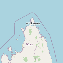
Map view of Analamerana Special Reserve

Use this park location map to pinpoint Analamerana Special Reserve in Madagascar, understand its exact geographic position, and read its mapped placement within the surrounding landscape more clearly.

Pigeon | © OpenStreetMap contributors

Location context for Analamerana Special Reserve

Diana
Park atlas

Compare regional conservation areas and neighboring northern Madagascar reserves

Explore Parks Near Réserve spéciale d'Analamerana and Surrounding Protected Landscapes

Browse protected areas near Réserve spéciale d'Analamerana to examine connected dry forest ecosystems across the Diana region. Comparing adjacent terrain helps evaluate limestone karst formations and rare wildlife habitats throughout northern Madagascar.
A watercolor landscape illustration depicting green bushes and grey, jagged rock formations under a soft pink and yellow sky.
Nature reserveDiana Region
9.3 km away#1 closest

Southwest

Ankarana Special Reserve: A Detailed Geographic Atlas of the Diana Region's Limestone Plateau

Mapping the karst landscape, subterranean rivers, and cliff formations.

Examine the rugged topography of Ankarana Special Reserve, featuring a 25-kilometre-long cliff known as the Wall of Ankarana and 100 kilometres of mapped cave passages. This protected area offers deep insight into Madagascar's geological history and rare endemic lemur habitats within its dense, jagged tsingy ridges.

Area
182 km²
Established
1956
IUCN
IV
Relief
Upland
National parkMadagascar
About 31 km away#2 closest

West

Montagne d'Ambre National Park: Mapped Volcanic Massif and Rainforest Boundaries in Madagascar

Protected montane landscape in the Diana Region of northern Madagascar

Centered around the prominent Mount Ambohitra, this national park showcases a distinct volcanic basaltic massif that creates a dramatic contrast with the nearby semi-desert terrain. Explore the geographic footprint of this biodiversity hotspot, featuring dense montane rainforests, numerous crater lakes, and cascading mountain waterfalls within the northern territory of Madagascar.

A watercolor painting showing a panoramic view of a calm lake surrounded by lush green hills and forests in Madagascar.
National parkDiana Region
About 31 km away#3 closest

West

Montagne d'Ambre National Park: Volcanic Landscapes and Rainforest Geography in Diana Region

Isolated montane ecosystems and volcanic mountain terrain

Montagne d'Ambre National Park forms a distinct volcanic massif in northern Madagascar, sheltering an isolated montane rainforest within the drier Diana Region. The protected area features a network of crater lakes and waterfalls, providing a crucial water catchment for the regional capital. Its unique terrain and dense humid forests act as a natural island for endemic species, creating a sharp contrast with the surrounding semi-arid landscape.

Area
182 km²
Established
1958
IUCN
II
Relief
Mountain
National parkDiana Region
About 69 km away#4 closest

Northwest

Nosy Hara National Park: Mapped Protected Landscape and Regional Geographic Context

Atlas exploration of national park boundaries and natural terrain.

Nosy Hara National Park is a designated national park situated within the Diana Region of Madagascar. This entry provides detailed geographic information, focusing on the park's mapped boundaries and its role as a protected landscape. Explore the unique regional geography and understand how this protected area contributes to the broader atlas of natural landscapes.

Area
2.7 km²
Relief
Lowland
Climate
Tropical
Access
Access unknown
National parkMadagascar
About 130 km away#5 closest

Southwest

Lokobe National Park: Madagascar's Protected Natural Landscape and Geographic Context

Explore mapped boundaries and regional park geography.

Lokobe National Park is a protected national park situated within Madagascar, an island country recognized globally for its exceptional biodiversity and unique ecosystems. This page offers a detailed, atlas-oriented perspective on Lokobe National Park, focusing on its designation as a protected area, its specific geographic location, and the natural landscape features that define its territory. Users can explore the park's mapped boundaries and understand its contribution to Madagascar's remarkable natural heritage.

Area
15.23 km²
Established
1927
IUCN
II
Climate
Tropical
Nature reserveDiana
About 132 km away#6 closest

Southwest

Réserve naturelle intégrale de Tsaratanana: Highland Massif and Protected Mountain Terrain

High-altitude geography in the Diana region of northern Madagascar

Spanning tens of thousands of hectares, the Réserve naturelle intégrale de Tsaratanana protects the highest mountain terrain in Madagascar. The landscape is defined by the crystalline Vohibory massif, creating a complex topography of deep valleys and dramatic elevation gradients that support endemic primate habitats and montane forest ecosystems.

Area
486.22 km²
Established
1927
IUCN
Ia
National parkMadagascar
About 142 km away#7 closest

Southwest

Nosy Tanikely National Park: Madagascar National Park & Protected Landscape Identity

Mapped geography and regional park context in Madagascar.

Nosy Tanikely National Park is a designated national park in Madagascar, offering a focused entry point for understanding protected land geography. As a key entity within the island's conservation landscape, it provides valuable context for exploring mapped park boundaries and regional geographic features. Discover how this protected area contributes to the broader atlas of Madagascar's natural heritage.

Area
3.41 km²
Established
2011
Relief
Lowland
Climate
Tropical
Wildlife reserveDiana
About 168 km away#8 closest

Southwest

Manongarivo Special Reserve: Protected Wildlife and River Landscapes in Northern Madagascar

Examining the humid forest terrain and geographic boundaries of the Diana region

Located in the Diana region, Manongarivo Special Reserve serves as a critical protected area within the northern humid rainforest system of Madagascar. The territory is defined by steep forested hills, narrow river valleys, and diverse ecological niches. By analyzing its specific topographic markers and river systems, this entry details the natural landscape and protected status of this significant biodiversity reserve.

Area
327.35 km²
Established
1956
IUCN
IV
Climate
Tropical

Common questions about visiting, size, designation, and location context for Analamerana Special Reserve

Analamerana Special Reserve FAQs for park facts, access, geography, and protected area context

Find quick answers about Analamerana Special Reserve, including protected-area facts, park geography, trail and visitor context, and how the park fits into its surrounding country and regional landscape.
MoriAtlas Explorer

Continue Your Protected Areas Search Across the Global Atlas

Deepen your exploration by continuing the structured search for national parks and protected areas worldwide. Utilize the comprehensive filtering capabilities to compare different conservation landscapes and refine your understanding of global park geography. Discover more about the distribution and characteristics of protected natural areas.

Global natural geography