
Mori Atlas logo
National parkRichtersveld National Park

Mapping the volcanic mountain ranges and fog-dependent ecosystems along the Orange River

Richtersveld National Park: A Deep Dive into Protected Arid Landscapes and Geography

Richtersveld National Park encompasses a dramatic desert region in the north-western corner of South Africa. This protected area features a unique mosaic of jagged volcanic mountains, sandy plains, and the riparian green corridor of the Orange River. As a critical component of the Succulent Karoo biome, the terrain provides a refuge for rare botanical life adapted to coastal fog. The landscape illustrates the intersection of traditional Nama transhumant herding and specialized conservation efforts in one of the world's most significant arid biodiversity hotspots.

arid desertSucculent Karoobiodiversity hotspotmountain desertOrange Rivertransfrontier park
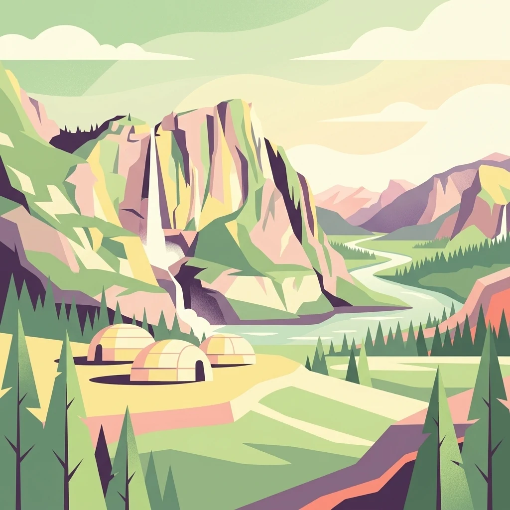
A stylized flat vector illustration of a valley with a winding river, a steep cliff featuring a waterfall, pine trees, and three small, rounded, hut-like dwellings in the foreground.

Richtersveld National Park

National park

Park overview

Structured park overview, official facts, and landscape profile for Richtersveld National Park

Richtersveld National Park park facts, protected area profile, and essential visitor context

Review the core facts for Richtersveld National Park, including designation, size, terrain, visitor scale, habitats, and operating context in one park-focused overview.

About Richtersveld National Park

Richtersveld National Park sits in one of the most geographically extreme corners of South Africa, tucked into the arid north-western edge of the Northern Cape where the country meets Namibia and the Atlantic Ocean. The park is essentially a desert landscape disguised as a mountain region, with sharp volcanic peaks, deeply cut gorges, expansive sandy plains, and the contrasting greenery of the Orange River valley all compressed into a relatively compact area. Elevations climb rapidly from sea level along the coast to over 1,300 metres in the interior ranges, producing dramatic scenery within short distances.

Ecologically, the park belongs to the Succulent Karoo biome, widely recognized as the world's only arid biodiversity hotspot. The flora is dominated by succulents and aloes adapted to extreme aridity, with a very high proportion of endemic species found nowhere else. Wildlife, while not as conspicuous as in wetter parks, includes a remarkable diversity of reptiles, small antelope, mountain zebra, baboons, leopards, and a rich avifauna that expands significantly during the winter rainfall season. The threatened Richtersveld katydid is endemic to the area, underscoring the park's importance for lesser-known species as well.

The cultural dimension is inseparable from the natural one. The park was established in 1991 after nearly two decades of negotiation between the National Parks Board and the Nama people, resulting in a protected area in which traditional transhumant herding continues to this day. This unusual arrangement combines formal conservation with maintaining a living indigenous land-use tradition, and it has shaped the park's management model ever since. As part of the broader Richtersveld landscape, the park is closely linked to the adjacent UNESCO World Heritage Site, which recognizes the area under cultural criteria for the enduring relationship between the Nama community and their environment.

Quick facts and research context for Richtersveld National Park

Richtersveld National Park lies in the Northern Cape of South Africa, bordering Namibia along the Orange River. It forms the South African component of the |Ai-|Ais/Richtersveld Transfrontier Park and sits adjacent to the Richtersveld Community Conservancy, which was inscribed as a UNESCO World Heritage Site in 2007 under cultural criteria.

The park covers roughly 1,624 square kilometres of arid mountain desert, with elevations ranging from sea level to over 1,300 metres at peaks such as Cornellberg. It falls within the Succulent Karoo and Nama Karoo transition zones, receiving as little as 5 millimetres of rainfall per year in the east and up to around 200 millimetres in the western mountains, supplemented by moisture-bearing fog from the Atlantic. The area is jointly managed by South African National Parks and the local Nama community, who retain traditional grazing rights inside the park.

Protection and recognition

Examine the designated protection scope, history, and administrative framework.

Richtersveld National Park Protection Status and Transboundary History

Richtersveld National Park maintains a documented terrestrial protection status established through designation records dating from 2007. Administrative parameters encompass a recognized transboundary framework detailing official management boundaries and designation history.

Protection details

Protection scope
Terrestrial
Designated year
2007
Transboundary protection
Yes
Park context

Deeper park guide and search-rich context for Richtersveld National Park

Richtersveld National Park history, landscape, wildlife, and travel context

Explore Richtersveld National Park through its history, landscape character, ecosystems, wildlife, conservation priorities, cultural context, and seasonal travel timing in a structured park guide built for atlas discovery and search intent.

Why Richtersveld National Park stands out

Richtersveld National Park is best known for its extraordinary concentration of succulent plant species and its status as a global arid biodiversity hotspot. Roughly 4,849 plant species have been documented in the broader Richtersveld, with around 40 percent endemic, including iconic forms like the quiver tree (kokerboom) and the enigmatic halfmensboom, or half-person tree, which leans toward the north and is revered by the Nama as a symbol of their ancestors. Equally defining is the park's cultural landscape: it is one of the last places where the traditional transhumant herding lifestyle of the Nama people, descendants of the broader Khoikhoi cultural group, continues in a meaningful way. The combination of desert mountain scenery, fog-dependent ecology, and living indigenous land use sets the Richtersveld apart from almost any other protected area in southern Africa.
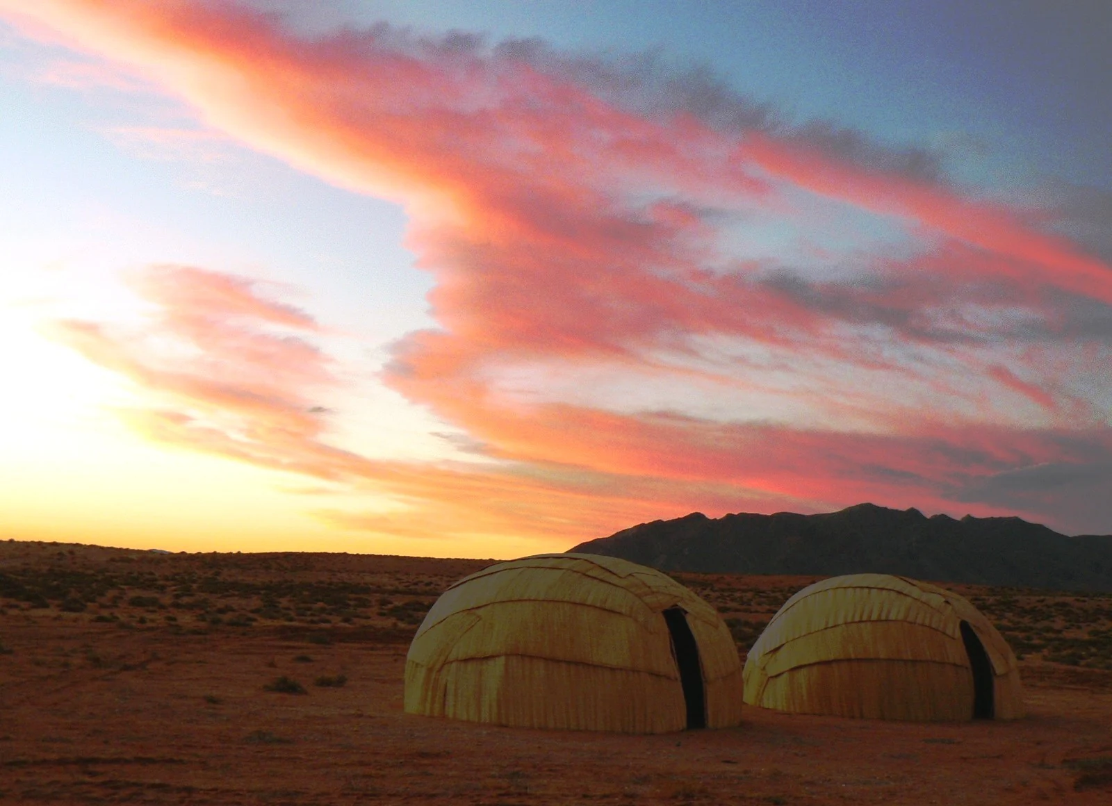
Two dome-shaped, woven traditional dwellings made of reeds sit on flat, arid ground under a vibrant pink and orange sunset sky.
Traditional mat houses, or matjieshuts, set against the arid landscape of the Richtersveld at sunset.

Richtersveld National Park history and protected-area timeline

The establishment of Richtersveld National Park was the result of an unusually long and deliberate negotiation between conservation authorities and local communities. After 18 years of talks between the National Parks Board and the Nama people, the northern part of the Richtersveld was officially proclaimed in 1991 as a protected area, with continued grazing and seasonal migration rights granted to the Nama herders who had lived there for generations.

This compromise was significant because it recognized that the area's conservation value was inseparable from the continued presence of the Nama and their traditional transhumant lifestyle. The park was formally designated to support future research and tourism while preserving the fragile succulent ecosystem on which both people and wildlife depend.

In 2003, South Africa and Namibia signed an agreement creating the |Ai-|Ais/Richtersveld Transfrontier Park, linking the South African Richtersveld National Park with the Ai-Ais nature area in Namibia, building on the existing Richtersveld community-managed lands. In June 2007, the Richtersveld Cultural and Botanical Landscape, just south of the National Park, was inscribed as a UNESCO World Heritage Site under cultural criteria, recognizing the enduring bond between the Nama people and their desert environment. Today the park remains jointly managed by South African National Parks and the local Nama community, a structure that continues to distinguish it within South Africa's national park system.

Richtersveld National Park landscape and geographic character

The Richtersveld National Park is defined by some of the most dramatic arid scenery in southern Africa. The terrain shifts abruptly between flat, sandy coastal plains, deeply incised kloofs and gorges, and high, jagged mountains composed of volcanic rock. These mountains, including the imposing Cornellberg, rise to over 1,300 metres and create sudden vertical relief that gives the park its reputation for rugged, constantly changing vistas.

Along the northern edge of the park, the Orange River provides a striking contrast to the surrounding desert. Its green corridor of riparian vegetation threads through otherwise barren country and marks the international boundary with Namibia. To the west, the park descends toward the Atlantic coast, where cool sea influences, fog, and strong winds shape both the climate and the ecology. To the east, conditions become even drier, transitioning into the Nama Karoo.

The combination of sharp mountain ridges, deep rocky valleys, open sandy plains, and the lush riverine fringe of the Orange River creates an unusually varied desert landscape within a relatively compact protected area. This physical diversity is a major reason why such an arid region supports so many distinct plant and animal communities.
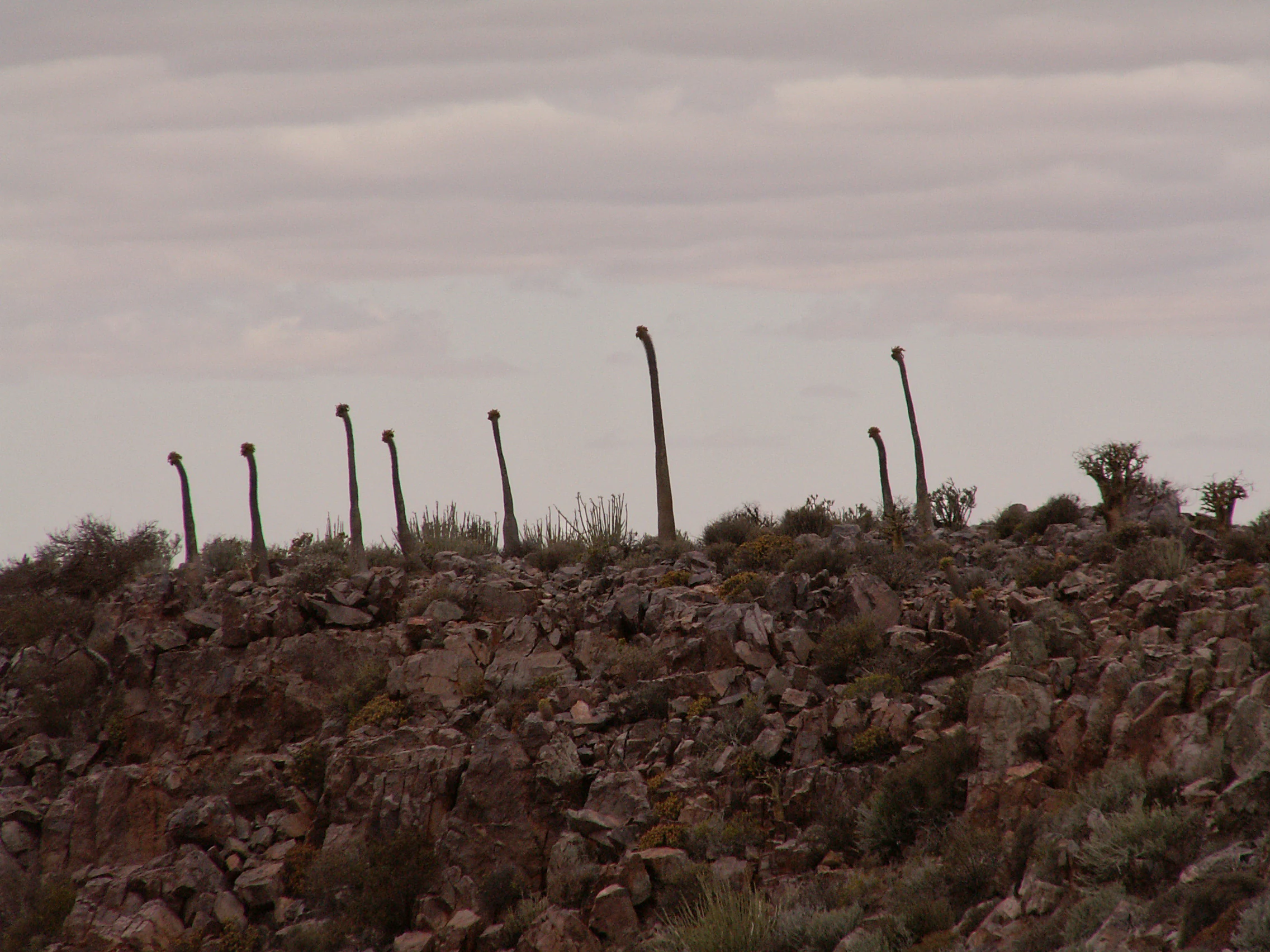
A group of tall, slender Pachypodium namaquanum succulent plants standing on a rocky, desert slope under an overcast sky.
A cluster of Halfmens plants (Pachypodium namaquanum) on a rocky hillside in Richtersveld National Park.

Richtersveld National Park ecosystems, habitats, and plant life

Richtersveld National Park sits within the Succulent Karoo, one of the world's most botanically rich arid regions and the only arid zone formally recognized as a biodiversity hotspot. Its vegetation is overwhelmingly dominated by succulents and aloes, many of which are highly specialized to survive on extremely low rainfall and seasonal fog. The broader Richtersveld region harbours around 4,849 documented plant species, with roughly 40 percent endemic, an unusually high share that reflects the isolation and harshness of the local environment.

The park lies in a transitional zone between the coastal Succulent Karoo to the west and the drier Nama Karoo to the east. Rainfall gradients within the park are extreme, ranging from as little as 5 millimetres per year in eastern areas to about 200 millimetres in the western mountains. The west receives primarily winter rainfall supplemented by moisture-bearing fog rolling in from the cold Atlantic, while the eastern regions rely more on occasional summer thunderstorms.

One of the most ecologically distinctive features of the Richtersveld is its endemism. Iconic plants such as the quiver tree (kokerboom) and the halfmensboom occur here, alongside several other tree aloes, dwarf succulents, and specialized bulbous plants. The botanical richness, combined with the fragility of the system, makes the Richtersveld an important reference area for understanding how life adapts to extremely arid conditions.

Richtersveld National Park wildlife and species highlights

Despite its arid character, Richtersveld National Park supports a surprisingly diverse range of mammal, reptile, and bird species, many of which are uniquely adapted to desert conditions. Mammals include grey rhebok, duiker, steenbok, klipspringer, Hartmann's mountain zebra, chacma baboon, vervet monkey, caracal, and African leopard, the latter being a particularly important predator in the rugged mountain terrain.

Reptile diversity is exceptional, reflecting the warm temperatures and rocky environments of the park. Snakes such as the puff adder, black spitting cobra, and the Nama tiger snake are present, along with numerous lizard species, particularly agamas. Spiders and scorpions add to the invertebrate fauna, occupying niches that few other animals can exploit in such an arid setting.

Birdlife shifts seasonally. Inland, weaver birds, doves, and guineafowl are common residents, but the winter rains bring a broader influx of species. The threatened Richtersveld katydid, an endemic insect, highlights the importance of the area for less conspicuous but ecologically significant species. For wildlife observers, the Richtersveld offers a more subtle kind of biodiversity shaped by adaptation to scarcity rather than seasonal abundance.

Richtersveld National Park conservation status and protection priorities

The Richtersveld is internationally recognized as the only arid biodiversity hotspot on Earth, a designation that highlights both its exceptional botanical richness and its vulnerability. Roughly 40 percent of the documented plant species in the broader Richtersveld region are endemic, meaning they grow nowhere else, which gives the area global conservation significance well beyond what its harsh climate might initially suggest.

The establishment of the park in 1991 was itself a conservation milestone, as it represented one of the first South African protected areas explicitly designed to accommodate continuing traditional land use. By allowing the Nama community to maintain transhumant grazing inside park boundaries, the model acknowledges that the succulent ecosystem evolved under, and continues to depend on, the influence of careful grazing patterns.

The adjacent Richtersveld Community Conservancy was inscribed as a UNESCO World Heritage Site in 2007, recognizing that the cultural survival of the Nama and the ecological integrity of the landscape are inseparable. Because the conservancy is not subject to diamond mining, unlike parts of the broader region, it preserves a more pristine ecological condition, reinforcing the conservation value of the integrated landscape. The park also forms the South African half of the |Ai-|Ais/Richtersveld Transfrontier Park, extending conservation cooperation across the international border with Namibia.

Richtersveld National Park cultural meaning and human context

The Richtersveld is one of the last places where the traditional lifestyle of the Nama people survives in any meaningful way. The Nama are part of the broader Khoikhoi cultural family, the largest surviving clan of a group that once occupied much of south-western Africa. Their identity remains deeply connected to the desert landscape, and they practice transhumance, moving seasonally with livestock across the fragile succulent ecosystem.

Many plants in the Richtersveld carry cultural meaning. The halfmensboom, or half-person tree, is revered by the Nama as the embodiment of their ancestors, half human and half plant, said to lean northward in mourning for their ancient Namibian homeland. Traditional mat houses, such as those still visible at sites like Glybank near Kuboes, reflect a continuing relationship with the land.

This living cultural landscape is the reason the Richtersveld Cultural and Botanical Landscape was inscribed as a UNESCO World Heritage Site under cultural criteria. The recognition reflects an understanding that conserving the environment here requires conserving the community that has shaped, and been shaped by, the desert for centuries.

Top sights and standout views in Richtersveld National Park

Richtersveld National Park is notable for its role as the South African component of the |Ai-|Ais/Richtersveld Transfrontier Park, linking protected desert ecosystems across the Namibia-South Africa border. Its high concentration of endemic succulents, including the iconic quiver trees and the culturally revered halfmensboom, places it among the most botanically significant arid regions in the world.

Mountain scenery is another defining strength: from the rugged kloofs and volcanic peaks around Cornellberg to the flat sandy coastal plains and the lush ribbon of the Orange River valley, the park compresses an extraordinary variety of desert landscapes into a relatively small area. Add to this the unique management partnership between South African National Parks and the Nama community, in which traditional transhumant grazing continues inside the protected area, and the Richtersveld stands out as a place where conservation, culture, and ecology genuinely overlap.

Best time to visit Richtersveld National Park

The Richtersveld experiences extreme seasonal variation that strongly affects both comfort and scenery. Summer temperatures in the region can approach 53 degrees Celsius in mid-summer, making daytime conditions harsh, while nights remain cool and bring heavy dew. Winter brings much colder nights, strong gale-force winds, occasional sandstorms, and gentle rainfall in the western mountains.

For visitors interested in the famous botanical display, late August through early October, spring in the Namaqualand region, is widely regarded as the most rewarding period, when daisies and vygies produce extensive blooms across the landscape. Birdwatching tends to be richer during the wetter winter months, when more species are active. Those primarily interested in cooler hiking conditions may prefer the milder transitional periods of April to May, when temperatures drop to more temperate levels before the winter winds intensify.

Monthly climate preview

Long-term temperature ranges and monthly precipitation rhythm for Richtersveld National Park

Richtersveld National Park Climate Normals and Annual Weather Patterns

Representative coordinates record sustained high maximum temperatures across summer alongside cooler winter lows and consistently low daily precipitation rates. Examining the full monthly climate profile reveals detailed temperature shifts and precipitation normals across the entire annual cycle.
Annual mean20 °C
14 °C26 °C
Jan25°
Feb26°
Mar25°
Apr22°
May18°
Jun14°
Jul14°
Aug14°
Sep18°
Oct21°
Nov22°
Dec24°
Warmest month
February

25.7 °C

Coolest month
July

13.6 °C

Wettest month
February

0.4 mm/day

Driest month
December

0.2 mm/day

Park location guide

Geography guide, regional context, and park location map for Richtersveld National Park

Richtersveld National Park park geography, regions, and map view in South Africa

Understand where Richtersveld National Park sits in South Africa through a broader geographic reading of the surrounding landscape, nearby location context, and its mapped position within the national park landscape.

How Richtersveld National Park fits into South Africa

South Africa is the southernmost country in Africa, spanning 1.22 million km² with a population of over 63 million. The country operates with three capital cities, Pretoria (executive), Cape Town (legislative), and Bloemfontein (judicial), and is renowned for its biodiversity, national parks, and multicultural society.

Wider geography shaping Richtersveld National Park in South Africa

South Africa occupies the southernmost region of Africa, with coastline along both the Atlantic Ocean to the west and the Indian Ocean to the east. The interior features elevated plateaus including the Highveld, with the Drakensberg escarpment marking the eastern highlands. The country shares borders with Namibia, Botswana, Zimbabwe, Mozambique, Eswatini, and Lesotho.

Map view of Richtersveld National Park

Use this park location map to pinpoint Richtersveld National Park in South Africa, understand its exact geographic position, and read its mapped placement within the surrounding landscape more clearly.

Pigeon | © OpenStreetMap contributors

Location context for Richtersveld National Park

Northern Cape
Natural feature types

Browse the Natural Features Atlas of Richtersveld National Park

Delve into the geography of Richtersveld National Park by examining the collection of mapped natural features. This data provides insights into the volcanic terrain, riverine systems, and mountain formations that define this arid biodiversity hotspot. Start exploring the specific landscape elements that shape the park environment.
Recorded earthquake history

Review the Historical Earthquake Catalogue for Richtersveld National Park

Examine historical seismic records documented in the area surrounding Richtersveld National Park. This catalogue provides a structured dataset of past earthquake events, their magnitudes, and epicentre distances to support regional geographic research and landscape context exploration.

Richtersveld National Park Earthquake History

Catalogued events

1 event

Strongest magnitude

Magnitude 3.9

Most recent event

Jun 3, 1993

This history includes earthquakes recorded inside the park or within 50 km of its borders

Visualizing rugged mountain terrain, arid desert habitats, and endemic flora

Richtersveld National Park Landscape and Scenery Photography

Visual documentation captures the dramatic volcanic kloofs, sandy coastal plains, and distinct succulent habitats defining Richtersveld National Park. Examining photographic records reveals the complex topography and fog dependent ecology shaping this arid South African protected area.

Two dome-shaped, woven traditional dwellings made of reeds sit on flat, arid ground under a vibrant pink and orange sunset sky.

A medium shot of a thick-stemmed, shrub-like succulent plant with orange-red flower stalks, surrounded by rocky desert terrain and sparse vegetation.

A group of tall, slender Pachypodium namaquanum succulent plants standing on a rocky, desert slope under an overcast sky.

Park atlas

Compare surrounding desert reserves and regional transfrontier conservation areas

Parks Near Richtersveld National Park And Related Protected Landscapes

Browse nearby national parks and protected areas connected to the rugged terrain of Richtersveld National Park. Comparing adjacent desert landscapes provides broader geographic context for the arid biodiversity hotspot.
Wildlife reserveNamibia
Mapped location lies within the park boundary#1 closest

North

ǀAi-ǀAis Hot Springs Game Park: A Namibian Wildlife Reserve Bridging Desert and Geothermal Landscapes

Explore mapped boundaries and regional park geography.

ǀAi-ǀAis Hot Springs Game Park represents a vital protected area within Namibia's arid southern reaches. This wildlife reserve is characterized by its namesake hot springs, which foster unique riparian ecosystems against a backdrop of rugged desert mountains and the impressive Fish River canyon. Its inclusion in a transfrontier conservation effort underscores its significance for regional landscape mapping and the preservation of stark desert beauty and geothermal features.

IUCN
II
Relief
Mixed relief
Climate
Arid
Access
Remote access
Protected areaNamibia
Mapped location lies within the park boundary#2 closest

North

Ai-Ais/Richtersveld Transfrontier Park: Mapped Boundaries of a Southern African Protected Area

Exploring its desert terrain and cross-border conservation geography.

Ai-Ais/Richtersveld Transfrontier Park is a significant protected area that spans across Namibia and South Africa, embodying a vital component of Southern Africa's conservation efforts. This page focuses on the park's geographic identity, detailing its arid landscape characteristics and the mapped extent of its protected boundaries. Understanding this transfrontier park offers insight into cross-border ecological cooperation and the unique desert terrain it encompasses, providing a foundation for structured geographic discovery.

Area
6,045 km²
Established
2003
IUCN
II
Relief
Mountain
National parkNorthern Cape
101 km away#3 closest

South

Namaqua National Park: Protected Landscape and Geographic Atlas Details

Explore Northern Cape's National Park mapped context.

Gain insight into Namaqua National Park, a protected national park situated in the expansive Northern Cape region of South Africa. This resource provides detailed geographic context, focusing on its mapped protected landscape and unique regional features. Understand its role as a distinct natural area for atlas-based exploration and geographic discovery within South Africa's diverse terrain.

Area
1,368.18 km²
Established
2001
Climate
Arid
Access
Moderate access
National parkNamibia
175 km away#4 closest

Northwest

Namib-Naukluft National Park: Namibia's Iconic Desert Landscape and Protected Terrain

Explore its ancient dunes, Naukluft mountains, and coastal geography.

Namib-Naukluft National Park is a colossal protected area in Namibia, holding the distinction of being Africa's largest national park. This park is renowned for its iconic sand dunes, particularly at Sossusvlei, which are among the highest in the world and display dramatic colors due to iron oxidation. The landscape also features the rugged Naukluft Mountains and vital coastal fog zones, creating a diverse arid environment. Delve into the mapped geography and unique terrain of this ancient desert setting, understanding its protected landscape significance within Namibia's atlas.

Area
49,768 km²
Established
1907
IUCN
II
Relief
Mixed relief
Nature reserveNamibia
About 218 km away#5 closest

North

Tirasberge Nature Reserve: Geography and Protected Landscapes of Southern Namibia

A compact wilderness spanning mountain massifs and desert frontiers.

The Tirasberge region serves as a vital protected area in southern Namibia, showcasing a diverse intersection of mountain ridges, red sand dunes, and arid savanna plains. This reserve provides a unique look into a stratified landscape where high elevation terrain meets the lower reaches of the Namib dune sea, creating a complex corridor for ecology and history. Understanding the reserve reveals how mountain-to-savanna transitions define the rugged character of this southern African conservation zone.

Area
1,250 km²
Established
1998
Relief
Mountain
Climate
Arid
National parkNamibia
About 237 km away#6 closest

Northwest

Tsau ǁKhaeb National Park: Namibia's Protected Area and Geographic Identity

Mapped natural landscape and park boundaries in Namibia.

Tsau ǁKhaeb National Park represents a vital protected area within Namibia, offering deep insights into the country's unique arid environments. This park detail page serves as an atlas entry focused on its mapped geography, highlighting its protected boundaries and its role within the broader landscape of Southern Africa. Explore the inherent geographic characteristics and conservation significance of this national park.

National parkNorthern Cape
238 km away#7 closest

East

Augrabies Falls National Park: A South African National Park Defined by Granite Gorge and Semi-Desert Terrain

Explore the mapped natural landscape and protected boundaries.

Augrabies Falls National Park in South Africa's Northern Cape Province is a key protected area known for its thundering waterfall on the Orange River and the profound granite gorge carved over millennia. The park's semi-desert environment showcases the distinctive quiver trees and geological landmarks like Moon Rock, offering a unique landscape context. Understand its protected status and geographic significance within the arid Nama-Karoo biome through detailed mapping and landscape information.

Area
820 km²
Established
1966
IUCN
II
Relief
Upland
A pale, minimalist watercolor painting showing layers of coastal hills, greenery, and dunes fading into a distant, hazy horizon.
Marine protected areaNamibia
About 256 km away#8 closest

Northwest

Meob-Chamais Islands’ Marine Protected Area: Mapped Coastal and Marine Sanctuary

A protected Atlantic marine region in coastal Namibia

Spanning from Meob Bay to Chamais Bay, this expansive marine protected area preserves the vital intersection between Namibia's arid desert shoreline and the cold, productive waters of the Atlantic. The region comprises ten primary islands and numerous islets that provide essential breeding platforms for bank cormorants and African penguins. This site remains a foundational element of regional coastal conservation and marine geography.

Area
20,000 km²
Established
2009
IUCN
VI
Scope
Marine

Common questions about visiting, size, designation, and location context for Richtersveld National Park

Richtersveld National Park FAQs for park facts, access, geography, and protected area context

Find quick answers about Richtersveld National Park, including protected-area facts, park geography, trail and visitor context, and how the park fits into its surrounding country and regional landscape.
MoriAtlas Explorer

Continue Your Protected Areas Search Across the Global Atlas

Deepen your exploration by continuing the structured search for national parks and protected areas worldwide. Utilize the comprehensive filtering capabilities to compare different conservation landscapes and refine your understanding of global park geography. Discover more about the distribution and characteristics of protected natural areas.

Global natural geography