

Mori Atlas logo
Nature reserveRoe Estuary Nature Reserve

Tracing the intertidal mudflats, salt marsh ecosystems, and estuarine river corridors

Roe Estuary Nature Reserve: A Detailed Geographic Atlas of Coastal Protected Landscapes

Roe Estuary Nature Reserve serves as a critical protected area situated at the mouth of the River Roe on the southeastern shores of Lough Foyle. This landscape encompasses an intricate mosaic of intertidal mudflats, expansive salt marsh, and submerged eel grass beds that define the coastal character of County Londonderry. Beyond its internal terrain, the reserve is framed by the dramatic Binevenagh escarpment and the broad Magilligan plain, establishing a unique transition zone between inland mountain geography and marine environments.

estuarywetlandsalt marshmudflatsbirdwatchingmigratory birds

Roe Estuary Nature Reserve

Nature reserve

Park overview

Structured park overview, official facts, and landscape profile for Roe Estuary Nature Reserve

Roe Estuary Nature Reserve park facts, protected area profile, and essential visitor context

Review the core facts for Roe Estuary Nature Reserve, including designation, size, terrain, visitor scale, habitats, and operating context in one park-focused overview.

About Roe Estuary Nature Reserve

Roe Estuary Nature Reserve occupies a strategic position along one of Northern Ireland's most important coastal wetland complexes. It sits at the point where the River Roe meets the much larger estuary of Lough Foyle, on the southeastern bank near the rural community of Aghanloo and a short distance north of Limavady. From this location the reserve connects the freshwater system of the Roe valley with the expansive tidal waters of Lough Foyle, making it both an ecological crossroads and a sheltered refuge for coastal wildlife.

The reserve's character is defined by the interplay of flowing river water, sheltered tidal channels, and the soft sedimentary features typical of large Atlantic estuaries. Vast stretches of salt marsh and intertidal mudflats are exposed and submerged by the rhythm of the tides, gradually building a productive habitat mosaic. Within this mosaic, beds of eel grass form underwater meadows that stabilize sediment and provide shelter for small marine animals such as mussels, periwinkles, lugworms, shrimps, and ragworms. These invertebrates form the foundation of the food web that sustains the reserve's rich bird populations.

The landscape surrounding the reserve reinforces its sense of place. To the east rises the Binevenagh plateau and its dramatic escarpment, which looks down over the estuary and the broader Magilligan plain. To the north, the windswept lowlands of Magilligan extend toward the open coast, while the wider Lough Foyle stretches northwest toward Derry. This juxtaposition of coastal flatlands, sheltered estuarine waters, and rugged inland cliff country makes the Roe Estuary a striking node within the regional geography of the north coast of Ireland.

Although compact and modest in scale, the reserve plays an outsized ecological role by concentrating bird activity and supporting transitional fish passages such as salmon moving between freshwater and marine environments. Otters have likewise been recorded along the estuary, adding a further layer of predator-prey interaction to the reserve's ecological character.

Quick facts and research context for Roe Estuary Nature Reserve

Roe Estuary Nature Reserve is a small protected area lying at the mouth of the River Roe on the southeastern bank of Lough Foyle in County Londonderry, Northern Ireland. It sits within the wider Atlantic coastal estuarine system that defines much of the north coast, immediately south of the Magilligan plain and west of the Binevenagh plateau.

The reserve is recognized for its combination of salt marsh, mudflats, and eel grass beds that provide feeding and roosting conditions for migratory and wintering birds. It also functions as a natural corridor for salmon moving between freshwater and marine environments, supporting the ecological continuity of the Roe catchment and Lough Foyle.

Protection and recognition

Examine the documented conservation scope and international recognition status

Roe Estuary Nature Reserve Protection Status and Governance

Roe Estuary Nature Reserve maintains a mixed protection scope with structured administrative records detailing its conservation framework. Review the verified designation history and recognized management parameters associated with this protected landscape.

Protection details

Protection scope
Mixed
Transboundary protection
No
Park context

Deeper park guide and search-rich context for Roe Estuary Nature Reserve

Roe Estuary Nature Reserve history, landscape, wildlife, and travel context

Explore Roe Estuary Nature Reserve through its history, landscape character, ecosystems, wildlife, conservation priorities, cultural context, and seasonal travel timing in a structured park guide built for atlas discovery and search intent.

Why Roe Estuary Nature Reserve stands out

Roe Estuary Nature Reserve is best known for the concentration of migratory and wintering birds that use its mudflats and salt marsh. Waders such as curlew, lapwing, turnstone, and bar-tailed godwit are regular visitors, while large numbers of ducks, swans, and brent geese also feed and rest in the area during the colder months. Equally distinctive is the way the reserve combines productive salt marsh habitat with beds of eel grass, creating conditions that support rich invertebrate communities including mussels, periwinkles, lugworms, shrimps, and ragworms. This combination of food-rich intertidal habitats and sheltered estuarine waters is what gives the reserve its strong reputation among birdwatchers and naturalists interested in coastal wildlife in Northern Ireland.
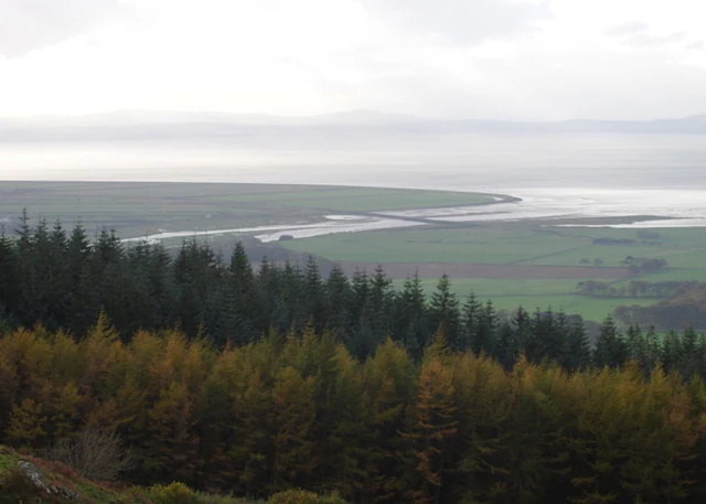
An elevated landscape view looking across a coniferous forest in the foreground toward a wide estuary and coastal plain under a misty sky.
A wide, elevated view overlooking the Roe Estuary mudflats and the surrounding plains.

Roe Estuary Nature Reserve landscape and geographic character

The landscape of Roe Estuary Nature Reserve is shaped almost entirely by water and sediment. At its core lie the broad intertidal mudflats of the River Roe estuary, regularly submerged and exposed by tidal movement. These are fringed by soft, low-lying salt marsh where halophytic vegetation has adapted to the saline conditions, and by shallow channels through which freshwater from the River Roe disperses into the saline waters of Lough Foyle.

Extensive beds of eel grass grow within the more sheltered portions of the estuary, forming distinctive underwater meadows that lend the reserve a layered seascape. The surrounding landforms amplify the visual character of the site: the sweeping Magilligan plain to the north provides a broad expanse of low coastal terrain, while the long escarpment of Binevenagh rises sharply to the east, framing the estuary from above and offering commanding views across the water toward Lough Foyle.

Roe Estuary Nature Reserve ecosystems, habitats, and plant life

Roe Estuary Nature Reserve is grounded in a classic estuarine ecosystem in which brackish water, mud, salt marsh, and submerged vegetation combine to produce high biological productivity. The salt marsh communities are dominated by salt-tolerant plants that stabilize sediments and shelter narrow tidal creeks, while the mudflats create rich foraging grounds for invertebrate life.

The eel grass beds are particularly important within this ecology, providing nursery and feeding habitat for a wide range of marine invertebrates that, in turn, sustain migratory and wintering birds. The salinity gradient from fully marine conditions in Lough Foyle to fresher water flowing from the River Roe gives the reserve an additional ecological dimension, allowing species adapted to differing salinities to coexist within a relatively small area.

Roe Estuary Nature Reserve wildlife and species highlights

The wildlife profile of Roe Estuary Nature Reserve is dominated by birds. It functions as a refuge for numerous species that migrate through the region or remain for the winter, with curlew, lapwing, turnstone, and bar-tailed godwit among the characteristic waders. Ducks, swans, and geese gather in substantial flocks, with brent goose being among the most notable seasonal visitors.

Beneath the surface, the estuary supports an active invertebrate community including mussels clinging to the substrate, periwinkles grazing on vegetation, and burrowing species such as lugworms, shrimps, and ragworms that rework the mudflats. Salmon move through the estuary as part of their wider life cycle, traveling between the freshwater stretches of the River Roe and the marine waters of Lough Foyle. Otters have also been recorded within the estuary, indicating that the habitat supports mammalian predators at the top of the local food chain.

Roe Estuary Nature Reserve conservation status and protection priorities

The reserve's conservation value lies in its function as a refuge within a wider network of wetland and estuarine habitats along the north coast of Ireland. By protecting a continuous stretch of salt marsh, mudflat, and eel grass habitat, the site helps safeguard feeding and roosting areas for migratory waders and wintering waterfowl, many of which are of recognized international importance across the broader Lough Foyle complex.

The protected area also contributes to the conservation of transitional aquatic species such as salmon by maintaining a functioning corridor between the River Roe and Lough Foyle. Maintaining the integrity of the mudflats and vegetation cover is central to this role, since the invertebrates that live within them underpin both the bird populations and the wider estuarine food web.

Top sights and standout views in Roe Estuary Nature Reserve

The defining highlights of Roe Estuary Nature Reserve are its intertidal flats, salt marsh, and eel grass beds, which together create one of the most productive wildlife habitats on this stretch of the Northern Ireland coast. The seasonal influx of curlew, lapwing, turnstone, bar-tailed godwit, brent goose, and other waterfowl gives the reserve a distinct and recognizable character at any time of year.

Equally notable is the wider geographical setting, with views across the estuary toward the Binevenagh escarpment and the Magilligan plain. The presence of salmon and otters along the same stretch of water reinforces the reserve's dual identity as both a bird-focused estuary and a functioning corridor for freshwater and marine fauna.

Best time to visit Roe Estuary Nature Reserve

The reserve is most rewarding during the cooler months of the year, when migratory and wintering waterfowl, including brent geese and large flocks of waders, are most numerous along the mudflats and salt marsh. Visiting at or near high tide often pushes birds closer to accessible points along the shoreline, improving viewing conditions for waders, ducks, and geese.

In spring and early summer, bird activity shifts toward breeding and passage species, while the surrounding landscape becomes more visually appealing as the Binevenagh escarpment and Magilligan plain take on warmer tones. Throughout the year, the interplay of tide, weather, and changing bird numbers gives the reserve a seasonal rhythm that rewards repeat visits.
Monthly climate preview

Long-term representative monthly averages for temperature and precipitation patterns

Roe Estuary Nature Reserve Climate Normals and Annual Temperature Rhythm

Representative coordinate records show measured monthly temperature ranges and daily precipitation values spanning the full annual cycle at Roe Estuary Nature Reserve. Detailed month-by-month climate profiles provide full visibility into historical weather patterns across the protected landscape.
Annual mean9 °C
5 °C14 °C
Jan
Feb
Mar
Apr
May10°
Jun13°
Jul14°
Aug14°
Sep12°
Oct10°
Nov
Dec
Warmest month
July

14.2 °C

Coolest month
January

4.7 °C

Wettest month
November

3.9 mm/day

Driest month
May

2.5 mm/day

Park location guide

Geography guide, regional context, and park location map for Roe Estuary Nature Reserve

Roe Estuary Nature Reserve park geography, regions, and map view in United Kingdom

Understand where Roe Estuary Nature Reserve sits in United Kingdom through a broader geographic reading of the surrounding landscape, nearby location context, and its mapped position within the national park landscape.

How Roe Estuary Nature Reserve fits into United Kingdom

The United Kingdom is a parliamentary constitutional monarchy located in northwestern Europe, consisting of four constituent countries: England, Scotland, Wales, and Northern Ireland. As a major global power with over 69 million residents, it maintains significant international influence in politics, economics, and culture.

Wider geography shaping Roe Estuary Nature Reserve in United Kingdom

The United Kingdom is an island nation located in northwestern Europe, surrounded by the Atlantic Ocean, North Sea, English Channel, Celtic Sea, and Irish Sea. It shares a land border with the Republic of Ireland to the west. The territory includes the island of Great Britain, the northeastern portion of Ireland, and most of the smaller British Isles islands.

Map view of Roe Estuary Nature Reserve

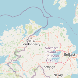
Use this park location map to pinpoint Roe Estuary Nature Reserve in United Kingdom, understand its exact geographic position, and read its mapped placement within the surrounding landscape more clearly.

Pigeon | © OpenStreetMap contributors

Location context for Roe Estuary Nature Reserve

County Londonderry

Visualizing intertidal mudflats, salt marshes, and estuarine habitats across Northern Ireland

Roe Estuary Nature Reserve Photos and Landscape Scenery

Visual documentation captures the shifting mudflats, salt marshes, and eel grass beds that define Roe Estuary Nature Reserve. Photographic records reveal the wider protected landscape, illustrating how estuarine waters interface with neighboring coastal plains and mountain scarps.

An elevated landscape view looking across a coniferous forest in the foreground toward a wide estuary and coastal plain under a misty sky.

Park atlas

Compare regional coastal habitats, estuaries, and nearby protected natural areas

Other Parks Near Roe Estuary Nature Reserve and Surrounding Protected Landscapes

Visitors exploring Roe Estuary Nature Reserve can continue browsing adjacent coastal reserves, tidal wetlands, and regional protected landscapes across Northern Ireland. Expanding the search reveals connected wildlife corridors and similar estuarine habitats that share the same coastal geography.
Protected areaCounty Antrim
About 36 km away#1 closest

Northeast

Benbane Head Protected Area: Geographic Profile and Regional Landscape Mapping

Coastal terrain and protected boundaries in County Antrim

Examine the geographic characteristics of Benbane Head, a significant protected area located in County Antrim. This profile highlights the site's physical boundaries and its place within the regional landscape, providing essential mapping context for understanding Northern Ireland's diverse natural terrain and conservation geography.

Area
0.052 km²
Established
1953
Relief
Lowland
Climate
Temperate
Nature reserveNorthern Ireland
About 36 km away#2 closest

Southeast

Ballynahone Bog: Northern Ireland Lowland Raised Peatland and Wetland Geography

Intact active bog dome and protected wetland landscape

Examine the geography of Ballynahone Bog, one of the largest remaining lowland raised bogs in Northern Ireland. This protected landscape preserves an active peat-forming surface, intricate hummock and pool complexes, and marginal fen habitats, offering insight into the ecological history and hydrological patterns of the Lough Neagh lowland region.

Area
2.432 km²
Established
1995
Relief
Lowland
Climate
Temperate
Nature reserveNorthern Ireland
About 48 km away#3 closest

Southeast

Lough Beg Nature Reserve: Mapping the Wetlands and Floodplains of Northern Ireland

An essential protected landscape within the Lough Neagh basin.

Lough Beg provides a distinct geographic study of freshwater ecosystems and alluvial landscapes. As a designated nature reserve, it forms a crucial link in the Lower Bann catchment, characterized by its shallow waters and seasonal pasture flooding. The area serves as a primary hub for migratory bird species, while the historic Church Island offers a unique convergence of early Christian heritage and natural wetland terrain.

Relief
Lowland
Climate
Temperate
Access
Easy access
Scope
Terrestrial
Protected areaCounty Antrim
About 50 km away#4 closest

East

Slieveanorra Forest Protected Area: Geography, Maps, and Upland Landscape Context

A comprehensive look at the Antrim forest and glacial landscape.

Slieveanorra Forest serves as a prominent protected area within the County Antrim uplands. Featuring expansive conifer woodlands, the site includes rugged terrain, reservoir edges, and scenic summit views. Understand the geological and environmental composition of this working forest landscape through its mapped boundaries and regional context.

Relief
Upland
Water
Minor water
Watercolor illustration of a mountainous landscape with a lake and forests
National parkCounty Donegal
About 58 km away#5 closest

West

Glenveagh National Park: A Protected Landscape in the Heart of County Donegal

Mapped geography and natural terrain for Ireland's national park.

Delve into the geographic specifics of Glenveagh National Park, a protected area situated in County Donegal. This section provides detailed information on its mapped boundaries and regional landscape context. Understand how this national park fits within the natural geography of Ulster, offering a structured atlas view for detailed exploration of its unique terrain and protected status.

Area
169.58 km²
Established
1986
IUCN
II
Relief
Mixed relief
Nature reserveNorthern Ireland
About 79 km away#6 closest

Southeast

Oxford Island National Nature Reserve: Protected Wetland Landscapes of Northern Ireland

Lakeshore habitats and woodland geography at Lough Neagh

Oxford Island is a prominent nature reserve where terrestrial woodland meets the expansive waters of Lough Neagh. The site showcases a transition of reed beds and meadows that serve as vital ecological assets within the regional geography of Northern Ireland, offering a dense, accessible look at lowland wetland environments.

Area
1.14 km²
Relief
Lowland
Climate
Temperate
Access
Easy access
Protected landscapeCounty Fermanagh
About 85 km away#7 closest

Southwest

Castle Archdale Protected Landscape in County Fermanagh: Geography and Map Overview

Lakeside woodland and historic terrain on Lower Lough Erne

Located on the shores of Lower Lough Erne, Castle Archdale represents a unique protected landscape in County Fermanagh. The area features a complex mosaic of sheltered inlets, mature woodland, and open parkland that characterises the Fermanagh lakelands. Beyond its physical terrain, the site is defined by its historical significance, from seventeenth century estate remnants to its role as a pivotal wartime flying boat base, providing a rich context for geographic and environmental exploration.

Relief
Lowland
Climate
Temperate
Access
Easy access
Scope
Terrestrial
Nature reserveCounty Fermanagh
About 109 km away#8 closest

South

Crom Estate Nature Reserve and Upper Lough Erne Geographic Landscape Overview

Riparian forest and island geography in County Fermanagh

Deeply connected to the shores of Upper Lough Erne, Crom Estate is a sprawling nature reserve defined by its ancient riparian woodlands and intricate maze of bays and islands. The terrain preserves a distinct mix of old-growth forest, open grassland, and historic castle ruins, providing a valuable case study in the regional geography of County Fermanagh and the conservation of water-influenced ecosystems.

Area
5.5 km²
Established
1987
Relief
Lowland
Climate
Temperate

Common questions about visiting, size, designation, and location context for Roe Estuary Nature Reserve

Roe Estuary Nature Reserve FAQs for park facts, access, geography, and protected area context

Find quick answers about Roe Estuary Nature Reserve, including protected-area facts, park geography, trail and visitor context, and how the park fits into its surrounding country and regional landscape.
MoriAtlas Explorer

Continue Your Protected Areas Search Across the Global Atlas

Deepen your exploration by continuing the structured search for national parks and protected areas worldwide. Utilize the comprehensive filtering capabilities to compare different conservation landscapes and refine your understanding of global park geography. Discover more about the distribution and characteristics of protected natural areas.

Global natural geography
