

Mori Atlas logo
Protected areaSaluga and Ghazal Protectorate

Discover the mapped boundaries and landscape characteristics of this protected area.

Saluga and Ghazal Protectorate: Protected Area Identity and Geographic Context in Egypt

(Salouga and Ghazal Protected Area)

The Saluga and Ghazal Protectorate represents a significant protected area within Egypt, offering valuable insights into the country's natural landscapes. This page provides detailed geographic information and mapped boundaries, allowing for a comprehensive understanding of the protectorate's role in regional conservation and its physical terrain. Explore its context within the broader geography of Egypt through atlas-driven discovery tools.

Nile IslandsRiver Protected AreasEgyptian Protected AreasNilotic VegetationRiparian EcosystemsBird Habitats

Saluga and Ghazal Protectorate

Protected area

Park overview

Structured park overview, official facts, and landscape profile for Saluga and Ghazal Protectorate

Saluga and Ghazal Protectorate park facts, protected area profile, and essential visitor context

Review the core facts for Saluga and Ghazal Protectorate, including designation, size, terrain, visitor scale, habitats, and operating context in one park-focused overview.

About Saluga and Ghazal Protectorate

The Saluga and Ghazal Protectorate represents a unique conservation challenge and opportunity in southern Egypt. These two islands, situated within the Nile River channel south of Aswan, contain ecological communities that have largely vanished from the surrounding mainland floodplain. The protectorate was established in 1986 specifically to protect the biological diversity of threatened animals, plants, and mammals in this riverine environment. What makes these islands particularly significant is their role as living remnants of the natural vegetation that historically covered the Nile Valley before thousands of years of agricultural development transformed the region. The islands support luxuriant natural vegetation that represents some of the last intact examples of unmodified nilotic ecosystems in the entire valley. Beyond their ecological importance, these islands form part of the scenic character that has long drawn visitors to the Aswan area, creating a natural contrast to the surrounding desert and cultivated landscapes.

Quick facts and research context for Saluga and Ghazal Protectorate

The Saluga and Ghazal Protectorate covers two river islands in the Nile south of Aswan, making it one of Egypt's smallest protected areas. Established in 1986, it preserves approximately 94 species of vegetation, including rare remnants of natural nilotic flora that existed before widespread cultivation in the Nile Valley. The islands support diverse birdlife and characteristic Nile fauna within a landscape that has become one of Aswan's primary tourist attractions. Management falls under the Egyptian Environmental Affairs Authority.

Protection and recognition

Tracing the official terrestrial designation, creation history, and regional conservation footprint.

Documented Protection Status and Legal Designation of Saluga and Ghazal Protectorate

Map-based explorer records trace the official establishment of the Saluga and Ghazal Protectorate back to its terrestrial designation in 1986. Understanding the formal boundary status and legal frameworks helps researchers analyze local Nile conservation frameworks and broader regional environmental management datasets.

Protection details

Protection scope
Terrestrial
Designated year
1986
Park context

Deeper park guide and search-rich context for Saluga and Ghazal Protectorate

Saluga and Ghazal Protectorate history, landscape, wildlife, and travel context

Explore Saluga and Ghazal Protectorate through its history, landscape character, ecosystems, wildlife, conservation priorities, cultural context, and seasonal travel timing in a structured park guide built for atlas discovery and search intent.

Why Saluga and Ghazal Protectorate stands out

Saluga and Ghazal Protectorate is best known for preserving some of the only remaining fragments of natural nilotic vegetation in the Nile Valley, a landscape that has been largely transformed by agriculture and development. The islands support exceptional botanical diversity with around 94 plant species, including vegetation types that once characterized the entire Nile floodplain before human modification. The protected area also serves as a critical habitat for waterbirds and other characteristic Nile fauna, making it an important ecological island within a heavily altered landscape.

Saluga and Ghazal Protectorate history and protected-area timeline

The Saluga and Ghazal Protectorate was formally established in 1986 as part of Egypt's expanding network of protected areas managed by the Egyptian Environmental Affairs Authority. The designation responded to growing recognition that the natural nilotic vegetation communities of the Nile Valley had been nearly eliminated by centuries of agricultural development and river modification. These two islands, situated downstream of the Aswan Dam, had retained vegetation communities that had disappeared from mainland areas, making them increasingly valuable as conservation relics. The establishment reflected a broader Egyptian commitment to preserving representative samples of the country's diverse ecosystems, from desert environments to riverine habitats. The protectorate's management has focused on maintaining the biological integrity of the islands while addressing threats from human activities, particularly the fire hazards posed by careless use of fire on adjacent mainland areas.

Saluga and Ghazal Protectorate landscape and geographic character

The Saluga and Ghazal Protectorate occupies two islands within the Nile River channel, creating a riverine landscape distinct from the desert and agricultural environments that dominate the surrounding region. The islands rise slightly above the river's surface, supporting lush vegetation that contrasts sharply with the arid terrain on either bank. The Nile flows past these islands in a relatively slow, meandering pattern at this point in its course, creating conditions that support extensive wetlands and riparian vegetation communities. The landscape represents a narrow band of green along the river, visible from the Aswan waterfront as a natural oasis amid the otherwise brown and golden hues of the eastern Sahara. The visual impact of these vegetated islands against the desert backdrop has made them a recognizable element of the Aswan scenic landscape.

Saluga and Ghazal Protectorate ecosystems, habitats, and plant life

The ecological significance of the Saluga and Ghazal Protectorate stems primarily from its preservation of natural nilotic vegetation communities that have been largely eliminated from the Nile Valley. The islands support approximately 94 plant species, representing botanical diversity that exists almost nowhere else in the region. These vegetation communities include characteristic nilotic species adapted to the seasonal flooding patterns and river environment that historically defined the Nile floodplain. The islands function as ecological refugia, maintaining plant communities that evolved under natural river conditions before the construction of dams and the expansion of irrigation agriculture transformed the valley. The riparian habitat also creates conditions favorable to diverse invertebrate communities and supports the base of food webs that sustain the area's bird and animal populations.

Saluga and Ghazal Protectorate wildlife and species highlights

The Saluga and Ghazal Protectorate shelters diverse birdlife characteristic of Nile River habitats, with the islands serving as important nesting, feeding, and resting areas for species that depend on riverine environments. The vegetation provides shelter and foraging opportunities for numerous bird species, while the water surrounding the islands offers feeding grounds for waterbirds. The protected area maintains populations of characteristic Nile fauna that have largely disappeared from mainland areas as the surrounding landscape has been modified for agriculture and development. The islands' isolation within the river channel provides some protection from the pressures that have affected wildlife populations in adjacent terrestrial environments, allowing these river-dependent species to persist in a region where suitable habitat has become increasingly scarce.

Saluga and Ghazal Protectorate conservation status and protection priorities

The Saluga and Ghazal Protectorate plays an outsized role in Egypt's conservation network relative to its small size, preserving vegetation types and ecological communities that exist virtually nowhere else in the Nile Valley. The islands represent irreplaceable repositories of genetic material and ecological processes that have been eliminated from the vast majority of the valley's former natural areas. Conservation of these islands is complicated by their position within a heavily modified river system and their exposure to pressures from the surrounding mainland, including fire risk from human activities. The protected area demonstrates both the vulnerability of isolated riverine habitats and their critical importance as refugia for biodiversity in heavily altered landscapes. Maintaining the ecological integrity of these islands requires ongoing management attention to both internal conservation needs and external threats originating from adjacent human-modified landscapes.

Saluga and Ghazal Protectorate cultural meaning and human context

The name "Salouga" derives from the ancient Nubian language, in which it means waterfall, connecting these islands to the linguistic heritage of the Nubian peoples who historically inhabited this region of the Nile Valley. This linguistic connection underscores the long human relationship with the river and its seasonal patterns, as the term reflects the dynamic hydrological character of this part of the Nile where water movement created the conditions for the rapids or small waterfalls that gave the islands their name. The protectorate lies in a region of exceptional cultural significance, where ancient Egyptian and Nubian civilizations developed along the Nile's banks and where contemporary Egyptian and Nubian communities maintain connections to traditional land-use practices. The islands themselves, while now protected from direct human settlement and cultivation, exist within a cultural landscape shaped by centuries of agricultural and pastoral activities along the Nile.

Top sights and standout views in Saluga and Ghazal Protectorate

The Saluga and Ghazal Protectorate preserves some of the only remaining natural nilotic vegetation in the Nile Valley, representing an ecological relic of the pre-agricultural landscape that once dominated this region. The islands support approximately 94 plant species in a concentrated riparian habitat, creating remarkable botanical diversity within a small area. The protected area provides critical habitat for Nile-dependent bird species and other wildlife in a region where natural habitats have been largely eliminated. The scenic value of these vegetated islands against the desert backdrop has made them a long-standing element of the Aswan tourism landscape, offering visitors a glimpse of the natural Nile that existed before extensive human modification.

Best time to visit Saluga and Ghazal Protectorate

The Saluga and Ghazal Protectorate can be visited year-round, though the experience varies with Egypt's seasonal climate. The winter months from November through February offer the most comfortable temperatures for viewing the islands and their wildlife, with mild days ideal for boat tours and birdwatching activities. Summer months bring higher temperatures that may reduce the comfort of extended outdoor activities on the water. The Nile's water levels fluctuate seasonally, affecting the visual relationship between the islands and the river channel. The best wildlife viewing opportunities occur during migration seasons when additional bird species pass through the area, though the resident avifauna is present throughout the year.
Monthly climate preview

Monthly temperature ranges and long-term precipitation averages across the coordinate

Saluga and Ghazal Protectorate Climate Normals and Temperature Patterns

Saluga and Ghazal Protectorate records long-term monthly temperatures ranging from moderate winter minimums to high summer maximums alongside minimal daily precipitation values. Examining the complete twelve-month climate profile reveals precise seasonal shifts and detailed temperature variations across the protected area.
Annual mean26 °C
15 °C34 °C
Jan15°
Feb17°
Mar21°
Apr27°
May31°
Jun33°
Jul34°
Aug34°
Sep32°
Oct28°
Nov22°
Dec17°
Warmest month
August

33.9 °C

Coolest month
January

15 °C

Wettest month
January

0 mm/day

Driest month
February

0 mm/day

Park location guide

Geography guide, regional context, and park location map for Saluga and Ghazal Protectorate

Saluga and Ghazal Protectorate park geography, regions, and map view in Egypt

Understand where Saluga and Ghazal Protectorate sits in Egypt through a broader geographic reading of the surrounding landscape, nearby location context, and its mapped position within the national park landscape.

How Saluga and Ghazal Protectorate fits into Egypt

Egypt is a transcontinental country bridging Northeast Africa and Southwest Asia via the Sinai Peninsula. With over 107 million inhabitants, it is the most populous country in the Arab world and third-most populous in Africa. The country features a rich historical heritage dating back to ancient civilizations along the Nile Delta, with Cairo as its capital and largest city.

Wider geography shaping Saluga and Ghazal Protectorate in Egypt

Egypt occupies a strategic position in Northeast Africa, extending into Southwest Asia through the Sinai Peninsula. It is bordered by the Mediterranean Sea to the north, Palestine and Israel to the northeast, the Red Sea to the east, Sudan to the south, and Libya to the west. The Gulf of Aqaba in the northeast separates Egypt from Jordan and Saudi Arabia. The country features the Nile Delta and Valley as its main fertile region, surrounded by desert terrain.

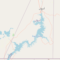
Map view of Saluga and Ghazal Protectorate

Use this park location map to pinpoint Saluga and Ghazal Protectorate in Egypt, understand its exact geographic position, and read its mapped placement within the surrounding landscape more clearly.

Pigeon | © OpenStreetMap contributors

Location context for Saluga and Ghazal Protectorate

Aswan Governorate
Park atlas

Trace the broader geographic spread of protected landscapes across Egypt, comparing riverine habitats and desert conservation areas.

Explore Nearby National Parks and Protected Areas Beyond Saluga and Ghazal Protectorate

Discover other national parks and protected areas near Saluga and Ghazal Protectorate, mapping their locations and exploring varied natural habitats across the Nile Valley and surrounding Egyptian regions. Compare the unique riverine ecosystem of Saluga and Ghazal with adjacent conservation landscapes, understanding the broader regional distribution of protected areas and Egypt's diverse ecological zones.
National parkEgypt
About 167 km away#1 closest

Southeast

Gabal Elba National Park: Protected Landscape Geography in Egypt

Mapped terrain and regional context for this Egyptian national park.

Delve into the geographic identity of Gabal Elba National Park, a protected national park within Egypt. This resource supports atlas exploration by detailing its protected landscape, mapped boundaries, and how it fits into the broader regional geography. Understand the natural terrain and conservation significance of this distinct Egyptian protected area through detailed geographic information.

Area
35,600 km²
Established
1986
IUCN
II
Relief
Mountain
National parkEgypt
About 223 km away#2 closest

East

Wadi El Gamal National Park: Protected Landscape and Geographic Atlas of Egypt

Explore the mapped terrain and protected boundaries.

Wadi El Gamal National Park is a key protected national park within Egypt, offering a unique lens through which to explore its geographic setting and mapped natural landscapes. This destination provides structured insight into the park's identity as a protected area, its place within the regional geography of Egypt, and the visual context of its terrain. Understand the mapped park boundaries and landscape features that contribute to its atlas value.

Access
Access unknown
National parkEgypt
About 223 km away#3 closest

East

Wadi El Gemal National Park National Park: Egypt's Protected Landscape and Geography

Explore the mapped boundaries and regional context of this Egyptian national park.

Wadi El Gemal National Park offers a detailed look into a significant protected natural area within Egypt. As a national park, it presents a specific landscape identity with clearly defined geographic boundaries that are invaluable for atlas-based exploration. Users can delve into the mapped terrain and understand the regional geographic context surrounding this protected land, enhancing their comprehension of Egypt's natural heritage.

Area
6,870 km²
Established
2003
Relief
Mountain
Scope
Mixed
National parkSouth Sinai Governorate
About 431 km away#4 closest

North

Ras Muhammad National Park: South Sinai Protected Landscape and Geographic Atlas

Discover the mapped boundaries of this Egyptian national park.

Ras Muhammad National Park is a crucial protected area within the South Sinai Governorate, offering insights into Egypt's natural landscapes. This page facilitates an atlas-style exploration of the park, highlighting its geographic significance and protected status. Users can investigate its mapped terrain and understand its context within the regional geography of the Sinai Peninsula for structured geographic discovery.

Area
480 km²
Established
1983
Relief
Mixed relief
Climate
Arid
Protected areaSouth Sinai Governorate
About 490 km away#5 closest

North

Nabq Protected Area: South Sinai Governorate Protected Landscape and Regional Geography

Explore its mapped terrain and protected area context.

Nabq Protected Area offers a distinct view into Egypt's protected landscapes, situated within the South Sinai Governorate. This detailed page provides an atlas-style perspective on its geographic setting, allowing for structured exploration of its mapped boundaries and its role within the regional context. Understand the unique natural terrain and protected area characteristics that define this significant Egyptian site.

Area
600 km²
Established
1992
IUCN
VI
Relief
Mountain
National parkEgypt
About 508 km away#6 closest

North

Saint Katherine Protectorate National Park: Egypt's Protected Landscape and Geographic Identity

Mapped boundaries and regional terrain discovery for this Egyptian protected area.

Saint Katherine Protectorate is a key national park in Egypt, representing a significant protected landscape within the Sinai Peninsula. This page offers a detailed atlas view of its protected boundaries and geographic context. Users can explore its position within Egypt's broader geography and understand its role as a vital protected area for regional landscape study.

Established
1983
Relief
Mountain
Climate
Alpine
Access
Moderate access
National parkNew Valley Governorate
About 588 km away#7 closest

Northwest

White Desert National Park: Egypt's Surreal Chalk Rock Protected Landscape Atlas

Explore mapped terrain and unique desert formations.

White Desert National Park, situated in the New Valley Governorate of Egypt, offers a visually stunning protected landscape defined by its iconic white chalk formations. These geological wonders, sculpted by wind and sand into fantastical shapes, create an almost lunar environment. As a national park, it serves as a vital protected area, showcasing the dramatic geography where chalk spires meet Sahara dunes and supporting unique desert ecosystems within its mapped boundaries.

Area
300 km²
Established
2002
IUCN
II
Relief
Lowland
National parkNew Valley Governorate
About 718 km away#8 closest

West

Gilf Kebir National Park: Sahara Wilderness with Prehistoric Rock Art and Silica Glass

Explore the geography of this vast Egyptian national park and its ancient landscapes.

Gilf Kebir National Park offers a profound exploration of a remote Saharan environment within Egypt's New Valley Governorate. This protected national park is distinguished by its hyper-arid desert landscape, encompassing portions of the Great Sand Sea and the dramatic Gilf Kebir plateau dissected by ancient wadis. It is globally recognized for its rich concentration of prehistoric rock art, providing a direct connection to early human history in the Sahara, alongside the scientifically unique Silica Glass area.

Area
48,533 km²
Established
2007
IUCN
II
Relief
Mixed relief

Common questions about visiting, size, designation, and location context for Saluga and Ghazal Protectorate

Saluga and Ghazal Protectorate FAQs for park facts, access, geography, and protected area context

Find quick answers about Saluga and Ghazal Protectorate, including protected-area facts, park geography, trail and visitor context, and how the park fits into its surrounding country and regional landscape.
MoriAtlas Explorer

Continue Your Protected Areas Search Across the Global Atlas

Deepen your exploration by continuing the structured search for national parks and protected areas worldwide. Utilize the comprehensive filtering capabilities to compare different conservation landscapes and refine your understanding of global park geography. Discover more about the distribution and characteristics of protected natural areas.

Global natural geography