Mori Atlas logo
National parkRas Muhammad National Park

Map the boundaries and explore the geographic context of this national park in Egypt.

Ras Muhammad National Park: Protected Landscape and Regional Geography in South Sinai

Ras Muhammad National Park represents a significant protected area within the South Sinai Governorate, offering a distinct geographic landscape for atlas exploration. This national park serves as a key entity for understanding Egypt's protected lands and their regional distribution. Through MoriAtlas, users can engage with the park's mapped boundaries and its place within the broader natural geography of the Sinai Peninsula, providing structured insights for geographic discovery.

Marine Protected AreaCoral ReefsRed SeaSinai PeninsulaDesert LandscapeDiving Destination

Ras Muhammad National Park

National park

Park overview

Structured park overview, official facts, and landscape profile for Ras Muhammad National Park

Ras Muhammad National Park park facts, protected area profile, and essential visitor context
Review the core facts for Ras Muhammad National Park, including designation, size, terrain, visitor scale, habitats, and operating context in one park-focused overview.

About Ras Muhammad National Park

Ras Muhammad National Park represents one of Egypt's most significant conservation achievements, established in 1983 by the Egyptian Environmental Affairs Agency to protect both marine and terrestrial ecosystems from the pressures of coastal development and overfishing. The park's creation responded to growing concerns about destructive fishing practices, including dynamite fishing and other methods that were damaging coral reefs and depleting fish populations. Situated at the tip of the Sinai Peninsula, the park occupies a unique geographic position where the Red Sea's two major gulfs converge, creating distinctive marine conditions that support extraordinary biodiversity. The park also serves as a buffer against urban sprawl from the rapidly expanding resort city of Sharm El Sheikh, preserving a critical natural landscape at the edge of one of Egypt's most important tourism destinations. Beyond its ecological significance, the area holds historical importance as the ancient site known as Poseidion, reflecting human connection to this coastal landscape stretching back to classical antiquity.

Quick facts and research context for Ras Muhammad National Park

Ras Muhammad National Park lies 12 kilometers from Sharm El Sheikh in South Sinai Governorate, occupying the peninsula's southern extreme between the Gulf of Suez and Gulf of Aqaba. The park covers 480 square kilometers including 135 square kilometers of land and 345 square kilometers of marine area. Summer temperatures regularly exceed 40°C while winter highs average around 23°C, with rainfall minimal throughout the year. The park protects over 220 coral species and more than 1,000 fish species, alongside important terrestrial habitats including desert wadis and a mangrove forest system.

Park context

Deeper park guide and search-rich context for Ras Muhammad National Park

Ras Muhammad National Park history, landscape, wildlife, and travel context
Explore Ras Muhammad National Park through its history, landscape character, ecosystems, wildlife, conservation priorities, cultural context, and seasonal travel timing in a structured park guide built for atlas discovery and search intent.

Why Ras Muhammad National Park stands out

Ras Muhammad is internationally renowned for its exceptional coral reef ecosystems, which feature both fringing and hermatypic coral formations extending along the coastline. The park's underwater landscape includes world-famous dive sites such as Shark Reef, Yolanda Reef, and the wreckage of the SS Thistlegorm, a World War II merchant vessel that has become an iconic dive destination. The park harbors more than 1,000 fish species alongside populations of green sea turtles and hawksbill turtles. Its mangrove forest at the peninsula's southern end represents a rare coastal wetland ecosystem in this arid region, while the surrounding desert landscape of mountains, wadis, and coastal plains supports a distinct terrestrial ecology.

Ras Muhammad National Park history and protected-area timeline

The promontory of Ras Muhammad was known as Poseidion in Ancient Greek times, indicating the presence of a shrine dedicated to the sea god Poseidon and demonstrating the site's long-standing significance in maritime cultures. When the Sinai Peninsula was returned to Egypt following the 1979 peace treaty, the Egyptian government recognized the ecological importance of the Ras Muhammad area and declared it protected from fishing and other harmful human activities. The establishment of the park in 1983 by the Egyptian Environmental Affairs Agency marked a pivotal moment in Egyptian conservation history, creating one of the nation's first marine reserves specifically designed to protect both marine and terrestrial wildlife. The name Ras Muhammad, meaning Cape of Muhammad in Arabic, derives from the Arabic word ras meaning headland, and local tradition holds that the cliff's contour resembles the profile of a bearded man's face with horizontal strata forming the nose and chin. The park was also created to address emerging concerns about urban sprawl from Sharm El Sheikh and other coastal development pressures that threatened to transform this rugged coastline.

Ras Muhammad National Park landscape and geographic character

The Ras Muhammad peninsula presents a dramatic landscape of desert mountains, gravel plains, and coastal terrain where the Red Sea's azure waters meet the Sinai's arid interior. The terrestrial portion of the park encompasses approximately 135 square kilometers of diverse desert habitats including mountain ranges, seasonal wadis, gravel plains, coastal mud flats, and sand dunes. A notable geological feature is the approximately 0.9-hectare mangrove forest that covers a shallow channel at the peninsula's southernmost point, one of the few such coastal wetland ecosystems in the region. Inland from the mangroves, earthquake-induced cracks create intriguing land features, with one notable fissure measuring approximately 40 meters in length and varying from 0.2 to 1.5 meters in width, with some pools reaching depths exceeding 14 meters. The park's position at the junction of three tectonic plates, the Arabian plate, African plate, and Sinai subplate, has created underwater caves and contributes to ongoing seismic activity in the area. Marsa Bareika and Marsa Ghozlani, two small bay inlets, provide sheltered coastal environments within the park's boundaries.

Ras Muhammad National Park ecosystems, habitats, and plant life

The marine ecosystem of Ras Muhammad National Park represents one of the Red Sea's most biodiverse and well-preserved coral reef systems. The park features both fringing reefs that grow directly along the coastline and hermatypic reefs that thrive in the clear shallow waters, with coral formations typically located 50 to 100 meters from shore and extending 30 to 50 meters in width. More than 220 coral species have been recorded in the Ras Muhammad area, including approximately 125 species of soft coral, making this one of the most species-rich coral communities in the world. The reefs support an extraordinary density of marine life, with the park home to more than 1,000 fish species, 40 species of starfish, 25 species of sea urchins, over 100 species of mollusks, and 150 species of crustaceans. On the terrestrial side, the desert environment supports acacia trees and doum palms along wadi mouths, along with ephemeral herbs and grasses that appear briefly following rare rainfall events.

Ras Muhammad National Park wildlife and species highlights

Ras Muhammad's marine waters teem with remarkable marine fauna, most notably sea turtles that regularly appear in the park's waters. Green turtles and hawksbill turtles both inhabit the reef systems, feeding on seagrass and sponges respectively and using the park's beaches and protected bays as resting areas. The fish community is exceptionally diverse, with more than 1,000 species ranging from small reef fish to larger pelagic species that visit the reef edges. The park's reef systems support populations of shark species that give dive sites like Shark Reef their dramatic names, while the SS Thistlegorm wreckage has created an artificial reef environment that attracts its own distinct community of marine organisms. The surrounding desert, though appearing barren, supports adapted wildlife including reptiles and invertebrates capable of surviving the extreme temperatures and aridity. The park also plays a significant role in bird migration, serving as a crucial rest and nourishment stop for migratory birds crossing between Africa and Asia.

Ras Muhammad National Park conservation status and protection priorities

Ras Muhammad National Park was established specifically to address the conservation crisis facing Red Sea coral reefs from destructive fishing practices and increasing coastal development pressures. The park's protected status has helped preserve what are considered some of the most intact coral reef systems in the Red Sea, with coral communities showing remarkable resilience compared to other reef systems globally. The establishment of the marine reserve created legal protection for reef areas, restricting harmful fishing methods including dynamite fishing and the use of knives that damage both coral structures and fish populations. The park also functions as an ecological buffer, protecting the coastline from the urban sprawl that has transformed much of the Sharm El Sheikh waterfront. Conservation efforts focus on maintaining the ecological integrity of both marine and terrestrial habitats, with the mangrove ecosystem receiving particular attention as a rare coastal wetland that provides nursery habitat for marine species and helps protect the coastline from erosion.

Ras Muhammad National Park cultural meaning and human context

The area of Ras Muhammad carries deep historical significance extending back to classical antiquity. The promontory was known as Poseidion in Ancient Greek, named for a shrine dedicated to Poseidon, the Greek god of the sea, reflecting the site's importance in ancient maritime cultures that navigated these waters. The Arabic name Ras Muhammad, meaning Cape of Muhammad, derives from the Arabic word ras meaning headland or cape, and has been applied to this distinctive peninsula for centuries. Local tradition offers a particularly vivid explanation for the name, noting that the contour of the cliff resembles the profile of a bearded man's face, with horizontal geological strata forming what appears as a nose and chin. This blend of classical Greek heritage and Arabian naming traditions illustrates the layers of human history that have shaped how people have understood and related to this dramatic coastal landscape.

Top sights and standout views in Ras Muhammad National Park

Ras Muhammad National Park offers exceptional dive and snorkeling experiences at world-renowned sites including Shark Reef and Yolanda Reef, where divers encounter dramatic coral walls teeming with marine life. The SS Thistlegorm wreck provides a fascinating underwater archaeological site, with winch parts and cargo visible on the seafloor in waters accessible to recreational divers. The mangrove forest at the peninsula's tip represents a unique coastal ecosystem in the desert environment, offering opportunities to observe this rare habitat and the species it supports. The park's combination of exceptional marine biodiversity, significant coral reef systems, and dramatic desert landscapes creates a destination that satisfies both underwater exploration and terrestrial adventure. The park's accessibility from Sharm El Sheikh makes it a convenient excursion for visitors seeking to experience the natural wonders of the Red Sea.

Best time to visit Ras Muhammad National Park

Ras Muhammad National Park can be visited year-round, though the climate significantly influences the experience. Summer months bring extreme heat with temperatures often exceeding 40°C, making early morning or late afternoon visits more comfortable for land-based exploration, though marine activities remain popular as water temperatures stay warm. Winter months from November through March offer more moderate temperatures with daytime highs averaging around 23°C, providing comfortable conditions for both diving and desert exploration. The winter season also brings minimal rainfall, ensuring consistent visibility for underwater activities. Scuba diving and snorkeling are popular year-round, with water temperatures remaining suitable for diving in every season, though summer months tend to offer the warmest water temperatures for reef exploration.

Park location guide

Geography guide, regional context, and park location map for Ras Muhammad National Park

Ras Muhammad National Park park geography, regions, and map view in Egypt
Understand where Ras Muhammad National Park sits in Egypt through a broader geographic reading of the surrounding landscape, nearby location context, and its mapped position within the national park landscape.

How Ras Muhammad National Park fits into Egypt

Egypt is a transcontinental country bridging Northeast Africa and Southwest Asia via the Sinai Peninsula. With over 107 million inhabitants, it is the most populous country in the Arab world and third-most populous in Africa. The country features a rich historical heritage dating back to ancient civilizations along the Nile Delta, with Cairo as its capital and largest city.

Wider geography shaping Ras Muhammad National Park in Egypt

Egypt occupies a strategic position in Northeast Africa, extending into Southwest Asia through the Sinai Peninsula. It is bordered by the Mediterranean Sea to the north, Palestine and Israel to the northeast, the Red Sea to the east, Sudan to the south, and Libya to the west. The Gulf of Aqaba in the northeast separates Egypt from Jordan and Saudi Arabia. The country features the Nile Delta and Valley as its main fertile region, surrounded by desert terrain.

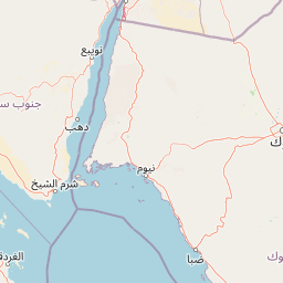
Map view of Ras Muhammad National Park

Use this park location map to pinpoint Ras Muhammad National Park in Egypt, understand its exact geographic position, and read its mapped placement within the surrounding landscape more clearly.

Pigeon | © OpenStreetMap contributors

Location context for Ras Muhammad National Park

South Sinai Governorate
Park atlas

Expand beyond Ras Muhammad, comparing protected areas and their mapped geography across the Sinai Peninsula and wider Red Sea region.

Compare National Parks and Protected Areas Near Ras Muhammad National Park, Sinai Peninsula
Browse national parks and protected areas near Ras Muhammad National Park, expanding your discovery into the diverse marine and desert landscapes of the Sinai Peninsula and Red Sea region. Comparing these protected areas offers valuable atlas context, revealing regional conservation patterns and ecosystem protection efforts across similar coastal and terrestrial terrain.
Protected areaSouth Sinai Governorate

Nabq Protected Area: South Sinai Governorate Protected Landscape and Regional Geography

Explore its mapped terrain and protected area context.

Nabq Protected Area offers a distinct view into Egypt's protected landscapes, situated within the South Sinai Governorate. This detailed page provides an atlas-style perspective on its geographic setting, allowing for structured exploration of its mapped boundaries and its role within the regional context. Understand the unique natural terrain and protected area characteristics that define this significant Egyptian site.

Area
600 km²
Established
1992
IUCN
VI
Relief
Mountain
National park

Makhtesh Ramon National Park: Israel's Premier Erosion Cirque & Geological Wonder

Discover dramatic desert terrain and ancient, colorful rock formations.

Makhtesh Ramon National Park in Israel's Negev Desert is the world's largest erosion cirque, a vast 40-kilometer depression revealing millions of years of geological history. Its striking landscape features colorful clay hills, ancient volcanic remnants, fossil beds, and unique sandstone formations, making it an unparalleled destination for understanding Earth's past through its protected natural terrain. Explore the mapped boundaries and regional context of this extraordinary desert formation.

Relief
Mountain
Climate
Arid
Access
Moderate access
Scope
Terrestrial
Watercolor illustration of a canyon with winding river, mountains, and rolling hills
National parkIsrael

Ein Avdat National Park: A Spectular Desert Oasis and Protected Landscape in Israel

Explore its unique springs, waterfalls, and ancient Nabatean and Byzantine history.

Ein Avdat National Park showcases a rare desert oasis environment, a starkly beautiful protected landscape where natural springs emerge from the Negev's arid terrain. This park is celebrated for its dramatic waterfalls, deep pools, and the preserved remnants of ancient human habitation, including a remarkable Byzantine cave monastery carved directly into the canyon walls. Its geography, shaped by the Nahal Zin wadi, provides a vivid study in desert ecosystems and their capacity for supporting life and history over millennia, making it a key site for understanding landscape context in Israel.

Area
4.8 km²
IUCN
V
Relief
Mixed relief
Climate
Arid
Watercolor illustration of a mountainous landscape with multiple colored terrain layers
Biosphere reserveJordan

Dana Biosphere Reserve: Mapped Biosphere Reserve in Jordan's Geography

Explore protected landscape boundaries and regional context.

Dana Biosphere Reserve is a critical protected landscape in Jordan, recognized for its significant geographic features and ecological value. This page offers detailed insights into its mapped boundaries and its place within the broader regional geography of the Middle East. It serves as an essential resource for understanding the park's protected-area identity and its contribution to Jordan's natural heritage, facilitating a deeper atlas-driven exploration of its terrain and conservation significance.

Area
308 km²
Established
1989
Relief
Mixed relief
Scope
Terrestrial
Watercolor illustration showing a winding river through green hills with distant trees under a light sky
National park

Eshkol National Park: Desert Wetland Oasis with Archaeological Significance in Southern Israel

Mapped protected area featuring Ein HaBesor spring and Besor valley landscapes.

Eshkol National Park showcases a rare desert wetland environment sustained by the significant Ein HaBesor spring in Israel's Northern Negev. This protected natural area offers a distinctive landscape where water nourishes lush vegetation against the backdrop of arid terrain. Beyond its ecological value, the park encompasses archaeological remnants, including the mound of Khirbet Shalala, providing a rich geographical and historical discovery context within the Besor Stream basin.

Area
3.54 km²
Relief
Lowland
Climate
Arid
Access
Easy access
Nature reserveJordan

Wadi Mujib Nature Reserve: Explore Jordan's Dramatic Canyon Protected Landscape

Discover mapped boundaries and arid biodiversity within this unique rift valley gorge.

Wadi Mujib Nature Reserve represents a significant protected landscape in Jordan, celebrated for its deep desert canyon and dramatic slot canyon terrain. Situated in the Dead Sea region, this reserve protects a remarkable range of geography, from its lowest points near the Dead Sea to surrounding mountain terrain. Its status as a UNESCO biosphere reserve highlights its importance for arid biodiversity and its role as a migratory bird flyway, offering a distinct atlas-level discovery of Jordan's natural heritage.

Area
212 km²
Established
1987
IUCN
IV
Relief
Mountain
Watercolor painting of rolling hills with pink, green, and purple hues
National parkIsrael

Ashkelon National Park: Ancient Coastal Protected Landscape and Archaeological Atlas

Explore mapped ruins, Fatimid walls, and Mediterranean coastal geography.

Ashkelon National Park in Israel offers a unique dive into ancient urban development, preserving layers of history from multiple civilizations along the Mediterranean coast. This protected area features landmark archaeological discoveries, including the Middle Bronze Age gate and extensive Roman ruins, all situated within a distinct coastal landscape. Understanding its mapped boundaries and the progression of its terrain provides critical context for appreciating this significant heritage site's geographic and historical importance.

IUCN
V
Relief
Lowland
Climate
Mediterranean
Access
Access unknown
National parkIsrael

Castel National Park: A National Park for Geographic Discovery in Israel

Investigate the mapped protected landscape and regional terrain.

Castel National Park represents a key protected area within Israel, focusing on the discovery of its mapped terrain and geographic identity. As a national park, it serves as a crucial entity for understanding regional conservation landscapes and the distribution of protected areas across Israel. This detailed view allows for focused exploration of the park's boundaries and its contribution to the country's natural heritage, offering valuable context for atlas-based geographical inquiry.

Relief
Mountain
Climate
Mediterranean
Scope
Terrestrial
Water
No major water

Common questions about visiting, size, designation, and location context for Ras Muhammad National Park

Ras Muhammad National Park FAQs for park facts, access, geography, and protected area context
Find quick answers about Ras Muhammad National Park, including protected-area facts, park geography, trail and visitor context, and how the park fits into its surrounding country and regional landscape.
MoriAtlas Explorer

Continue Your Protected Areas Search Across the Global Atlas

Deepen your exploration by continuing the structured search for national parks and protected areas worldwide. Utilize the comprehensive filtering capabilities to compare different conservation landscapes and refine your understanding of global park geography. Discover more about the distribution and characteristics of protected natural areas.

Global natural geography