

Mori Atlas logo
Protected areaSan Matías–San Carlos Protection Forest

Mapping the dramatic transition from Andean cloud forest slopes to the vibrant Amazonian lowlands.

San Matías–San Carlos Protection Forest: An Essential Protected Area in the Pasco Region of Central Peru

(Bosque de Protección San Matías-San Carlos)

San Matías–San Carlos Protection Forest serves as a critical highland corridor in the Pasco Region of central Peru, guarding steep watersheds and preventing soil erosion. This protected landscape encompasses a diverse altitudinal gradient, where mossy cloud forest transitions into lowland Amazonian rainforest. By safeguarding essential ecological connectivity for species and respecting the traditional territories of the Ashaninka and Yanesha peoples, the forest forms an integral component of the regional conservation architecture.

cloud forestYungaswatershed protectionbiosphere reserveindigenous territoryAndean Amazon transition
A flat-style digital illustration of a mountain landscape; in the foreground are stylized green plants, followed by a dense forest leading to a winding river that flows toward large, colorful mountains under a soft-toned sky.

San Matías–San Carlos Protection Forest

Protected area

Park overview

Structured park overview, official facts, and landscape profile for San Matías, San Carlos Protection Forest

San Matías, San Carlos Protection Forest park facts, protected area profile, and essential visitor context

Review the core facts for San Matías, San Carlos Protection Forest, including designation, size, terrain, visitor scale, habitats, and operating context in one park-focused overview.

About San Matías, San Carlos Protection Forest

The San Matías–San Carlos Protection Forest is one of Peru's principal forested reserves in the Pasco Region, where the eastern slopes of the Andes descend toward the Amazon basin. Covering roughly 1,458 square kilometres, the reserve was established in 1987 by the Peruvian state to protect soils and watersheds, shielding towns, agricultural land, and regional infrastructure from flash floods, huaycos, and severe stream-driven erosion that frequently affect the central Andean foothills.

The terrain of the protection forest spans a remarkable gradient, beginning around 300 metres in the lowland rainforests and rising to approximately 2,250 metres in cloud forest environments. This altitudinal range places the reserve within both the Peruvian Yungas and the Ucayali moist forests ecoregions, combining hot, humid lowland forests with cool, mossy, epiphyte-laden upper montane forests. Ferns, orchids, bromeliads, and other epiphytes thrive in the persistent moisture of the canopy, while commercially and medicinally important species, including mahogany and cat's claw, contribute to the forest's broader natural value.

Biogeographically, the reserve functions as a highland habitat corridor that connects the Andean cordillera with the surrounding Amazonian lowlands. Its position within the Oxapampa-Asháninka-Yánesha Biosphere Reserve amplifies its role as a connectivity node, allowing high-elevation wildlife to move along the eastern Andean front and supporting populations of spectacled bears, northern pudus, jaguars, giant otters, primates, and a rich avifauna that includes the Andean cock-of-the-rock.

Equally important is the cultural dimension of the protected area. The forest was designed to allow for the maintenance and development of the cultural values of native communities such as the Ashaninkas and the Yaneshas, both of whom consider parts of this forest integral to their identity, livelihoods, and traditional land use. This blend of ecological, hydrological, and cultural function sets San Matías–San Carlos apart as a protection forest whose significance extends well beyond its boundary lines.

Quick facts and research context for San Matías, San Carlos Protection Forest

Location: Pasco Region, central Peru, within the transition between the Peruvian Yungas and Ucayali moist forests ecoregions. Established: 1987 as a national protection forest under Peruvian classification, later incorporated into the Oxapampa-Asháninka-Yánesha Biosphere Reserve. IUCN category: VI, a protected area with sustainable use of natural resources. Approximate area: about 1,458 square kilometres, spanning elevations from roughly 300 to 2,250 metres. Key functions: soil and water protection, habitat connectivity between the Andes and the Amazon lowlands, and maintenance of Ashaninka and Yanesha cultural values.

Protection and recognition

Examine the terrestrial protection scope and documented conservation parameters.

San Matías–San Carlos Protection Forest Protection Status and Scope

San Matías–San Carlos Protection Forest maintains a documented terrestrial protection scope within official conservation records. Structured details outline the recognized management boundaries and administrative status for this protected natural area.

Protection details

Protection scope
Terrestrial
Park context

Deeper park guide and search-rich context for San Matías, San Carlos Protection Forest

San Matías, San Carlos Protection Forest history, landscape, wildlife, and travel context

Explore San Matías, San Carlos Protection Forest through its history, landscape character, ecosystems, wildlife, conservation priorities, cultural context, and seasonal travel timing in a structured park guide built for atlas discovery and search intent.

Why San Matías, San Carlos Protection Forest stands out

San Matías, San Carlos is best known as a cloud forest protection corridor where the eastern Andes meet the Amazon basin. The reserve exists to safeguard steep watersheds from erosion and flooding, while also preserving a continuous block of highland habitat for species such as the spectacled bear, the northern pudu, and the Andean cock-of-the-rock. The forest is equally distinguished by its place within the Oxapampa-Asháninka-Yánesha Biosphere Reserve, which links it to neighboring protected areas, and by its strong cultural significance, since the protection forest was created in part to support the traditional lands and cultural continuity of the Ashaninka and Yanesha peoples.
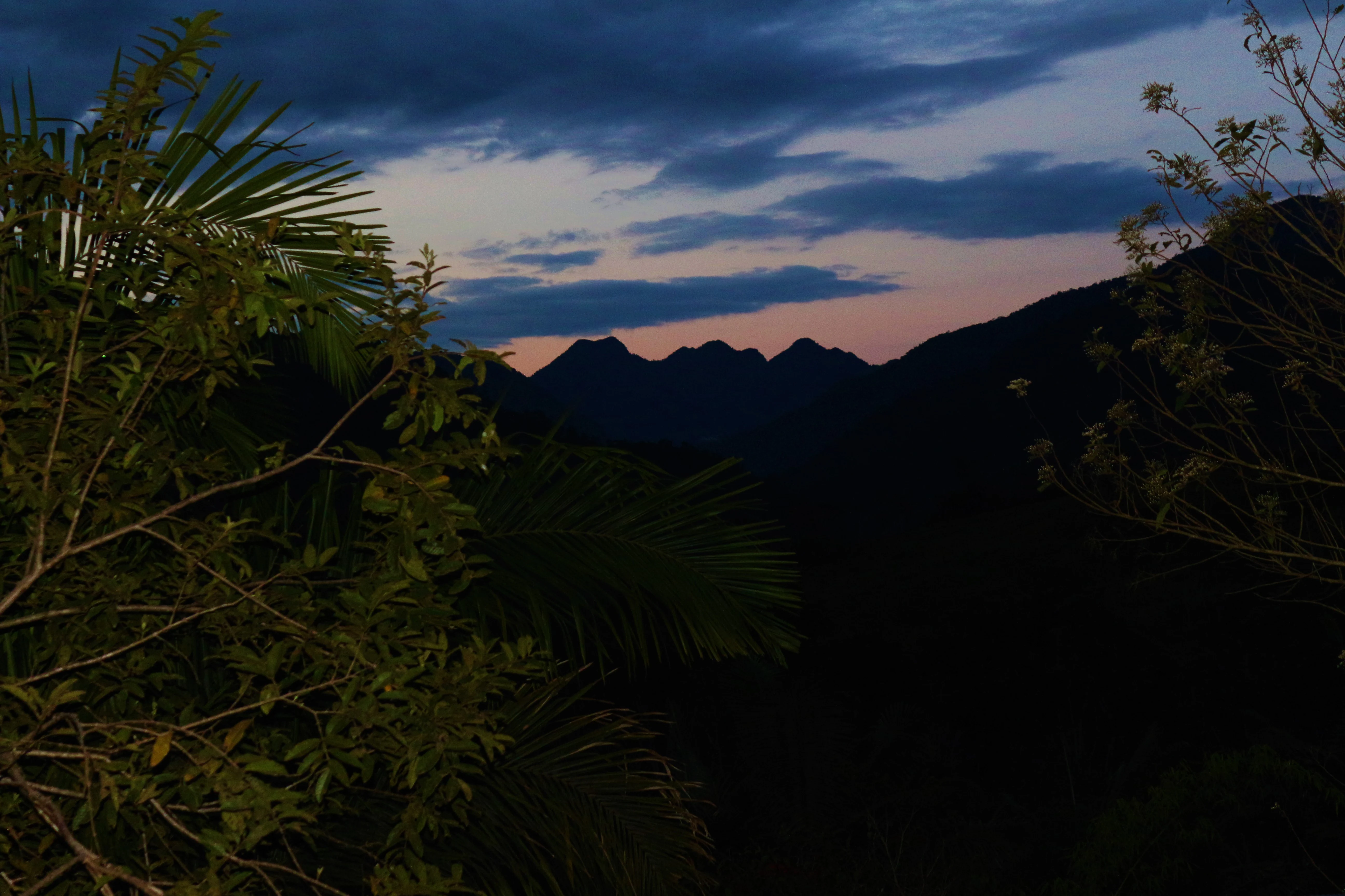
A dark, silhouetted mountain ridgeline against a twilight sky with pink and blue clouds, framed by lush foreground vegetation.
Silhouetted mountain range at dusk within the San Matías, San Carlos Protection Forest.

San Matías, San Carlos Protection Forest history and protected-area timeline

The San Matías–San Carlos Protection Forest was formally established in 1987 as a national forest reserve under Peruvian environmental and forestry authorities. Its creation reflected growing recognition in the late twentieth century that the steep, rainfall-rich eastern Andean slopes of Pasco were producing severe erosion, huaycos, and flooding events that threatened downstream agricultural lands, settlements, and infrastructure.

From the outset, the reserve was conceived not simply as a conservation area but as a protective buffer. The Peruvian state used the protection forest category to permanently safeguard soils and watersheds, while still permitting forms of sustainable use compatible with the long-term integrity of the landscape.

In later years, the protection forest was integrated into the larger Oxapampa-Asháninka-Yánesha Biosphere Reserve, a designation that reframed its role from an isolated watershed forest into a central node of a broader conservation landscape. Through this biosphere linkage, San Matías–San Carlos became an essential corridor for highland habitat connectivity between Andean ecosystems and the Amazon lowlands, while still serving its original hydrological and cultural objectives.

San Matías, San Carlos Protection Forest landscape and geographic character

San Matías–San Carlos occupies a dramatic transition zone where the Andes give way to the Amazon basin. The topography is defined by steep, dissected slopes carved by rivers descending toward the Pichis and Palcazu sub-basins. Elevations range from roughly 300 metres in the lower, warmer forests to around 2,250 metres in the higher, cooler forests, producing a compressed but exceptionally diverse topography.

The landscape alternates between narrow valleys, fast-flowing streams, and ridges covered by continuous forest cover. Ridgelines and upper slopes remain cloaked in dense forest that moderates runoff, while the lower valleys concentrate the erosive force of rainfall during the wet season. This structurally complex terrain is precisely what motivated the original protection designation, as the forest cover is essential to slowing water movement, stabilizing soils, and preventing catastrophic huaycos.

The reserve's visual character shifts dramatically with altitude. Lower portions exhibit tall lowland rainforest, with broadleaf canopies and relatively open understoreys. As elevation increases, the forest transitions into cloud forest: shorter trees bent by persistent mist, trunks wrapped in mosses, and canopies draped with ferns, orchids, and bromeliads. The combination of continuous canopy cover, rugged terrain, and atmospheric humidity gives the protection forest a deeply layered, quintessentially Yungas character.

San Matías, San Carlos Protection Forest ecosystems, habitats, and plant life

Ecologically, San Matías–San Carlos falls within two of South America's most biodiverse ecoregions. At lower elevations, the reserve carries elements of the Ucayali moist forests, with tall broadleaf species characteristic of the western Amazon basin. As elevation increases, the forest grade shifts sharply into the Peruvian Yungas, where montane and cloud forest communities dominate. This meeting of ecoregions within a single protected area creates a strong mosaic of habitats over a relatively short horizontal distance.

Vegetation patterns reflect the moisture regime of the eastern Andean slope. Lower forests are structured around tall emergent trees and dense mid-canopy layers, while the cloud forest belt is defined by stunted, moss-laden trees, abundant epiphytes, and a continuous understorey of ferns, herbs, and shrubs. Orchids, bromeliads, and other epiphytic plants are characteristic of the upper forests, where nearly year-round humidity supports their growth on trunks, branches, and even road cuttings.

Among the flora, the reserve includes commercially valuable hardwoods such as mahogany, as well as medicinal species of regional importance, including cat's claw. These plants reflect both the biological richness of the Yungas cloud forests and the long-standing relationship between forest species and human communities in the region, particularly the Ashaninka and Yanesha peoples.

The reserve's ecological role is closely tied to its hydrology. Its soils and forests recharge the waters that feed the Pichis and Palcazu river sub-basins, making the protection forest a critical regulator of downstream water quantity and quality as well as a refuge for biodiversity within an otherwise heavily altered Andean landscape.

San Matías, San Carlos Protection Forest wildlife and species highlights

The San Matías–San Carlos Protection Forest supports a particularly rich mixture of Andean and Amazonian wildlife, made possible by the altitudinal gradient that compresses very different habitats into a single reserve. Among the most iconic mammals is the spectacled bear, South America's only native bear species, which depends heavily on this kind of elevated, forested terrain. The northern pudu, one of the world's smallest deer, also occurs here, reflecting the presence of dense understorey and bamboo-rich habitats typical of the Yungas.

Larger carnivores and aquatic mammals are also part of the forest's fauna. Jaguars range through the lower forested zones, while giant otters are associated with the rivers and larger streams that drain the reserve, including tributaries contributing to the Pichis and Palcazu river systems. Primate communities typical of the eastern Andean foothills are also present, contributing to the forest's role as a refuge for the region's arboreal mammals.

Birdlife is a major attraction of the reserve. The Andean cock-of-the-rock, with its characteristic plumage and display behavior, is emblematic of the Yungas cloud forests and inhabits the reserve's mid-elevation forests. The combination of lowland and montane forest within the protection forest supports diverse Neotropical bird assemblages more generally, making the area significant for regional avian diversity.

Taken together, the distribution of highland specialists such as the spectacled bear and northern pudu, alongside lowland species such as jaguars, giant otters, and primates, demonstrates how the reserve's landscape mosaic supports wildlife that would not persist in either pure Andean or pure Amazonian habitat alone.

San Matías, San Carlos Protection Forest conservation status and protection priorities

San Matías–San Carlos plays a distinctive role in Peru's protected-area system. Classified as IUCN Category VI, it is a protected area with sustainable use of natural resources: strict in its protective purpose, yet flexible enough to accommodate forms of resource use that do not undermine the forest's hydrological and ecological functions. This category reflects the reserve's central mission of soil and water protection rather than wilderness preservation alone.

The conservation value of the reserve lies primarily in its watershed function. By maintaining continuous forest cover on steep, erosion-prone slopes, it reduces the frequency and severity of huaycos, flash floods, and streambank erosion that would otherwise affect downstream towns, infrastructure, and farmland in the Pasco Region and beyond.

In addition, the reserve is a key component of the Oxapampa-Asháninka-Yánesha Biosphere Reserve, a landscape-scale designation that integrates multiple protected areas, buffer zones, and areas of cultural importance. Within this biosphere, San Matías–San Carlos functions as a corridor linking Andean montane habitats with Amazon lowland ecosystems, allowing species to move, disperse, and maintain viable populations across the eastern Andean front.

The conservation significance of the forest is therefore both local, in terms of hydrological and soil protection, and regional, in terms of maintaining connectivity and biocultural diversity within one of Peru's most important Andean-Amazonian transition zones.

San Matías, San Carlos Protection Forest cultural meaning and human context

The San Matías–San Carlos Protection Forest was created in part to safeguard the cultural values of the indigenous communities living within and around it. Both the Ashaninka and the Yanesha have deep historical ties to the forests, rivers, and foothills of the central eastern Andes, and the protection forest supports the continuity of their traditional livelihoods, knowledge systems, and community life.

This cultural dimension is formally embedded in the reserve's objectives. Unlike purely ecological reserves, the protection category specifically allows for the maintenance and development of indigenous cultural values, recognizing that long-term ecological integrity in this landscape is inseparable from the well-being of the communities who have inhabited it.

The reserve's inclusion within the Oxapampa-Asháninka-Yánesha Biosphere Reserve further strengthens this linkage, situating San Matías–San Carlos within a broader framework that integrates biodiversity conservation with indigenous land use and regional cultural identity in the Pasco Region.

Top sights and standout views in San Matías, San Carlos Protection Forest

San Matías–San Carlos stands out for combining watershed protection, biodiversity conservation, and indigenous cultural stewardship within a single landscape. Its position bridging the Peruvian Yungas and Ucayali moist forests ecoregions produces an unusually rich habitat gradient, ranging from lowland rainforest at around 300 metres to mossy cloud forest at approximately 2,250 metres.

The reserve also contributes to the regional conservation architecture through its role within the Oxapampa-Asháninka-Yánesha Biosphere Reserve, where it acts as a connectivity corridor for highland species such as the spectacled bear and the Andean cock-of-the-rock, while supporting jaguars, giant otters, primates, and a diverse cloud forest flora including mahogany and cat's claw.

Best time to visit San Matías, San Carlos Protection Forest

The climate of San Matías–San Carlos is shaped by the eastern Andean slope, with abundant rainfall year-round and persistently humid conditions in the cloud forest zone. The dry season typically offers more stable weather, clearer skies, and easier access to trails, while the wet season intensifies the forest's mist and fog but also heightens the erosive processes that the reserve was created to mitigate.

For visitors focused on birdwatching and cloud forest scenery, periods with less continuous rain generally provide better conditions, since wildlife observation and visibility in mossy upper-elevation forests improve when canopy-level mist is less dense. The forest's appeal, however, is strongly tied to its humid character, so visitors should expect a moist environment in any season and plan accordingly.
Monthly climate preview

Long-term representative monthly temperature and precipitation patterns across the protected terrain

San Matías–San Carlos Protection Forest Climate Normals and Annual Weather Rhythm

Historical data records monthly average temperatures spanning roughly twenty-four to twenty-seven degrees Celsius alongside recorded precipitation variations from zero point four to two point six millimeters per day. Accessing the comprehensive twelve-month profile reveals complete meteorological breakdowns and deeper statistical comparisons for this protected region.
Annual mean25 °C
24 °C27 °C
Jan24°
Feb24°
Mar24°
Apr24°
May25°
Jun24°
Jul25°
Aug26°
Sep27°
Oct26°
Nov25°
Dec24°
Warmest month
September

26.8 °C

Coolest month
March

23.8 °C

Wettest month
February

2.6 mm/day

Driest month
August

0.4 mm/day

Park location guide

Geography guide, regional context, and park location map for San Matías, San Carlos Protection Forest

San Matías, San Carlos Protection Forest park geography, regions, and map view in Peru

Understand where San Matías, San Carlos Protection Forest sits in Peru through a broader geographic reading of the surrounding landscape, nearby location context, and its mapped position within the national park landscape.

How San Matías, San Carlos Protection Forest fits into Peru

Peru is a megadiverse country in western South America with a population of over 34 million. It spans three distinct geographic regions: the Pacific coastal desert in the west, the Andes mountains running north to south, and the Amazon rainforest in the east. The country has one of the longest histories of civilization in the world, tracing back to the Caral-Supe civilization of the 10th millennium BCE, and was home to the Inca Empire before Spanish colonization in the 16th century.

Wider geography shaping San Matías, San Carlos Protection Forest in Peru

Peru is located in western South America along the Pacific coast. The country encompasses three major geographic regions: the coastal desert plains along the Pacific, the Andes mountain range extending from north to southeast, and the Amazon basin rainforest in the eastern interior. It shares borders with Ecuador and Colombia to the north, Brazil to the east, Bolivia to the southeast, and Chile to the south.

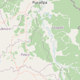
Map view of San Matías, San Carlos Protection Forest

Use this park location map to pinpoint San Matías, San Carlos Protection Forest in Peru, understand its exact geographic position, and read its mapped placement within the surrounding landscape more clearly.

Pigeon | © OpenStreetMap contributors

Location context for San Matías, San Carlos Protection Forest

Pasco Region
Recorded earthquake history

Examine the Earthquake History of San Matías–San Carlos Protection Forest

Explore a detailed record of seismic activity associated with the San Matías–San Carlos Protection Forest. MoriAtlas provides this historical catalogue to help users understand recorded events, magnitudes, and epicentre proximity within the regional geography of the Pasco protection corridor.

San Matías–San Carlos Protection Forest Earthquake History

Catalogued events

275 events

Strongest magnitude

Magnitude 6.7

Most recent event

Aug 9, 2026

This history includes earthquakes recorded inside the park or within 50 km of its borders

Visualizing the rugged cloud forest terrain and protected habitats of central Peru

San Matías–San Carlos Protection Forest Photos: Landscapes and Scenery

Visual documentation captures the steep mountain slopes, fast-flowing river valleys, and mossy cloud forest environments defining San Matías–San Carlos Protection Forest. Examining these protected-area habitats and altitudinal transitions provides a clearer understanding of the ecological character connecting the Andes to the Amazon basin.

A dark, silhouetted mountain ridgeline against a twilight sky with pink and blue clouds, framed by lush foreground vegetation.

Park atlas

Compare regional protected areas and connected conservation corridors across the eastern slopes

Other Parks Near San Matías–San Carlos Protection Forest and Surrounding Protected Landscapes

Explore protected areas near San Matías–San Carlos Protection Forest to examine similar cloud forest reserves and regional conservation corridors. Comparing adjacent highland habitats provides broader context on Andean Amazon transition zones and regional watershed protection.
National parkPasco Region
Park boundaries overlap#1 closest

Northwest

Yanachaga, Chemillén National Park: Protected Area in Pasco Region, Peru

Mapped terrain, Pleistocene refuge, and rich biodiversity.

Yanachaga, Chemillén National Park, a national park situated in Peru's Pasco Region, preserves over 122,000 hectares of mountainous cloud forest and rainforest ecosystems. Its landscape is characterized by dramatic canyons and steep forested slopes, creating significant altitudinal variation from 460 to 3,643 meters. Recognized as a Pleistocene refuge, the park shelters ancient forest remnants and harbors exceptional biodiversity, including hundreds of bird species and iconic mammals, offering rich context for geographic and protected-area exploration.

Area
1,220 km²
Established
1986
IUCN
II
Relief
Mountain
Protected areaOxapampa Province
Park boundaries overlap#2 closest

Northwest

Yanesha Communal Reserve: Geography and Protected Area Context in Oxapampa Province

A vital transition zone between the Andes and the Amazon

Gain insight into the physical character of Yanesha Communal Reserve, where humid tropical forests and river channels converge to form a complex ecosystem. This protected area offers a look at how sustainable land use and conservation intersect within the Palcazu River basin. Browse the geographic boundaries and mapped landscape features that define this essential region in central Peru.

Area
347.45 km²
Established
1988
IUCN
VI
Scope
Terrestrial
A soft watercolor illustration showing rolling green hills and distant mountain peaks in pale yellow and green tones, with a minimalist white background.
Wildlife reservePeru
14 km away#3 closest

Northeast

El Sira Communal Reserve: Geographic Profile and Protected Landscape Context in Peru

Analyzing the Sira Mountain range and regional watershed boundaries

El Sira Communal Reserve sits at the intersection of the Andes and the Amazon, protecting a vast mosaic of habitats across Huánuco, Pasco, and Ucayali. Its geography is defined by deep river valleys, mountain ridges, and a significant altitudinal range that supports diverse wildlife communities. This resource provides a detailed look at the boundaries, terrain, and ecological importance of this major Peruvian protected area.

Area
6,164.13 km²
Established
2001
IUCN
VI
Relief
Mountain
National parkPeru
79 km away#4 closest

Southeast

Otishi National Park: A Protected National Park Landscape in Peru's Geography

Explore the mapped boundaries and regional landscape of Otishi National Park.

Otishi National Park represents a significant protected area within Peru, offering a unique lens through which to explore regional geography and conservation landscapes. As a designated national park, it highlights the mapped boundaries and the natural terrain that defines this part of South America. Understanding Otishi National Park provides essential context for regional park discovery and the broader atlas of protected lands in Peru.

Area
3,059.73 km²
Established
2003
IUCN
II
Relief
Mountain
National parkHuánuco Region
97 km away#5 closest

Northwest

Tingo María National Park: National Park Protected Landscape in Huánuco Region, Peru

Atlas exploration of park boundaries and regional geography.

Investigate Tingo María National Park, a key protected area situated in the Huánuco Region of Peru. This national park designation signifies its importance for understanding the country's natural landscapes and mapped geography. Explore its protected territory and discover its place within the regional atlas.

Area
47.778 km²
Established
1965
IUCN
II
Relief
Mountain
National parkPeru
132 km away#6 closest

North

Cordillera Azul National Park: A National Park for Geographic Discovery in Peru

Explore Peru's protected landscape and regional map context.

Cordillera Azul National Park serves as a dedicated entry point for understanding Peru's protected natural areas through a geographic lens. This park's identity is tied to its specific mapped boundaries and its contribution to the nation's diverse terrain. Focusing on Cordillera Azul National Park allows for detailed atlas exploration of its unique landscape context within western South America, providing factual data for geographic understanding.

Area
13,531.9 km²
Established
2001
IUCN
II
Relief
Mountain
A flat-style vector illustration of a mountain valley with a central blue lake, surrounding peaks, and a winding dirt path.
Protected landscapeLima Region
138 km away#7 closest

Southwest

Nor Yauyos-Cochas Landscape Reserve: Mapped Geography and Protected Andean Terrain

High-altitude glacial landscape and karst geology

Investigate the high-Andean environment of Nor Yauyos-Cochas Landscape Reserve, a protected area in the Lima Region spanning glacial lakes and deep valleys. Focus on the topographic diversity of the Pariacaca massif and the global significance of its subterranean karst features. This atlas provides a detailed spatial look at how these high-elevation ecosystems and traditional cultural landscapes integrate into the broader Peruvian geography.

Area
2,212.68 km²
Established
2001
IUCN
V
Relief
Mountain
Nature reservePeru
166 km away#8 closest

West

Cordillera Huayhuash Reserved Zone: Protected Mountain Geography and Andean Watersheds

High-altitude glacial terrain in central Peru

Cordillera Huayhuash Reserved Zone comprises a dense concentration of glacial peaks and highland basins. As a major source of water for both the Pacific coast and the Amazon, this protected area represents a unique geographic crossroads where ice fields and alpine puna support critical regional ecosystems in the heart of the Andes.

Area
675.9 km²
Established
2002
Relief
Mountain
Climate
Alpine

Common questions about visiting, size, designation, and location context for San Matías, San Carlos Protection Forest

San Matías, San Carlos Protection Forest FAQs for park facts, access, geography, and protected area context

Find quick answers about San Matías, San Carlos Protection Forest, including protected-area facts, park geography, trail and visitor context, and how the park fits into its surrounding country and regional landscape.
MoriAtlas Explorer

Continue Your Protected Areas Search Across the Global Atlas

Deepen your exploration by continuing the structured search for national parks and protected areas worldwide. Utilize the comprehensive filtering capabilities to compare different conservation landscapes and refine your understanding of global park geography. Discover more about the distribution and characteristics of protected natural areas.

Global natural geography