Mori Atlas logo
National parkSan Rafael National Park

Discover the mapped boundaries and regional setting of San Rafael National Park in Itapúa Department.

San Rafael National Park: National Park Protected Landscape & Geographic Context

(Parque Nacional San Rafael)

San Rafael National Park represents a key protected area within the Itapúa Department of Paraguay. As a designated national park, its primary role involves safeguarding specific natural landscapes and ecosystems. This page provides an atlas-focused perspective, detailing the park's geographic footprint and its place within the regional context, offering essential data for understanding its protected status and mapped boundaries.

Atlantic ForestImportant Bird AreaBiodiversity HotspotWetlandsGrasslandsJaguar Habitat

San Rafael National Park

National park

Park overview

Structured park overview, official facts, and landscape profile for San Rafael National Park

San Rafael National Park park facts, protected area profile, and essential visitor context
Review the core facts for San Rafael National Park, including designation, size, terrain, visitor scale, habitats, and operating context in one park-focused overview.

About San Rafael National Park

San Rafael National Park represents one of Paraguay's most important conservation priorities, protecting the largest remaining expanse of Atlantic Forest in the country within the Alto Paraná Lowland Atlantic Forest ecoregion. This forest type is considered particularly threatened within the broader Atlantic Forest biome, which historically covered much of southeastern South America but has been dramatically reduced by agricultural expansion. The park is situated in the upper Tebicuary River basin, occupying the San Rafael Hills where elevations range from 100 to 500 metres. Approximately 80% of the area remains forest-covered, though the landscape also includes broad stretches of natural grasslands and wetlands characteristic of Paraguay's mesopotamian grasslands in the northern portion of the park. The region experiences a subtropical climate with temperatures ranging from 17 to 23.8°C, with the hottest period from October through April and cooler months from May to September. Rainfall occurs throughout the year, averaging 2,100mm annually with the wettest months falling between October and February. The proposed park would connect with Caazapá National Park, though this ecological link has become tenuous due to deforestation in the intervening areas.

Quick facts and research context for San Rafael National Park

San Rafael National Park is located in southeastern Paraguay, spanning the Itapúa and Caazapá departments in the San Rafael Hills at elevations ranging from 100 to 500 metres above sea level. The protected area covers 69,304 hectares of Atlantic Forest, grasslands, and wetlands, representing the largest remaining fragment of this critically endangered forest type in Paraguay. The region experiences temperatures between 17 and 23.8°C with average annual rainfall of 2,100mm. Though officially declared as an Area Reserved for a National Park in 1992, the park's formal status remains pending, with all land currently in private ownership. The NGO Guyra Paraguay has purchased and manages 6,500 hectares within the proposed park boundary as a protected area.

Park context

Deeper park guide and search-rich context for San Rafael National Park

San Rafael National Park history, landscape, wildlife, and travel context
Explore San Rafael National Park through its history, landscape character, ecosystems, wildlife, conservation priorities, cultural context, and seasonal travel timing in a structured park guide built for atlas discovery and search intent.

Why San Rafael National Park stands out

San Rafael National Park is best known for being Paraguay's most significant Atlantic Forest remnant and one of the country's most biodiverse regions. The park hosts over 400 bird species, the greatest number of any site in Paraguay, including twelve globally threatened species such as the vinaceous-breasted amazon and black-fronted piping guan. It is recognized as an Important Bird Area by BirdLife International and supports populations of four globally threatened large mammals, including the jaguar and South American tapir. The park also represents a critical corridor in the Trinational Biodiversity Corridor connecting conservation units across Paraguay, Brazil, and Argentina.

San Rafael National Park history and protected-area timeline

San Rafael National Park was declared an Area Reserved for a National Park in 1992, with an initial area of approximately 78,000 hectares designated for protection. However, the formal establishment of the park has faced significant obstacles, primarily due to the fact that all land within the proposed boundary is privately owned, creating disputes over the designation and limiting effective conservation implementation. In 2002, the protected area status was changed to a managed resources reserve, equivalent to IUCN Category VI, though this reversal was itself reversed in 2005. As of now, a final decision regarding whether the park will be formally declared a national park or remain a managed resources reserve remains pending. The NGO Guyra Paraguay has played a critical role in conservation efforts within the area, purchasing approximately 6,500 hectares of land which it manages as a protected area, providing a core conservation zone within the larger proposed park boundary.

San Rafael National Park landscape and geographic character

The San Rafael National Park occupies the San Rafael Hills within the upper Tebicuary River basin in southeastern Paraguay. The terrain is characterized by gently rolling hills with elevations ranging from 100 to 500 metres above sea level, forming part of the broader Paraná Plateau region. The landscape features a complex mosaic of forest types, with tall humid forests dominating the areas closer to the Paraná River basin transitioning to lower, drier forests as the terrain slopes toward the Paraguay River basin. Approximately 80% of the park area remains covered in forest, representing the largest contiguous Atlantic Forest remnant in Paraguay. The northern portions of the park contain broad stretches of natural grasslands and wetlands, characteristic of the mesopotamian grassland ecosystem that extends across this region of the Paraguayan Chaco. The area sits within a transitional ecological zone that influences both the vegetation patterns and the biodiversity present.

San Rafael National Park ecosystems, habitats, and plant life

San Rafael National Park protects the Alto Paraná Lowland Atlantic Forest, one of the most threatened forest types within the Atlantic Forest biome. This ecoregion represents a critical habitat for maintaining biodiversity in Paraguay, as the Atlantic Forest has been dramatically reduced across its historical range. The park sits at a biogeographic crossroads, serving as a transition zone between the more humid forests of the Paraná basin and the drier forest types found in the Paraguay River basin. This ecological positioning contributes to the extraordinary diversity of plant and animal species found within the area. The combination of forest, grassland, and wetland habitats creates a heterogeneous landscape that supports a wide variety of ecological communities. Climate conditions include annual rainfall of approximately 2,100mm distributed throughout the year, supporting lush forest growth and maintaining the wetland systems that are integral to the park's ecological character.

San Rafael National Park wildlife and species highlights

San Rafael National Park supports exceptional biodiversity, particularly avifauna, with over 400 bird species recorded, the highest total of any site in Paraguay. Twelve bird species found in the park are globally threatened, including the vinaceous-breasted amazon and black-fronted piping guan. The park has been designated an Important Bird Area by BirdLife International due to its significance for bird conservation. Notable bird species present include the helmeted woodpecker, russet-winged spadebill, cock-tailed tyrant, and saffron-cowled blackbird. Mammalian fauna includes the jaguar and South American tapir, with the park supporting four globally threatened large mammal species. The combination of forest, grassland, and wetland habitats creates diverse ecological niches that support this remarkable concentration of wildlife, making San Rafael Paraguay's most important area for biodiversity conservation.

San Rafael National Park conservation status and protection priorities

San Rafael National Park represents a critical conservation priority due to the exceptional biodiversity found within its boundaries and the extreme threat level facing the Atlantic Forest ecoregion. The park's designation as an Important Bird Area by BirdLife International recognizes its global significance for bird conservation, particularly for the twelve globally threatened species that depend on its habitats. The proposed Trinational Biodiversity Corridor, which the park would form part of, aims to restore forest connectivity between conservation units in Brazil, Paraguay, and Argentina, a crucial strategy for maintaining ecological processes across the Upper Paraná ecoregion. Conservation challenges are significant, as over 22% of the original area had been modified by 2007, with ongoing pressure from large-scale intensive agriculture and slash-and-burn farming practices. NGO Guyra Paraguay's land purchase and management of 6,500 hectares provides an important core protected area within the proposed park boundary, demonstrating a model for conservation through private land acquisition in a region where most land remains in private hands.

San Rafael National Park cultural meaning and human context

San Rafael National Park is situated in the departments of Itapúa and Caazapá in southeastern Paraguay, a region with historical ties to Jesuit missionary activity during the colonial period. The area's name references the San Rafael Hills, a geographic feature that has long been part of the regional landscape. The park exists within a broader landscape where agricultural expansion has dramatically altered the natural environment, with communities both dependent on and impacted by the conversion of forest to farmland. The proposed trinational corridor context also reflects the cross-border nature of Atlantic Forest conservation, recognizing that effective biodiversity protection requires cooperation across national boundaries. The challenges facing the park reflect broader tensions between conservation goals and development pressures that characterize much of Paraguay's eastern region, where fertile soils have driven extensive agricultural conversion.

Top sights and standout views in San Rafael National Park

San Rafael National Park stands as Paraguay's most significant protected area, protecting the largest remaining Atlantic Forest fragment and supporting the country's highest biodiversity concentration with over 400 bird species and four globally threatened large mammals including jaguar and South American tapir. The park's location within the proposed Trinational Biodiversity Corridor positions it as a critical node in regional conservation networking. Its designation as an Important Bird Area by BirdLife International highlights global recognition of its avifauna significance, particularly for twelve globally threatened species. The area's transitional position between the Paraná and Paraguay River basins creates unique ecological character. Despite challenges to formal establishment, the NGO Guyra Paraguay's ownership and management of 6,500 hectares demonstrates tangible conservation progress.

Best time to visit San Rafael National Park

The optimal time to experience San Rafael National Park falls during the cooler dry season from May through September, when temperatures range from the lower end of the annual spectrum and conditions are more comfortable for exploration. The hottest period occurs from October through April, coinciding with the wet season when rainfall is most intense between October and February. Visitors interested in birdwatching may find the wet season particularly rewarding, as water-loving species congregate around wetlands and the grassland areas provide important habitat during this period. The park's year-round accessibility is somewhat complicated by its proposed status and private land ownership issues, requiring visitors to coordinate with local conservation organizations such as Guyra Paraguay to arrange access and ensure responsible visitation.

Park location guide

Geography guide, regional context, and park location map for San Rafael National Park

San Rafael National Park park geography, regions, and map view in Paraguay
Understand where San Rafael National Park sits in Paraguay through a broader geographic reading of the surrounding landscape, nearby location context, and its mapped position within the national park landscape.

How San Rafael National Park fits into Paraguay

Paraguay is a landlocked presidential republic in central South America with a population of approximately 6.4 million. Originally inhabited by the Guaraní people, it was colonized by Spain in the 16th century and gained independence in 1811. The country is notable for its strong Guarani cultural influence, economic growth driven by soybean and beef exports, and significant hydroelectric power generation. Asunción is both the capital and largest city.

Wider geography shaping San Rafael National Park in Paraguay

Paraguay is located in the central region of South America, completely landlocked but with Atlantic Ocean access via the Paraná-Paraguay Waterway. It borders Bolivia to the northwest and north, Brazil to the northeast and east, and Argentina to the southeast, south, and west. The terrain consists mostly of rolling plains and lowlands, with the Paraguay River dividing the country into eastern and western regions.

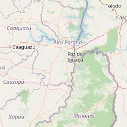
Map view of San Rafael National Park

Use this park location map to pinpoint San Rafael National Park in Paraguay, understand its exact geographic position, and read its mapped placement within the surrounding landscape more clearly.

Pigeon | © OpenStreetMap contributors

Location context for San Rafael National Park

Caazapá DepartmentItapúa Department
Park atlas

Trace surrounding Atlantic Forest remnants and regional protected landscapes across the Upper Paraná basin.

Discover More National Parks and Protected Areas Near San Rafael National Park, Paraguay
Browse a curated selection of national parks and protected areas geographically close to San Rafael National Park, tracing the broader Atlantic Forest and Upper Paraná ecoregions. Compare diverse protected landscapes, including wetlands, grasslands, and humid forests, to understand the connected conservation efforts across Paraguay and adjacent countries.
National parkParaguay

Ñacunday National Park National Park: Paraguay's Protected Landscape and Mapped Boundaries

Explore its unique geography and protected terrain.

Gain a precise understanding of Ñacunday National Park, a designated national park in Paraguay. This entry focuses on its role as a protected landscape, detailing its geographic attributes and mapped boundaries. It serves as a vital resource for users seeking specific information on the park's natural terrain and its contribution to Paraguay's conservation geography, facilitating structured discovery within the atlas.

Area
20 km²
Established
1993
Relief
Mixed relief
Climate
Subtropical
National parkMisiones Province

Iguazú National Park: Argentina's Misiones Province Protected Landscape Atlas

Explore mapped boundaries and regional geography.

Iguazú National Park serves as a key protected natural area situated within Misiones Province. This MoriAtlas entry details its mapped geographic boundaries, contributing essential context for understanding its landscape identity. Users can explore how this national park fits into the regional geography, providing a factual basis for detailed atlas-based study of protected lands and their unique terrain.

Area
677 km²
Established
1934
IUCN
II
Relief
Lowland
National parkParaguay

Ypoá National Park: Paraguay's Protected Wetland Landscape and Lake Ecosystem

Explore mapped boundaries and significant bird habitats in the Ñeembucú region.

Ypoá National Park is a critical protected area in Paraguay, renowned for its extensive wetland ecosystems dominated by Lake Ypoá. This national park encompasses a rich mosaic of marshlands, riparian forests, and aquatic vegetation, making it a significant habitat for numerous bird species, including several rare and endemic types. Its designation as a Ramsar Wetland underscores its ecological importance, offering a unique lens for understanding landscape context and protected-area geography within South America.

Area
1,000 km²
Established
1992
IUCN
II
Relief
Lowland
National parkCorrientes Province

Iberá National Park: National Park Atlas Exploration in Corrientes Province

Mapped protected area context and regional geography.

Delve into the atlas view of Iberá National Park, a designated national park situated in Corrientes Province, Argentina. This detailed entry clarifies the park's protected landscape identity and its contribution to the regional geography of northeastern Argentina. Understand its mapped boundaries and explore its significance as a conservation area within the Mesopotamia region.

Area
1,835 km²
Established
2018
IUCN
II
Relief
Lowland
National parkFormosa Province

Río Pilcomayo National Park: Protected Humid Chaco Wetland Landscape & Geography

Explore mapped boundaries and unique floodplain terrain in Formosa Province.

Río Pilcomayo National Park represents a significant protected natural area within Argentina's Formosa Province, characterized by the unique ecosystems of the Humid Chaco. The park's landscape is defined by extensive floodplains, marshes, lakes, and forests, all influenced by the Pilcomayo River's dynamic hydrological cycle. As a Ramsar site, it safeguards crucial habitats, including those for the endangered jaguar, and showcases iconic Caranday palm savannas. This detailed atlas entry provides insights into its mapped geography and the vital protected landscape it preserves.

Area
518.89 km²
Established
1951
IUCN
II
Relief
Lowland
National parkCorrientes Province

Mburucuyá National Park: National Park in Corrientes Province, Argentina

Iconic yatay palm savannas and diverse wetland ecosystems.

As a key national park within Argentina's Corrientes Province, Mburucuyá National Park offers a unique atlas-scale view of ecological convergence. It preserves expansive yatay palm savannas, critical wetland habitats within the Iberá Wetlands, and lush subtropical forests. The park's boundaries define an area where the Humid Chaco, Espinal, and Selva Paranaense biomes meet, creating a landscape of exceptional biodiversity and geographic significance for regional conservation and mapped exploration.

Area
176.82 km²
Established
2001
IUCN
II
Relief
Lowland
National parkChaco Province

Chaco National Park: Protected Landscape and Regional Geography Atlas

Explore mapped boundaries within the Eastern Chaco's unique ecosystem.

Chaco National Park is an important protected area in Chaco Province, Argentina, dedicated to preserving the unique Eastern Chaco ecosystem. Covering 150 square kilometers, its landscape comprises warm lowland terrain with scrubland, savanna, swamp areas, and scattered lakes. This national park is recognized for its efforts to conserve the distinctive quebracho forests and supports a rich array of wildlife, making it a key site for understanding regional protected-area geography and landscape context.

Area
150 km²
Established
1954
IUCN
II
Relief
Lowland
National parkArgentina

El Impenetrable National Park: A Protected National Park within Argentina's Geography

Explore its mapped boundaries and regional landscape context.

Delve into El Impenetrable National Park, a designated national park situated in Argentina. This entry provides critical geographic context, detailing its mapped protected area boundaries and its role within the national landscape. Understand its unique regional setting and explore its significance as a protected natural space for atlas-based discovery.

Area
1,289 km²
Established
2014
Relief
Lowland
Climate
Subtropical

Common questions about visiting, size, designation, and location context for San Rafael National Park

San Rafael National Park FAQs for park facts, access, geography, and protected area context
Find quick answers about San Rafael National Park, including protected-area facts, park geography, trail and visitor context, and how the park fits into its surrounding country and regional landscape.
MoriAtlas Explorer

Continue Your Protected Areas Search Across the Global Atlas

Deepen your exploration by continuing the structured search for national parks and protected areas worldwide. Utilize the comprehensive filtering capabilities to compare different conservation landscapes and refine your understanding of global park geography. Discover more about the distribution and characteristics of protected natural areas.

Global natural geography