Mori Atlas logo
Protected areaSantuario Orito Indí-Andé Fauna and Flora Sanctuary

Understand the mapped boundaries and regional setting of this Colombian protected landscape.

Santuario Orito Indí-Andé Fauna and Flora Sanctuary: Colombia's Protected Area Geography and Landscape Context

(Santuario de Flora Plantas Medicinales Orito Ingi-Ande)

Santuario Orito Indí-Andé Fauna and Flora Sanctuary represents a significant protected area within Colombia's diverse geography. This page serves as a focal point for understanding the sanctuary's protected landscape identity, its mapped boundaries, and its role within the broader South American atlas. Explore the geographic context and natural terrain that define this conservation area, providing essential data for landscape discovery and regional map exploration.

protected areamedicinal plantsAmazon forestAndean-Amazon transitionsouthern ColombiaPutumayo

Santuario Orito Indí-Andé Fauna and Flora Sanctuary

Protected area

Park overview

Structured park overview, official facts, and landscape profile for Santuario Orito Indí-Andé Fauna and Flora Sanctuary

Santuario Orito Indí-Andé Fauna and Flora Sanctuary park facts, protected area profile, and essential visitor context

Review the core facts for Santuario Orito Indí-Andé Fauna and Flora Sanctuary, including designation, size, terrain, visitor scale, habitats, and operating context in one park-focused overview.

About Santuario Orito Indí-Andé Fauna and Flora Sanctuary

Santuario Orito Indí-Andé Fauna and Flora Sanctuary represents a significant addition to Colombia's network of protected areas, established to safeguard a remarkable concentration of medicinal plant species in the country's Amazonian frontier region. The sanctuary occupies a strategically important position in the Putumayo and Nariño departments, two of Colombia's most biologically diverse territories where the Andes mountains descending from the east meet the vast Amazon rainforest. This transitional landscape creates heterogeneous habitats ranging from premontane forests on the Andean slopes to tropical humid forests in the lower foothills, supporting plant communities that have evolved under distinct ecological pressures and developed unique chemical defenses and medicinal properties over millennia. The decision to establish this protected area in 2008 reflected growing recognition among Colombian conservation authorities that the region's extraordinary plant diversity faced escalating threats from colonization, agricultural expansion, and infrastructure development. By creating a sanctuary focused specifically on medicinal flora, the Colombian government aimed to preserve both the ecological integrity of the landscape and the traditional knowledge systems that have historically relied on these plant resources.

Quick facts and research context for Santuario Orito Indí-Andé Fauna and Flora Sanctuary

The sanctuary is situated in the Amazonian foothills of southern Colombia, near the municipality of Orito in Putumayo Department and extending into Nariño Department. Established on June 12, 2008, it covers roughly 1,020 square kilometers of protected territory managed under Colombia's National Protected Areas System (SINAP). The area centers on the southern slopes of Cerro Patascoy, with the nearest major city being Pasto. The sanctuary holds IUCN category III status as a natural monument, reflecting its primary conservation focus on preserving outstanding natural features and ecosystem components, particularly medicinal plant species of regional and national significance.

Protection and recognition

Verifying terrestrial protection scope, boundary data, and documented management records.

Santuario Orito Indí-Andé Fauna and Flora Sanctuary Protection Status and Profile

Browse the documented terrestrial protection status and framework governing Santuario Orito Indí-Andé Fauna and Flora Sanctuary. Comparing verified conservation parameters helps researchers and explorers analyze the global network of national parks and ecological reserves.

Protection details

Protection scope
Terrestrial
Transboundary protection
No
Park context

Deeper park guide and search-rich context for Santuario Orito Indí-Andé Fauna and Flora Sanctuary

Santuario Orito Indí-Andé Fauna and Flora Sanctuary history, landscape, wildlife, and travel context

Explore Santuario Orito Indí-Andé Fauna and Flora Sanctuary through its history, landscape character, ecosystems, wildlife, conservation priorities, cultural context, and seasonal travel timing in a structured park guide built for atlas discovery and search intent.

Why Santuario Orito Indí-Andé Fauna and Flora Sanctuary stands out

The sanctuary is best known for its dedicated protection of medicinal plants, most notably the yoco vine (Paullinia), which has traditional uses among indigenous communities throughout the Amazon basin. The protected area serves as a living repository of plant species with documented medicinal properties, preserving them from agricultural expansion, deforestation, and other threats that have depleted similar ecosystems throughout the region. Beyond its botanical significance, the sanctuary protects a transitional zone where Andean cloud forests give way to Amazonian lowland forests, creating unique ecological conditions that support high levels of biodiversity and endemism.

Santuario Orito Indí-Andé Fauna and Flora Sanctuary history and protected-area timeline

The Santuario Orito Indí-Andé was officially established on June 12, 2008, through a decree that designated the area as a sanctuary of flora focused specifically on protecting medicinal plant species. The creation of this protected area emerged from a broader initiative by Colombia's National Parks unit (Parques Nacionales Naturales de Colombia) to expand protection for ecologically significant but previously unprotected zones in the Amazonian region. Prior to its establishment, the area faced increasing pressure from agricultural conversion, particularly for coca cultivation and pasture development, activities that threatened the delicate forest ecosystems and the medicinal plant populations they contained. The sanctuary's designation reflected input from local communities and environmental scientists who recognized the irreplaceable value of the region's plant diversity, including species with documented therapeutic properties used in both traditional medicine and potential pharmaceutical development. The management of the sanctuary falls under Colombia's Sistema Nacional de Áreas Protegidas (SINAP), which coordinates conservation efforts across federal, departmental, and municipal levels.

Santuario Orito Indí-Andé Fauna and Flora Sanctuary landscape and geographic character

The sanctuary occupies a dramatic landscape defined by the intersection of the Andes mountain range and the Amazon basin, with the southern slopes of Cerro Patascoy forming the ecological backbone of the protected area. Cerro Patascoy is a prominent mountain in the border region between Colombia and Ecuador, rising to significant elevations that create distinct altitudinal zones within the sanctuary. The terrain features steep slopes, narrow valleys, and numerous watercourses that drain toward the Amazon basin, contributing to the region's importance as a water catchment area. Forest cover ranges from dense cloud forest at higher elevations to more open canopy forest in the lower foothills, with the vegetation structure influenced by both elevation and the transitional nature of the ecosystem. The area receives substantial rainfall typical of the Amazonian foothills, supporting lush vegetation and maintaining the humid conditions essential for the survival of many medicinal plant species.

Santuario Orito Indí-Andé Fauna and Flora Sanctuary ecosystems, habitats, and plant life

The nature of this sanctuary is defined by its exceptional plant diversity and the ecological transition between Andean and Amazonian biomes. The protected area contains numerous plant species with documented medicinal properties, representing a living pharmacy that has supported indigenous and local communities for generations. The yoco plant (Paullinia), a climbing vine with stimulant properties, stands out as one of the most culturally significant species within the sanctuary, traditionally consumed by Amazonian peoples for its energizing effects. Beyond medicinal species, the forest supports a wide array of flora including numerous families of trees, epiphytes, ferns, and orchids that characterize healthy tropical forest ecosystems. The transitional nature of the landscape, where Andean cloud forests meet Amazonian lowland forests, creates unique conditions that support species from both biomes and often produces elevated levels of endemism in the plant communities.

Santuario Orito Indí-Andé Fauna and Flora Sanctuary wildlife and species highlights

While the sanctuary is most famous for its medicinal plant protection, the area also supports significant wildlife populations typical of Amazonian and Andean foothill ecosystems. The forests provide habitat for numerous bird species, including many that are characteristic of the regional avifauna in the Putumayo and Nariño border regions. Mammals likely present include species adapted to both forest strata, from ground-dwelling peccaries and tapirs to arboreal primates and small mammals. The presence of watercourses throughout the sanctuary supports aquatic and semi-aquatic species, while the diverse forest structure provides niches for countless invertebrate groups that form the base of the ecological food web. While specific species counts are not detailed in available sources, the general biodiversity of the region is well-documented, with the Putumayo and Nariño departments consistently ranking among Colombia's most species-rich areas.

Santuario Orito Indí-Andé Fauna and Flora Sanctuary conservation status and protection priorities

The establishment of Santuario Orito Indí-Andé represents a conservation priority for Colombia, addressing the need to protect both medicinal plant species and the broader ecosystem they depend upon. The sanctuary's category III IUCN designation as a natural monument reflects its focus on preserving outstanding natural features, in this case the remarkable concentration of medicinal plant species found within its boundaries. The protected area contributes to Colombia's broader conservation network by preserving a corridor of forest that connects higher-elevation Andean ecosystems with Amazonian lowland forests, supporting biodiversity conservation across multiple ecological zones. The protection of this area also helps preserve the traditional ecological knowledge associated with medicinal plants, as many species within the sanctuary have been used by indigenous communities for generations. Conservation challenges in the region include pressure from agricultural expansion, logging, and infrastructure development, making the protected status essential for long-term preservation of the area's unique natural values.

Santuario Orito Indí-Andé Fauna and Flora Sanctuary cultural meaning and human context

The sanctuary exists within a region of significant cultural importance, home to indigenous communities whose traditional knowledge of medicinal plants has been developed over centuries of interaction with the local ecosystem. The name Orito Indí-Andé reflects the indigenous heritage of the region, incorporating terms that connect to local cultural identity and the traditional relationship between communities and their environment. The Putumayo Department in particular has a complex history involving indigenous communities, historical exploitation during the rubber boom period, and more recent challenges related to armed conflict and coca cultivation. The establishment of the sanctuary represents an effort to recognize and protect the value of traditional knowledge about medicinal plants, ensuring that these resources remain available for future generations while providing alternative economic possibilities based on sustainable use and conservation.

Top sights and standout views in Santuario Orito Indí-Andé Fauna and Flora Sanctuary

The sanctuary stands out for its focused mission of protecting medicinal plant species in one of Colombia's most biodiverse regions, creating a protected area that preserves both ecological systems and traditional knowledge about plant-based medicine. The combination of Andean and Amazonian ecosystems within a single protected area creates remarkable habitat diversity, supporting species from two major biomes in a relatively compact territory. The presence of the yoco plant and other documented medicinal species provides the sanctuary with a distinctive conservation identity that distinguishes it from other protected areas in Colombia. The location near Pasto, the largest city in southern Colombia, makes the sanctuary relatively accessible for research and conservation activities while still maintaining the isolation necessary for effective protection.

Best time to visit Santuario Orito Indí-Andé Fauna and Flora Sanctuary

Visiting the sanctuary is best planned during the drier seasons typical of the region, which generally fall between December and March, when precipitation levels are lower and trail conditions are more favorable for exploration. However, visitors should be prepared for the humid conditions that characterize this Amazonian foothill region year-round, as rainfall can occur in any season given the transitional climate. The dry season often offers better opportunities for wildlife observation as animals concentrate around remaining water sources, while the wet season showcases the region's lush vegetation and full river systems. Temperature variations are minimal due to the equatorial location, with the primary environmental factor being elevation, which can bring cooler conditions at higher elevations within the sanctuary.

Monthly climate preview

Long-term temperature and precipitation patterns recorded across the representative park coordinate

Santuario Orito Indí-Andé Fauna and Flora Sanctuary Climate Normals and Weather by Month

Santuario Orito Indí-Andé Fauna and Flora Sanctuary registers consistent thermal averages and shifting daily precipitation totals throughout the year based on historical baseline records. Examining the complete monthly climate normals reveals detailed seasonal variations in temperature and rainfall for this protected Colombian region.
Annual mean18 °C
16 °C18 °C
Jan18°
Feb18°
Mar18°
Apr18°
May17°
Jun17°
Jul16°
Aug17°
Sep18°
Oct18°
Nov18°
Dec18°
Warmest month
February

18.5 °C

Coolest month
July

16.4 °C

Wettest month
November

5.7 mm/day

Driest month
August

2.1 mm/day

Park location guide

Geography guide, regional context, and park location map for Santuario Orito Indí-Andé Fauna and Flora Sanctuary

Santuario Orito Indí-Andé Fauna and Flora Sanctuary park geography, regions, and map view in Colombia

Understand where Santuario Orito Indí-Andé Fauna and Flora Sanctuary sits in Colombia through a broader geographic reading of the surrounding landscape, nearby location context, and its mapped position within the national park landscape.

How Santuario Orito Indí-Andé Fauna and Flora Sanctuary fits into Colombia

Colombia is a presidential republic located in the northern part of South America. It spans approximately 1.14 million km² and has a population of around 52 million. The country features the Andes mountain range, extensive Amazon rainforest, and coastal regions on both the Caribbean and Pacific. Spanish is the official language, and Bogotá serves as the capital and largest city.

Wider geography shaping Santuario Orito Indí-Andé Fauna and Flora Sanctuary in Colombia

Colombia is located in the northwestern part of South America, bordering the Caribbean Sea to the north and the Pacific Ocean to the west. Its mainland neighbors are Venezuela to the east, Brazil to the southeast, Peru and Ecuador to the south and southwest, and Panama to the northwest. The terrain is diverse, featuring the Andes mountain range in the west, Amazon rainforest in the south and east, and coastal plains along both oceans.

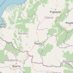
Map view of Santuario Orito Indí-Andé Fauna and Flora Sanctuary

Use this park location map to pinpoint Santuario Orito Indí-Andé Fauna and Flora Sanctuary in Colombia, understand its exact geographic position, and read its mapped placement within the surrounding landscape more clearly.

Pigeon | © OpenStreetMap contributors
Park atlas

Trace connected conservation landscapes across the Andean-Amazon transition and southern Colombia.

Explore Nearby Protected Areas and National Parks from Santuario Orito Indí-Andé Fauna and Flora Sanctuary

After exploring Santuario Orito Indí-Andé Fauna and Flora Sanctuary, continue your discovery of other national parks and protected areas across its surrounding Andean-Amazonian region. Compare varied conservation landscapes, trace the geographic distribution of protected areas, and map how diverse ecosystems connect within southern Colombia's complex terrain.
Watercolor painting of a lake with green hills and trees in the background
Protected areaNariño
About 46 km away#1 closest

Northwest

La Corota Island Flora Sanctuary: A Unique Protected Area within Colombia's Nariño Region

Explore its Andean cloud forest landscape and mapped island geography.

La Corota Island Flora Sanctuary is a critical protected area in Nariño, Colombia, celebrated for its distinctive status as the country's only lake island ecosystem supporting old-growth Andean cloud forest. This compact sanctuary provides a unique landscape context, safeguarding endemic plant species and diverse birdlife within its mapped boundaries. Its presence within Laguna de la Cocha highlights a special convergence of wetland and forest geography, offering insights for atlas exploration of protected lands.

Area
0.152 km²
Established
1977
IUCN
II
Visitors
28K annual
National parkColombia
About 60 km away#2 closest

Northeast

Serranía de Los Churumbelos Auka-Wasi National Natural Park: Colombia's Protected Landscape Atlas

Mapped national park boundaries and regional geography.

Understand Serranía de Los Churumbelos Auka-Wasi National Natural Park through its geographic context and protected landscape features. This atlas view highlights the park's mapped boundaries and its significance within Colombia's natural geography, offering detailed insights into its protected status and regional terrain.

Area
562 km²
Established
2007
IUCN
II
Relief
Mountain
Nature reserveSucumbíos
About 61 km away#3 closest

Southwest

Reserva Ecológica Cofán-Bermejo: Mapping Amazonian and Andean Biodiversity Landscapes

Indigenous-led conservation in the Sucumbíos river headwaters.

Reserva Ecológica Cofán-Bermejo encompasses a remarkable altitudinal range from 400 to 2,200 meters, protecting intact river basins and transitional ecosystems. This nature reserve offers deep insight into the convergence of Amazonian and Andean flora, functioning as a vital refuge for threatened megafauna and rare bird populations within an indigenous-managed territory.

Area
549.47 km²
Established
2002
IUCN
Ia
Relief
Mountain
Watercolor illustration of a mountain range with a lake in the foreground, green fields, and a colorful sky
Protected areaColombia
About 70 km away#4 closest

Northwest

Galeras Protected Area: Exploring Colombia's Mapped Natural Landscapes

Discover the geography and protected terrain of Galeras.

The Galeras protected area in Colombia offers a distinct opportunity for geographic exploration, focusing on its defined boundaries and the natural landscape it encompasses. This resource details the park's setting within the Colombian geography, providing a map-centric view of its protected status. Understanding Galeras contributes to a broader appreciation of protected lands across South America and their unique terrain.

Relief
Mountain
Climate
Alpine
Access
Highly restricted
National parkNariño Department
About 70 km away#5 closest

North

Doña Juana-Cascabel Volcanic Complex National Natural Park: National Park with Mapped Protected Landscape

Explore its volcanic terrain and geographic context in Nariño Department.

Doña Juana-Cascabel Volcanic Complex National Natural Park is a designated National Park offering rich opportunities for geographic exploration. Situated within Nariño Department, this protected landscape provides a unique lens through which to study regional natural features and mapped conservation boundaries. Its presence within Colombia's protected areas network makes it a key point of reference for understanding national park geography and landscape context.

Area
0.267 km²
Established
2007
IUCN
II
Relief
Mountain
Wildlife reserveSucumbíos
About 87 km away#6 closest

Southeast

Reserva de Producción de Fauna Cuyabeno: Geography of an Amazonian Wildlife Reserve

Explore protected boundaries and flooded landscape patterns in Sucumbíos

Reserva de Producción de Fauna Cuyabeno serves as a benchmark for Amazonian conservation, characterized by its extraordinary hydrological dynamics. The landscape comprises a network of blackwater rivers and semi-permanent lagoons that sustain an immense variety of species. As a protected area within Sucumbíos, it showcases the intricate relationship between seasonally submerged forests, terra firme terrain, and the vital river arteries that define this region.

Area
5,901.12 km²
Established
1979
IUCN
VI
Visitors
12K annual
National parkEcuador
About 108 km away#7 closest

Southwest

Sumaco Napo-Galeras National Park: Ecuador's Volcanic National Park Landscape

Explore protected areas and biodiversity in the Andean-Amazon transition.

Sumaco Napo-Galeras National Park protects a dramatic volcanic landscape in Ecuador, showcasing a significant elevation gradient that supports diverse cloud forest and Amazonian rainforest habitats. This national park is recognized for its endemic species and rich avifauna, offering a compelling case study for understanding protected land geography and ecological transitions within South America.

Area
2,067.49 km²
Established
1994
IUCN
II
Relief
Mountain
Nature reserveCarchi Province
About 111 km away#8 closest

West

Reserva ecológica El Ángel: High-Andean Protected Landscape and Geography Map

Exploring páramo ecosystems in Carchi Province, Ecuador

Reserva ecológica El Ángel is a crucial conservation area in the northern Andes, defined by its high-altitude páramo, volcanic geology, and extensive wetland network. It serves as a vital hydrological heart for Carchi Province, supporting diverse highland vegetation including dense stands of giant frailejón and ancient Polylepis forests across a dramatic, glacially-sculpted terrain.

Area
165.41 km²
Established
1992
IUCN
Ia
Relief
Mountain

Common questions about visiting, size, designation, and location context for Santuario Orito Indí-Andé Fauna and Flora Sanctuary

Santuario Orito Indí-Andé Fauna and Flora Sanctuary FAQs for park facts, access, geography, and protected area context

Find quick answers about Santuario Orito Indí-Andé Fauna and Flora Sanctuary, including protected-area facts, park geography, trail and visitor context, and how the park fits into its surrounding country and regional landscape.
MoriAtlas Explorer

Continue Your Protected Areas Search Across the Global Atlas

Deepen your exploration by continuing the structured search for national parks and protected areas worldwide. Utilize the comprehensive filtering capabilities to compare different conservation landscapes and refine your understanding of global park geography. Discover more about the distribution and characteristics of protected natural areas.

Global natural geography