
Mori Atlas logo
Protected areaSmør- og Fedtmosen

A regional watershed saddle connecting diverse wetland habitats and meadowland terrain near Copenhagen

Smør- og Fedtmosen Protected Area: Glacial Tunnel Valley Geography and Hydrological Mapping

Smør- og Fedtmosen represents a vital spring-fed mire system formed within a glacial tunnel valley in Denmark. Spanning 150 hectares between Herlev and Gladsaxe, the site acts as a critical hydrological hub that feeds both Værebro Å and Kagsåen. This mosaic of wet reed beds, fen-meadows, and higher ground reveals the complex natural legacy of a dead-ice landscape situated against the backdrop of modern urban development.

wetlandmirebogfenmeadowtunnel valley
A flat-style vector illustration depicting a lake or wetland in the foreground with reeds, surrounded by green trees, with a large waterfall cascading down pink mountain cliffs in the background.

Smør- og Fedtmosen

Protected area

Park overview

Structured park overview, official facts, and landscape profile for Smør- og Fedtmosen

Smør- og Fedtmosen park facts, protected area profile, and essential visitor context

Review the core facts for Smør- og Fedtmosen, including designation, size, terrain, visitor scale, habitats, and operating context in one park-focused overview.

About Smør- og Fedtmosen

Smør- og Fedtmosen is one of the more unusual protected natural areas in the Danish Capital Region because it sits almost entirely within the urbanized suburban belt north of Copenhagen. Despite this proximity to dense residential development, motorways, and municipal infrastructure, the site preserves around 150 hectares of wetland, mire, scrub, and meadow that together form a coherent ecological and hydrological unit.

The landscape is structured around a broad, shallow tunnel valley cut into the glacial deposits of North Zealand. Within that valley, the uneven melting of the last ice sheet left dead-ice depressions that became spring mires, with groundwater rising through the low-lying ground to form the wet core of the reserve today. The four sub-areas each reflect a slightly different expression of that underlying landscape: Smørmosen in the east is the wettest and most peat-influenced, containing the largest lake, Tårnsø, and the source reaches of Værebro Å. Fedtmosen, just to the west, is somewhat drier and reads more as an open fen-meadow landscape with scattered scrub, fed historically by the same groundwater system but draining more rapidly through the adjoining stream corridor.

Feddet, by contrast, sits a little higher on the valley floor and is dominated by meadowland with scattered farm buildings, including Rævebakke, the highest point in the reserve at 29 meters above sea level. South of the main mires, the more recently protected Hjortespring mark adds former agricultural ground, old farmsteads, and a small botanical park known as Træbanken that displays many of Denmark's common trees and shrubs. Together these four pieces create a managed transition from mire through meadow to cultivation, all held within a single continuous protection framework.

Beyond its ecological value, the reserve is notable for the way it has retained traces of long-term human use. Archaeological finds in and around the mires include Stone Age settlement evidence and a dugout canoe now held at the National Museum, alongside Iron Age artifacts such as oars, ceramics, and bones. This layered cultural record, combined with the site's central role in the regional water system, makes Smør- og Fedtmosen a landscape where glacial geology, wetland ecology, and centuries of human presence are all visible on the same piece of ground.

Quick facts and research context for Smør- og Fedtmosen

Smør- og Fedtmosen is a protected Danish mire and meadow complex of around 150 hectares, divided across Herlev and Gladsaxe municipalities north of Copenhagen. It was established as a protected site in 1943 and expanded in 2003 to 2004, making it one of the larger contiguous urban-fringe wetland reserves in the Capital Region.

The area is a source landscape for two major streams, Værebro Å and Kagsåen, placing it on a divide between the Roskilde Fjord and Køge Bugt catchments. Its terrain reflects a classic North Zealand tunnel valley and dead-ice landscape, with kettle-like depressions that fill with groundwater to form the mires, reed beds, and small lakes that the reserve is built around.

Protection and recognition

Documented terrestrial protection scope and established designation timeline

Smør- og Fedtmosen Protection Status and Designated History

Smør- og Fedtmosen preserves a documented terrestrial protection status established in 1943. Historical designation records outline the management scope and conservation standing associated with the protected landscape.

Protection details

Protection scope
Terrestrial
Designated year
1943
Park context

Deeper park guide and search-rich context for Smør- og Fedtmosen

Smør- og Fedtmosen history, landscape, wildlife, and travel context

Explore Smør- og Fedtmosen through its history, landscape character, ecosystems, wildlife, conservation priorities, cultural context, and seasonal travel timing in a structured park guide built for atlas discovery and search intent.

Why Smør- og Fedtmosen stands out

Smør- og Fedtmosen is best known as a spring-fed mire system occupying the floor of a glacial tunnel valley, where groundwater emerges from dead-ice depressions to feed two major streams. Its hydrological role as a watershed "saddle" between the Roskilde Fjord and Køge Bugt basins gives the site a significance that reaches well beyond its modest size. The reserve is also known for its mosaic of wet and dry habitats, including reed beds dominated by Phragmites, willow and alder scrub, birch and hawthorn thickets, and traditionally grazed meadows managed with hardy Galloway cattle. Together these elements preserve a working example of how a former peat-mire landscape has been shaped by centuries of small-scale human use while retaining its wetland character.
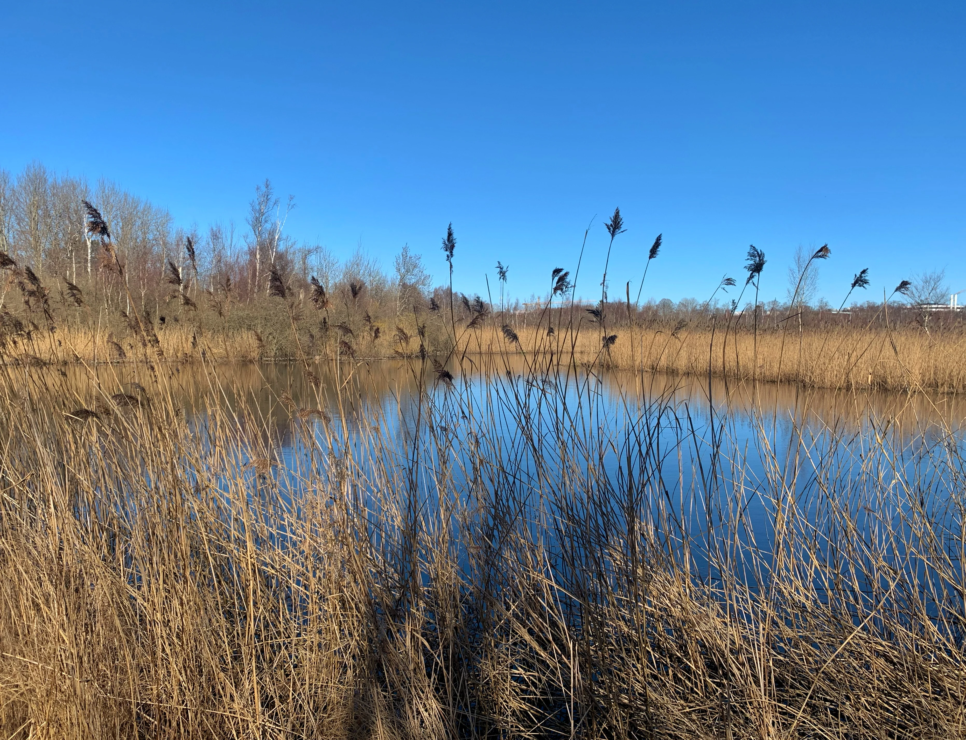
A calm, still pond surrounded by tall, dry reeds and grasses under a clear blue sky, characteristic of a wetland environment.
A view of the Smørmosen moorland area featuring marshy vegetation and a calm pond.

Smør- og Fedtmosen history and protected-area timeline

The history of Smør- og Fedtmosen as a worked and inhabited landscape stretches back to prehistoric times. Archaeological surveys in Smørmosen have uncovered evidence of an Early Neolithic settlement, and a dugout canoe recovered from the mire today sits in the National Museum's collections. Iron Age finds from the same area, including oars, ceramic vessels, and animal bones, suggest that the wetlands continued to be used and traversed throughout later prehistory. The slightly higher ground of Feddet is considered likely to hold further archaeological potential, having stood above the water table since the Stone Age.

During the mid-eighteenth century, the mires were reorganized through the Danish enclosure reforms, known as udskiftningen. The wetland was divided into a patchwork of small individual lots, each assigned to local landowners. These parcels were subsequently used for hunting, livestock grazing, and cutting of peat for fuel. The pattern of ditching and small pools left by that process still shapes the micro-topography of the reserve today. Because the enclosure happened gradually rather than all at once, the most recently apportioned plots retained more standing water, and they remain the wettest parts of the mire.

Industrial-scale peat extraction continued in the area until the mid-twentieth century. Many of the ponds and small lakes that now break up the mire surface originated as water-filled former diggings, a direct legacy of that turf-cutting era. In 1943, the Danish nature protection authorities placed the core of the area, including the main bodies of Smørmosen, Fedtmosen, and Feddet, under formal protection, an early example of urban-fringe conservation in the Capital Region.

The final expansion of the reserve came in 2003 to 2004, when the Hjortespring mark south of the main mires was brought under the same protection regime. This addition included former farmland associated with two historical farmsteads, Kildegården and Klavsdal, as well as the Træbanken, a former municipal tree nursery that had supplied trees for Copenhagen's streets, parks, and institutions until 1992 and is now managed as a small botanical park.

Smør- og Fedtmosen landscape and geographic character

The terrain of Smør- og Fedtmosen is the surface expression of a classic glacial tunnel valley, a broad, U-shaped lowland carved by meltwater beneath the retreating ice sheet at the close of the last Ice Age. Within this valley, a so-called dead-ice landscape formed where isolated blocks of slow-melting ice left irregular depressions; these low points later filled with groundwater to become the spring mires that anchor the reserve.

The valley floor is gently graded, with subtle but important elevation differences between its sub-areas. Smørmosen in the east is the lowest, most waterlogged section, drained by small channels feeding the headwaters of Værebro Å and including the reserve's principal lake, Tårnsø. Fedtmosen to the west reads as a slightly higher, better-drained fen-meadow landscape, still underlain by peat but with a more open, less saturated surface. Between them rises Feddet, whose gently elevated ground hosts the reserve's high point, Rævebakke, at 29 meters above sea level, along with scattered farms and patches of meadow.

South of the mires, the Hjortespring mark forms a smoother, more cultivated-feeling terrain of former fields and farmsteads, including the gentle slopes around the small parks and lanes associated with the Klauzdal activity center and the Træbanken. To the east, the Hillerødmotorvejen motorway provides a hard modern edge to the otherwise soft, lowland character of the reserve.

Smør- og Fedtmosen ecosystems, habitats, and plant life

The natural character of Smør- og Fedtmosen is fundamentally defined by its hydrology. Cold, clean groundwater rises through the permeable glacial deposits of the tunnel valley and emerges along the valley floor, creating the spring mires, saturated peatlands, and shallow lakes that dominate the eastern half of the reserve. This pattern of groundwater-driven habitat is the reason the area retains a wetland character in such a heavily urbanized region.

Smørmosen, the wettest core of the reserve, is dominated by extensive reed beds of Phragmites, interrupted by willow and alder scrub and patches of true mire vegetation. The largest open water here is Tårnsø, the lake that marks the rise of Værebro Å, and the area as a whole is described as having very limited practical accessibility, with the soft, waterlogged ground making most of the interior hard to traverse on foot. A bird-watching tower in the southern, wettest part of Smørmosen is positioned specifically to take advantage of this combination of open water, reed edge, and surrounding scrub.

Fedtmosen presents a leaner version of the same system. The reed beds are reduced, true mire is rarer, and open fen-meadow takes over, punctuated by stands of willow, birch, and hawthorn scrub. Because the surface here is firmer, the area supports low-intensity grazing by Galloway cattle, a hardy breed used widely for nature management in Denmark, which helps maintain the open character of the meadow.

Feddet and Hjortespring mark extend the habitat palette from mire and meadow into dry-ground woodland edge and formerly cultivated parkland. Feddet carries scattered hawthorn scrub and grassland, while the Hjortespring area adds ruderal vegetation, old orchard and field remnants, and the arboretum-like plantings of the Træbanken, where many common Danish trees and shrubs are represented together in one place. The composite effect, across all four sub-areas, is a fine-grained mosaic of wet, dry, open, and lightly wooded habitats compressed into a very small area.

Smør- og Fedtmosen wildlife and species highlights

Direct information about specific species in the source material is limited, and the reserve is described more through its habitat structure than through its animal inhabitants. What can be said with confidence is that the mosaic of open water, reed beds, scrub, and fen-meadow in Smør- og Fedtmosen provides habitat for the wetland bird communities and small-scale aquatic life typical of Danish spring mire systems, and the presence of a dedicated bird-watching tower in the wettest part of Smørmosen reflects recognized bird interest in the area.

Galloway cattle are the most visible large animals on the site, used as a management tool in Fedtmosen to keep meadow vegetation open through grazing rather than as a feature of the native fauna. The reserve's surrounding habitats of scrub and meadow also support the usual range of small mammals and breeding birds associated with lowland Danish wetland edges, though the source does not enumerate these in detail.

Smør- og Fedtmosen conservation status and protection priorities

Smør- og Fedtmosen has conservation significance that goes well beyond a typical urban-fringe nature reserve. The site sits on the hydrological divide between two major catchments, those of Roskilde Fjord via Værebro Å and of Køge Bugt via Kagsåen, and it acts as the spring zone for both streams. Protecting this headwater landscape therefore safeguards downstream water quality, flow regime, and habitat continuity in two separate drainage basins, a function that gives the reserve a regional importance disproportionate to its size.

The site's formal protection has also been progressive and well documented. The first protected designations were applied in 1943, an unusually early date for urban-edge Danish conservation, and protected the mires of Smørmosen, Fedtmosen, and the elevated ground of Feddet. A further protection order in 2003 to 2004 extended that framework to the Hjortespring mark, bringing the formerly cultivated southern ground under the same regime and adding farmland, farmsteads, and the Træbanken arboretum as protected landscape elements.

Habitat management is an active part of the reserve's conservation work. Grazing by Galloway cattle maintains the open fen-meadow structure of Fedtmosen, while the watery core of Smørmosen is preserved primarily through its inaccessibility and the protection of the water regime that keeps its peat surfaces saturated. The Træbanken, meanwhile, serves a complementary role by keeping examples of common Danish woody species in active cultivation, supporting public awareness of native flora even where the surrounding landscape is urban.

Smør- og Fedtmosen cultural meaning and human context

The cultural record at Smør- og Fedtmosen is unusually layered for a small wetland reserve. Prehistoric remains from Smørmosen include evidence of an Early Neolithic dwelling site and a dugout canoe, now held at the National Museum, alongside Iron Age artifacts such as paddles, ceramic vessels, and animal bones. Together these finds suggest a long-running human relationship with the wetlands, both as a source of fish and waterfowl and as a route of movement across the otherwise thickly settled North Zealand landscape. Feddet, sitting slightly above the water table, is regarded as having archaeological potential as well, since it has been dry ground since the Stone Age.

In more recent centuries, the area carries visible traces of the Danish enclosure reforms of the mid-eighteenth century, when the mires were subdivided into small individual lots that were then used for grazing, hunting, and peat extraction. The maze-like pattern of small ditches, ponds, and hummocks that defines much of the mire surface today is in part a direct artifact of that redistribution. Peat cutting continued at a working scale through to the mid-twentieth century, and many of the present-day ponds in the reserve are former diggings that simply filled with water once turf removal ceased.

The Hjortespring mark section adds another, more domestic layer of cultural landscape. Old farmsteads such as Kildegården and Klavsdal, the latter now used as a municipal activity property, preserve something of the area's agricultural past, while the Træbanken, formerly a Copenhagen municipal tree nursery, preserves a more technical cultural artifact: a working collection of the trees and shrubs used to green the city's streets, parks, and institutions.

Top sights and standout views in Smør- og Fedtmosen

The reserve functions as a regional hydrological hub, feeding both Værebro Å toward Roskilde Fjord and Kagsåen toward Køge Bugt from a single piece of spring-fed glacial valley floor.

Within a small footprint, it preserves a full gradient of habitats, from the deep reed beds and open water of Smørmosen, through the grazed fen-meadow of Fedtmosen, to the higher meadowland of Feddet and the formerly cultivated ground of Hjortespring mark.

Long-running protection, from 1943 to the 2003 expansion, has allowed relict mire vegetation and nineteenth- and twentieth-century land use patterns to coexist within an actively managed urban-fringe reserve.

Best time to visit Smør- og Fedtmosen

Because the source material does not address seasonal access conditions or visitor logistics in any operational sense, only very broad seasonal framing can be supported here. As a wetland and meadow landscape in the temperate Danish climate, Smør- og Fedtmosen will read very differently between seasons: spring and early summer tend to bring the highest water levels, the most active growth of reed beds and meadow vegetation, and the most active bird song around the lakes and wet scrub. Late summer and autumn are typically when open fen-meadow flowers and seed heads are most visible and when the bird-watching tower in the wetter parts of Smørmosen is most often used.

Winter visits tend to emphasize the openness of the landscape, with the reed beds and meadows taking on a quieter, more skeletal character, though winter weather and the soft ground in the wettest sections can make some of the interior trails impractical. Because the area receives visitors from surrounding suburbs, the mildest, driest conditions generally offer the most comfortable experience for casual walking across the full mosaic of sub-areas.

Monthly climate preview

Long-term representative temperature and monthly precipitation averages for Smør- og Fedtmosen

Smør- og Fedtmosen Climate Normals and Measured Weather by Month

Historical NASA POWER records from 1991 to 2020 outline the measured temperature progression and monthly precipitation rhythm across the representative coordinate for Smør- og Fedtmosen. Detailed twelve-month climatology data provides deeper context for examining long-term average temperature ranges and precipitation totals throughout the year.
Annual mean9 °C
1 °C18 °C
Jan
Feb
Mar
Apr
May11°
Jun15°
Jul18°
Aug17°
Sep14°
Oct
Nov
Dec
Warmest month
July

17.5 °C

Coolest month
February

0.6 °C

Wettest month
August

2.6 mm/day

Driest month
April

1.4 mm/day

Park location guide

Geography guide, regional context, and park location map for Smør- og Fedtmosen

Smør- og Fedtmosen park geography, regions, and map view in Denmark

Understand where Smør- og Fedtmosen sits in Denmark through a broader geographic reading of the surrounding landscape, nearby location context, and its mapped position within the national park landscape.

How Smør- og Fedtmosen fits into Denmark

Denmark is a constitutional monarchy and Nordic country in Northern Europe. It is the southernmost of the Scandinavian countries, bordering Germany to the south, Norway to the north, and Sweden to the southwest. The country consists of the Jutland peninsula and an archipelago of islands, with Copenhagen as its capital and largest city. Denmark has a population of over 6 million and is characterized by flat, arable land, sandy coasts, and a temperate climate.

Wider geography shaping Smør- og Fedtmosen in Denmark

Denmark occupies the Jutland peninsula and roughly 406 islands in Northern Europe. It is situated between the North Sea to the west and the Baltic Sea to the east. The country borders Germany to the south and is connected to Sweden via the Øresund Bridge. Denmark is predominantly flat terrain with low elevation, the highest point being Møllehøj at 170.86 meters.

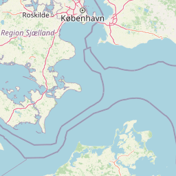
Map view of Smør- og Fedtmosen

Use this park location map to pinpoint Smør- og Fedtmosen in Denmark, understand its exact geographic position, and read its mapped placement within the surrounding landscape more clearly.

Pigeon | © OpenStreetMap contributors

Visual reference collection highlighting glacial tunnel valley terrain and mire habitats

Smør- og Fedtmosen Landscape Photos and Protected Wetland Scenery

Visual records capture the spring-fed mire systems and varied meadow terrain defining the protected character of Smør- og Fedtmosen. Photographic documentation reveals the underlying glacial tunnel valley structure, reed beds, and ecological gradients across the reserve.

A calm, still pond surrounded by tall, dry reeds and grasses under a clear blue sky, characteristic of a wetland environment.

A slightly elevated view looking over a grassy, wetland meadow in Smør- og Fedtmosen, with trees scattered throughout and an overcast sky.

Park atlas

Compare surrounding regional reserves and connected wetland landscapes.

Parks Near Smør- og Fedtmosen and Related Protected Areas to Explore

Visitors exploring Smør- og Fedtmosen can browse neighboring protected areas and wetland reserves across the surrounding region. Comparing adjacent natural habitats provides broader context into regional geography and local watershed patterns.
A watercolor illustration of a serene lakeside landscape with green hills, foliage, and calm water, painted in soft pastel colors.
Protected areaNorth Zealand
About 5.6 km away#1 closest

North

Furesø Protected Area: Mapping the Deepest Glacial Lake and Wetland Systems of North Zealand

Glacial tunnel valley landscapes and Natura 2000 protected waters.

Spanning deep basins and shallow shorelines, Furesø represents a significant protected freshwater body within the North Zealand region. The surrounding mosaic of peatlands and alder swamps highlights a legacy of glacial activity and ongoing conservation efforts. This area remains a focal point for understanding the interplay between metropolitan geography and preserved natural terrain.

Area
9.41 km²
Relief
Lowland
Climate
Temperate
Access
Easy access
Nature reserveGentofte Kommune
About 5.7 km away#2 closest

East

Brobæk Mose Nature Reserve: Protected Wetland and Glacial Geography in Gentofte Kommune

Mapped wetland habitat and natural terrain analysis.

Brobæk Mose serves as a primary example of a spring-fed wetland within the glacial landscapes of Gentofte Kommune. The area preserves rich fens and developing natural forest, offering a clear view of post-glacial valley geography and protected ecological zones surrounded by the Copenhagen suburban environment.

Established
1988
Water
Major water bodies
A horizontal watercolor painting depicting a soft, light-filled meadow landscape with scattered trees, low vegetation, and patches of water.
Nature reserveCopenhagen
About 14 km away#3 closest

Southeast

Amager Fælled Nature Reserve: Mapping Copenhagen's Distinctive Protected Landscape

Explore pioneer plant habitats and coastal meadow geography

Amager Fælled functions as a 223-hectare nature reserve that borders the urban development of Copenhagen. The landscape offers a study in contrasts, featuring thin drought-prone soils, historical military and landfill substrates, and protected coastal meadow strips. This site remains a vital geographical reference for understanding urban-edge conservation and the long-term layering of human land use.

Area
2.23 km²
Established
1992
Relief
Lowland
Climate
Temperate
A watercolor illustration of a soft rolling landscape with green forests, gentle hills in shades of yellow and pink, and a winding waterway.
Protected landscapeDenmark
About 15 km away#4 closest

Northwest

Naturpark Mølleåen: A Protected Glacial Landscape and Tunnel Valley Map in Denmark

Glacial landforms and conserved nature corridors near Copenhagen

Naturpark Mølleåen spans fifty square kilometers of protected forests, lake districts, and ice-margin ridges in northern Zealand. This glacial terrain represents a nationally recognized geological area, offering a rare density of tunnel valleys and meltwater channels that serve as an essential ecological refuge within the broader Danish landscape.

Area
50 km²
Established
1942
Relief
Upland
Climate
Temperate
Nature reserveSolrød Kommune
About 30 km away#5 closest

Southwest

Staunings Ø Nature Reserve: Exploring the Coastal Geomorphology of Solrød Kommune

A mapped barrier spit and wetland habitat on the eastern Zealand shoreline.

Staunings Ø functions as a textbook example of a coastal sand bar accretion in the shallow waters of Køge Bugt. This nature reserve protects a vital sequence of dunes, lagoons, and reedbeds that provide a clear view of coastal succession. Located near the urban edge of Solrød Kommune, it serves as a key site for understanding the interaction between natural coastal landforms and maritime environments in eastern Denmark.

Area
0.6 km²
Established
1999
Relief
Lowland
Climate
Temperate
Watercolor illustration of green hills, a body of water, and vegetation
National parkDenmark
About 32 km away#6 closest

Northwest

Kongernes Nordsjælland National Park: Protected Landscape Geography and Map Context

Explore North Zealand's protected natural terrain.

Delve into the protected landscape of Kongernes Nordsjælland National Park, a significant national park in Denmark's North Zealand region. This section provides a structured overview of its mapped boundaries and geographic setting, allowing for a detailed atlas-style discovery of its natural terrain. Understand how this protected area contributes to the region's conservation landscape and mapped geography.

IUCN
II
Nature reserveFaxe Municipality
About 49 km away#7 closest

Southwest

Bagholt Mose: Protected Peatland Mosaic and Fen Geography in Faxe Municipality, Denmark

A high-value Natura 2000 protected wetland and bog habitat.

Bagholt Mose is a significant nature reserve situated within the Munkeskov forest of southern Zealand. The landscape features a distinct combination of historical peat cuttings and raised bog remnants, which together form a rare mosaic of nutrient-poor and calcareous fen communities that support an exceptional diversity of lowland bog flora.

Area
0.17 km²
Established
1985
Relief
Lowland
Scope
Terrestrial
National parkSweden
About 55 km away#8 closest

Northeast

Söderåsen National Park: A Protected Ridge Landscape in Southern Sweden's Geography

Mapped protected area with varied terrain and dense forest cover.

Delve into the protected landscape of Söderåsen National Park, a national park in Southern Sweden distinguished by its unique ridge topography, steep slopes, and extensive forests. This site serves as a key point for atlas-based exploration of natural terrain and regional geography, offering a clear view of its mapped boundaries and ecological significance within the Southern Swedish highlands. Understand the character of this protected area and its place in the broader mapped landscape.

Established
2001
IUCN
II
Scope
Terrestrial

Common questions about visiting, size, designation, and location context for Smør- og Fedtmosen

Smør- og Fedtmosen FAQs for park facts, access, geography, and protected area context

Find quick answers about Smør- og Fedtmosen, including protected-area facts, park geography, trail and visitor context, and how the park fits into its surrounding country and regional landscape.
MoriAtlas Explorer

Continue Your Protected Areas Search Across the Global Atlas

Deepen your exploration by continuing the structured search for national parks and protected areas worldwide. Utilize the comprehensive filtering capabilities to compare different conservation landscapes and refine your understanding of global park geography. Discover more about the distribution and characteristics of protected natural areas.

Global natural geography