
Mori Atlas logo
Nature reserveStawy Kiszkowskie

Mapping the aquatic mosaic and xerothermic grasslands of the Gnieźnieńskie Lakeland

Stawy Kiszkowskie Nature Reserve and the Mała Wełna River Valley Protected Landscape

(Stawy Kiszkowskie (PLH300050))

Stawy Kiszkowskie represents a vital Natura 2000 special area of conservation situated within the Gnieźnieńskie Lakeland of the Greater Poland Voivodeship. This protected landscape encompasses a distinct river valley system characterized by man-made fishponds, reedbeds, and willow thickets. The site serves as a crucial staging point for migratory waterbirds within the west-central Polish plains, offering a unique example of how managed aquatic environments support regional ecological integrity.

Natura 2000fishpondswetlandsbirdwatchingcranesgeese
A digital illustration of a calm wetland scene with a dirt path winding between a grassy canal and a larger pond, under a soft pastel sky.

Stawy Kiszkowskie

Nature reserve

Park overview

Structured park overview, official facts, and landscape profile for Stawy Kiszkowskie

Stawy Kiszkowskie park facts, protected area profile, and essential visitor context

Review the core facts for Stawy Kiszkowskie, including designation, size, terrain, visitor scale, habitats, and operating context in one park-focused overview.

About Stawy Kiszkowskie

Stawy Kiszkowskie is a protected wetland complex in the Wielkopolskie region of west-central Poland, falling within the broader Gnieźnieńskie Lakeland landscape zone. Although modest in size and lacking the wild, primeval character of large national parks, it occupies an important ecological niche as a managed fishpond valley that has matured into a habitat of considerable value for birds, aquatic plants, and wetland-dependent wildlife.

The site is built around two groups of artificial ponds. The larger complex covers approximately 200 hectares, while the second consists of a chain of smaller ponds, ranging from about half a hectare to roughly fifteen hectares each, strung along a small watercourse between the villages of Rybno Wielkie and Pomarzany. These ponds were originally brought into use in the 1980s for extensive carp aquaculture. The surrounding small lakes Rybno Północne and Rybno Południowe complement the wetland network.

A defining feature of the area is its hydrological instability. Water levels fluctuate by several dozen centimeters from year to year, and in some dry seasons the ponds may even fall completely dry. Rather than undermining the site's value, this variability has helped shape a richly structured mosaic of open water, shallow overgrown margins, reedbeds, willow scrub, and seasonally exposed sediments, all of which support a rich and variable bird community across the annual cycle.

The wider setting is open agricultural countryside without large woodland blocks, which makes the wetlands stand out as the dominant ecological feature of the landscape. The embankments separating the ponds are covered with grassy vegetation that often shows xerothermic characteristics, an unusual contrast to the otherwise moist, water-dominated environment that defines the site.

Quick facts and research context for Stawy Kiszkowskie

Stawy Kiszkowskie is a Polish Natura 2000 habitat Special Area of Conservation identified by the code PLH300050. It lies in the Gmina Kiszkowo within the Gniezno Powiat of the Wielkopolskie Voivodeship, and falls within the mesoregion known as the Pojezierze Gnieźnieńskie, or Gnieźnieńskie Lakeland.

The site was proposed by the European Commission on 8 February 2011 and formally designated by Polish authorities on 18 February 2022. Its total area is 477.49 hectares, built around two complexes of fishponds that together span roughly 200 hectares of open water, reedbed, and seasonally flooded habitat along a section of the Mała Wełna river valley.

Protection and recognition

Documented conservation history, designation year, and Natura 2000 records

Stawy Kiszkowskie Protection Status and International Recognition Data

Stawy Kiszkowskie maintains documented protected area designation established in the year 2022 alongside official Natura 2000 recognition sources. Conservation tracking outlines the administrative history and international status associated with this protected landscape.
Park context

Deeper park guide and search-rich context for Stawy Kiszkowskie

Stawy Kiszkowskie history, landscape, wildlife, and travel context

Explore Stawy Kiszkowskie through its history, landscape character, ecosystems, wildlife, conservation priorities, cultural context, and seasonal travel timing in a structured park guide built for atlas discovery and search intent.

Why Stawy Kiszkowskie stands out

Stawy Kiszkowskie is best known as a major autumn staging area for common cranes, which gather in flocks of roughly 700 to 1,400 birds on the largest central pond before continuing their migration. The site is equally valued for the sheer volume of geese that congregate there during autumn passage, including mixed flocks of bean geese and white-fronted geese that have been counted in the tens of thousands. Beyond its birdlife, the area is recognizable for its unusual hybrid character: a working fishpond landscape, much of it shallow and overgrown, embedded in a low-intensity agricultural valley with xerothermic dike grasslands. It is a quintessential example of how semi-natural, human-shaped wetland systems can become critical refuges for migratory waterbirds across the European plains.
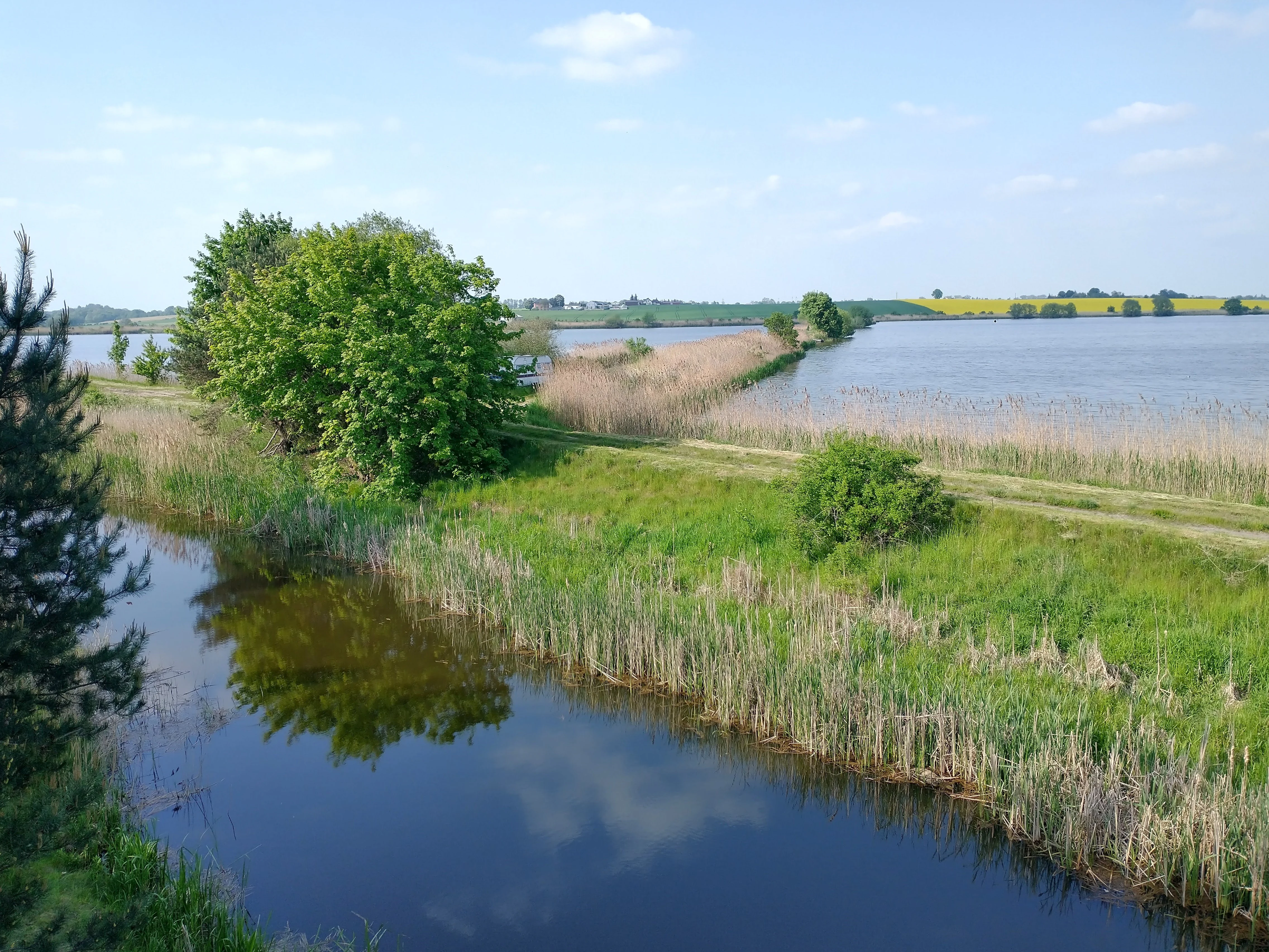
A wide shot of calm, dark water in a pond bordered by green grass, reeds, and leafy trees, with a distant treeline and blue sky in the background.
A scenic view of the wetland habitats and fish ponds at the Stawy Kiszkowskie nature reserve.

Stawy Kiszkowskie history and protected-area timeline

The fishponds at Stawy Kiszkowskie were constructed and put into operation during the 1980s as part of the extensive inland aquaculture typical of the Polish lowlands, with carp farming as the principal economic activity. Their maintenance has long been complicated by significant fluctuations in water levels, a problem that gradually shifted the character of parts of the complex away from purely productive waterbodies and toward overgrown, ecologically richer wetland habitat.

Recognition of the site's conservation importance came through the Natura 2000 process. The European Commission proposed the area as a Special Area of Conservation on 8 February 2011, and Polish authorities formally designated it on 18 February 2022, anchoring the future of the ponds within the European Union's protected-area framework.

Stawy Kiszkowskie landscape and geographic character

The landscape of Stawy Kiszkowskie is shaped by a gentle glacial river valley, the Mała Wełna, set within the rolling terrain of the Gnieźnieńskie Lakeland. Rather than dramatic relief, the scene is defined by flat or gently undulating agricultural land interrupted by two clear clusters of open water and wetland.

The larger pond complex reads as a broad, shallow expanse of water threaded with reedbeds, willow thickets, and seasonally flooded flats. The smaller complex forms a linear chain of basins strung along a modest stream between Rybno Wielkie and Pomarzany, with the smallest ponds sometimes entirely overgrown and the larger ones still holding open water. Grass-covered dikes crisscross the system, their turf often carrying a notably dry, warm-climate character unusual for a wetland setting.

Beyond the ponds, the surroundings consist of open farmland without significant woodland. Two natural lakes, Rybno Północne and Rybno Południowe, sit nearby and add further open-water character to the wider mosaic. The overall impression is of a lowland countryside whose ecological identity is concentrated almost entirely in its waters and wet margins rather than in forest cover or topography.

Stawy Kiszkowskie ecosystems, habitats, and plant life

Ecologically, Stawy Kiszkowskie is defined by its combination of artificial fishponds, natural river-valley wet habitats, and dry grassland patches on the embankments. Much of the pond area has shifted away from intensive production and now functions as semi-natural wetland, with extensive reedbeds, willow scrub, shallow flooded clearings, and periodically exposed muddy substrates.

Hydrological variability is a key driver of habitat diversity here. Fluctuating water levels continually reset successional stages along pond margins, creating a shifting patchwork of open water, emergent vegetation, and damp bare ground. The xerothermic dike grasslands add an unexpected element, supporting plant communities adapted to warmer and drier conditions in close proximity to the wetland core.

The wider area lacks large forest tracts, so habitat connectivity depends on the ponds themselves, the river corridor of the Mała Wełna, and the surrounding agricultural land. This combination gives the site a strong but localized ecological profile, heavily influenced by water regime and by the continuing, low-intensity management of the ponds.

Stawy Kiszkowskie wildlife and species highlights

The wildlife profile of Stawy Kiszkowskie is dominated by birds, particularly waterbirds and large migratory species that depend on the pond complexes as seasonal staging areas. Common cranes are a signature presence, regularly using the largest 60-hectare central pond as a pre-breeding night roost and gathering in autumn in flocks of roughly 700 to 1,400 individuals.

Autumn migration brings exceptional concentrations of geese. In 2003, mixed flocks of bean geese and white-fronted geese were counted here at 28,000 to 30,000 birds, illustrating the site's national and regional importance for these species. Greylag geese are also regular visitors, with a recorded peak of about 1,350 birds in 2013.

Diverse smaller waterfowl and shorebirds further enrich the site. Barnacle geese, pink-footed geese, common pochards, northern shovelers, Eurasian wigeons, Eurasian teals, northern lapwings, and ruff have all been recorded, taking advantage of the shallow water, mud margins, and variable water levels that expose feeding habitat throughout much of the year.

Stawy Kiszkowskie conservation status and protection priorities

As a Natura 2000 Special Area of Conservation under the European habitat directive, Stawy Kiszkowskie holds formal recognition for its habitat values at both the European and national levels. Its inclusion in the network reflects its role in conserving wetland and waterbird habitats that are scarce or under pressure across much of the European continent.

The site illustrates how working fishpond landscapes can serve conservation when paired with low-intensity management. Despite ongoing problems with water supply and highly variable water levels, the ponds provide habitat for species that depend on exactly this kind of unpredictable, dynamic aquatic environment. The challenge for conservation management lies in maintaining the mosaic of open water, reedbed, scrub, and exposed sediment that makes the site valuable, while sustaining the traditional extensive aquaculture that continues to shape it.

Stawy Kiszkowskie cultural meaning and human context

The cultural context of Stawy Kiszkowskie is rooted in the long-standing tradition of inland fish farming in the Polish lowlands. The ponds, brought into use in the 1980s, are part of a broader pattern of small and medium-sized fishpond complexes that have shaped rural land use across Wielkopolska for generations.

The surrounding parishes and villages, including Kiszkowo, Rybno Wielkie, and Pomarzany, are part of an agricultural landscape where fish culture, crop farming, and small-scale rural life have long coexisted. The protected status of the ponds does not displace this rural identity; instead, it overlays an inherited working landscape with a new layer of European ecological significance, blending local livelihood traditions with broader environmental recognition.

Top sights and standout views in Stawy Kiszkowskie

Stawy Kiszkowskie stands out as a key Polish waterbird site, especially during autumn migration, when the ponds attract tens of thousands of geese and large, easily observed flocks of common cranes.

Its combination of variable water levels, fishpond management, reedbeds, willow scrub, and unusually dry dike grasslands gives the site a distinctive ecological character even within the Natura 2000 network. For birdwatchers and ecologists, it is a compact but highly rewarding destination that captures many of the conservation values of central European lowland wetlands in a single, accessible landscape.

Best time to visit Stawy Kiszkowskie

The site is most rewarding to visit during the spring pre-breeding period and especially during the autumn migration window, when cranes gather on the central pond in their characteristic large roosting flocks and mixed flocks of geese arrive in significant numbers. These seasons offer the most reliable chance to encounter the area's signature species at peak abundance.

At other times of year, the ponds still retain interest, with waterfowl and local breeding birds using the reedbeds and open water, but the overall atmosphere of the place revolves around the dramatic seasonal influx of migratory waterbirds that defines its identity.

Monthly climate preview

Review long-term monthly temperature averages and precipitation rhythms for Stawy Kiszkowskie.

Stawy Kiszkowskie Climate Normals and Measured Annual Temperature Patterns

Representative coordinate records show the recorded monthly progression of average temperatures and precipitation for Stawy Kiszkowskie from 1991 to 2020. Examining the complete twelve-month climatology dataset reveals detailed shifts in regional weather patterns across the protected area.
Annual mean9 °C
-2 °C20 °C
Jan-2°
Feb-1°
Mar
Apr
May14°
Jun17°
Jul20°
Aug20°
Sep15°
Oct
Nov
Dec-1°
Warmest month
July

19.8 °C

Coolest month
January

-2.5 °C

Wettest month
July

2.5 mm/day

Driest month
April

1.1 mm/day

Park location guide

Geography guide, regional context, and park location map for Stawy Kiszkowskie

Stawy Kiszkowskie park geography, regions, and map view in Poland

Understand where Stawy Kiszkowskie sits in Poland through a broader geographic reading of the surrounding landscape, nearby location context, and its mapped position within the national park landscape.

How Stawy Kiszkowskie fits into Poland

Poland, officially the Republic of Poland, is a Central European country spanning from the Baltic Sea in the north to the Carpathian Mountains in the south. It borders Germany, Czech Republic, Slovakia, Ukraine, Belarus, Lithuania, and Kaliningrad Oblast. The country has a temperate climate, diverse landscapes, and is known for its rich history, cultural heritage, and strong economic position within the EU.

Wider geography shaping Stawy Kiszkowskie in Poland

Poland occupies 312,696 km2 in Central Europe, extending from the Baltic Sea coast in the north to the Sudetes and Carpathian Mountains in the south. It borders Germany to the west, Czech Republic and Slovakia to the south, Ukraine and Belarus to the east, and Lithuania and Kaliningrad Oblast to the northeast. The landscape includes lowland plains, uplands, and mountain ranges.

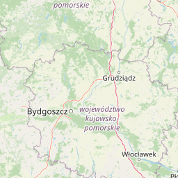
Map view of Stawy Kiszkowskie

Use this park location map to pinpoint Stawy Kiszkowskie in Poland, understand its exact geographic position, and read its mapped placement within the surrounding landscape more clearly.

Pigeon | © OpenStreetMap contributors

Location context for Stawy Kiszkowskie

Greater Poland Voivodeship
Recorded earthquake history

View Recorded Earthquake History and Seismic Archives for Stawy Kiszkowskie

Review the documented history of seismic events identified within the geography surrounding Stawy Kiszkowskie. This MoriAtlas collection aggregates available data on past epicentres, allowing for a structured comparison of historical activity within the Gnieźnieńskie Lakeland context.

Stawy Kiszkowskie Earthquake History

Catalogued events

2 events

Strongest magnitude

Magnitude 3

Most recent event

Aug 11, 1997

This history includes earthquakes recorded inside the park or within 50 km of its borders

Visual reference guide to wetland habitats, fishponds, and valley terrain

Stawy Kiszkowskie Photos and Landscape Scenery

Visual records capture the distinctive wetland habitats, shallow fishponds, and open agricultural terrain defining Stawy Kiszkowskie. Studying these landscape views provides deeper insight into the ecological character of this protected lowland river valley mosaic.

A wide shot of calm, dark water in a pond bordered by green grass, reeds, and leafy trees, with a distant treeline and blue sky in the background.

A two-story wooden observation tower standing in a grassy meadow next to a pond, with an information sign board nearby and a clear blue sky above.

Park atlas

Compare adjacent wetland reserves, lake districts, and regional lowland geography.

Exploring Other Parks Near Stawy Kiszkowskie and Surrounding Protected Areas

Browsing other parks near Stawy Kiszkowskie allows visitors to examine similar lowland wetland ecosystems and regional protected landscapes across the surrounding countryside. Expanding the geographic scope reveals how neighboring river valleys and aquatic habitats connect within the broader European conservation network.
Nature reserveGreater Poland Voivodeship
8.9 km away#1 closest

West

Uroczyska Puszczy Zielonki: Protected Nature Reserve and Glacial Landscape Context

Key protected area in the Poznan Lake District, Poland

Uroczyska Puszczy Zielonki consists of four distinct enclaves that safeguard diverse aquatic and forest ecosystems. The geography is shaped by the Poznan Lake District, featuring a mix of calcareous fens, acidophilous oak woods, and eutrophic lake basins. This site serves as a critical conservation corridor, offering valuable insight into the glacial origins and hydrologic patterns of west-central Poland.

Area
14.96 km²
Established
2011
Relief
Lowland
Climate
Temperate
A soft, abstract watercolor painting showing rolling green hills, distant mountains, and a field under a white sky.
Protected areaGreater Poland Voivodeship
13 km away#2 closest

South

Ostoja koło Promna Protected Area: Geography, Lakes, and Forest Habitat Map

A detailed look at the postglacial lowland landscape of Wielkopolska

Ostoja koło Promna serves as a primary example of protected lowland hydrology and broadleaf woodland in the Greater Poland Voivodeship. Integrating three distinct nature reserves, the site preserves essential aquatic and forest-interior habitats for rare amphibians and waterbirds. This overview provides a structured geographic analysis of the terrain and ecological boundaries forming this significant protected zone.

Area
13.99 km²
Established
2011
Relief
Lowland
Scope
Terrestrial
A pale, delicate watercolor painting showing a quiet lake scene with marsh grasses in the foreground and a line of soft-colored trees along the horizon.
Nature reserveGreater Poland Voivodeship
About 14 km away#3 closest

Southwest

Rezerwat przyrody Jezioro Pławno: Glacial Lake and Wetland Reserve Mapping

Protected botanical landscapes in Greater Poland Voivodeship

Examine the mapped boundaries and natural terrain of Rezerwat przyrody Jezioro Pławno. This nature reserve protects distinctive peatland and aquatic habitats within the Gniezno Lake District, integrating seamlessly into the broader forest complex of the Puszcza Zielonka Landscape Park in west-central Poland.

Area
0.167 km²
Established
1978
Watercolor painting of a tranquil, light-toned landscape featuring trees, grassy plains, a small stream, and rolling hills in the background.
Nature reserveGreater Poland Voivodeship
About 21 km away#4 closest

Northwest

Rezerwat przyrody Dębina: A Protected Oak-Hornbeam Nature Reserve in Greater Poland

Ancient woodland and fluvial terrace geography

Rezerwat przyrody Dębina serves as a core protected reference site for natural lowland forest in western Poland. The reserve features a unique concentration of monumental three-hundred-year-old oaks, diverse fungal assemblages, and established grey heron colonies, set against the distinctive sandy-gravelly backdrop of the Wełna River terrace.

Area
0.313 km²
Established
1957
Relief
Lowland
Scope
Terrestrial
Nature reservePoland
About 22 km away#5 closest

East

Mięcierzyn Nature Reserve: Geographic Overview and Protected Forest Landscape Boundaries

A rare lowland beech forest sanctuary in Poland's Gnieźno Lakeland

Mięcierzyn Nature Reserve stands as a protected enclave within the Gołąbki Forest District, exemplifying fertile lowland beech woodland ecology. This compact site offers deep insights into forest composition on non-calcareous soils, representing a distinct geographic feature within the rolling moraine terrain of north-central Poland.

Area
0.532 km²
Established
1996
Relief
Lowland
Climate
Temperate
Nature reserveGreater Poland Voivodeship
About 23 km away#6 closest

Southeast

Rezerwat przyrody Modrzew Polski w Noskowie: Protected Landscape and Regional Atlas

Floristic nature reserve in Greater Poland Voivodeship

Rezerwat przyrody Modrzew Polski w Noskowie stands as a landmark for botanical conservation in central Europe. The reserve protects a population of Polish larch within the lowland pine forests of the Wrzesnia Plain, providing a critical example of regional ecological protection efforts that have expanded significantly since the mid-twentieth century.

Area
0.01 km²
Established
1954
Relief
Lowland
Scope
Terrestrial
A horizontal watercolor painting depicting a soft-toned landscape with a foreground pond, grassy banks with sparse trees, and hazy, layered hills in the background.
Nature reserveWielkopolska Voivodeship
About 28 km away#7 closest

Southwest

Rezerwat przyrody Meteoryt Morasko: Protected Crater and Forest Landscape in Wielkopolska

Geological reserve featuring impact craters and woodland habitats

Rezerwat przyrody Meteoryt Morasko encompasses a rare concentration of impact craters and post-glacial terrain near Poznań. The reserve protects diverse forest types, including oak-hornbeam and elm-ash systems, while preserving geological sites that offer insight into the region's ancient landscape formation and its modern natural preservation.

Area
0.543 km²
Established
1976
Relief
Upland
Climate
Temperate
National parkWielkopolska Voivodeship
39 km away#8 closest

Southwest

Wielkopolski Park Narodowy: Protected Glacial Landscapes and Regional Geography in Poland

Post-glacial moraine systems and lake basins

Wielkopolski Park Narodowy captures a dense collection of post-glacial landforms, from rolling moraine uplands to clear kettle lakes and esker ridges. This protected area offers a deep look into the geomorphological history of the Wielkopolska region through its varied forest habitats and preserved terrain.

Area
75.84 km²
Established
1957
Visitors
1.2M annual
Relief
Lowland

Common questions about visiting, size, designation, and location context for Stawy Kiszkowskie

Stawy Kiszkowskie FAQs for park facts, access, geography, and protected area context

Find quick answers about Stawy Kiszkowskie, including protected-area facts, park geography, trail and visitor context, and how the park fits into its surrounding country and regional landscape.
MoriAtlas Explorer

Continue Your Protected Areas Search Across the Global Atlas

Deepen your exploration by continuing the structured search for national parks and protected areas worldwide. Utilize the comprehensive filtering capabilities to compare different conservation landscapes and refine your understanding of global park geography. Discover more about the distribution and characteristics of protected natural areas.

Global natural geography