Mori Atlas logo
National parkStrzelecki National Park

Discover the mapped boundaries and regional terrain of this significant national park.

Strzelecki National Park: Tasmania's Protected Landscape and Geographic Atlas

Strzelecki National Park stands as a vital protected area within Tasmania, Australia, offering a window into the island state's unique natural geography. This canonical page provides a detailed atlas-style view of the park, focusing on its mapped boundaries, its role within Tasmania's broader landscape context, and its identity as a national park. Users can explore the geographic features that define Strzelecki National Park and understand its place in the structured discovery of Australia's protected lands.

Mountain parksIsland parksCoastal parksForest parksBirdwatchingHiking

Strzelecki National Park

National park

Park overview

Structured park overview, official facts, and landscape profile for Strzelecki National Park

Strzelecki National Park park facts, protected area profile, and essential visitor context
Review the core facts for Strzelecki National Park, including designation, size, terrain, visitor scale, habitats, and operating context in one park-focused overview.

About Strzelecki National Park

Strzelecki National Park represents one of Tasmania's most distinctive island protected areas, occupying the mountainous interior of Flinders Island in the Bass Strait. The park's creation in 1967 marked an important milestone in Tasmania's conservation history, establishing formal protection for an island landscape that had long served as a working pastoral and timber region. The park's name honors Paul Edmund Strzelecki, whose nineteenth-century explorations across Australia contributed significantly to scientific understanding of the continent's geography and geology. The reserve sits approximately 307 kilometers north of Hobart by air and sea, requiring visitors to cross the Bass Strait to reach Flinders Island before accessing the park via the island's road network. The park's management falls under the Tasmania Parks and Wildlife Service, which maintains walking tracks and visitor facilities while balancing conservation objectives with sustainable recreational use.

Quick facts and research context for Strzelecki National Park

Strzelecki National Park occupies the highlands of Flinders Island, located roughly 307 kilometers north of Hobart in the Bass Strait. The park features Mount Strzelecki, the island's highest peak, which serves as a dramatic focal point for hikers and outdoor enthusiasts. The protected area supports over one hundred bird species alongside native mammals including wombats and potoroos. The park contains multiple biomes within its relatively compact territory, ranging from Tasmanian Blue Gum forests on the lower slopes to coastal heath and granite headlands along the shoreline. This ecological diversity makes the park a significant site for understanding island conservation dynamics in the Bass Strait region.

Park context

Deeper park guide and search-rich context for Strzelecki National Park

Strzelecki National Park history, landscape, wildlife, and travel context
Explore Strzelecki National Park through its history, landscape character, ecosystems, wildlife, conservation priorities, cultural context, and seasonal travel timing in a structured park guide built for atlas discovery and search intent.

Why Strzelecki National Park stands out

Strzelecki National Park is best known for Mount Strzelecki, the towering summit that dominates Flinders Island and offers panoramic views across the Bass Strait from its exposed peaks. The park has earned particular recognition for its remarkable concentration of biodiversity within a limited area, supporting more than one hundred bird species in addition to populations of wombats and potoroos. The reserve is also famous for the Three Peaks Race, an annual challenge that begins with Mount Strzelecki as the first summit conquered by competitors. The diversity of environments within the park, from eucalyptus forests to coastal cliffs and beach coves, creates a compact but comprehensive island wilderness experience.

Strzelecki National Park history and protected-area timeline

Strzelecki National Park was formally established in 1967, creating Tasmania's first dedicated protection for the Flinders Island highland environment. The decision to create the park reflected growing post-war recognition of Tasmania's unique island biodiversity and the need to preserve representative samples of the state's varied ecosystems. The park's naming after Sir Paul Edmund Strzelecki acknowledged the Polish explorer's significant contributions to Australian geographic knowledge during the mid-nineteenth century, when he conducted extensive surveys across Tasmania, New South Wales, and Victoria. The establishment of the park also coincided with broader efforts to develop Tasmania's network of protected areas following the creation of earlier reserves in the state's mountainous and coastal regions.

Strzelecki National Park landscape and geographic character

The landscape of Strzelecki National Park is defined by the granite uplands of central Flinders Island, with Mount Strzelecki rising as the island's supreme summit at an elevation that provides sweeping views across the Bass Strait toward the Tasmanian mainland. The mountain's rocky ridgelines and exposed granite domes create a dramatic backdrop visible from many points on the island. Around the central peaks, the terrain descends through rolling forested slopes covered in Tasmanian Blue Gum forest before reaching the coastal margins where granite headlands meet sandy beaches. The park's coastline features several sheltered coves and exposed points that reflect the island's position in the frequently windswept waters of the Bass Strait. The combination of mountain, forest, and coast within a single protected area creates a landscape of considerable variety and visual appeal.

Strzelecki National Park ecosystems, habitats, and plant life

The nature of Strzelecki National Park reflects the transitional position of Flinders Island between mainland Tasmania and the Australian continent, resulting in a mix of Tasmanian and more continental Australian species. The park's forests of Tasmanian Blue Gum represent a distinctive woodland type that dominates the lower slopes and valleys, providing habitat for numerous bird species and arboreal mammals. The coastal sections support heath communities adapted to the island's exposure to salt-laden winds from the Bass Strait. The mosaic of forest, heath, and grassland across the park's altitudinal range creates multiple habitat types that support the remarkable bird diversity recorded within the reserve. The park's relatively small size yet high species count reflects the ecological importance of island reserves as repositories of biodiversity isolated from mainland development pressures.

Strzelecki National Park wildlife and species highlights

Strzelecki National Park supports remarkable wildlife diversity for its area, with more than one hundred bird species recorded within its boundaries. The bird community includes both Tasmanian endemics and species with distributions extending from the Australian mainland across the Bass Strait. Mammalian residents include wombats, the robust burrowing marsupials that are a familiar sight in the park's forest and grassland areas, as well as potoroos, the small wallaby-like marsupials that inhabit the understorey vegetation. The park's streams and coastal areas provide habitat for additional species, while the diverse vegetation communities support insects, reptiles, and other invertebrates that form the base of the park's ecological food webs. The combination of island isolation and protected status has allowed these wildlife populations to persist in relatively unmodified conditions.

Strzelecki National Park conservation status and protection priorities

Strzelecki National Park holds IUCN Category II designation as a national park, reflecting its primary purpose of protecting natural ecosystems while allowing controlled visitor access. The park's conservation significance stems from its role as the largest protected area on Flinders Island and the only significant Alpine-zone protection in the Bass Strait island group. The reserve protects representative samples of island forest, heath, and coastal ecosystems that would otherwise face pressures from agricultural development and infrastructure expansion on the island. The protected status has been particularly important for maintaining wildlife corridors across the island's mountainous spine, connecting coastal environments with interior habitats and enabling species movement across the island's landscape.

Strzelecki National Park cultural meaning and human context

The park's cultural context includes its naming for Paul Edmund Strzelecki, the Polish explorer and geologist whose Australian explorations during the 1840s contributed fundamentally to scientific understanding of the continent's physical geography. Strzelecki's travels through Tasmania included the Flinders Island region, where his geological observations helped establish understanding of the island's mineral resources and terrain. The park also participates in the Three Peaks Race, an annual event that begins at Mount Strzelecki and continues to peaks on the Tasmanian mainland, linking the island's landscape to broader regional sporting and recreational traditions.

Top sights and standout views in Strzelecki National Park

The highlights of Strzelecki National Park center on the hiking experience offered by Mount Strzelecki's summit trails, which provide the reward of commanding views across the Bass Strait from Flinders Island's highest point. The park's beach access points along its coastline offer opportunities for swimming, snorkeling, fishing, and kayaking in the sheltered waters of the strait. The diversity of biomes within walking distance of each other allows visitors to experience Tasmanian Blue Gum forest, coastal headland, mountain ridge, and beach environments in a single day's exploration. The abundance of wildlife, particularly birds and wombats, adds regular encounters with native Australian fauna to the park's attractions.

Best time to visit Strzelecki National Park

The best time to visit Strzelecki National Park aligns with Tasmania's warmer months from late spring through summer into early autumn, when temperatures allow comfortable hiking and beach activities. The island's position in the Bass Strait means weather can change rapidly, with wind and rain possible even during summer, so visitors should prepare for variable conditions. Winter visits offer the experience of the park in its quieter season, though mountain trails may be less accessible and temperatures significantly cooler. The park can be enjoyed year-round, but the combination of accessible trails and favorable weather makes the December through March period particularly popular for visitors seeking to maximize their outdoor experience.

Park location guide

Geography guide, regional context, and park location map for Strzelecki National Park

Strzelecki National Park park geography, regions, and map view in Australia
Understand where Strzelecki National Park sits in Australia through a broader geographic reading of the surrounding landscape, nearby location context, and its mapped position within the national park landscape.

How Strzelecki National Park fits into Australia

Australia is a constitutional monarchy and federal parliamentary democracy comprising six states and ten territories. With a population of nearly 28 million, it is one of the world's most urbanised countries, with most people concentrated on the eastern seaboard. The country has a high Human Development Index and is known for its cultural diversity, ancient Aboriginal heritage, and unique wildlife.

Wider geography shaping Strzelecki National Park in Australia

Australia occupies the entire Australian continent, the island of Tasmania, and numerous smaller islands. It is the world's flattest and driest inhabited continent, featuring vast deserts in the interior (the Outback), tropical rainforests along the eastern coast, and a coastline bordering the Indian and Pacific Oceans.

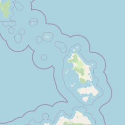
Map view of Strzelecki National Park

Use this park location map to pinpoint Strzelecki National Park in Australia, understand its exact geographic position, and read its mapped placement within the surrounding landscape more clearly.

Pigeon | © OpenStreetMap contributors

Location context for Strzelecki National Park

Tasmania
Park atlas

Discover additional protected landscapes and regional park geography surrounding Flinders Island within broader Australia.

Explore Other National Parks and Protected Areas Near Strzelecki National Park, Tasmania
After exploring Strzelecki National Park on Flinders Island, browse a curated list of other national parks and protected areas across Tasmania and broader Australia. Compare mapped park geography, regional conservation landscapes, and diverse protected environments to continue your atlas-style discovery of Australia's remarkable natural heritage.
National parkTasmania

Mount William National Park: Protected Landscape and National Park Atlas Details

Discover mapped geography and protected area context within Tasmania.

Mount William National Park stands as a vital protected area within Tasmania's vast network of natural landscapes. This detailed entry focuses on its identity as a national park, providing essential geographic context and mapped boundaries for atlas exploration. Understanding Mount William National Park's place in Tasmania's regional geography allows for a richer appreciation of Australia's protected lands.

Area
184.39 km²
Established
1973
IUCN
II
Relief
Lowland
National parkTasmania

Kent Group National Park: Protected Landscape in Tasmania, Australia

National Park mapping and geographic context.

Kent Group National Park is an essential protected natural area situated within Tasmania, Australia. This national park offers a clear example of a mapped protected landscape, contributing to the understanding of regional geography and conservation efforts in Tasmania. MoriAtlas provides structured data to explore its boundaries and geographic significance, aiding in a comprehensive atlas-style discovery of its protected natural identity.

Area
312.83 km²
Established
1971
IUCN
II
Scope
Mixed
National parkTasmania

Narawntapu National Park: Tasmania's Coastal Protected Landscape and Wildlife Atlas

Explore mapped boundaries, heathland, woodland, and intertidal bird habitats.

Narawntapu National Park showcases a remarkable protected coastal landscape on Tasmania's north coast, renowned for its exceptional density of marsupial wildlife and significant intertidal bird populations. Its diverse terrain, including heathland, woodland, and extensive mudflats, offers unique opportunities for geographic discovery and understanding the park's ecological importance. Examine its mapped natural features and protected status within the broader atlas of Australian reserves.

Area
43.49 km²
Established
1976
IUCN
II
Visitors
10.1K annual
Watercolor illustration of a landscape featuring hills, trees, and a winding river
National parkTasmania

Douglas-Apsley National Park: Discover its Protected Landscape and Geographic Context in Tasmania

Mapped boundaries and regional terrain of a key Tasmanian national park.

Delve into the geographic details of Douglas-Apsley National Park, a designated national park situated in Tasmania, Australia. This entry provides insight into the park's protected landscape identity, its mapped boundaries, and its contribution to the rich regional geography of Tasmania. Understanding its place within the island's natural terrain is crucial for comprehensive atlas-driven exploration and appreciating Australia's protected areas.

Area
160.8 km²
Established
1989
IUCN
II
Relief
Upland
Marine protected area

Wilsons Promontory Marine National Park: Australia's Southern Marine Protected Landscape

Explore mapped boundaries and island ecosystems at the edge of Bass Strait.

Wilsons Promontory Marine National Park, a 15,500-hectare marine protected area in Victoria, Australia, offers unique atlas exploration of its coastal and island geography. The park's waters surround the Glennie and Anser island groups, showcasing a complex marine terrain where Bass Strait transitions into the Southern Ocean. It complements the adjacent terrestrial national park, creating a comprehensive protected landscape vital for marine biodiversity and regional geographic context. Discover its mapped marine environment and ecologically significant island habitats.

Area
155 km²
Established
2003
IUCN
II
Scope
Marine
National park

Wilsons Promontory National Park: Southernmost Australian National Park with Granite Landscapes and Rainforests

Mapped geography of a dramatic coastal and wilderness park.

Wilsons Promontory National Park, situated at Australia's southern mainland extremity, represents a significant protected landscape. The park's geography is defined by ancient granite formations, creating dramatic peaks and headlands that meet the Bass Strait. Within its boundaries, diverse ecosystems flourish, including rare temperate rainforests and heathy woodlands. This page provides detailed geographic context and atlas-style discovery for this iconic protected area.

Area
505 km²
Established
1898
IUCN
II
Relief
Mixed relief
National parkTasmania

Freycinet National Park: Iconic Granite Peaks and Protected Coastal Landscape in Tasmania

Mapped geography and distinct terrain of Tasmania's historic national park.

Freycinet National Park on Tasmania's east coast is a remarkable protected landscape defined by its dramatic granite mountains, including The Hazards, and the pristine Wineglass Bay. Established as one of Tasmania's first national parks, it showcases unique geological formations and coastal ecosystems across its rugged terrain. This detailed view provides an atlas-style exploration of its mapped boundaries and geographic significance within the regional context.

Area
169 km²
Established
1916
IUCN
II
Visitors
200K annual
Marine protected area

Ninety Mile Beach Marine National Park: Victoria's Coastal Marine Protected Area

Mapped boundaries and temperate marine landscape context.

Ninety Mile Beach Marine National Park represents a significant commitment to marine conservation along the eastern Victorian coast. This protected area safeguards the underwater ecosystems adjacent to the celebrated Ninety Mile Beach, a nearly 100-kilometer stretch of continuous sandy shoreline. Its establishment in 2002 preserves the marine biodiversity and coastal landscape character of this region, forming an integral part of Victoria's network of protected coastal environments and offering a distinct view of Australia's marine geography.

Area
27.5 km²
Established
2002
IUCN
II
Scope
Marine

Common questions about visiting, size, designation, and location context for Strzelecki National Park

Strzelecki National Park FAQs for park facts, access, geography, and protected area context
Find quick answers about Strzelecki National Park, including protected-area facts, park geography, trail and visitor context, and how the park fits into its surrounding country and regional landscape.
MoriAtlas Explorer

Continue Your Protected Areas Search Across the Global Atlas

Deepen your exploration by continuing the structured search for national parks and protected areas worldwide. Utilize the comprehensive filtering capabilities to compare different conservation landscapes and refine your understanding of global park geography. Discover more about the distribution and characteristics of protected natural areas.

Global natural geography