

Mori Atlas logo
Wildlife reserveSubic Watershed Forest Reserve

Examining the ecological terrain, watershed boundaries, and mosaic forest landscapes of Luzon.

Subic Watershed Forest Reserve: A Protected Wildlife Sanctuary within the Bataan Mountain Landscape

The Subic Watershed Forest Reserve encompasses a significant protected landscape stretching from the volcanic slopes of Mount Natib toward the shores of Subic Bay. This wildlife reserve functions as a critical watershed for the surrounding region, maintaining a complex mosaic of evergreen lowland rainforest and open grass savannas. Its strategic geography links volcanic highlands with coastal environments, serving as a permanent sanctuary for numerous endemic Philippine species and contributing to the broader Zambales Biosphere Reserve.

lowland rainforestwatershed reservegrass savannaLuzonPhilippinesSubic Bay

Subic Watershed Forest Reserve

Wildlife reserve

Park overview

Structured park overview, official facts, and landscape profile for Subic Watershed Forest Reserve

Subic Watershed Forest Reserve park facts, protected area profile, and essential visitor context

Review the core facts for Subic Watershed Forest Reserve, including designation, size, terrain, visitor scale, habitats, and operating context in one park-focused overview.

About Subic Watershed Forest Reserve

The Subic Watershed Forest Reserve occupies a strategic position on the western side of Luzon, bridging the highland slopes around Mount Natib and the coastal lowlands around Subic Bay. As its name suggests, the reserve's primary landscape function is watershed protection, safeguarding the forested catchments that supply water to the Subic Bay area while preserving a substantial block of lowland tropical forest.

The reserve sits within a transitional ecological zone where grass savannas and evergreen lowland rainforest intermingle, creating habitat diversity that supports a rich community of plants and animals. Botanical work in the reserve and surrounding forest blocks has recorded roughly 745 plant species across the broader forested landscape, underscoring the area's value as a refuge for native flora in a region where lowland forests have been heavily reduced.

The reserve also has a notable geopolitical and conservation history. Portions of the present-day protected area once lay within the United States Naval Base Subic Bay and transitioned into conservation management after the military withdrawal. It now borders the Subic Bay Freeport Zone and connects ecologically with Bataan National Park to the southeast, collectively forming the forested backbone of the Zambales mountain range's western flank. Together with its neighbors, it contributes to the Zambales Biosphere Reserve, one of the larger protected landscape complexes in Central Luzon.

Protection and recognition

Documented terrestrial protection scope and baseline administrative records

Subic Watershed Forest Reserve Protection Status and Governance Data

Subic Watershed Forest Reserve holds a documented terrestrial protection scope within the global protected area registry. Official database records outline the baseline conservation designation parameters and administrative tracking identifiers.

Protection details

Protection scope
Terrestrial
Transboundary protection
No
WDPA ID
14723
Park context

Deeper park guide and search-rich context for Subic Watershed Forest Reserve

Subic Watershed Forest Reserve history, landscape, wildlife, and travel context

Explore Subic Watershed Forest Reserve through its history, landscape character, ecosystems, wildlife, conservation priorities, cultural context, and seasonal travel timing in a structured park guide built for atlas discovery and search intent.

Why Subic Watershed Forest Reserve stands out

The Subic Watershed Forest Reserve is best known for protecting a mosaic of lowland rainforest and grass savanna on Luzon, for its role as a watershed feeding Subic Bay, and for harboring several Philippine-endemic mammals and birds. Its location on former United States Naval Base Subic Bay land gives it a distinctive history of transitioning from military territory to a conservation reserve, while its inclusion in the Zambales Biosphere Reserve highlights its regional ecological importance.

Subic Watershed Forest Reserve history and protected-area timeline

The Subic Watershed Forest Reserve was formally established in 1992 through the enactment of Republic Act 7227. The law created the Subic Bay Freeport Zone from former United States military lands and set aside surrounding forest areas as a protected watershed reserve.

Before this transition, a portion of the reserve had been administered as part of the United States Naval Base Subic Bay. The withdrawal of U.S. naval forces from the Philippines made this land available for new civilian and conservation uses. The forest reserve was therefore designed not only to protect native ecosystems but also to secure a reliable water supply for the growing Subic Bay Freeport Zone and surrounding communities.

The reserve's forests had already been heavily impacted before and around the time of its establishment. The eruption of Mount Pinatubo in 1991, just to the north, blanketed large areas in volcanic ash and caused lasting damage to forest cover. Continuing pressures such as slash-and-burn agriculture and illegal logging have been identified as ongoing threats, making the reserve a reflection of both successful forest protection legislation and the long struggle to maintain lowland forest integrity in the Philippines.

Subic Watershed Forest Reserve landscape and geographic character

The Subic Watershed Forest Reserve occupies the northwestern flank of Mount Natib, a volcanic highland in the Zambales mountain range, and descends toward the shores of Subic Bay. Its terrain therefore ranges from steep upper slopes and ridge systems to lower, more gently contoured forest land along the bay.

A defining feature of the landscape is the contrast between open grass savannas and patches of closed evergreen lowland rainforest. This savanna-forest mosaic gives the reserve an unusually varied appearance, with grassy clearings, woodland edges, and denser forest stands alternating across the watershed. Around the reserve's margins, agricultural fields and settled areas intermingle with the forested terrain.

The wider landscape includes the dramatic volcanic backdrop of Mount Natib, the deep Subic Bay coastline, and, in the south, the forested highlands that link into Bataan National Park. The 1991 eruption of Mount Pinatubo reshaped parts of this region, depositing ash and altering vegetation patterns across the western Luzon corridor. Together, these features make the reserve a visually and ecologically diverse mountain-to-coast landscape.

Subic Watershed Forest Reserve ecosystems, habitats, and plant life

Ecologically, the Subic Watershed Forest Reserve lies at the interface between tropical lowland rainforest and tropical grass savanna, a combination that is relatively unusual in the Philippine landscape. The reserve's lowland forests are remnants of once more extensive rainforests that historically covered much of western Luzon.

The forested blocks within and around the reserve support a recorded plant community of roughly 745 species, reflecting the heterogeneity of the savanna-forest mosaic and the range of elevations from coastal lowlands up into the Mount Natib slopes. The mix of open grassland areas and closed-canopy forest creates distinct microhabitats, with the savannas favoring grasses, fire-adapted species, and open-country fauna, while the forests maintain shade-loving trees and forest interior wildlife.

The reserve is embedded in the larger Zambales Biosphere Reserve and is adjacent to Bataan National Park, so its ecological functions are best understood in connection with these surrounding protected landscapes. Together they maintain a corridor of forest habitat along the Zambales mountain range, which is increasingly important as lowland forest elsewhere on Luzon continues to be cleared for agriculture and settlement.

Subic Watershed Forest Reserve wildlife and species highlights

The Subic Watershed Forest Reserve harbors a notable concentration of Philippine-endemic mammals and birds, making it an important area for fauna conservation on Luzon. Among its resident mammals are the northern giant cloud rat, the golden-crowned flying fox, the Philippine deer, and the Philippine warty pig.

The birdlife is similarly distinctive. Recorded species include the Philippine duck, the Philippine hawk-eagle, the red-vented cockatoo, the Luzon racket-tailed parrot, the Philippine eagle-owl, and the green-faced parrotfinch. Several of these birds are endemic to the Philippines, and others are of significant conservation concern, which is why the area has been highlighted by international organizations such as BirdLife International.

The combination of forest and open grassland habitats allows the reserve to support both forest-dependent species and those that require more open or edge environments. This habitat diversity, combined with the reserve's connection to neighboring protected areas, contributes to its role in sustaining viable populations of endemic wildlife in Central Luzon.

Subic Watershed Forest Reserve conservation status and protection priorities

The Subic Watershed Forest Reserve is significant for conservation because it protects one of the remaining lowland forest and savanna complexes on western Luzon, an island where lowland rainforests have been disproportionately lost to agriculture, logging, and settlement. By safeguarding the watershed feeding Subic Bay, the reserve also serves a critical hydrological function for the Subic Bay Freeport Zone and adjacent communities.

The reserve is integrated into a broader conservation framework that includes the neighboring Bataan National Park and the wider Zambales Biosphere Reserve, giving it importance beyond its own boundaries as part of a regional network of protected landscapes. Its designation under Republic Act 7227 in 1992 reflects a deliberate effort to convert former military land into long-term conservation infrastructure.

Despite this protected status, the reserve faces ongoing pressures. Slash-and-burn agriculture continues along its margins, illegal logging remains a threat to the forest interior, and the legacy of the 1991 Mount Pinatubo eruption has left lasting impacts on forest health. Conservation attention in the reserve therefore centers on maintaining forest cover, controlling encroachment, and supporting the recovery of native flora and fauna populations in a landscape that has already endured multiple disturbance events.

Subic Watershed Forest Reserve cultural meaning and human context

The reserve's cultural and human context is tightly bound to the modern history of Subic Bay. Parts of the present protected area once belonged to the United States Naval Base Subic Bay, a major U.S. military installation for several decades, and only became accessible to the public and to conservation programs after the withdrawal of U.S. forces in the early 1990s.

The creation of the Subic Bay Freeport Zone on former base land, combined with the designation of the watershed reserve, represents a deliberate shift in how this coastal and mountain landscape is used and valued. Local communities around the reserve engage in small-scale agriculture in the marginal zones of the protected area, while the Freeport Zone has become a center for commerce, shipping, and tourism to the north.

The reserve is also embedded in the regional identity of the Zambales and Bataan provinces, whose mountainous western flank is increasingly associated with biodiversity tourism, environmental education, and watershed stewardship, in addition to its traditional role in fisheries, farming, and coastal livelihoods.

Top sights and standout views in Subic Watershed Forest Reserve

The Subic Watershed Forest Reserve stands out for the unusual coexistence of tropical lowland rainforest and grass savanna on Luzon, for its location on former U.S. naval base land that has been repurposed for conservation, and for its role as part of the larger Zambales Biosphere Reserve. Its position between Mount Natib and Subic Bay gives it both watershed and biodiversity significance, while its protected status under Republic Act 7227 anchors it within the regional conservation framework of Central Luzon.
Monthly climate preview

Long-term representative monthly averages for temperature and rainfall rhythms in Bataan

Subic Watershed Forest Reserve Climate Normals, Annual Temperature and Precipitation

Subic Watershed Forest Reserve records long-term average monthly temperatures ranging from 25.98 degrees Celsius to 29.25 degrees Celsius alongside distinct precipitation variations from 0.39 mm per day up to 21.42 mm per day. Reviewing the complete twelve-month dataset provides a thorough baseline for analyzing regional thermal trends and moisture distribution across the coordinate point.
Annual mean27 °C
26 °C29 °C
Jan26°
Feb27°
Mar28°
Apr29°
May29°
Jun28°
Jul27°
Aug27°
Sep27°
Oct27°
Nov27°
Dec26°
Warmest month
April

29.3 °C

Coolest month
January

26 °C

Wettest month
August

21.4 mm/day

Driest month
January

0.4 mm/day

Park location guide

Geography guide, regional context, and park location map for Subic Watershed Forest Reserve

Subic Watershed Forest Reserve park geography, regions, and map view in Philippines

Understand where Subic Watershed Forest Reserve sits in Philippines through a broader geographic reading of the surrounding landscape, nearby location context, and its mapped position within the national park landscape.

How Subic Watershed Forest Reserve fits into Philippines

The Philippines, officially the Republic of the Philippines, is an archipelagic nation in Southeast Asia comprising approximately 7,641 islands categorized into three main geographical divisions: Luzon, Visayas, and Mindanao. Located in the western Pacific Ocean, it shares maritime borders with Taiwan, Japan, Palau, Indonesia, Malaysia, Vietnam, and China. Manila serves as the capital city, while Quezon City is the most populated city, both within Metro Manila.

Wider geography shaping Subic Watershed Forest Reserve in Philippines

The Philippines is an archipelagic nation in Southeast Asia, positioned in the western Pacific Ocean. Its islands are bounded by the South China Sea to the west, Philippine Sea to the east, and Celebes Sea to the south. The country shares maritime borders with Taiwan to the north, Japan to the northeast, Palau to the east and southeast, Indonesia to the south, Malaysia to the southwest, Vietnam to the west, and China to the northwest.

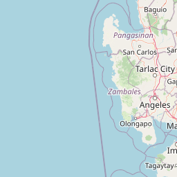
Map view of Subic Watershed Forest Reserve

Use this park location map to pinpoint Subic Watershed Forest Reserve in Philippines, understand its exact geographic position, and read its mapped placement within the surrounding landscape more clearly.

Pigeon | © OpenStreetMap contributors

Location context for Subic Watershed Forest Reserve

BataanZambales
Park atlas

Compare regional protected areas and connected forest landscapes across western Luzon

Explore Parks Near Subic Watershed Forest Reserve and Surrounding Protected Lands

Browsing nearby national parks and protected areas provides deeper context for the lowland rainforest mosaic surrounding Subic Watershed Forest Reserve. Extending the geographic comparison reveals broader ecological patterns across the Zambales mountain corridor and neighboring regional reserves.
National parkZambales
About 8 km away#1 closest

North

Olongapo Naval Base Perimeter National Park: Philippines National Park & Protected Landscape in Zambales

Coastal terrain and historical military land context.

Discover Olongapo Naval Base Perimeter National Park, a protected landscape within Zambales province, Philippines. Established adjacent to the former U.S. Naval Base Subic Bay perimeter, this small national park preserves a unique coastal fringe. Its mapped boundaries offer insights into a transitional zone, serving as a green corridor and protecting a fragment of the region's natural habitat. Explore the distinct geographical and historical significance of this protected area.

Area
0.09 km²
Established
1968
IUCN
V
Scope
Terrestrial
Protected landscapeCentral Luzon
About 10 km away#2 closest

North

Roosevelt Protected Landscape: Mapped Geography and Protected Area Context

A preserved grassland and forest mosaic in the Zambales Mountain Range.

Roosevelt Protected Landscape serves as a vital ecological corridor within the Bataan province of Central Luzon. The area is defined by its wide savanna-like terrain dominated by cogon and talahib grasses, punctuated by pockets of old-growth forest and riparian zones along the Cucubog and Olongi rivers. This site offers a unique look at long-term conservation history within a landscape framed by the prominent peaks of Mount Santa Rita and Mount Malasimbo.

Area
7.86 km²
Established
1933
IUCN
V
Relief
Mountain
National parkBataan
About 35 km away#3 closest

East

Bataan National Park: Philippines Protected Landscape and National Park Geography

Mapped boundaries and regional natural landscape context.

This detail entry for Bataan National Park provides essential context for understanding its role as a protected landscape within the Philippines. Users can explore the park's mapped boundaries, its geographic setting in the Bataan region, and its identity as a national park. The focus is on atlas-style discovery, allowing for a deeper appreciation of the park's natural terrain and its place within the country's protected area network.

Area
236.88 km²
Established
1945
IUCN
II
Relief
Mountain
National parkPhilippines
About 69 km away#4 closest

Northeast

Mount Arayat National Park: Philippines National Park and Protected Landscape Atlas Entry

Mapped geography and protected natural landscape context.

Mount Arayat National Park represents a distinct protected area within the Philippines, serving as a focal point for geographic and landscape exploration. This detailed entry offers insight into its mapped boundaries and its significance as a national park within the archipelago's rich natural tapestry. Users can leverage this information for structured discovery of the park's terrain and its place in the regional geography of the Philippines.

Relief
Mountain
Climate
Tropical
Scope
Terrestrial
Protected areaMetro Manila
About 80 km away#5 closest

East

Las Piñas, Parañaque Wetland Park: Protected Coastal Geography in Metro Manila

Mangroves, tidal mudflats, and essential avian migratory corridors.

Discover the geographic layout and protected status of Las Piñas, Parañaque Wetland Park. This coastal refuge provides a rare natural contrast to the dense urbanization of Metro Manila, safeguarding critical mangrove habitats and tidal environments that support diverse migratory bird species.

Area
1.81 km²
Established
2007
Relief
Lowland
Climate
Tropical
Nature reserveMetro Manila
About 87 km away#6 closest

East

La Mesa Watershed Reservation: Mapping the Urban Rainforest and Water Catchment

A critical nature reserve within the Metro Manila region.

La Mesa Watershed Reservation is the last major lowland forest block within Metro Manila, functioning as a vital nature reserve and drinking water catchment for the metropolitan area. The area features a complex mosaic of closed-canopy rainforest, reservoir wetlands, and swampforest, providing a distinct geographic counterpoint to the surrounding urban density. It remains a key case study in urban conservation and hydrological management for the Philippine capital.

Area
26.59 km²
Established
2007
Visitors
300K annual
Relief
Upland
National parkBulacan
About 92 km away#7 closest

Northeast

Biak-na-Bato National Park: National Park Atlas and Geographic Context in Bulacan

Explore protected landscapes and mapped terrain.

Biak-na-Bato National Park is a key protected area in Bulacan, Philippines, identified for its national park designation. This entry provides specific details on its geographic positioning and mapped features, essential for atlas-based research and understanding the distribution of protected lands within the region. Dive into the landscape context and mapped boundaries that define this significant natural entity.

Area
21.17 km²
Established
1937
IUCN
V
Relief
Mountain
Nature reserveBulacan
About 99 km away#8 closest

East

Angat Watershed Forest Reserve: Mountain Watershed Geography and Protected Forest Terrain

A critical nature reserve in the Sierra Madre of Bulacan

This protected area anchors the water supply for Metro Manila while preserving extensive submontane forests and mountain ridges in Central Luzon. The landscape features deep river valleys, hydroelectric reservoirs, and peaks like Mount Oriod that define the local geography of this important conservation zone.

Area
623.09 km²
Established
1927
IUCN
VI
Relief
Mountain

Common questions about visiting, size, designation, and location context for Subic Watershed Forest Reserve

Subic Watershed Forest Reserve FAQs for park facts, access, geography, and protected area context

Find quick answers about Subic Watershed Forest Reserve, including protected-area facts, park geography, trail and visitor context, and how the park fits into its surrounding country and regional landscape.
MoriAtlas Explorer

Continue Your Protected Areas Search Across the Global Atlas

Deepen your exploration by continuing the structured search for national parks and protected areas worldwide. Utilize the comprehensive filtering capabilities to compare different conservation landscapes and refine your understanding of global park geography. Discover more about the distribution and characteristics of protected natural areas.

Global natural geography