
Viewpoints
Park geography
Analyzing the wetland terrain, spatial distribution, and riverine features within this Spanish protected area.
Comprehensive Geographic Profile and Mapped Boundaries of Tablas de Daimiel National Park
This geographic profile examines the physical boundaries and environmental composition of Tablas de Daimiel National Park in the Castilla-La Mancha region of Spain. The park encompasses 30.3 square kilometers of lowland terrain defined by the intersection of the Guadiana and Cigüela rivers, forming a unique wetland landscape. Detailed spatial analysis includes a perimeter of nearly 50 kilometers and a network of internal islands and observation sites.
Spain's smallest national park protecting a unique wetland oasis in the arid La Mancha plain
Tablas de Daimiel National Park
Tablas de Daimiel National Park is a wetland protected area located on the La Mancha plain in the province of Ciudad Real, Castilla-La Mancha, Spain. Established in 1973, it represents the last surviving example of floodplain wetlands in the arid central part of the Iberian Peninsula. The park occupies approximately 3,030 hectares, making it the smallest of Spain's fifteen national parks. The wetland forms at the confluence of two rivers of contrasting nature: the Guadiana, which contributes fresh water from underground springs, and the Gigüela, which carries brackish waters. This unique hydrological combination creates a privileged ecosystem supporting exceptional biodiversity. The park serves as a critical waypoint for migratory birds traveling between northern Europe and Africa, hosting tens of thousands of waterfowl annually. Beyond its national significance, Tablas de Daimiel holds international protection as a Ramsar wetland, forms the core of the Mancha Húmeda Biosphere Reserve, and operates as a Special Protection Area for birds under European Union law.
- Location
- Spain
- Park type
- National park
- Established
- 1973
- Area
- 30.3 km²
Location overview
Administrative placement in Castilla-La Mancha and Ciudad Real
Exploring the Geography of Tablas de Daimiel National Park in Spain
Tablas de Daimiel National Park sits within the Ciudad Real province of Castilla-La Mancha in Spain. Records confirm its status as an inland, single-country protected area without coastal or marine borders.
- Countries
- Spain
- Regions
- Castilla-La Mancha, Ciudad Real
- Primary location
- Spain
- Geographic setting
- Inland
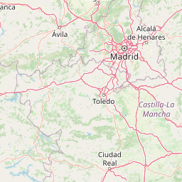
Boundary and coordinates
Interactive protected perimeter geometry and measured spatial dimensions
Tablas de Daimiel National Park Boundary Map and Spatial Extent
Mapped park outlines provide precise spatial context for the protected territory. Accompanying factual panels display recorded area metrics, coordinate limits, and geographic spans.
- Boundary area
- 31.1 km²
- Boundary perimeter
- 49.8 km
- Northernmost point
- 39.1889° N
- Southernmost point
- 39.1108° N
- Easternmost point
- 3.6473° W
- Westernmost point
- 3.7735° W
- Geographic centre
- 39.1474° N, 3.7075° W
- North–south span
- 8.7 km
- East–west span
- 10.9 km
Terrain and natural features
Lowland relief classification and recorded interior geographical features
Tablas de Daimiel National Park Terrain and Named Natural Features
Stored lowland terrain classifications define the mapped layout alongside recorded wetlands, rivers, and islands. Linked feature cards supply specific names, types, and spatial relationships across the protected landscape.
Selected named natural features
Islands
Isla de los Tarayes
Islands
Isla de las Zarcas
Forests
Bosque de Tarayes
Wetlands
Tablas de Daimiel
Islands
Isla de Pan
Environmental setting
Wetland habitat types, arid climate zones, and lowland relief profiles.
Tablas de Daimiel National Park Environmental Classifications and Physical Setting
Recorded landscape features and dominant water classifications outline the physical setting across the protected area. Structured environmental categories connect recorded attributes to relevant atlas destinations.
- Relief
- Lowland
- Climate
- Arid
- Water
- Water-dominated
- Forest cover
- No forest cover
Landscape features
Wetland · Rivers · Lakes
Habitat types
Wetland · Riverine habitat · Lacustrine habitat
Park atlas
Discover the wider wetland geography and diverse protected landscapes of central Spain and Castilla-La Mancha.
Explore More National Parks and Protected Areas Near Tablas de Daimiel National Park
Discover other national parks and protected areas within the regional context of Tablas de Daimiel National Park, including significant wetland ecosystems and diverse conservation landscapes. Compare adjacent protected areas, trace ecological connections, and map the broader spread of Spain's interior natural heritage through structured geographic context.
National parkToledo Province
48 km away#1 closest
West

Cabañeros National Park: Spain's Premier Iberian Oak Woodland Protected Landscape
Mapped Geography of Montes de Toledo Protected Area
Cabañeros National Park is celebrated as the most extensive and well-conserved example of Iberian Mediterranean forest in Spain. Situated within the Montes de Toledo, the park features a remarkable dichotomy between its unique raña flatlands and mountainous sierras, harboring ancient oak woodlands and significant biodiversity. This national park serves as a crucial component of the region's geographic context and a prime destination for atlas-based discovery of protected landscapes.
- Area
- 409 km²
- Established
- 1995
- IUCN
- II
- Visitors
- 104.6K annual
Biosphere reserveExtremadura
About 114 km away#2 closest
West
La Siberia Biosphere Reserve: Mapped Geography and Protected Lands of Extremadura
A study of reservoir coastlines and Mediterranean serranías
La Siberia Biosphere Reserve offers a deep look into the rural landscape of Extremadura, Spain. Characterized by five major reservoirs and vast Mediterranean oak dehesas, the area provides essential habitat for raptors and preserves significant prehistoric rock art within its complex serranía topography. Explore the geographic boundaries and water-dominated landscape of this distinct inland region.
- Area
- 2,836.7 km²
- Established
- 2019
- Relief
- Mountain
- Climate
- Mediterranean
National parkSpain
173 km away#3 closest
North
Sierra de Guadarrama National Park: Protected Area Landscape and Geographic Context
Explore diverse high Mediterranean mountain terrain and ecosystems.
Sierra de Guadarrama National Park is a significant protected national park in central Spain, characterized by its extensive granite landscapes and eleven distinct ecosystems. This park protects crucial high Mediterranean mountain environments, ancient pine forests, and dramatic glacial formations. Its geographic position within the Sistema Central makes it essential for understanding the regional geography and mapped terrain of the Iberian Peninsula, offering a unique look at a vital protected landscape.
- Area
- 339.6 km²
- Established
- 2013
- IUCN
- II
- Visitors
- 3M annual
National parkExtremadura
183 km away#4 closest
West
Monfragüe National Park: Dramatic Cliffs, Raptor Haven, and Extremadura's Protected Landscape
Discover its mapped terrain and unique geography in Spain.
Monfragüe National Park, situated in Extremadura, Spain, offers a compelling study in protected landscape geography. The park's identity is shaped by its formidable cliffs and river valleys carved by the Tagus, providing critical nesting grounds for European raptors. This MoriAtlas entry details the park's mapped boundaries and its significance as a vital protected area within the region. Users can explore the specific natural terrain and regional context that establish Monfragüe as a unique protected territory.
- Area
- 179 km²
- Established
- 2007
- IUCN
- II
- Visitors
- 331.8K annual
Biosphere reserveMadrid
199 km away#5 closest
North
Sierra del Rincón Biosphere Reserve: Mountain Geography and Protected Landscape Analysis
Transitional mountain terrain in the Sierra Norte region of Madrid
Sierra del Rincón provides a unique study of ecological compression, where Atlantic-flavored beech groves meet Mediterranean oak and highland shrublands. This protected mountain territory in Madrid integrates rich forest habitats with traditional agro-silvopastoral village life, making it a critical reference for understanding the transitional geography of the Iberian Central System.
- Area
- 152.31 km²
- Established
- 2005
- Relief
- Mountain
- Climate
- Alpine
National parkSpain
About 210 km away#6 closest
West
Monfragüe National Park: Protected Landscape Atlas of Spanish Raptor Colonies
Explore mapped terrain and regional geography within this Spanish National Park.
As a national park in Spain's Extremadura region, Monfragüe National Park offers a distinct protected landscape shaped by the Tagus River and dramatic limestone cliffs. It is globally recognized for its exceptional birdlife, especially its large griffon vulture colonies and populations of Spanish imperial eagles, making it a significant site for ecological study and atlas-based exploration of protected areas. The park's landscape, characterized by Mediterranean woodlands and rugged terrain, provides crucial habitat and a unique geographic context for understanding Iberian Peninsula conservation.
- IUCN
- II
- Scope
- Terrestrial
National parkAndalusia
215 km away#7 closest
South
Sierra Nevada National Park: Protected Alpine Terrain and Geographic Context in Andalusia
Explore Spain's highest mountain range mapped across Andalusia's atlas.
Sierra Nevada National Park offers a profound exploration of Spain's highest alpine environments and a significant entry in the regional geography atlas. This protected area showcases classic glacial landforms, U-shaped valleys, and numerous high-mountain lakes, alongside a remarkable abundance of endemic plant species thriving in its unique microclimates. Understanding its mapped boundaries reveals a landscape vital for both biodiversity and watershed, situated prominently within the broader geographic context of Andalusia.
- Area
- 858.83 km²
- Established
- 1999
- IUCN
- II
- Relief
- Mountain
Nature reserveAndalusia
261 km away#8 closest
South
Acantilados de Maro-Cerro Gordo: Protected Coastal Cliffs and Marine Geography Atlas
Mapping the rugged Mediterranean boundary in Andalusia, Spain
Discover the complex geography of Acantilados de Maro-Cerro Gordo, a protected nature reserve defined by vertical cliffs exceeding 200 meters and isolated coastal coves. This atlas entry details the transition between Betic mountain terrain and marine ecosystems, documenting prominent headlands like Cerro Gordo and the biological richness of its protected reefs and seagrass meadows.
- Area
- 19.129 km²
- Established
- 1989
- Relief
- Upland
- Climate
- Mediterranean
MoriAtlas Explorer
Continue Exploring Tablas de Daimiel National Park's Mapped Wetland Geography and Regional Context
Understand the full geographic scope and ecological importance of Tablas de Daimiel National Park by exploring its mapped features and relationship to the surrounding region. MoriAtlas provides detailed context on protected areas, allowing for deeper understanding of this unique Spanish wetland and its vital role in migratory bird flyways. Continue your atlas discovery journey into the mapped terrain and conservation significance of this exceptional national park.
Browse next
Global natural geography
Explore related park routes
Explore MoriAtlas Global ParksBrowse All MoriAtlas ParksGlobal Park Map DiscoveryMoriAtlas: Browse All CountriesBrowse All MoriAtlas ContinentsNational Park Environment AtlasGrand Canyon National Park AtlasYellowstone National Park AtlasYosemite National Park Atlas and GeographySerengeti National Park AtlasGalápagos National Park Protected LandscapeBanff National Park Geography and AtlasKruger National Park Atlas EntryUluṟu-Kata Tjuṯa National Park AtlasExplore Uluru-Kata Tjuta National Park GeographyPlitvice Lakes National Park AtlasFiordland National Park Protected LandscapeGreat Smoky Mountains National Park AtlasAfghanistan National Parks and Protected AreasAlbania National Parks and Protected AreasAlgeria National Parks and Protected AreasAmerican Samoa National Parks and Protected AreasAndorra National Parks and Protected AreasAngola National Parks and Protected AreasAntarctica National Parks and Protected AreasAntigua and Barbuda Park List